First "Elevated" Severe Thunderstorm Risk of 2023 Incoming to Southern Ontario (Wed, Apr 5, 2023)

NOTE: You can click on the map to open a zoomable image which will be easier to read.

Forecaster: Brennen Perry & Adam Skinner

Published: Tuesday, April 4, 2023


A line of severe thunderstorms is possible across Southwestern Ontario on Wednesday and the risk will extend into isolated parts of Central, Niagara and the GTHA. The morning will bring heavy rain, hail and thunderstorms but the afternoon and evening will bring the strongest risk for damaging wind gusts (120km/h+), large hail (2-4cm), isolated flooding (50mm+) and frequent lightning. While the strongest risk remains stateside, the possibility of intense storms crossing continues to increase with each model run.


Here is an advertisement so we can pay the bills:


NOTE: You can click on the map to open a zoomable image which will be easier to read.

We’ve also identified an isolated tornado risk for much of Southwestern Ontario, stretching into parts of the GTHA and Niagara. There is a slightly more enhanced risk in deep southwestern Ontario closer to the US border and Lake Erie as well. However, we’ve seen models suggesting the risk could be a bit more widespread and further to the north. We may upgrade this risk but for now, we feel an isolated tornado region covers the chance of isolated tornado spin-ups tomorrow.

Be sure to stay informed and monitor weather updates as this potent storm system approaches. The impact of freezing rain, heavy rainfall, and possible severe thunderstorms, combined with significant ice accretion and potential power outages, could cause some disruptions to daily routines and travel plans.

Make sure to check out our freezing rain and flood risk forecast.


Here is another advertisement so we can pay more bills:


Potent Storm Brings Freezing Rain, Heavy Rainfall, and Severe Thunderstorm Risk to Southern Ontario on Wednesday

NOTE: You can click on the map to open a zoomable image which will be easier to read.

Forecaster: Brennen Perry

Published: Tuesday, April 4, 2023


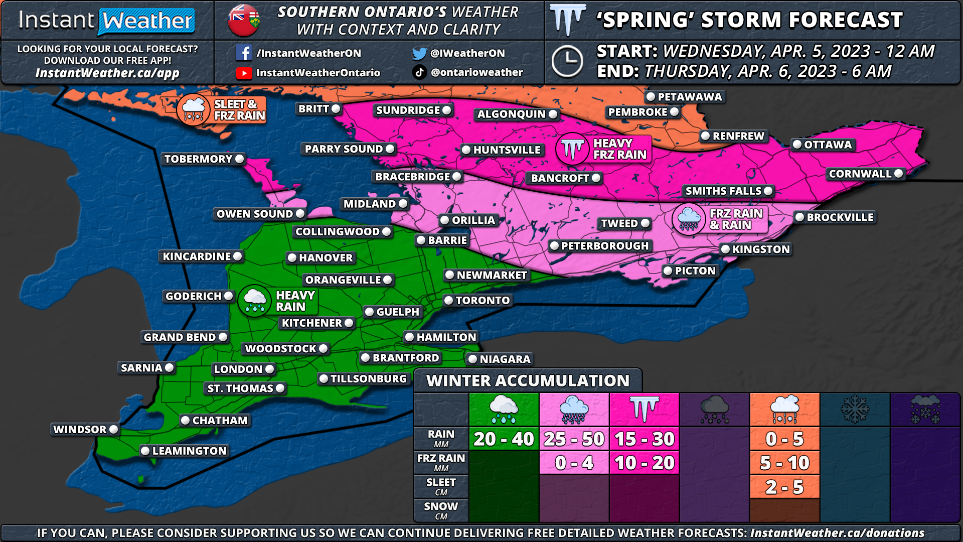
A powerful system arriving from the west is expected to deliver a variety of precipitation types and potential travel disruptions starting early Wednesday morning and lasting throughout the day in Southern Ontario. The strong storm system is expected to reach the region just after midnight, beginning around the Bruce Peninsula and Georgian Bay, before moving further eastward.

As the system encounters colder air over Central and Eastern Ontario, it will lead to the development of a widespread band of freezing rain during the morning hours. In the Ottawa Valley and Algonquin Park, precipitation may initially begin as ice pellets before transitioning to freezing rain. Heavy icing will impact regions such as Simcoe County, Muskoka, Kawartha Lakes, Haliburton, Peterborough, Bancroft, Brockville, Ottawa, Renfrew, Cornwall, and Pembroke.

Ice accretion in the hardest-hit regions could range from 10 to 20mm, and localized power outages cannot be ruled out. Travel conditions in the affected areas are expected to be hazardous due to ice accumulation on untreated surfaces. Consider postponing non-essential travel until late Wednesday and prepare for the likelihood of school bus cancellations throughout Central and Eastern Ontario.

Temperatures are forecast to rise gradually during the mid to late afternoon on Wednesday, which will change freezing rain to rain and help melt any ice accumulation. However, freezing rain may linger into the evening for the Ottawa Valley near the Quebec border.

In the meantime, the rest of Southern Ontario is expected to receive a soaking with 20 to 40mm of rainfall possible by the end of Wednesday. In some areas, particularly where thunderstorm activity occurs, rainfall amounts could be even higher, ranging from 50 to 75mm. This heavy rainfall may lead to localized flooding and ponding on roadways.

Additionally, there is potential for severe thunderstorms in Southwestern Ontario on Wednesday afternoon and early evening. While the strongest risk remains stateside, the possibility of storms crossing the border should not be overlooked, especially in areas like Windsor and Sarnia where the lakes have less influence. The main risks associated with these storms are strong wind gusts and even the chance of an isolated tornado can’t be ruled out. A thunderstorm risk map will be released later tonight and updated tomorrow as needed.

Be sure to stay informed and monitor weather updates as this potent storm system approaches. The impact of freezing rain, heavy rainfall, and possible severe thunderstorms, combined with significant ice accretion and potential power outages, could cause some disruptions to daily routines and travel plans.


Here is an advertisement so we can pay the bills:

Spring on Pause: Wintry Blast Brings Snow, Ice, and Heavy Rain to Ontario This Weekend

NOTE: You can click on the map to open a zoomable image which will be easier to read.

Forecaster: Brennen Perry

Published: Friday, March 24, 2023


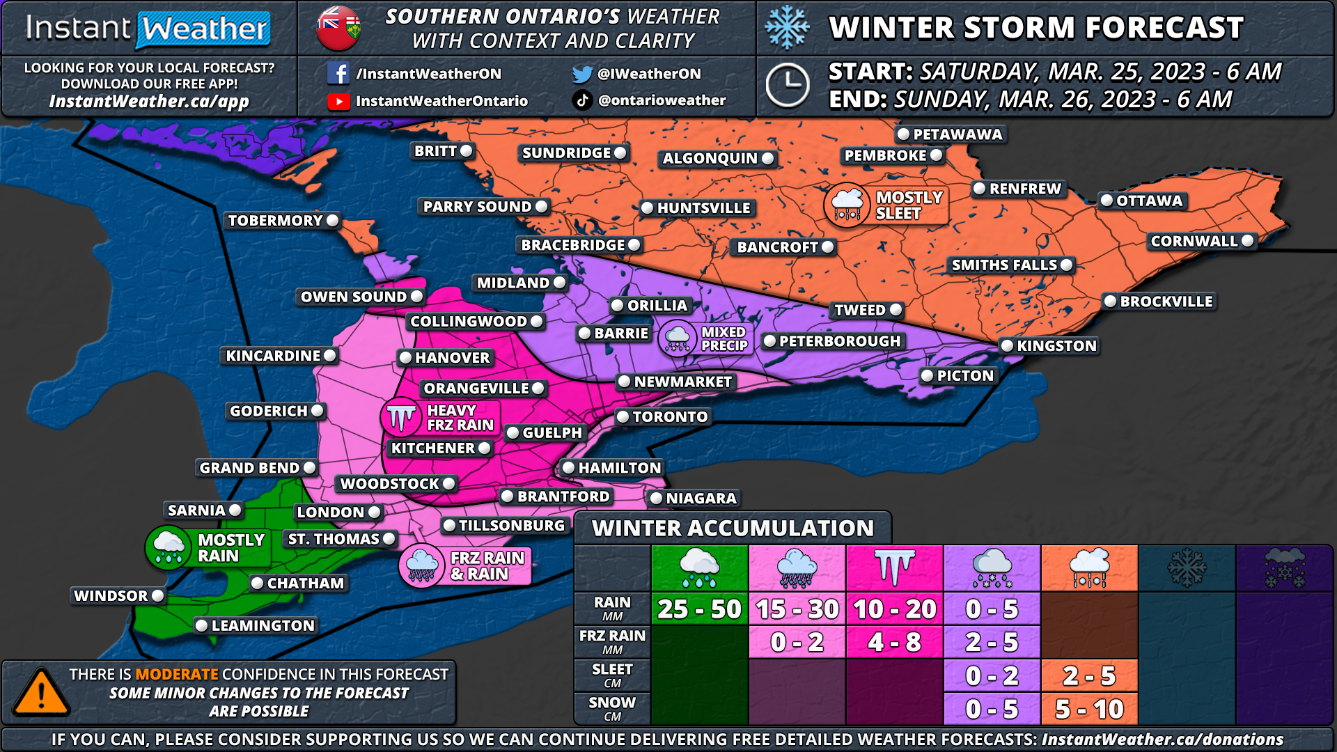
As spring arrives on the calendar, it seems Mother Nature has a different plan for Ontario this weekend. An approaching low-pressure system from the US Midwest is set to bring a mix of wintry precipitation, starting Saturday morning and lingering into Sunday.

Early Saturday morning, rain will begin in Deep Southwestern Ontario, affecting areas like Windsor, Leamington, and Chatham. As the system moves northeastward, colder air will create freezing rain across much of Southwestern Ontario. The worst conditions are expected in elevated regions such as the Dundalk Highlands, along the Niagara Escarpment, and the Hamilton Mountains, including areas like Orangeville, Shelburne, Guelph, Kitchener, and Halton Hills. Freezing rain will last for several hours on Saturday morning and early afternoon. Some minor freezing rain could also be an issue across the GTA and the Niagara region, but areas closer to the lakeshore will see less ice due to slightly warmer temperatures.

By noon, many areas will transition from freezing rain to rain, but higher elevations may experience freezing rain for a few more hours. Central and Eastern Ontario will see snow starting in the early afternoon, with ice pellets mixing in later in the day. The extent of ice pellets is uncertain and may affect overall snowfall totals. As temperatures drop in the evening, any remaining precipitation will transition to flurries or light snow across Southern Ontario.

NOTE: You can click on the map to open a zoomable image which will be easier to read.

Northeastern Ontario is in for a classic snowstorm, starting Saturday afternoon around Sudbury and North Bay. Heavy snow will continue into the evening and overnight, creating poor travel conditions across most of the southern portion of Northeastern Ontario, including Elliot Lake, Sudbury, North Bay, and Temiskaming Shores.

Overall accumulation will vary greatly, depending on the exact precipitation type and temperature. The highest snowfall totals will be in Northeastern Ontario, with up to 15-25cm possible. Central and Eastern Ontario can expect a quick 5-10cm of snow on Saturday afternoon before transitioning to ice pellets. Around 2-5cm of ice pellet accumulation is expected across Central and Eastern Ontario.

The worst icing is expected around Orangeville, Kitchener, Woodstock, Guelph, and York Region, with several millimetres of ice accretion possible. Some higher elevations could see 8-10mm of accretion, leading to ice damage and localized power outages. Heavy rainfall will also be a concern for Southwestern Ontario and the Golden Horseshoe, with up to 25-50mm of rainfall expected in Deep Southwestern Ontario, potentially causing flooding.

NOTE: You can click on the map to open a zoomable image which will be easier to read.

Strong wind gusts will accompany the system, with the strongest gusts expected during the late morning and early afternoon hours on Saturday. Damaging gusts up to 90-100km/h are possible along the northeastern shoreline of Lake Erie, including Port Colborne and Welland. Occasional 90km/h gusts may also affect the Lake Ontario shoreline and Southwestern Ontario. Winds in Central and Eastern Ontario will range from 60-80km/h.

The combination of wintry weather and strong winds will likely lead to poor travel conditions, especially in areas experiencing freezing rain, ice pellets, and snow. It's advisable to avoid travel during the early part of Saturday. Conditions may improve slightly later in the day, but travel will likely remain difficult into Sunday.

Please note that this is a preliminary forecast and is subject to change. While confidence in the exact track is high, there could still be changes in precipitation type and timing. Stay tuned for an updated forecast by late Friday, including a detailed timeline for each region.


Here is an advertisement so we can pay the bills:
Wintry Blast Could Dump 30cm of Snow On the Avalon to Start the Weekend

The first weekend of spring is going to feel more like winter across Eastern Newfoundland, with a storm moving in tomorrow which is expected to bring a widespread 15-30cm of snow and the possibility of higher amounts locally in the Eastern Avalon.

The snow will begin for Southwest Newfoundland and spread across the South Coast to the Southern Burin Peninsula through the morning tomorrow. It will not spread too far north and there may be trace amounts for the Northern Peninsula and Baie Verte. The snow for Western and Central Newfoundland will taper off by the evening and overnight hours and under 10cm can be expected by the end of the day.

Further east, for the Avalon and Northern Burin Peninsula, as well as through Clarenville and the Bonavista Peninsula, the snow will begin in the afternoon and will continue until late Saturday afternoon and into the evening. There will be several hours of heavy snow from tomorrow evening into Saturday morning, driving larger accumulations. Most of the Eastern Newfoundland can expect 20-30cm of snow, but 30+cm is definitely possible locally. The snowfall here, mixed with wind gusts of 70-100 km/h, will likely create whiteout conditions, making travel difficult and possibly leading to some power outages.

First Storm of Spring Bringing Mix of Rain and Snow to Nova Scotia

The beginning of spring doesn’t mean the end of wintry weather, with the latest system expected to hit the province starting tomorrow morning and continuing through the day Friday.

The snow will begin for Western Nova Scotia in the morning, spreading eastward throughout the day and reaching Cape Breton in the evening. The snow will be short-lived for the western half of the province and it will quickly switch over to rain, with the potential for some brief freezing rain with the transition. As we get later into the evening, the heavier rain will begin for the west and it will begin to dissipate overnight. Total rainfall amounts up to 20mm can be expected.

For Cape Breton and the Eastern Mainland, there will be significantly less rain mixed with the snow and heavier snowfall will move in for overnight tomorrow and the early morning hours Friday. Snowfall rates may be as high as 3cm/hr across much of Cape Breton for several hours, driving total accumulation up to 20+cm of wet snow for some areas. The snow will also continue to fall into the afternoon and evening Friday for Cape Breton as additional moisture is pulled in from the northwest.

Heavy Snowstorm Hits Northern Ontario: Road Closures and Snowfall Summary

Snowstorm Northern Ontario

A severe snowstorm swept through Northern Ontario from late Thursday to Saturday night, causing widespread disruption in the region. The strong low pressure system brought heavy snowfall and blowing snow for several days, leading to numerous road closures, including parts of Highway 11 and Highway 17.

Environment Canada has released a weather summary outlining the snowfall amounts from both official observing sites and volunteer observers. The heaviest snowfall was recorded in Nagagami at 40 cm, followed closely by Kapuskasing at 38.4 cm. Other significant snowfall totals include Geraldton at 34 cm, Chapleau at 28 cm, and Thunder Bay at 25 cm as reported by volunteer observers.

Brief Storm Will Bring Up to 20cm of Snow to the Northern Peninsula Sunday

A quick moving storm will begin to impact Newfoundland overnight tonight which will dump up to 20cm of snow across the Northern Peninsula before the end of the day tomorrow. There will be light snow across the rest of Western Newfoundland and into Central Newfoundland throughout the day, with less than 10cm expected to fall.

The snow will begin to fall in the Port aux Basques area after midnight tonight and it will spread northeastward across the province during the early morning hours. By sunrise, most of the Island will be seeing snow, with the exception of the Burin and Avalon Peninsulas where it will not quite be cold enough for snow. The snow will be consistent through the day for the Northern Peninsula and the Baie Verte Peninsula, but everywhere else will see a short-lived period of freezing rain and a bit of light rain before the storm is over. There will be a couple of areas that may see a bit more than just freezing drizzle, namely the South Coast from Burgeo across to the northern half of the Burin Peninsula and the Eastern Avalon, before the transition to rain occurs.

Weekend Snow Squalls: Lake Effect Snow Brings Wintry Blast to Southern Ontario

NOTE: You can click on the map to open a zoomable image which will be easier to read.

Forecaster: Brennen Perry

Published: Thursday, March 16, 2023


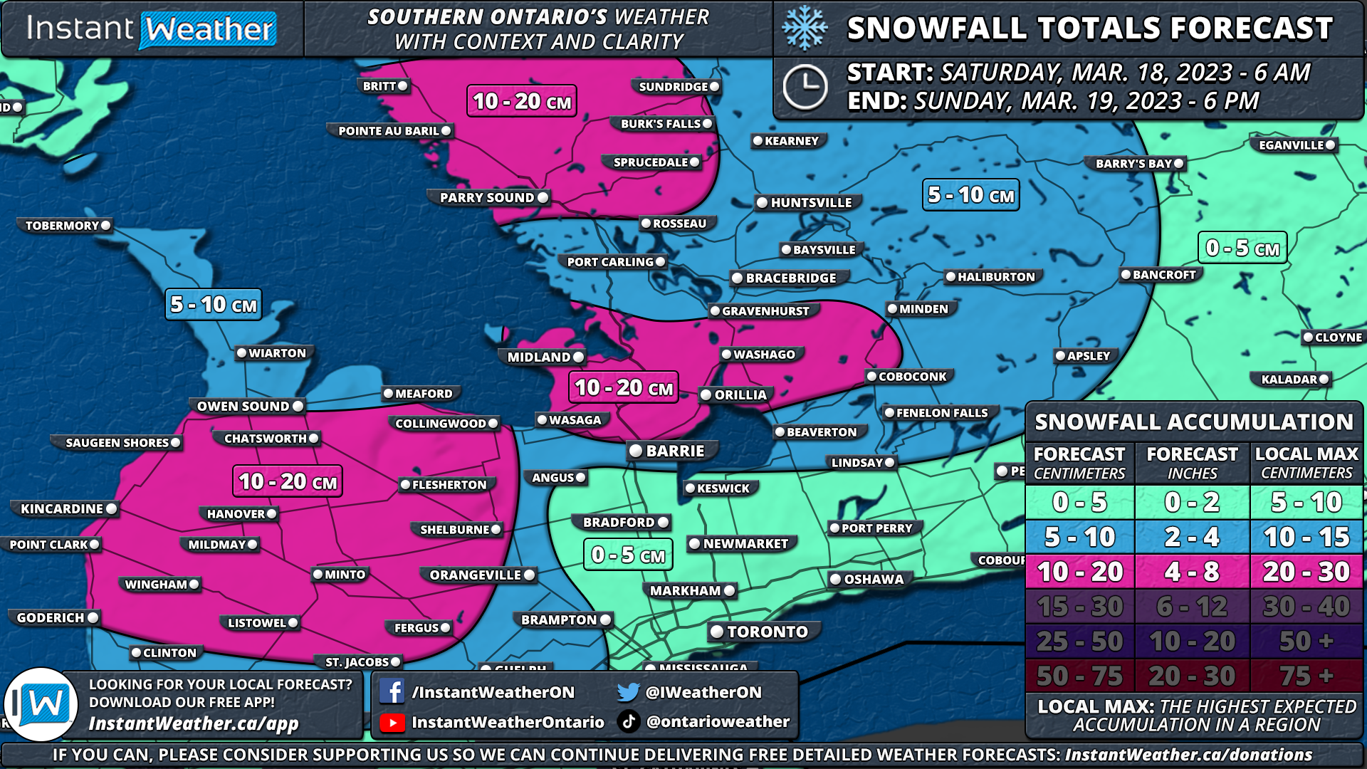
Prepare for a snowy and blustery weekend as snow squalls are set to develop east of Lake Huron and Georgian Bay. Early Saturday morning, strong southwesterly winds will form two snow squall bands – one off Lake Huron, stretching from Kincardine to Meaford, and another impacting areas northwest of Georgian Bay, such as Parry Sound, Britt, Sundridge, and surrounding communities.

As the day progresses, watch for these bands to shift southward, thanks to northwesterly winds. Grey-Bruce and Simcoe counties will find themselves in the crosshairs, with brief but intense pockets of heavy snow potentially drifting into the Greater Toronto Area (GTA) and Eastern Ontario during the afternoon and evening. Expect poor driving conditions in traditional snowbelt regions.

Snowfall totals will vary across the region. Hard-hit areas, including Grey-Bruce counties, Midland, Wasaga Beach, Orillia, Parry Sound, Britt, Sundridge, and nearby communities, can expect 10-20cm, with local accumulations up to 25cm. Central and Southwestern Ontario, as well as the western GTA, such as Kitchener-Waterloo, Guelph, and Mississauga, will likely see 5-10cm. The City of Toronto, Eastern Ontario, and Deep Southwestern Ontario are predicted to receive less than 5cm.

By Sunday morning, warmer temperatures will help ease the snow squalls, but not before they leave their mark.


Here is an advertisement so we can pay the bills:

Snowstorm Takes Aim at Northern Ontario Starting Thursday With Up to 30-50cm of Snow Possible

NOTE: You can click on the map to open a zoomable image which will be easier to read.

Forecaster: Brennen Perry

Published: Thursday, March 16, 2023


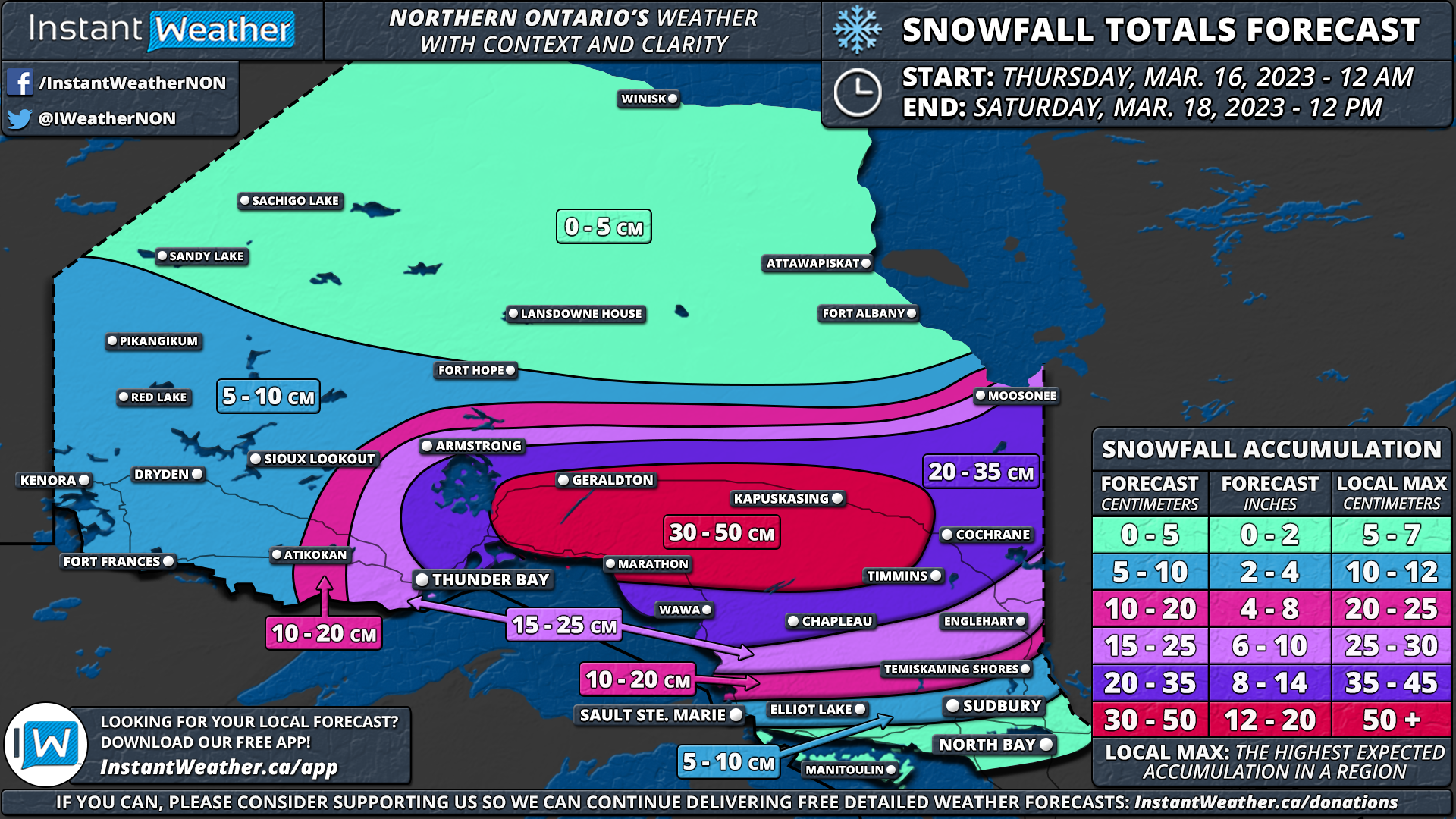
March has been relatively calm when it comes to the weather in Northern Ontario while Southern Ontario has experienced several winter storms. However, this pattern will change soon as a powerful system is expected to bring heavy snow to parts of Northern Ontario over the next few days. Some areas near Lake Superior, like Geraldton, Marathon, and Kapuskasing, could receive up to 50cm of snow.

The first bands of precipitation from this system will move in around Lake Superior on Thursday morning and afternoon. Most places will see heavy snow, but some rain might mix in around Sault Ste. Marie before turning into snow by evening. The snow will intensify late Thursday and continue overnight into Friday morning, with snowfall rates reaching 3-6cm per hour during the heaviest periods.

Strong winds, ranging from 50 to 70km/h, will combine with the snow to create extremely low visibility on roads. Some areas might even experience blizzard conditions, making travel nearly impossible and potentially causing road closures late Thursday and early Friday.

The snow will persist throughout Friday, though it will be less intense, with a few centimetres falling per hour. This will last until Saturday when the system is expected to leave the region by the afternoon.

The most severe conditions will impact areas from Thunder Bay to Timmins and Cochrane, with snowfall totals exceeding 20cm over two days and possibly reaching 50cm in some locations. Less snow is expected near the Manitoba border and further north, with less than 10cm forecasted.

To the south, along the Georgian Bay shoreline in areas like Elliot Lake, Sudbury, and North Bay, precipitation will be a mix of rain and snow or fully transition to rain. Snowfall accumulation will vary from trace amounts to 15cm. Southern Ontario will be affected primarily on Friday and Saturday, but it will experience heavy rain instead of snow. Rainfall totals will range from 15 to 30mm across Southern Ontario. A separate rainfall forecast will be posted on Thursday.


Here is an advertisement so we can pay the bills:

Major Nor'easter Aiming for Atlantic Canada, Bringing Heavy Wet Snow, Rain & Wind

A potent Nor’easter has been brewing off of Cape Cod, moving northward and will impact Nova Scotia over the next three days. The temperature will fluctuate between being just below freezing to just above so most of the province can expect a mix of rain and heavy, wet snow for the duration of the storm.

The snow will begin in Western Nova Scotia later this afternoon, spreading eastward into the evening. Overnight and through the day tomorrow, rain will likely mix with the snow with rising temperatures as it tracks across the Mainland. Overall, this will limit the snow accumulation with snow melting after falling.

Cape Breton will remain below 0°C, so the precipitation will fall strictly as snow throughout the day Wednesday. This is where we will also seeing heavier snowfall rates exceeding 3cm/hr driving snowfall totals to 30+cm, especially for the Highlands.

For the rest of the province on Wednesday and into early Thursday for Cape Breton, there will be some scattered light flurries mixed with some rain on the backside of the storm as it hits Newfoundland.

Winds gusts from this storm are expected to be in the 60-80km/h range, with the exception of Les Suêtes winds of 100+km/h. Combined with the heavy, wet snow building up on trees and power lines, there is the possibility for localized power outages so be prepared.

UPDATE: Friday’s Snowmaker Stronger Than Expected and Could Deliver Up to 20cm of Snow to Parts of Southwestern Ontario and Golden Horseshoe

NOTE: You can click on the map to open a zoomable image which will be easier to read.

Forecaster: Brennen Perry

Published: Thursday, March 9, 2023


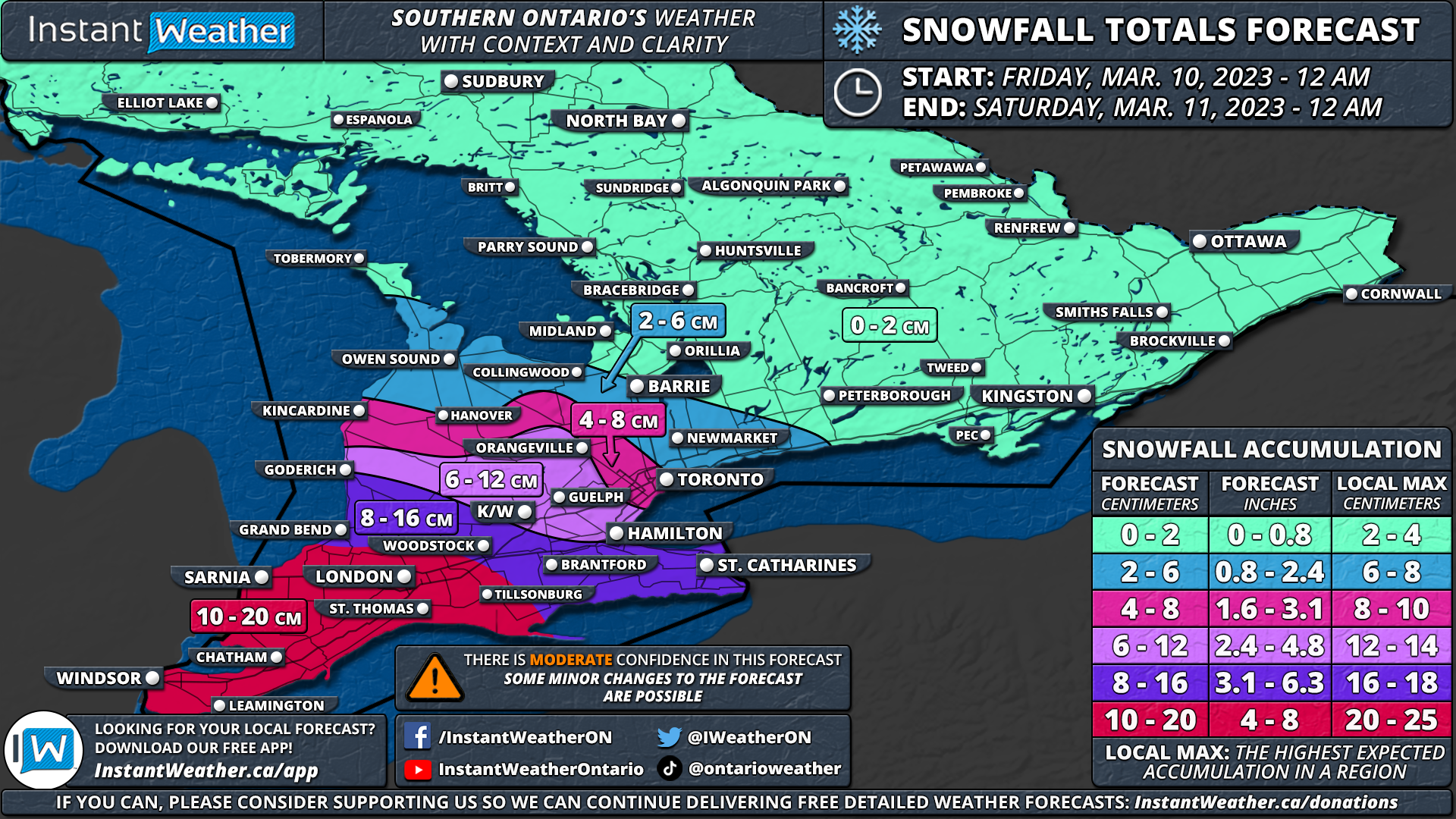
As we end yet another week with some active weather, the latest data is indicating increased snowfall totals courtesy of a system that is expected to affect Southern Ontario on Friday.

The heaviest snow will be found in Deep Southwestern Ontario including Windsor, Chatham, Sarnia and London. These areas could see between 10 and 20cm starting early Friday morning and lasting through the afternoon.

Another zone southwest of Lake Ontario including Burlington, Hamilton and Grimsby could see some lake enhancement leading to snowfall totals near 20cm.

SNOWFALL TIMING

NOTE: You can click on the map to open a zoomable image which will be easier to read.

The timing of this event is roughly unchanged from our initial forecast. We expect that the snow will begin starting in the far southwestern portion of our region during the early morning hours on Friday. Locations including Windsor and Sarnia will be the first to feel the impact of this system as it moves in from Michigan.

The heaviest snow will arrive just in time for the morning rush-hour throughout Southwestern Ontario with poor travel conditions from Windsor, Chatham, Sarnia and into London. Expect some delays and even some school bus cancellations can’t be ruled out so some children could get an early start to the March Break! More details on the chance of a ‘snow day’ will be covered in our nightly school bus cancellation forecast shortly.

By the late morning, we will start to see the initial bands of snow moving into the Golden Horseshoe bringing steady snowfall with a focus on the more western part of the region. This will continue throughout the morning and into the afternoon.

As mentioned, some locally heavier pockets of snow could develop over the higher elevations of the Niagara and Hamilton region southwest of Lake Ontario. This includes the Hamilton Mountain and Grimsby area with lake enhancement off Lake Ontario developing during the afternoon on Friday.

The snow is expected to taper off from west to east by the late afternoon and fully clear out of Southern Ontario just before the end of Friday.

SNOWFALL totals

NOTE: You can click on the map to open a zoomable image which will be easier to read.

Total snowfall accumulation will be the highest in Southwestern Ontario with a general 10 to 20cm in locations including Windsor, Leamington, Chatham, Sarnia, London and St. Thomas. Parts of the Hamilton and Niagara region could also see up to 20cm thanks to the lake enhancement off Lake Ontario. It’s even possible that some localized pockets pick up over 20cm.

The rest of Southwestern Ontario from Goderich, K/W and into the Western GTA can expect around 8-16cm of snow. There will be a very tight gradient between the higher snowfall totals and trace accumulation so confidence is a little lower in the 2-6cm and 4-8cm zones including Toronto, York Region and Barrie.

We currently think Toronto will get around 5-7cm give or take a few centimetres while totals decrease to the north. Although there is the potential for some overachieving totals depending on where the lake enhancement sets up in the GTA. Little to no accumulation will be found in Central and Eastern Ontario.


Here is an advertisement so we can pay the bills:

Yet Another End of the Week Snowstorm Could Bring Up to 10-20cm of Snow to Parts of Southern Ontario

NOTE: You can click on the map to open a zoomable image which will be easier to read.

Forecaster: Brennen Perry

Published: Wednesday, March 8, 2023


Last week at this time we were monitoring what would be an impactful snowstorm that brought blizzard conditions and up to 20-30cm of snow between Friday and Saturday. Fast forward to this week, there’s a strong feeling of déjà vu in the air as yet another snowstorm is on the horizon for Friday. Fortunately, this system isn’t expected to be anywhere near as impactful as last week’s storm and won’t be as widespread.

Current indications suggest that the heaviest snow will be found in Deep Southwestern Ontario including Windsor, Chatham, Sarnia and London. These areas could see between 10 and 20cm starting early Friday morning and lasting through the afternoon. Lake enhancement off Lake Ontario may lead to higher snowfall totals around Hamilton and Grimsby.

SNOWFALL TIMING

NOTE: You can click on the map to open a zoomable image which will be easier to read.

We expect that the snow will begin starting in the far southwestern portion of our region just after midnight. This means locations including Windsor and Sarnia will be the first to feel the impact of this system as it moves in from Michigan. There is some disagreement on the exact timing with some models suggesting a slightly later morning start although most models agree on it beginning sometime in the pre-dawn hours on Friday.

The heaviest snow will arrive just in time for the morning rush-hour throughout Southwestern Ontario with poor travel conditions from Windsor, Chatham, Sarnia and into London. Expect some delays and even some school bus cancellations can’t be ruled out so some children could get an early start to the March Break!

By the late morning, we will start to see the initial bands of snow moving into the Golden Horseshoe bringing steady snowfall with a focus on the more western part of the region. This will continue throughout the morning and into the afternoon. As mentioned, some locally heavier pockets of snow could develop over the higher elevations of the Niagara and Hamilton region southwest of Lake Ontario. This includes the Hamilton Mountain and Grimsby area with lake enhancement off Lake Ontario developing during the afternoon on Friday.

The snow is expected to taper off from west to east by the late afternoon and fully clear out of Southern Ontario just before the end of Friday.

SNOWFALL totals

NOTE: You can click on the map to open a zoomable image which will be easier to read.

Total snowfall accumulation will be the highest in Southwestern Ontario with a general 10 to 15cm in locations including Windsor, Leamington, Chatham, Sarnia, London and St. Thomas. Some models suggest even higher totals exceeding 15cm, so we’ve used a more comprehensive range of 10-20cm for our forecast map in this area.

The rest of Southwestern Ontario from Goderich, K/W, Hamilton and Niagara region can expect around 8-16cm of snow. Although the higher numbers (12-16cm) will be mostly found southwest of Lake Ontario where lake enhancement will boost totals.

Less snow is expected to the north with between 2-6cm across much of the GTA and northern parts of Southwestern Ontario. Little to no accumulation will be found in Central and Eastern Ontario.

Keep in mind that this forecast has a moderate level of confidence as there is some disagreement on the models on how far north the heavier snow will extend into our region. We may need to shift the totals up in the more northern part of our forecast zones on Thursday if models start to show a more northern track.


Here is an advertisement so we can pay the bills:
High Uncertainty With a Potential Snowmaker to Impact Southwestern Ontario on Monday

NOTE: You can click on the map to open a zoomable image which will be easier to read.

Data from pivotal weather

Forecaster: Brennen Perry

Published: Sunday, March 5, 2023


As the clean-up continues from the impactful blizzard that brought up to 30cm to parts of Southern Ontario on Friday, we are monitoring another system that has its sights set on our region to start the week. However, there is significant disagreement among the weather models with them split into two camps on how much snow it will deliver to Southwestern Ontario.

One group of models suggests this system could bring widespread accumulating snowfall with totals near 15cm in some areas between Monday evening and Tuesday morning. On the other hand, another group of models shows the system fizzling out as it enters our region leading to a few centimetres of accumulation at most in the hardest-hit regions. Models usually have a good handle on the expected snowfall accumulation within the next 24 hours, but they are struggling with this upcoming system.

Starting with the snowier group of models including the HRRR and GFS which are American weather models. They show some light snow starting to move into Southwestern Ontario near the Lake Huron shoreline by the afternoon on Monday. By the evening, heavier precipitation will move into Deep Southwestern Ontario leading to a brief heavy blast of snow from Sarnia through London and into the Niagara region. The Windsor area should stay above the freezing mark with rain being the main precipitation type so very little snowfall accumulation is expected there. Snow will continue into the overnight and pre-dawn hours on Tuesday. Although the bulk of the accumulation will come during the evening hours on Monday making for a potentially messy evening commute.

As for the overall snowfall accumulation, if this scenario verifies then we could be looking at widespread totals ranging from 10 to 15cm in the Sarnia, London, Hamilton and Niagara regions. Accumulation will drop off quite fast to the north with locations such as Barrie and Toronto picking up a few centimetres of fresh snow by Tuesday morning.

NOTE: You can click on the map to open a zoomable image which will be easier to read.

Data from pivotal weather

The other group of models which includes the NAM (American), European and Canadian models show significantly less snow. All the models agree on the general location and afternoon snowfall. However, this group shows the heaviest bands of precipitation shifting south of our region over Ohio and Pennsylvania. As a result, snow will end by the dinner hour instead of early Tuesday morning leading to a lesser impact on the evening commute.

Total snowfall accumulation will range from 2-5cm at most with Sarnia and London seeing the highest totals. For most of Southwestern Ontario, they would only see a dusting of snow compared to the widespread 10-15cm of snow suggested by the other models.

What scenario is most likely? We would lean towards the models showing less snow as they include the more high-resolution models and is the solution favoured by a slight majority of the models. However, the snowier solution can’t be completely ruled out as several models have consistently shown it and it isn’t just one outlier. We will continue to monitor the latest data and hopefully, the models can settle on one consensus with this evening's model run and then we can put together a forecast with more confidence. Stay tuned!


Here is an advertisement so we can pay the bills:

UPDATED: Significant Blizzard to Hit Southern Ontario on Friday and Saturday; Up to 25-40cm of Snow Possible

UPDATED fORECAST

NOTE: You can click on the map to open a zoomable image which will be easier to read.

Forecaster: Brennen Perry

Published: Friday, March 3, 2023


Based on the latest data, we have made some slight adjustments to our snowfall forecast for Friday into Saturday. For most regions, this means that the expected snowfall totals have increased compared to our previous forecast. With intense snowfall rates approaching 5-10cm/hour at the height of this storm by Friday night, it’s almost guaranteed to have a crippling impact on travel across much of Southern Ontario. Strong wind gusts developing tonight and lasting into Saturday morning could reach up to 60-90km/h leading to blizzard conditions and near-zero visibility.

It can’t be repeated enough: DO NOT TRAVEL TONIGHT OTHER THAN FOR ESSENTIAL PURPOSES!! Please let road crews and emergency officials do their job tonight and stay off the roads. Highway closures even in urban areas including the GTA can’t be ruled out similar to what we saw during the blizzard in January 2022.

From Environment Canada’s latest updated Winter Storm Warning for the GTA;

“Significant winter storm with dangerous travel conditions expected tonight. Non-essential travel strongly discouraged.

NOTE: You can click on the map to open a zoomable image which will be easier to read.

High-resolution models consistently show a fairly expansive zone encompassing much of the Golden Horseshoe from Hamilton through the GTA and into Kingston getting the worst of this storm. Snow will quickly pile up starting in the early evening with heavier bands of snow affecting the region by midnight. While 25-40cm may seem like an average to slightly above average snowstorm for most, the important aspect of this event is that it will come within such a short timeframe. If we get the 5-10cm hourly snowfall rates some models are suggesting, it would only take a few hours to get the forecasted amount. This isn’t a multi-day or even 24-hour snowfall event which would give road crews time to keep the main roads cleared. This will be impossible to keep up with the rapid snowfall accumulation.

There are strong indications of this storm ‘overachieving’ based on the latest data hence why we’ve increased the maximum expected snowfall accumulation from 20-35cm to 25-40cm. This may even still be too low so some areas could approach our ‘local max’ as indicated on the legend. Especially considering that this system will be further enhanced by Lake Ontario which can be hard to nail down in advance. Thundersnow is also quite possible so don’t be surprised to see some lightning with the snow tonight!

NOTE: You can click on the map to open a zoomable image which will be easier to read.

The forecast gets tricky further south along the Lake Erie shoreline. Models are having a hard time handling the potential for mixed precipitation in Deep Southwestern Ontario. Depending on how much mixing with ice pellets and rain occurs, it could lead to substantially less snowfall accumulation. But on the other hand, if it stays all snow then we could be looking at 20+cm for locations such as Windsor, Chatham and Port Colborne. We’ve lowered the expected accumulation to 5-10cm directly along the Lake Erie shoreline with closer to 10-15cm further north in Windsor and Chatham.

In Eastern and Central Ontario, we’ve increased the snowfall totals there as well because the system is expected to have more moisture to work with on its northern flank. This will allow for widespread snowfall accumulation of 10-25cm across Muskoka, Bancroft and into the Ottawa Valley. Less snow is still expected the further north you go, with less than 5cm of snow in Northeastern Ontario.


PREVIOUS fORECAST

NOTE: You can click on the map to open a zoomable image which will be easier to read.

Forecaster: Brennen Perry

Published: Thursday, March 2, 2023


The concern is growing for what could be the most impactful system we’ve seen in Southern Ontario since last January when a potent blizzard left many stuck in widespread snowfall totals of 30-50cm. This upcoming storm has some similarities in terms of intensity and impacted areas compared to the January 2022 storm, but will likely fail to reach the 50+cm snowfall totals we saw last year. As we end off the first (partial) week of ‘meteorological spring’, it certainly won’t feel like that across Southern Ontario with an approaching system from the southwest expected to move into our region starting Friday afternoon.

Current indications suggest that this system will deliver a significant dumping of snow across a wide swath of Southern Ontario including Southwestern Ontario, the Golden Horseshoe and into Eastern Ontario. Combined with strong wind gusts near 60-80km/h and intense snowfall rates, conditions will quickly deteriorate during the evening on Friday and continue overnight, into Saturday morning.

Travel will be near impossible in the affected region from 6 PM on Friday and into pre-dawn on Saturday due to near-zero visibility and rapid snow accumulation. This may even lead to several highway and road closures around the Golden Horseshoe and into Southwestern Ontario where the worst conditions are expected. If you can, please stay off the roads starting Friday evening!

There is some disagreement amongst the models on the exact snowfall totals with some differing on the track which could lead to more ice pellets mixing in along the Lake Erie and Lake Ontario shorelines. As a result, we may need to make some adjustments to the forecast by Friday afternoon based on the latest data. Either way, we are looking at a very impactful storm across Southern Ontario.

NOTE: You can click on the map to open a zoomable image which will be easier to read.

The first effects of this storm will be felt in Deep Southwestern Ontario with bands of light to moderate snowfall moving into the region just after the noon hour. Heavier snow will begin to build into Southwestern Ontario by the mid to late afternoon which is when we also expect to see the wind start to pick up.

Blowing snow and localized blizzard conditions are expected by the late afternoon in Southwestern Ontario. The temperature gradient will be extremely tight meaning some areas near the Lake Erie shoreline could mix in some ice pellets and rain later on Friday which would reduce the overall snowfall totals in the Windsor, Leamington and Chatham regions.

As we head into the dinner hour on Friday, this storm will encompass much of Southwestern Ontario as it approaches the Golden Horseshoe. Conditions are expected to quickly deteriorate just after 6 PM across the Golden Horseshoe as the snowfall rate rapidly increases from a few centimetres per hour in the late afternoon to 3-6cm/hour by the early evening.

Treacherous conditions will continue throughout the evening and into the early overnight hours with the most intense snowfall rates just before midnight. Most of the snow from this storm will come during a 6-12 hour timeframe which is expected to further enhance the impact due to blowing snow as road crews are unable to keep up with the intense snowfall rates.

For Central and Eastern Ontario, there is some disagreement on exactly how far north the bands of snow will make it into our region. Some models show a tighter gradient with the heavy snow which would lead to lighter snow for the more northern parts of Southern Ontario. The snow is expected to start by the early evening (late evening in the Ottawa Valley) and continue steadily overnight into Saturday morning.

Conditions should begin to improve by the mid to late morning on Saturday as the system exits our region. Although keep in mind that many roads will likely still be snow-covered and it could take a good portion of the weekend before everything is fully cleaned up so expect some lingering impacts throughout Saturday.

NOTE: You can click on the map to open a zoomable image which will be easier to read.

In terms of the worst impact, we expect blizzard conditions to be quite widespread affecting Sarnia, London, Hamilton, K/W, GTA, Barrie, Peterborough and Kingston. Wind gusts ranging from 50-80km/h combined with the heavy snow will lead to whiteout conditions mainly between 5 PM and 2 AM on Friday. Those near the Lake Erie shoreline and into the Niagara region could mix in some ice pellets leading to lower snowfall accumulation although a moderate impact is still expected.

While the focus of this event won’t necessarily be on the total accumulation, it will certainly be an important component. Current data suggests the highest totals will be found right around the Golden Horseshoe thanks to potential lake enhancement off the western shoreline. As such, much of the GTA and into Southeastern Ontario is on track to see between 20-30cm with maybe as much as 35-40cm in some pockets.

The more extreme totals will likely be found in the higher elevations away from the shoreline including the Dundalk Highlands (Orangeville, Guelph etc.) and just north of the GTA around Vaughan and Richmond Hill. Those near the shorelines including Toronto, Hamilton, Burlington and Oshawa will pick up closer to 20cm (or even less if we see some mixing occur).

General snowfall totals in Southwestern Ontario will range from 15 to 25cm including Sarnia, London and Goderich. The slightly lower totals are due to the potential for ice pellets along with the snow expected to be denser as temperatures will be close to the freezing mark leading to lower liquid-to-snow ratios. Between 10 to 20cm is expected along the Lake Erie shoreline in Deep Southwestern Ontario and could even end up lower than 10cm should temperatures end up warmer than expected and result in a switchover to rain.

As we have mentioned, there is a significant disagreement on the totals through Central and Eastern Ontario. Some models suggest that the Ottawa region could pick up close to 20-25cm while others show less than 10cm so there is a lot of variance in the numbers. At this point, we’re going with a widespread 10-20cm although the potential is there for up to locally 25cm. Once you get into the more northern sections of Southern Ontario including Muskoka, Bancroft and Pembroke, we are looking at around 6-12cm of snow possible although this area may fail to see much snow should the precipitation stay further south.


Here is an advertisement so we can pay the bills:

Potential Late-Week Snowstorm Could Bring Over 20cm of Snow and Blizzard Conditions to Southern Ontario

NOTE: You can click on the map to open a zoomable image which will be easier to read.

Forecaster: Brennen Perry

Published: Tuesday, February 28, 2023


While Wednesday marks the first day of meteorological spring, Mother Nature has other plans with yet another impactful storm on the way. Our concern for this system has continued to grow over the past few days as models consistently point towards a potential significant snowfall across a wide swath of Southern Ontario. It appears the snow will start midday on Friday and continue overnight into Saturday. Strong wind gusts approaching 50-80km/h could lead to blowing snow and even blizzard conditions in some areas.

The tricky part with this system is narrowing down the exact path which dictates who gets the highest snowfall totals. We are still several days away and models have been split into two scenarios. So far the most consistent scenario currently shared by the American and Canadian models (with the Canadian slightly more south) has the centre of the low-pressure tracking south of Lake Erie. This would mostly keep our region on the colder side of the system, leading to predominantly a heavy snowfall event. 

As shown on our first map above for Scenario #1, the highest snowfall totals would extend from Lake Huron through the GTA and into Southeastern Ontario. While we aren’t going to get too specific about snowfall totals as it’s too early, we can say there is a good chance those regions will see well over 20cm of accumulation in this scenario. The American model (GFS) has been particularly aggressive regarding snowfall totals showing widespread 30-40cm which would be very significant. This is more of the worst-case scenario, but it’s important to mention, as it can become a reality which we saw last winter.

For Deep Southwestern Ontario and the Niagara region, they will see a mix of mainly ice pellets and snow along with some freezing rain. They could also see significant snowfall accumulation, but confidence is lower due to the potential for ice pellets reducing the overall totals. Less snow will be found to the north across Central and Eastern Ontario. Although there is some disagreement on the exact location of the cut-off of the extreme northern edge of this system. Expect up to 10-15cm in the more southern sections of Central and Eastern Ontario, slowly dropping off closer to 5cm as you get further north.

NOTE: You can click on the map to open a zoomable image which will be easier to read.

On the other hand, the European model has been suggesting a different scenario that has the system further to the north. A more northern track takes the centre of the low pressure to the north of Lake Erie. As a result, this would put the heaviest bands of snow over Central and Eastern Ontario which we’ve outlined in our map for Scenario #2. While those in Southwestern Ontario and along the Golden Horseshoe see a messy mix of snow, ice pellets, freezing rain and rain as they end up right on the line between the cold and warm air.

This would be quite similar to the last few events we have seen across Southern Ontario, however, it does appear there will be less of a freezing rain component to this storm. The main precipitation types will be snow, ice pellets and even rain depending on which scenario wins out. There will be more moisture for this system to work with as it taps into the Gulf of Mexico and will be overall stronger based on the pressure. So the impacts of this storm will likely differ compared to the past few storms and likely not in a good way.

Strong wind gusts combined with intense snowfall rates will lead to blinding whiteouts at the height of this event and may even result in some road/highway closures late Friday into Saturday. There could be a significant impact on the evening commute on Friday depending on the exact timing. It’s right on the fence and hopefully is delayed by a few hours to push the worst impact into the overnight hours when fewer people are on the roads.

Again, lots can change between now and Friday, but the confidence is slowly growing in some form of an impactful winter storm across Southern Ontario to end the weekend. Somewhere in Southern Ontario is going to likely see over 20cm between Friday and Saturday. This isn’t a guarantee that a specific location will see a major snowfall. The potential is there which is our focus - we want you to be prepared for the worst, but hope for the best! We will continue to monitor each new set of model data and provide more precise details throughout the week. Stay tuned!


Here is an advertisement so we can pay the bills:

February Set to Go Out Like a Lion as Southern Ontario Is Targeted by Another Winter Storm on Monday

Updated forecast

NOTE: You can click on the map to open a zoomable image which will be easier to read.

Forecaster: Brennen Perry

Published: Sunday, February 26, 2023


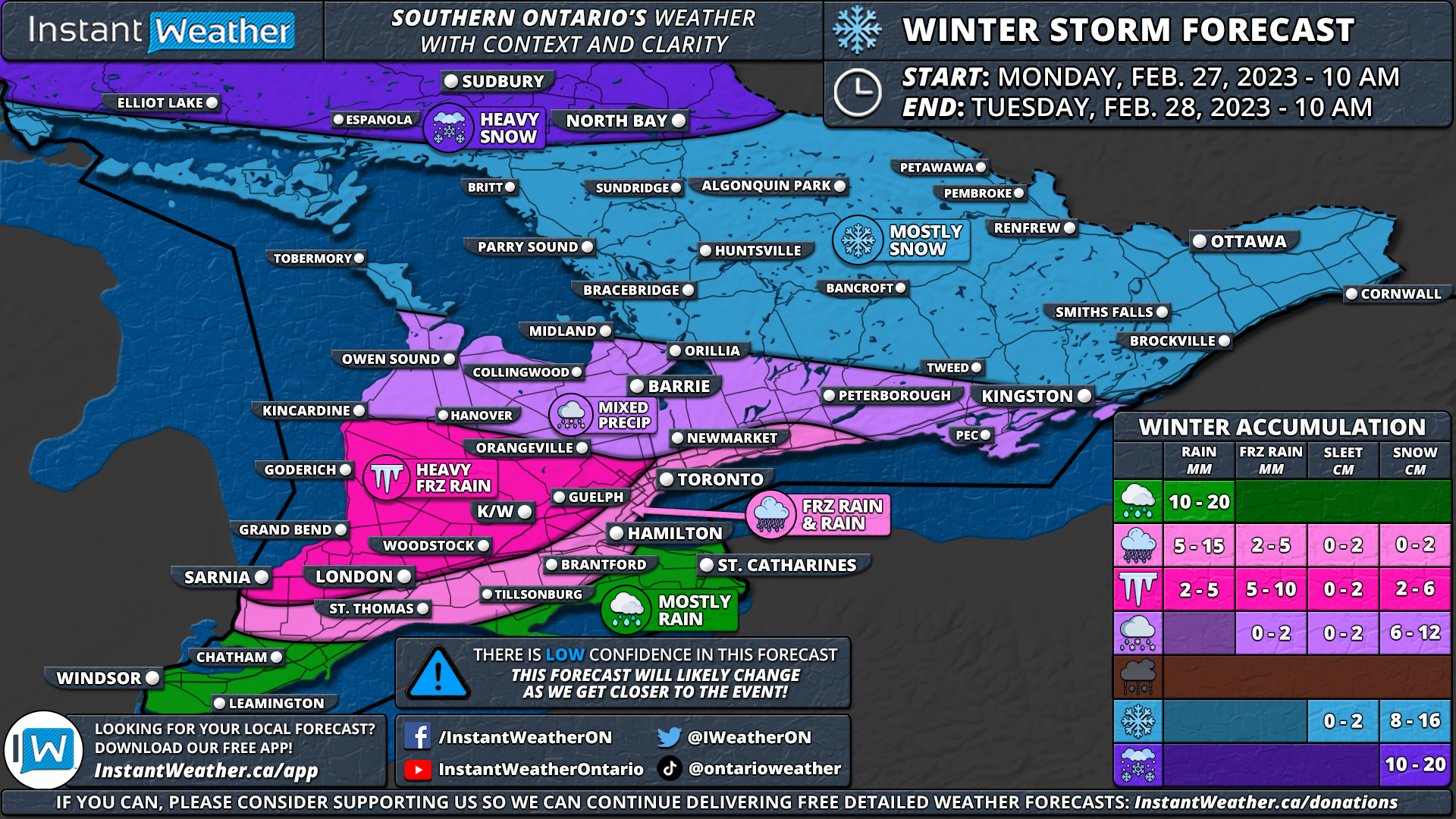
Déjà vu, anyone? After reviewing the latest model data on the upcoming system for Southern Ontario, it looks like the colder air will win over across much of the region. We have adjusted our forecast moving the heavy snow zone further south into Central and Eastern Ontario. The freezing rain risk now covers an almost identical area as last week's storm with the heaviest icing expected across Sarnia through London and into the Hamilton/Niagara region. For the rest of Southwestern Ontario and into the GTA, we are looking at a mixed bag of precipitation including brief freezing rain, ice pellets and snow.

The timeframe of this winter storm is fairly similar to our initial forecast with precipitation expected to start during the late morning hours in Deep Southwestern Ontario and spreading northward throughout the afternoon. It will likely begin as freezing rain in the Windsor/Chatham region before transitioning over to rain as temperatures rise above the freezing mark by the dinner hour. As mentioned, those in the Sarnia, London and Hamilton corridor will see more prolonged freezing rain during the afternoon and evening where the cold air is expected to hold on.

We are also looking at a big impact on the evening commute as heavy snow and ice pellets affect the Golden Horseshoe starting during the late afternoon and continuing through the evening. There is still some disagreement on the exact temperature in this area, especially closer to the shoreline of Lake Ontario which would dictate the main precipitation type. Current indications suggest it should start as some heavy wet snow before transitioning over to ice pellets and even some freezing rain. Later in the evening and overnight, there is the potential that temperatures climb above the freezing mark around the shoreline leading to a transition over to rain.

For Central and Eastern Ontario, snowfall will start during the early evening hours, continuing throughout the overnight and into Tuesday morning. Strong to damaging wind gusts may also accompany this system with gusts expected to reach 60-80km/h by late Monday and may even come close to 90km/h east of Lake Huron. This could lead to power outages in the areas that received heavy freezing rain earlier in the day and blowing snow for those further north.

Everything will come to an end by Tuesday afternoon as the system moves out of our region. Total snowfall accumulation across Central and Eastern Ontario is expected to range from 10 to 15cm with some localized pockets (especially in the Ottawa Valley) picking up to 20cm. The icing from this event isn't expected to come near what we saw last week, but up to 4-8mm of ice accretion is possible in the hardest-hit region. Those in between the snow and freezing rain including much of Southwestern Ontario into the GTA will see a bit of everything so the exact totals are difficult to predict depending on the exact temperature.


PREVIOUS fORECAST

NOTE: You can click on the map to open a zoomable image which will be easier to read.

Forecaster: Brennen Perry

Published: Saturday, February 25, 2023


It has certainly been an active month across Southern Ontario regarding the weather as we’ve experienced almost all the seasons over the past few weeks. This includes temperatures on both extremes from wind chills in the -30s to spring-like temperatures well into the teens. It shouldn’t be a surprise that February is set to conclude with a bang across our region as yet another messy winter storm is on the horizon for Monday into Tuesday. Impacts will vary across the region from heavy snow in Central and Eastern Ontario to potentially several hours of freezing rain in the south.

There is still some uncertainty regarding the exact intensity and timing of this storm so it’s quite likely there are some changes to the forecast as we get closer to Monday. At this point, it appears precipitation will start during the late morning or early afternoon on Monday in Deep Southwestern Ontario. With temperatures expected to be just above the freezing mark in the Windsor/Chatham area, it should come down in the form of rain. Total rainfall accumulation throughout this event will range from 10-20mm.

As the precipitation spreads further north throughout the afternoon it will encounter some colder temperatures east of Lake Huron and into the Golden Horseshoe. As a result, a fairly expansive zone of freezing rain will develop and impact Sarnia, London, Goderich, K/W and Guelph along with parts of the GTA away from the shoreline throughout the afternoon and early evening. This could lead to icy road conditions just in time for the evening commute on Monday so plan to leave extra time to get to your destination and drive according to the conditions!

The forecast gets tricky for those in the GTA around the Lake Ontario shoreline and into the Niagara region as temperatures will be very close to the freezing mark. Brief freezing rain is possible before it slowly transitions over to rain although if this transition is slower then more icing is possible. The Niagara region will likely see minimal freezing rain as the temperature is expected to rise faster there compared to other areas.

While this system isn’t expected to be as significant as last week’s storm that brought heavy ice accretion from freezing rain, the timeframe will be very similar as we see the worst impacts primarily during the evening across Southwestern Ontario and the Golden Horseshoe. Freezing rain will begin to transition over to rain in Southwestern Ontario as the temperature slowly climbs above the freezing mark during the evening and early overnight.

Total ice accretion could range from 5-10mm in the hardest hit regions, but this should melt away fairly quickly unlikely last week which would limit the overall impact. It may still result in some localized power outages with a thin layer of ice developing on untreated surfaces including trees and power lines.

Further north across Central and Eastern Ontario, we are looking at mostly snowfall with ice pellets mixed in for regions south of Lake Simcoe. Snow will start during the late afternoon and continue throughout the evening and overnight. Total snowfall accumulation is expected to range from 6 to 16cm with the highest totals in the more northern parts of our region. Those in Northeastern Ontario including Elliot Lake, Sudbury and North Bay could see up to 20cm of snow. We expect to see the snow come to an end by the noon hour on Tuesday.

As mentioned, this is a preliminary forecast as there is some uncertainty on how long the cold temperatures will hold on which would affect the overall ice accretion. There is more confidence in the snowfall portion of this event so if we make any changes, it will likely be in Southwestern Ontario and the Golden Horseshoe once we get a better idea of how quickly the switchover will occur. Check back on Sunday for a more detailed forecast.


Here is an advertisement so we can pay the bills:

Major Ice Storm Targets Southern Ontario Starting Wednesday & Significant Snowstorm for Central and Eastern Ontario

Forecaster: Brennen Perry

Published: Tuesday, February 21, 2023


While this month has been a roller coaster when it comes to the weather across Southern Ontario, we are heading back to winter as a major winter storm targets our region over the next few days. This will come in the form of prolonged freezing rain for Southwestern Ontario, ice pellets across the GTA and heavy snow in Central and Eastern Ontario. Precipitation is expected to start Wednesday morning lasting into Thursday. The storm will have a significant impact to travel across Southern Ontario and widespread power outages are likely in the region that sees freezing rain.

Initial bands of precipitation associated with this system are expected to reach the Canadian border in Deep Southwestern Ontario from Michigan around the noon hour. It will likely start as some light snow mixed with ice pellets before changing over to ice pellets and freezing rain by the early afternoon. Snow will also spread further to the northeast, reaching Southwestern Ontario and the GTA by the mid-afternoon. This will lead to rapid snowfall accumulation over the afternoon before it transitions over to ice pellets.

Conditions will continue to progressively worsen into the evening with intense icing ongoing from Sarnia through London and into Hamilton right at the height of the rush hour. Heavy ice pellets will be a concern throughout the GTA mixed in with snow and some freezing rain. Snow will start to affect Central and Eastern Ontario by the late evening continuing overnight. Some parts of Deep Southwestern Ontario including Windsor, Chatham and along the Lake Erie shoreline may inch above the freezing mark overnight which would reduce the freezing rain impact.

Conditions will be very treacherous starting from Wednesday late afternoon and into the predawn hours on Thursday. Travel should be avoided if possible until continues to improve later Thursday. Especially in the area expecting significant ice accretion with a thick layer of ice developing on untreated surfaces.


Here is an advertisement so we can pay the bills:

SPONSORED - NOT ENDORSED BY INSTANT WEATHER


Strong winds gusting between 60-80km/h are also expected by the evening on Wednesday and continuing overnight. This will further enhance the impact of both the freezing rain leading to power outages and blowing ice pellets/snow or even localized blizzard conditions in areas further north.

Precipitation will slowly taper off from west to east beginning just after midnight. So the worst of the freezing rain will be finished by the early morning hours on Thursday. While snow will continue across Central and Eastern Ontario throughout the morning.

Another round of precipitation will move across our region during the afternoon on Thursday bringing patchy freezing rain throughout Southwestern Ontario and the GTA. Further north, we will see ice pellets or light snow across Central and Eastern Ontario during the afternoon and evening.

As the system finally exits our region by late Thursday, it will usher in much cooler air in time for the weekend. Morning lows on Friday could dip into the -20s for some parts of Southern Ontario!

NOTE: You can click on the map to open a zoomable image which will be easier to read.

When it comes to the overall ice accretion and snowfall accumulation, the forecast becomes tricky as it will depend on the exact surface temperature. Even if the temperature is a fraction of a degree colder or warmer than expected, it could mean the difference between heavy freezing rain and rain or ice pellets. As such, it’s important to focus on the overall impact which is expected to be similar no matter if you see freezing rain, ice pellets or snow.

With that being said, we believe the hardest-hit area when it comes to the freezing rain will extend from Sarnia through London and into Woodstock. This zone could pick up to 15-30mm of ice accretion, but this will depend on the surface. For Windsor and Chatham into the Hamilton/Niagara region, ice accretion is expected to range from 6-12mm and maybe up to 15mm in localized pockets (especially in more elevated regions like the Hamilton Mountain). Less freezing rain is expected the further north you go as we see more ice pellets and snow across the GTA and Central/Eastern Ontario.

NOTE: You can click on the map to open a zoomable image which will be easier to read.

The focus on the snow will be in Eastern Ontario where the Ottawa Valley is likely to see 25-40cm of accumulation by the end of Thursday. It should be noted that some models are showing less moisture making that far north so the potential for this region to underperform the forecast isn’t out of the question. For the rest of Eastern and Central Ontario, snowfall totals will end up somewhere around 15-30cm.

As we go south of Lake Simcoe the snowfall accumulation will become less clear as ice pellets mix in and reduce the overall snow total. We are looking at 10-20cm from Goderich and into the Toronto region although that could end up on the lower end due to the ice pellets. And less than 10cm of snow is expected through Deep Southwestern Ontario and north of Lake Erie where freezing rain is the concern.


Here is another advertisement so we can pay the bills:

SPONSORED - NOT ENDORSED BY INSTANT WEATHER

Potential Snow and Ice Storm Threatens to Bring Significant Disruptions Across Southern Ontario Starting Wednesday

NOTE: You can click on the map to open a zoomable image which will be easier to read.

Forecaster: Brennen Perry

Published: Sunday, February 19, 2023


The concern is growing over a system expected to affect Southern Ontario as early as Wednesday afternoon and continuing into Thursday. The two main stories expected to dominate with this system’s impact on our region will be the heavy snow to the north and prolonged freezing rain to the south. Total snow accumulation could approach 20-30cm in the hardest-hit locations by the end of Thursday. Significant ice accretion is possible in the areas that see freezing rain with up to 10-25mm of accretion.

Where the mixing line is located will dictate who sees what in terms of precipitation. Most of the latest models agree on a rough track that could put much of Southern Ontario on the snow side of the storm north of a line from Goderich and Toronto. Those closest to the mixing line will experience a mix of ice pellets and snow with total accumulation ranging from 10-20cm including both snow and ice pellets. And further to the north including Central and Eastern Ontario, we are expecting snow to be the main concern with up to 15-30cm of accumulation possible. Do note that there is some uncertainty on how far north the moisture associated with this system will get. So it’s possible that if the system tracks further to the south, those in the far north of our forecast region including Sudbury, North Bay, Algonquin Park and Ottawa will see lower snowfall totals.

Meanwhile, those to the south including Windsor, Sarnia, London, K/W, Hamilton and Niagara will see a mix of ice pellets and heavy freezing rain. This freezing rain could be quite persistent lasting from Wednesday evening through to Thursday afternoon. Almost 12-16 hours of freezing rain will surely lead to a significant impact in the affected regions including making travel near impossible and potential power outages! This will also be followed by some strong to damaging winds late Thursday into early Friday which could lead to even more damage from ice-covered surfaces.

As this storm is still several days away, we can’t get into too many details on the exact timing as that will likely shift around as we get closer to Wednesday. However, it appears likely that the worst conditions will occur during the evening and overnight hours on Wednesday continuing into Thursday. As a result, expect bad travel conditions for the evening commute on Wednesday and the morning commute on Thursday. This will almost certainly lead to widespread school bus cancellations for Thursday.

We will be closely following the latest data over the next few days and will have a more detailed forecast including exact timing and accumulations. As mentioned, there is still plenty of time for the models to change so expect to see at least some changes in terms of location and overall accumulation. We hope this does change as the current scenario doesn’t look good on the effects it could have on Southern Ontario.


Here is an advertisement so we can pay the bills:

Freezing Rain Threat Across the Province Friday Afternoon and Evening

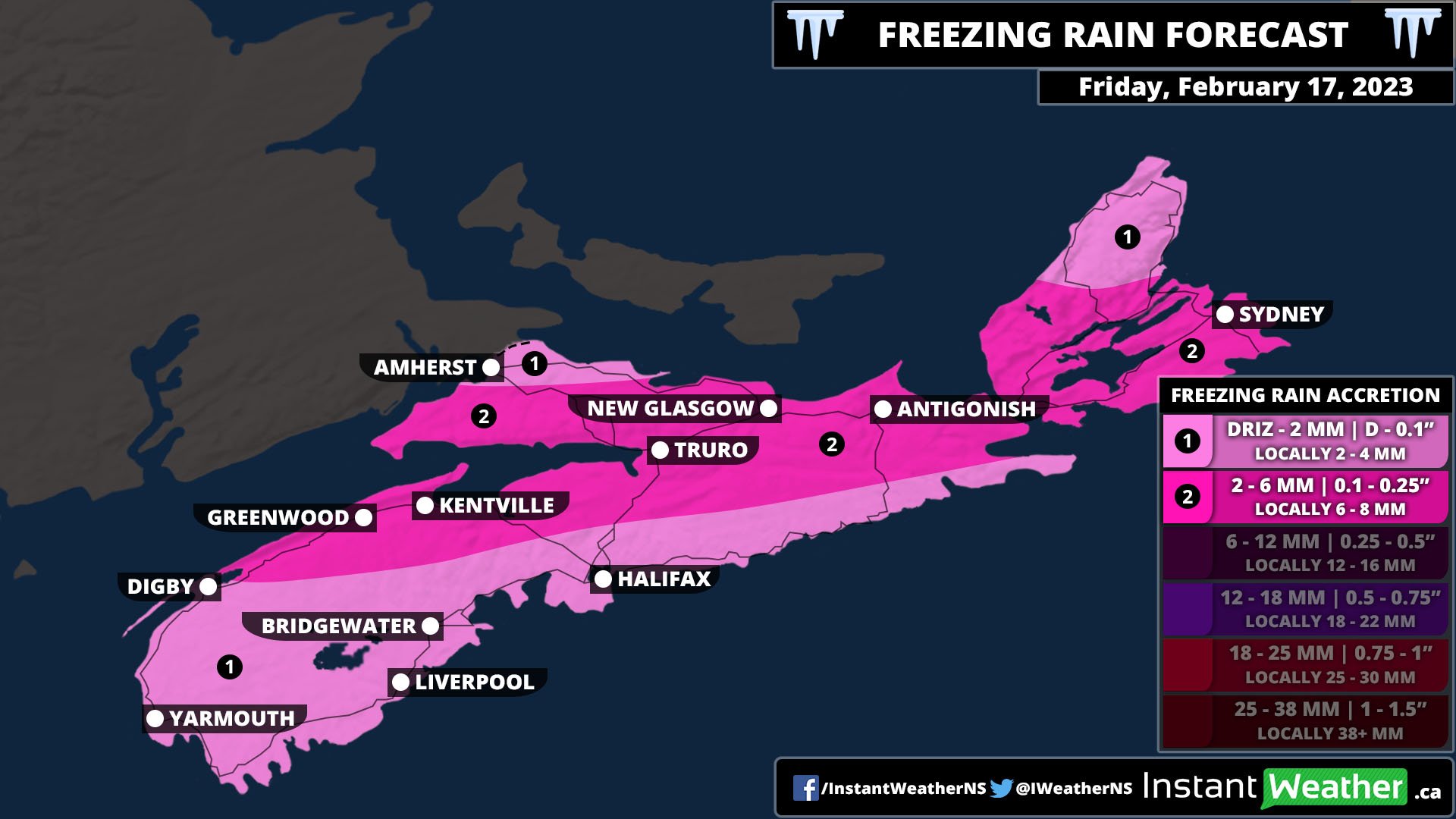
The latest winter storm to hit Nova Scotia will move in from the west beginning tomorrow morning. It will start off with snow and ice pellets for Northern Nova Scotia and Western Cape Breton Island and rain for the Annapolis Valley and South Shore. By the early afternoon, a considerable band of freezing rain will develop, replacing the snow as the temperature rises and approaches the freezing mark. The most prolonged freezing rain will occur from Digby through to Eastern Cape Breton Island and northward. This region could see up to 6mm, or 0.5”, of ice buildup on surfaces from this storm. South of this line, rain will fall for most of the day, but the band of freezing rain will push southeastward, resulting in a transition of precipitation type later in the afternoon and into the evening as the temperature falls. The storm will continue to track southeast overnight and into the morning, with the freezing rain followed by ice pellets and then snow before clearing up.

The northern tip of Cumberland County and the Cape Breton Highlands may see trace amounts of freezing rain from this event, but will mostly see snow and ice pellets. In the Highlands, up to 30cm of snow and ice pellets is possible, while the rest of Cape Breton Island will be in the 10-15cm range. Most of the rest of the province can expect 5-10cm of snow and pellets, with the exception of Cumberland County and the Northumberland Shore where the snow starts early tomorrow and will persist with ice pellets in some areas.

With the risk of freezing rain, ice buildup becomes a concern with untreated surfaces as well as on tree limbs and power lines. Wind gusts throughout the day will be 30-50km/h so it won’t be a major ice storm by any means, but there still may be some power outages across the province.

Freezing Rain Threat Looms for Southern Ontario on Thursday With a Potential Flash Freeze on Friday

NOTE: You can click on the map to open a zoomable image which will be easier to read.

The rollercoaster of seasons across Southern Ontario continues as we end another week with a potentially messy winter storm. We’ve been treated with fairly mild weather making many think that spring is here - even the rodent weather prognosticator! But we are in Canada after all and winter is far from done with our region.

And that blast of reality is under 24 hours away as we see the risk of prolonged freezing rain across a large swatch of Southern Ontario along with heavy sleet and snow starting Thursday afternoon. It will be followed by a rapid cooldown on Friday morning bringing temperatures well below the freezing mark in time for the weekend. The fact that the extended freezing rain will be followed by a deep freeze is concerning as usually, we see a rise in temperature allowing for any ice to quickly melt. That won’t be the case this time which could lead to longer-lasting impacts including damage from the ice and power outages.

Precipitation will start just after the lunch hour in Deep Southwestern Ontario. For the most part, it looks like freezing rain will be the predominant precipitation type. However, the temperature could be slightly above the freezing mark, especially along the Lake Erie shoreline leading to less freezing rain. May also see some ice pellets further north for regions east of Lake Huron and even some wet snow for the Grey-Bruce region.

The band of freezing rain will continue to expand to the northeast across the Golden Horseshoe by the late afternoon and Southeastern Ontario by the dinner hour. Again, the temperature will be a big factor in determining the overall impact making this forecast a tricky one. Currently, it looks like the cold air will win over with this system allowing for prolonged freezing rain. Although we could see less icing in areas along the shorelines including Hamilton, Toronto and the Niagara region should the temperature stay just above the freezing mark.

Ice accretion in the hardest hit regions could range from 5-10mm by early Friday morning which is when we expect to see the freezing rain come to an end. Less accretion is expected further north and along the shoreline of Lake Ontario and Erie with between 2-6mm of accretion possible.

For Central and Eastern Ontario (including the Ottawa Valley), the story with this storm will be a mix of ice pellets and snow starting Thursday evening and continuing into Friday morning. Overall accumulation here will range from 8 to 16cm of snow along with up to 2-6cm of ice pellets. Snow will come to an end by late Friday morning so expect some impact on the morning commute including possible school bus cancellations. We will have more information on that in our daily ‘snow day’ forecast here.


Here is an advertisement so we can pay the bills: