Severe Thunderstorm Risk Map For September 4th, 2017 #onstorm
InstantWeather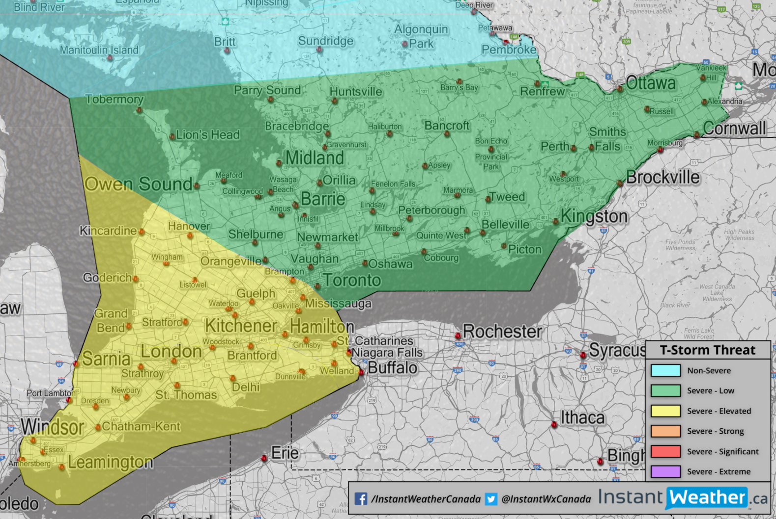
Yellow = Elevated (2/5) risk for severe thunderstorms this afternoon/evening Green = Low (1/5) risk for severe thunderstorms this afternoon/evening
A line of thunderstorms, several likely to be severe will push southeast through our region this afternoon/evening.
Damaging wind gusts are the most serious threat (downbursts/microbursts), along with flooding, hail and frequent lightning. There'a also a risk for a tornado or two, especially in deep southwestern Ontario, in areas north of Lake Erie. Latest data suggests if there is a tornado, it could be fairly strong and we'll be watching very closely this afternoon.
We may upgrade extreme southwestern Ontario and areas north of Lake Erie, and perhaps as far north as London to a Strong (3/5 Orange) risk later this afternoon. We're on the fence at this point but if we feel the risk continues to trend stronger, we will adjust the forecast accordingly.
More details ASAP.
- OTW (Adam S., Kyle D., Troy B., Kevin R., Remy M., Alannah C., Brennen P.)
P.S. We've got our coffee & banana's ready! :)
- 10th Line Shore
- Aberarder
- Aberdeen
- Aberfeldy
- Aberfoyle
- Abingdon
- Achill
- Actinolite
- Actons Corners
- Adamsville
- Adanac
- Addison
- Adelaide
- Admaston
- Adolphustown
- Agerton
- Agincourt
- Agincourt North
- Ahmic Harbour
- Ahmic Lake
- Aikensville
- Ailsa Craig
- Airlie
- Airy
- Ajax
- Albert
- Alberton
- Albion
- Albion Falls
- Albuna
- Albury
- Alcona
- Aldborough
- Alder
- Aldershot
- Alderslea
- Alderville
- Alderwood
- Aldred's Beach
- Alexandria
- Alfred
- Algonquin
- Algonquin Park
- Alice
- Allan
- Allan Mills
- Allan Park
- Allanburg
- Allans Corners
- Allen's Corners
- Allenford
- Allensville
- Allenwood
- Allenwood Beach
- Allisonville
- Alliston
- Alloa
- Allsaw
- Alma
- Almira
- Almonte
- Alpine Village
- Alport
- Alsfeldt
- Alsops Beach
- Alta Vista
- Althorpe
- Alton
- Altona
- Alvanley
- Alvinston
- Ambassador Beach
- Amberley
- Ambleside
- Ameliasburg
- Amherst Pointe
- Amherstburg
- Amherstview
- Amigari Downs
- Amigo Beach
- Amulree
- Ancaster
- Ancaster Heights
- Ancona Point
- Anderson
- Andrewsville
- Andy's Corners
- Angers
- Angus
- Annable Settlement
- Annan
- Anoma Lea
- Ansnorveldt
- Anson
- Anstruther Lake
- Anten Mills
- Antrim
- Appin
- Apple Hill
- Appleby
- Appledore
- Appleton
- Applewood Acres
- Applewood Heights
- Applewood Hills
- Apsley
- Apto
- Arbeatha Park
- Archer
- Ardbeg
- Arden
- Ardendale
- Ardmore Beach
- Ardoch
- Ardtrea
- Argyle
- Ariss
- Arkell
- Arklan
- Arkona
- Arkwright
- Arlington Woods
- Armadale
- Armbro Heights
- Armitage
- Armour Heights
- Armow
- Armstrong Mills
- Armstrongs Corners
- Arner
- Arnott
- Arnprior
- Arranvale
- Arthur
- Arthur's Corners
- Arva
- Ash
- Ashburn
- Ashburnham
- Ashby Mill
- Ashdad
- Ashdale
- Ashgrove
- Ashton
- Ashton Station
- Ashworth
- Aspdin
- Asselstine
- Assumption
- Atha Road
- Athens
- Atherley
- Atherton
- Athlone
- Athol
- Atironto
- Atkinson
- Attercliffe
- Attercliffe Station
- Atwood
- Auburn
- Auburn Mills
- Auden Park
- Audley
- Augsburg
- Aurora
- Avalon Park
- Avening
- Avery Point
- Avon
- Avonbank
- Avondale
- Avonmore
- Avonry
- Avonton
- Axe Lake
- Aylen Lake
- Aylesworth
- Aylmer
- Ayr
- Ayton
- Baby Point
- Babys Point
- Baddow
- Baden
- Badenoch
- Badger's Corners
- Badjeros
- Baelstadt
- Bagnall
- Baie du Doré
- Baie-Noire
- Bailieboro
- Bainsville
- Bala
- Bala Park
- Balaclava
- Balderson
- Baldoon
- Baldwin
- Baldwins Bridge
- Balfour Beach
- Ballantrae
- Ballinafad
- Ballycanoe
- Ballycroy
- Ballydown Beach
- Ballyduff
- Ballymote
- Balm Beach
- Balmoral
- Balmoral Park
- Balmy Beach
- Balsam
- Balsam Grove
- Balsam Hill
- Baltics Corners
- Baltimore
- Balvenie
- Bamberg
- Banbury
- Bancroft
- Banda
- Bangor Lodge
- Banks
- Banner
- Bannockburn
- Baptiste
- Bar Point
- Barb
- Barber's Beach
- Barclay
- Barcovan Beach
- Bardsville
- Barkway
- Barlochan
- Barnesdale
- Barrett Chute
- Barretville
- Barrhaven
- Barrhead
- Barrie
- Barriefield
- Barrillia Park
- Barrow Bay
- Barry's Bay
- Barrymere
- Barryvale
- Bartonville
- Basin Depot
- Basingstoke
- Baskin's Beach
- Bass Lake Park
- Bassin-du-Lièvre
- Batawa
- Bath
- Batteaux
- Battersea
- Baxter
- Baxters Corners
- Bay Beach
- Bayfield
- Bayridge
- Bayshore
- Bayshore Estates
- Bayshore Village
- Bayside
- Baysville
- Bayview
- Bayview Beach
- Bayview Park
- Bayview Point
- Bayview Village
- Baywood Park
- Beach O'Pines
- Beachburg
- Beachville
- Beacon Heights
- Beacon Hill North
- Beacon Hill South
- Beaconsfield
- Beaconwood
- Beales Mills
- Bealton
- Beamsville
- Bear Cave
- Bear Lake
- Bear Line
- Bear Point
- Bearbrook
- Beatrice
- Beatty
- Beaumaris
- Beaumonde Heights
- Beaver Dams
- Beaver Meadow
- Beaverdale
- Beavers Corner
- Beaverton
- Becher
- Becketts Bridge
- Becketts Creek
- Becketts Landing
- Beckstead
- Bedell
- Bedford
- Bedford Mills
- Bedford Park
- Beech Corners
- Beechmount
- Beechwood
- Beeton
- Bel Air Heights
- Bel Air Park
- Belangers Corner
- Belcreft Beach
- Belfast
- Belford
- Belfountain
- Belgrave
- Belhaven
- Bell Ewart
- Bell Rapids
- Bellamys
- Bellamys Mill
- Belle Air Beach
- Belle River
- Belle-eau-Claire Beach
- Belleview Beach
- Belleville
- Bellheck
- Bellrock
- Bells Corners
- Bells Crossing
- Bellwood
- Belmeade
- Belmont
- Belmore
- Belton
- Belwood
- Bendale
- Benmiller
- Bennies Corners
- Bennington
- Bennington Heights
- Benoit
- Bensfort Bridge
- Bensfort Corners
- Bent River
- Bentinck
- Bentpath
- Berkeley
- Berkshire Village
- Berlett's Corners
- Berriedale
- Berrys
- Berryton
- Bervie
- Berwick
- Bessemer
- Bethany
- Bethel
- Bethesda
- Bethune Bush
- Beveridge Locks
- Beverley Acres
- Beverley Hills
- Beverley Isles
- Bewdley
- Bexley
- Bickford
- Bieman's Corners
- Big Bay
- Big Bay Point
- Big Cedar
- Big Cedar Point
- Big Chute
- Bigwin
- Bill's Corners
- Billings Bridge
- Binbrook
- Binkham
- Birch Cliff
- Birch Point
- Birchmount Park
- Birchwood
- Birdell
- Birds Creek
- Birdsalls
- Birge Mills
- Birkendale
- Birnam
- Birr
- Bishop Corners
- Bishops Mills
- Bishopsgate
- Bismarck
- Bisseltown
- Black Bank
- Black Bay
- Black Bridge
- Black Creek
- Black Donald
- Black Horse
- Black Horse Corner
- Black Rapids
- Black River
- Blackburn
- Blackburn Hamlet
- Blackheath
- Blacks Corners
- Blackstock
- Blackstone Lake
- Blackwater
- Blackwell
- Blair
- Blairhampton
- Blairs Settlement
- Blairton
- Blake
- Blakeney
- Blanchards Hill
- Blanche-Mills
- Blandford Station
- Blantyre
- Blenheim
- Blessington
- Blezard
- Blink Bonnie
- Bloomfield
- Bloomingdale
- Bloomington
- Bloomsburg
- Bloordale Gardens
- Blossom Park
- Blount
- Blue Church
- Blue Corners
- Blue Mountain
- Blue Mountains
- Blue Springs
- Blue Water Beach
- Bluevale
- Bluewater
- Bluewater Beach
- Blyth
- Blytheswood
- Bobcaygeon
- Bobs Lake
- Bogart
- Bogarttown
- Bogies Beach
- Bognor
- Bolingbroke
- Bolsover
- Bolton
- Bon Echo
- Bon Secours Beach
- Bona Vista
- Bonarlaw
- Bond Head
- Bond's Corners
- Bondi Village
- Bongard
- Bongard Corners
- Bonnechere
- Bonnie Beach
- Bonville
- Bookton
- Boothville
- Borden
- Borden Farm
- Bordenwood
- Bornholm
- Bornish
- Boskung
- Boston
- Boston Mills
- Bosworth
- Botany
- Bothwell
- Bothwell's Corner
- Boucks Hill
- Boulter
- Bourdeau
- Bourget
- Bowen Corner
- Bowermans
- Bowers Beach
- Bowesville
- Bowling Green
- Bowmanville
- Bowood
- Box Grove
- Boyds
- Boyle
- Boyne
- Bracebridge
- Brackenrig
- Bradburn Subdivision
- Bradens Bay
- Bradford
- Bradford West Gwillimbury
- Bradley
- Bradshaw
- Brady Lake
- Braeheid Survey
- Braemar
- Braemar Park
- Braeside
- Bramalea
- Bramalea Woods
- Brampton
- Branchton
- Brandy Point
- Brant Hills
- Brantford
- Braund Port
- Breadalbane
- Brechin
- Brechin Beach
- Brechin Point
- Breckenridge
- Breezy's Corners
- Brentwood
- Breslau
- Brewer Lake
- Brewers Mills
- Briargreen
- Briars Park
- Brickley
- Bridge End
- Bridgenorth
- Bridgeport
- Bridgeview
- Bridgeview Survey
- Bridlewood
- Brier Hill
- Brigden
- Bright
- Brighton
- Brighton Beach
- Brights Grove
- Brightside
- Brimstone
- Brinkman's Corners
- Brinsley
- Brinston
- Brisbane
- Brisson
- Bristol
- Bristol Mines
- Britannia
- Britannia Bay
- Britannia Heights
- Britannia Road
- Britton
- Broadbent
- Brock Gardens
- Brock Road
- Brockley
- Brocks Beach
- Brocksden
- Brockville
- Brodhagen
- Brodie
- Bromley
- Bronson
- Bronte
- Brooke
- Brookfield
- Brooklin
- Brooks Landing
- Brooks Mill
- Brooksdale
- Brookside
- Brookville
- Brotherston
- Brougham
- Broughdale
- Brouseville
- Brown Hill
- Brown House Corner
- Brown's Corners
- Browning Island
- Browns Brae
- Brownsville
- Bruce Farm
- Brucedale
- Brucefield
- Bruces
- Bruceton
- Brudenell
- Brumsfield
- Brunner
- Brunswick
- Brussels
- Bryanston
- Buchanan
- Buck Lake
- Buckham's Bay
- Buckhorn
- Budd Mills
- Buena Vista Park
- Buffalo Heights
- Bulgers Corners
- Buller
- Buller Siding
- Bullock
- Bullocks Corners
- Bunessan
- Bunker Hill
- Bunyan
- Bur Creek
- Burford
- Burgess Mines
- Burgessville
- Burgoyne
- Burk's Falls
- Burke Settlement
- Burketon Station
- Burleigh Falls
- Burlington
- Burlington Beach
- Burnaby
- Burnbrae
- Burnhamthorpe
- Burnley
- Burns
- Burnside
- Burnstown
- Burnt Hills
- Burnt River
- Burr
- Burridge
- Burritts Rapids
- Burtch
- Burton
- Burys Green
- Bush Glen
- Busy Bee Corners
- Buttermilk Falls
- Butternut Bay
- Buttonville
- Byersville
- Byng
- Byrnedale
- Byron
- Cabbagetown
- Cachet
- Cadmus
- Caesarea
- Cahore
- Cainsville
- Caintown
- Cairngorm
- Cairo
- Caistor Centre
- Caistorville
- Calabogie
- Calamity Corners
- Calderwood
- Caledon
- Caledon East
- Caledon Village
- Caledonia
- Caledonia Front
- Caledonia Springs
- California
- Calton
- Calumet
- Calvin Park
- Camborne
- Cambray
- Cambridge
- Cambridge Forest Estates
- Camden East
- Camel Chute
- Camelot Beach
- Cameron
- Camerons Point
- Camilla
- Camlachie
- Camp Kagawong
- Camp Oconto
- Campania
- Campbell Maxwell Front
- Campbellcroft
- Campbellford
- Campbells Beach
- Campbells Corners
- Campbells Cross
- Campbellton
- Campbelltown
- Campbellville
- Campden
- Camperdown
- Canaan
- Canal
- Canborough
- Candyville
- Canfield
- Cankerville
- Cannamore
- Cannifton
- Canning
- Cannington
- Canoe Lake
- Canonto
- Canton
- Cape Chin
- Cape Chin North
- Cape Chin South
- Cape Croker
- Caradoc
- Cardiff
- Cardinal
- Cardinal Heights
- Cardwell
- Cargill
- Carholme
- Carleton Heights
- Carleton Place
- Carleton Square
- Carley
- Carleys Corner
- Carling
- Carlingford
- Carlington
- Carlingwood
- Carlisle
- Carlow
- Carlsbad Springs
- Carlsruhe
- Carlton Park
- Carluke
- Carlyon
- Carman
- Carmel
- Carmunnock
- Carnarvon
- Carnegie Beach
- Caroline Village
- Carp
- Carr's Landing
- Carrville
- Carrying Place
- Carson Grove
- Carsonby
- Carthage
- Carthew Bay
- Cashel
- Cashions Glen
- Cashtown Corners
- Cass Bridge
- Cassburn
- Cassel
- Casselman
- Castile
- Castle Glen Estates
- Castle Green
- Castle Heights
- Castlederg
- Castleford
- Castlemore
- Castleton
- Caswell's Beach
- Cataract
- Cataraqui
- Catchacoma
- Cathcart
- Cavan
- Caverlys Landing
- Cawaja Beach
- Cayuga
- Cazaville
- Cecebe
- Cedar Bay
- Cedar Beach
- Cedar Creek
- Cedar Croft
- Cedar Dale
- Cedar Glen
- Cedar Grove
- Cedar Harbour
- Cedar Hill
- Cedar Lake
- Cedar Mills
- Cedar Mount
- Cedar Nook
- Cedar Point
- Cedar Shores
- Cedar Springs
- Cedar Valley
- Cedar Village
- Cedarbrae
- Cedardale
- Cedarhurst Beach
- Cedarhurst Park
- Cedarmont Beach
- Cedarvale
- Cedarville
- Centennial
- Central
- Central Park
- Centralia
- Centre
- Centre Dummer
- Centre Inn
- Centrefield
- Centrepointe
- Centreton
- Centretown
- Centreview
- Centreville
- Centurion
- Ceylon
- Chabot
- Chaffeys Locks
- Chambers Corners
- Champlain Park
- Chandos Lake
- Chantler
- Chantry
- Chapeau
- Chapman
- Charing Cross
- Charlemont
- Charleston
- Charleville
- Charnwood
- Chase Corners
- Chatboro
- Chatham
- Chatham-Kent
- Chats Haven
- Chatsworth
- Chatterton
- Cheapside
- Cheddar
- Chedoke Park
- Cheeseborough
- Chelsea Green
- Cheltenham
- Chemong Heights
- Chemong Park
- Chenaux
- Cheney
- Chepstow
- Cherry Grove
- Cherry Heights
- Cherry Lane Estates
- Cherry Valley
- Cherrywood
- Cherrywood Acres
- Chesley
- Chesterfield
- Chesterville
- Chestnut Hills
- Chetwynd
- Chichester
- Chikopi
- Childs Mines
- Chippawa
- Chippawa Hill
- Chippewa
- Chiselhurst
- Chisholm's Mills
- Christian Island
- Christie Beach
- Christie Lake
- Christies Corner
- Christina
- Churchill
- Churchill Heights
- Churchville
- Chute-à-Blondeau
- Chute-du-Grand-Calumet
- City View
- Clachan
- Claireville
- Clairlea
- Clanbrassil
- Clandeboye
- Clappison's Corners
- Claraday
- Clardon Beach
- Clare
- Claremont
- Clarence
- Clarence Creek
- Clarence-Rockland
- Clarendon Station
- Clarina
- Clarington
- Clarke
- Clarke's Corners
- Clarkes Hollow
- Clarks Church
- Clarks Corners
- Clarksburg
- Clarksdale
- Clarkson
- Claude
- Clavering
- Clay Bank
- Clay Hills
- Clay Valley
- Clayton
- Clear Creek
- Clear Lake
- Cleardale
- Clearview
- Clearview Estates
- Clearview Heights
- Clearville
- Clearwater Beach
- Cliffcrest
- Clifford
- Cliffside
- Clifton
- Clinton
- Clontarf
- Clover Valley
- Cloverdale
- Cloyne
- Clyde
- Clyde Forks
- Clydesville
- Coatsworth
- Cobble Hill
- Cobden
- Coboconk
- Cobourg
- Codes Corner
- Codrington
- Cody's Corners
- Coe Hill
- Cognashene
- Coin-chez-Leblanc
- Coins Gratton
- Colbeck
- Colborne
- Colchester
- Cold Springs
- Coldsprings
- Coldstream
- Coldwater
- Cole Lake
- Cole Wharf
- Colebrook
- Coleman's Shore
- Colemans
- Coleraine
- Colgan
- Colinville
- Collingwood
- Collins Bay
- Collison Heights
- Colpoy's Bay
- Colquhoun
- Columbus
- Colwell
- Comber
- Combermere
- Comet
- Community Beach
- Concord
- Concord Point
- Conestogo
- Confederation Heights
- Coningsby
- Conn
- Connaught
- Connaught Shore
- Connellys
- Connor
- Conover
- Conroy
- Consecon
- Constance Bay
- Constant Creek
- Convent Glen
- Conway
- Cooke's Shore
- Cooks Mills
- Cookstown
- Cooksville
- Cooper
- Cooper's Trailer Park
- Coopers Falls
- Cootes Paradise
- Copeland Park
- Copenhagen
- Copetown
- Copp
- Copperhead
- Copperkettle
- Coppin's Corners
- Corbett
- Corbetton
- Corbyville
- Cordova Mines
- Corinth
- Corkery
- Corktown
- Cormac
- Cornell
- Cornwall
- Cornwall Centre
- Cornwall Island
- Coronation Gardens
- Coronation Park
- Corsons
- Corunna
- Corwhin
- Corwin Crescent
- Cosy Cove
- Côte-d'Azur
- Cotieville
- Cotnam Island
- Cotswold
- Cottam
- Cottesloe
- Coulson
- Coulson's Hill
- Coulterville
- Country Hills
- Country Place
- County of Brant
- Courtice
- Courtland
- Courtland Park
- Courtright
- Coutnac Beach
- Cove Beach
- Coventry
- Coverdale
- Cowan's Bay
- Coxvale
- Coyle
- Craig Henry
- Craig Shore
- Craighurst
- Craigleith
- Craigmawr Beach
- Craigmont
- Craigsholme
- Crampton
- Cranbrook
- Cranston
- Crathie
- Crawford
- Crawford's Grove
- Crediton
- Creditville
- Creek Bank
- Creemore
- Creighton
- Creighton Heights
- Crescent Bay
- Crescent Beach
- Crescent Harbour
- Crescent Park
- Crescent Town
- Cresswell
- Cressy
- Crestview
- Crewe
- Crewsons Corners
- Crieff
- Crinan
- Crofton
- Cromar
- Cromarty
- Crombies
- Crooked Bay
- Crooked Creek
- Crookston
- Crosby
- Cross Lake
- Crosshill
- Crossland
- Crossley Hunter
- Croton
- Crow Lake
- Crowe Bridge
- Crowes Landing
- Crowland
- Crown Hill
- Croydon
- Cruickshank
- Crumlin
- Crysler
- Crystal
- Crystal Bay
- Crystal Beach
- Crystal Rock
- Crystal Springs
- Culloden
- Cultus
- Cumberland
- Cumberland Beach
- Cumnock
- Cundles
- Cunningham's Corners
- Curran
- Curries
- Curry Hill
- Curve Lake
- Cushendall
- Cushing
- Cyrville
- Dacre
- Dain City
- Dale
- Dalhousie
- Dalhousie Lake
- Dalhousie Mills
- Dalkeith
- Dalmeny
- Dalrymple
- Dalston
- Damascus
- Dancaster Courts
- Darbyville
- Dardanelles
- Darling Road
- Darlingside
- Darrell
- Dartford
- Dashwood
- Davidson Corner
- Davidson's Corners
- Davidsons Beach
- Davis Lock
- Davis Mills
- Davisville
- Dawn Mills
- Dawn Valley
- Daytonia Beach
- Daytown
- De Grassi Point
- Deacon
- Dealtown
- Deanlea Beach
- DeCew Falls
- Decewsville
- Decker Hollow
- Deckers Hill
- Dee Bank
- Deemerton
- Deep Bay
- Deer Bay
- Deer Lake
- Deer Park
- Deerbrook
- Deerhurst
- Dejong
- Del Ray
- Delaware
- Delaware West
- Delhi
- Delisle's Corners
- Delmer
- Deloro
- Delrex
- Delta
- Demers
- Demers-Centre
- Demorestville
- Denbigh
- Denfield
- Depot Harbour
- Dereham Centre
- Derry West
- Derrynane
- Derryville
- Derwent
- Desboro
- Deseronto
- Desert Lake
- Desjardinsville
- Desmond
- Detlor
- Devizes
- Dewars
- DeWitts Corners
- Dexter
- Dickson Hill
- Dicksons Corners
- Dillon
- Dirleton
- Dixie
- Dixon
- Dixons Corners
- Dobbinton
- Doe Lake
- Dogs Nest
- Domaine-Glenwood
- Domaine-Taillefer
- Dominionville
- Domville
- Don Mills
- Don Vale
- Donald
- Donaldson
- Donegal
- Dongola
- Donnybrook
- Donwood
- Doon
- Dorchester
- Doré Bay
- Dorking
- Dorland
- Dornie
- Dornoch
- Dorset
- Dorset Park
- Douglas
- Douglastown
- Douro
- Dover Centre
- Dover Heights
- Downers Corners
- Downeys
- Downeyville
- Downsview
- Doyles
- Dracon
- Drayton
- Dresden
- Drew
- Dromore
- Drumbo
- Drummond
- Drummond Centre
- Drummond Heights
- Drumquin
- Dryden
- Drysdale
- Duart
- Dublin
- Duclos Point
- Dudley
- Duff Corners
- Duff's Corners
- Dufferin Bridge
- Duffyville
- Dulcemaine
- Dunbar
- Dunbarton
- Dunblane
- Dunboyne
- Duncan
- Dunchurch
- Duncrief
- Dundalk
- Dundas
- Dundee
- Dundee Centre
- Dundela
- Dundonald
- Dundurn
- Dunedin
- Dungannon
- Dunkeld
- Dunkerron
- Dunlop
- Dunn's Corner
- Dunnette Landing
- Dunnville
- Dunrobin
- Dunrobin Shore
- Dunsford
- Duntroon
- Dunvegan
- Durham
- Dutch Line
- Duthill
- Dutton
- Duttona Beach
- Dwight
- Dwyer Hill
- Dyer
- Dyer's Bay
- Dynes
- Eady
- Eagle
- Eagle Lake
- Eagle Place
- Eaglesons Corners
- Eamers Corners
- Earnscliffe
- East Colborne
- East Gwillimbury
- East Harrow
- East Hungerford
- East Linton
- East Oakland
- East Oro
- East Oxford
- East Windsor
- East York
- Eastbourne
- Eastons Corners
- Eastview
- Eastway Gardens
- Eastwood
- Eatonville
- Ebbs Shore
- Ebenezer
- Eberts
- Echo Beach
- Echo Place
- Eddystone
- Eden
- Eden Grove
- Eden Mills
- Edenhurst
- Edenvale
- Edgar
- Edgars
- Edge Hill
- Edgeley
- Edgewater Beach
- Edgewood Park
- Edmison Heights
- Edmore Beach
- Edville
- Edwards
- Edys Mills
- Effingham
- Egan Creek
- Eganville
- Egbert
- Egerton
- Egmondville
- Egypt
- Eight Mile Point
- Ekfrid
- Elba
- Elcho
- Elco Beach
- Elder
- Elder Mills
- Eldon
- Eldorado
- Eldorado Park
- Electric
- Elford
- Elfrida
- Elgin
- Elgin Mills
- Elginburg
- Elginfield
- Elimere Point
- Elimville
- Elizabeth Gardens
- Elizabeth Park
- Elizabethville
- Ellengowan
- Ellesmere
- Elliotts Corners
- Ellisville
- Elm
- Elm Tree
- Elm Tree Corners
- Elma
- Elmbrook
- Elmdale
- Elmgrove
- Elmhedge
- Elmhurst Beach
- Elmira
- Elmside
- Elmstead
- Elmvale
- Elmvale Acres
- Elmwood
- Eloida
- Elora
- Elphin
- Elsinore
- Elzevir
- Embro
- Embrun
- Emerald
- Emery
- Emeryville
- Empey Hill
- Empire Corners
- Emsdale
- Enfield
- English Line
- Ennisclare Park
- Enniskerry
- Enniskillen
- Ennismore
- Ennotville
- Enterprise
- Epping
- Epsom
- Eramosa
- Erbsville
- Erie
- Erie Beach
- Erie Curve
- Erie Rest
- Erie View
- Erieau
- Erin
- Erin Mills
- Erindale
- Erindale Woodlands
- Eringate
- Erinsville
- Errol
- Escott
- Esmonde
- Essa
- Essex
- Essonville
- Ethel
- Ethel Park
- Etobicoke
- Eton Court
- Etonia
- Ettrick
- Ettyville
- Etwell
- Eugenia
- Evans Corner
- Evanturel
- Evelyn
- Everett
- Eversley
- Everton
- Ewan
- Exeter
- Eyre Corners
- Facer
- Fair Valley
- Fairbairn Meadows
- Fairbank
- Faircrest
- Fairfax
- Fairfield
- Fairfield East
- Fairfield Heights
- Fairfield Plain
- Fairground
- Fairhaven
- Fairholme
- Fairholme Park
- Fairmont
- Fairmount
- Fairplay
- Fairport
- Fairport Beach
- Fairview
- Fairview Island
- Falconbridge
- Falding
- Falgarwood
- Falkenburg Station
- Falkland
- Fallbrook
- Fallowfield
- Falls View
- Fanshawe
- Faraday
- Farewell
- Farlain Lake
- Farmer's Rapids
- Farmington
- Farnham
- Farquhar
- Farrell Corners
- Fassett
- Fassifern
- Fawcettville
- Fawn Bay
- Featherstone
- Fee's Landing
- Feir Mill
- Felton
- Fenaghvale
- Fenella
- Fenelon Falls
- Fennell
- Fenwick
- Fenwood Gardens
- Fergus
- Fergus Hill Estate
- Ferguslea
- Ferguson Corners
- Fergusons Beach
- Fergusons Falls
- Fergusonvale
- Ferme-Limbour
- Fermoy
- Fern Glen
- Fernbank
- Ferndale
- Ferndell
- Fernhill
- Fernleigh
- Fesserton
- Feversham
- Ficko
- Fife's Bay
- Filey Beach
- Finch
- Fingal
- Fingerboard
- Firth's Corners
- Fisher Glen
- Fisher Heights
- Fisher Mills
- Fisher Park
- Fishers Glen
- Fisherville
- Fiskes Corners
- Fitzroy
- Fitzroy Harbour
- Five Corners
- Flamboro Centre
- Flamborough
- Flanders Heights
- Flannigan Corners
- Fleetwood
- Flemingdon Park
- Flesherton
- Fletcher
- Flinton
- Flinton Corner
- Flood's Landing
- Floradale
- Floral Park
- Florence
- Florida
- Flower Station
- Flynns Turn
- Foldens
- Folger
- Fontainebleau
- Fonthill
- Foot's Bay
- Forbes
- Fordwich
- Fordyce
- Forest
- Forest Estates
- Forest Glade
- Forest Harbour
- Forest Heights
- Forest Hill
- Forest Hills
- Forest Home
- Forest Lea
- Forest Mills
- Forest Park
- Foresters Falls
- Forestville
- Forfar
- Forget
- Forks of the Credit
- Forks Road
- Formosa
- Fort Erie
- Fort Erie Beach
- Fort Erie North
- Fort Henry Heights
- Fort Irwin
- Fort Stewart
- Fortescue
- Forthton
- Forward
- Foster Farm
- Fountain Beach
- Four Ponds Corners
- Fournier
- Fourth Chute
- Fourth Line
- Fowlers Corners
- Fox Corners
- Fox Point
- Fox's Corners
- Foxboro
- Foxmead
- Foymount
- Fralick's Beach
- Franceville
- Frankford
- Franklin
- Franklin Beach
- Franklins Corners
- Franktown
- Frankville
- Fraserburg
- Frasers Corners
- Fraserville
- Frayn's Landing
- Freeland
- Freelton
- Freeman
- Freeman Corners
- Fremo Corners
- French Hill
- French Line
- French Settlement
- Friendly Corners
- Froatburn
- Froggetts Corners
- Frogmore
- Frome
- Froomfield
- Fruitland
- Fullarton
- Fuller
- Fulton
- Fultons
- Furnace Falls
- Gads Hill
- Gagnon
- Galbraith
- Galena Hill
- Galesburg
- Galetta
- Gallingertown
- Galt
- Galts Corner
- Gamebridge
- Gamebridge Beach
- Gananoque
- Gannon Beach
- Gannon Village
- Garafraxa Woods
- Garden Hill
- Garden of Eden
- Gardenville
- Garners Corners
- Garnet
- Garretton
- Garryowen
- Gasline
- Gatineau
- Gaud Corners
- Gelert
- Geneva Park
- Georgetown
- Georgian Beach
- Georgian Heights
- Georgian Highlands
- Georgian Sands Beach
- Georgina
- Georgina Beach
- Georgina Island
- German Landing
- German Mills
- German Settlement
- Germania
- Germanicus
- Gerrow's Beach
- Gesto
- Gibraltar
- Gibson
- Gilbert Mills
- Gilbertville
- Gilchrist
- Gilchrist Bay
- Gildale
- Gilford
- Gilford Beach
- Gill
- Gillies Corners
- Gillies Hill
- Gillies Lake
- Gillson's Point
- Gilmour
- Glabar Park
- Gladstone
- Glammis
- Glamorgan
- Glandine
- Glanford Station
- Glanmire
- Glanworth
- Glascott
- Glasgow
- Glasgow Station
- Glastonbury
- Glen
- Glen Agar
- Glen Alda
- Glen Allan
- Glen Andrew
- Glen Becker
- Glen Buell
- Glen Cairn
- Glen Cairn Woods
- Glen Cross
- Glen Echo
- Glen Eden
- Glen Elbe
- Glen Falloch
- Glen Gordon
- Glen Grove
- Glen Huron
- Glen Leven
- Glen Major
- Glen Meyer
- Glen Miller
- Glen Morris
- Glen Nevis
- Glen Norman
- Glen Oak
- Glen Orchard
- Glen Rae
- Glen Robertson
- Glen Ross
- Glen Sandfield
- Glen Smail
- Glen Stewart
- Glen Tay
- Glen Walter
- Glen Williams
- Glenannan
- Glenarm
- Glenbrook
- Glenburn
- Glenburnie
- Glencairn
- Glencoe
- Glencolin
- Glendale
- Glendale Beach
- Glendower
- Glenelg Centre
- Glenfield
- Glenhaven Beach
- Glenlee
- Glenmore
- Glenmount
- Glenora
- Glenorchy
- Glenrest Beach
- Glenridge
- Glenroy
- Glenshee
- Glenvale
- Glenview
- Glenview Heights
- Glenville
- Glenway Village
- Glenwood
- Glenwood Beach
- Glenwood Heights
- Glenwood Park
- Gloucester
- Gloucester Glen
- Go Home
- Gobles
- Goderich
- Godfrey
- Godolphin
- Golden Beach
- Golden Hill
- Golden Lake
- Goldfield
- Goldsmith
- Goldstone
- Golf Side Gardens
- Golspie
- Gooderham
- Goodfellow Beach
- Goodstown
- Goodwood
- Gordon Bay
- Gordonville
- Gores Landing
- Gorewood Acres
- Goring
- Gormley
- Gorrie
- Goshen
- Gosport
- Gotham
- Government Road
- Gowanstown
- Grafton
- Graham Park
- Grahamsville
- Grand Bend
- Grand Valley
- Grande Pointe
- Grande-Presqu'île
- Grandview
- Grandview Beach
- Granger
- Grantham
- Grantley
- Granton
- Grants Corners
- Grants Settlement
- Graphite
- Grasshill
- Grassie
- Grassmere
- Gravel Hill
- Gravenhurst
- Gray's Beach
- Grays
- Grays Bay
- Greater Napanee
- Greece's Point
- Greely
- Green Acres
- Green Lake
- Green Lane
- Green Park
- Green River
- Green Valley
- Greenbank
- Greenboro
- Greenbush
- Greenfield
- Greenhill
- Greenhurst-Thurstonia
- Greenlands
- Greenleys Corners
- Greenly's Corners
- Greenock
- Greenpoint
- Greens Corner
- Greens Corners
- Greenside Acres
- Greensville
- Greenview
- Greenway
- Greenwood
- Gregory
- Grenadier Island
- Grenfell
- Grenfell Glen
- Grenville
- Grenville Bay
- Grenville Park
- Grenville-sur-la-Rouge
- Gretna
- Griersville
- Grieves Corners
- Griffis Corners
- Griffith
- Grimmonds Beach
- Grimsby
- Grimsby Beach
- Grimsby Centre
- Grimston
- Grove Park
- Grovesend
- Groveton
- Guaytown
- Guelph
- Guerin
- Guilds
- Guildwood Estates
- Guildwood Village
- Guiney
- Gull Creek
- Gull Rock
- Gunter
- Gunters
- Gustin Grove
- Guthrie
- Habermehl
- Haddo
- Hagerman's Corners
- Hagersville
- Hagles Corners
- Haines Lake
- Hainsville
- Haldane Hill
- Haldimand County
- Haley Station
- Halfway
- Halfway House Corner
- Halfway Point
- Haliburton
- Hall
- Hall Glen
- Hall Landing
- Hallecks
- Halloway
- Hallowell
- Halls Lake
- Halls Mills
- Hallville
- Halpenny
- Halstead Beach
- Halsteads Bay
- Halston
- Halton Hills
- Haltonville
- Hamer Bay
- Hamilton
- Hamilton Beach
- Hamilton Corner
- Hamilton Heights
- Hamiltonsfield
- Hamlet
- Hammertown
- Hammond
- Hampden
- Hampelsfield
- Hampshire Mills
- Hampstead
- Hampton
- Hampton Heights
- Hampton Park
- Hanlan
- Hanover
- Happy Hollow
- Happy Valley
- Happyland
- Harburn
- Harcourt
- Hardwood Lake
- Harkaway
- Harlem
- Harley
- Harlock
- Harlowe
- Harmony
- Harmony Hall II
- Harney's Corner
- Harper
- Harper Corners
- Harpurhey
- Harriets Corners
- Harrietsville
- Harrington
- Harrisburg
- Harrisons Corners
- Harriston
- Harrow
- Harrowsmith
- Harry's Corner
- Hartford
- Hartington
- Hartley
- Hartsmere
- Harwood
- Harwood Plains
- Hastings
- Hatchley
- Hatherton
- Haultain
- Havelock
- Havergal
- Hawkes
- Hawkesbury
- Hawkestone
- Hawkestone Beach
- Hawkesville
- Hawkins Corners
- Hawley
- Hawthorne Meadows
- Hawtrey
- Hay
- Hay Bay
- Hay's Shore
- Hayburn
- Haydon
- Hayes Corners
- Hayesland
- Haysville
- Hazeldean
- Hazzards Corners
- Head Lake
- Headford
- Healey Falls
- Healey's Heath
- Hearts Desire
- Heathcote
- Heckston
- Heidelberg
- Hekkla
- Hemlock
- Hemlock Corners
- Hemlock Downs
- Hemstock Mills
- Henderson
- Henderson Place
- Henfryn
- Henley
- Henry Farm
- Henrys Corner
- Hensall
- Hepworth
- Herbert Corners
- Hereward
- Heritage Park
- Hermon
- Heron Gate
- Heron Park
- Herrons Corners
- Herrons Mills
- Hespeler
- Hesson
- Heyworth
- Hiawatha
- Hiawatha Park
- Hickey Settlement
- Hickory Beach
- Hickory Corner
- Hickson
- Hidden Valley
- High Falls
- High Gate Park
- High Park
- Highfield
- Highgate
- Highland Beach
- Highland Creek
- Highland Glen
- Highland Grove
- Highland Park
- Highland Park Survey
- Highland Point
- Highview Survey
- Hillcrest
- Hillcrest Village
- Hillendale
- Hillhead Corners
- Hillier
- Hills Green
- Hillsborough Beach
- Hillsburgh
- Hillsdale
- Hillside
- Hillview
- Hilton
- Hinch
- Hink's Corners
- Hintonburg
- Hoards
- Hoasic
- Hoath Head
- Hockley
- Hockley Valley
- Hoffman
- Hogg
- Hogs Back
- Holbrook
- Holford
- Holiday
- Holiday Harbour
- Holland
- Holland Centre
- Holland Landing
- Holleford
- Hollen
- Holly
- Holly Park
- Holmedale
- Holmes Point
- Holmesville
- Holstein
- Holt
- Holton Heights
- Holyrood
- Homer
- Honey Harbour
- Honey's Beach
- Honeygables
- Honeywell Corners
- Honeywood
- Hood
- Hope
- Hope Bay
- Hopefield
- Hopeness
- Hopetown
- Hopeville
- Hopkins Corners
- Hopkins Court
- Hopkins Survey
- Hornby
- Horning's Mills
- Horseshoe Lake
- Horseshoe Valley
- Hotspur
- Houghton Centre
- Houseys Rapids
- Howdenvale
- Howes Corners
- Howland
- Hubbs
- Hubrey
- Huckabones Corners
- Huff Wharf
- Huff's Corners
- Huffman Corners
- Huffs Corners
- Hughes
- Hulbert
- Humber Bay
- Humber Grove
- Humber Summit
- Humber Valley
- Humberlea
- Humberside
- Humberstone
- Humphrey
- Hungerford
- Hunt Club
- Hunt Club Park
- Huntingford
- Huntley
- Huntsville
- Hurdman's Bridge
- Hurds Lake
- Hurdville
- Huron East
- Huron Heights
- Huron Park
- Huron Ridge
- Hurondale
- Hutchins Corners
- Hutchisons Corners
- Hutton Heights
- Huttonville
- Hybla
- Hyde Park
- Hydro Glen
- Hyndford
- Hyndman
- Ida
- Ida Hill
- Ilderton
- Ilfracombe
- Inch Park
- Indian Point
- Indian River
- Indianola Beach
- Ingersoll
- Ingle
- Ingleside
- Inglewood
- Inglis Falls
- Ingoldsby
- Inholmes
- Inkerman
- Innerkip
- Innes Park
- Innisfil
- Innisfil Heights
- Innisfil Park
- Innisville
- Inverary
- Invererie Heights
- Inverhaugh
- Inverhuron
- Invermay
- Inverness Lodge
- Inwood
- Iona
- Iona Station
- Ionview
- Ipperwash Beach
- Ireland
- Irena
- Irish Lake
- Irondale
- Ironsides
- Iroquois
- Isaacs Glen
- Ishpiming Beach
- Island Grove
- Island View Beach
- Islay
- Isle of Skye
- Islington
- Ivan
- Ivanhoe
- Ivy
- Ivy Lea
- Jack Lake
- Jackson
- Jackson Heights
- Jacksonburg
- Jacksons Point
- Jaffa
- Jamestown
- Jamesville
- Janetville
- Jardins-Alexandre-Taché
- Jardins-Mackenzie-King
- Jarratt
- Jarvis
- Jasper
- Jeannettes Creek
- Jefferson
- Jellyby
- Jericho
- Jermyn
- Jersey
- Jerseyville
- Jessopville
- Jessups Falls
- Jevins
- Jewellville
- Jockvale
- Joes Lake
- Johnson
- Johnston Corners
- Johnstown
- Jones Falls
- Jordan
- Jordan Harbour
- Jordan Station
- Jorgens
- Josephsburg
- Joyceville
- Joyland Beach
- Juddhaven
- Judgeville
- Junetown
- Juniper Island
- Jura
- Kahshe Lake
- Kaladar
- Kanata
- Kars
- Kasshabog Lake
- Kaszuby
- Katrine
- Kawartha Heights
- Kawartha Hideaway
- Kawartha Lakes
- Kawartha Park
- Keadon Park
- Keady
- Kearney
- Keelerville
- Keelesdale
- Keenansville
- Keene
- Keldon
- Keller Bridge
- Kellers
- Kellys Corner
- Kelso
- Kelvin
- Kemble
- Kempark
- Kemptville
- Kendal
- Kendry
- Keneden Park
- Kenhill Beach
- Kenilworth
- Kenmore
- Kennaway
- Kennedy Acres
- Kennedy Bay
- Kennedy Park
- Kennicott
- Kennisis Lake
- Kenrei Park
- Kensal Park
- Kenson Park
- Kenstone Beach
- Kent
- Kent Bridge
- Kent Centre
- Kent Gardens
- Kepler
- Kerr Line
- Kertch
- Kerwood
- Keswick
- Keswick Beach
- Kettle Point
- Kettle's Beach
- Kettleby
- Keward
- Keyser
- Khartum
- Khiva
- Kilbride
- Kilcoo Camp
- Kilgorie
- Killaloe
- Killarney Beach
- Killbear Park
- Killean
- Kilmanagh
- Kilmarnock
- Kilmartin
- Kilmaurs
- Kilroy Crescent
- Kilsyth
- Kilworth
- Kilworthy
- Kimball
- Kimberley
- Kimberley Park
- Kimbo
- Kinburn
- Kincardine
- King City
- King Creek
- King Pitt
- King's Forest
- Kingarf
- Kinghorn
- Kinghurst
- Kinglake
- Kings Wharf
- Kingsbridge
- Kingscote
- Kingscourt
- Kingscross Estates
- Kingsford
- Kingsmere
- Kingsmill
- Kingston
- Kingston Mills
- Kingsview Park
- Kingsview Village
- Kingsville
- Kingswood Acres
- Kingwood
- Kinhuron
- Kinkora
- Kinloss
- Kinlough
- Kinmount
- Kinnaird
- Kinsale
- Kintail
- Kintore
- Kintyre
- Kiowana Beach
- Kipling Heights
- Kippen
- Kirby
- Kirk Cove
- Kirkfield
- Kirkhill
- Kirkton
- Kirkwall
- Kitchener
- Kleinburg
- Klie's Beach
- Klondyke
- Klueys Bay
- Knox Landing
- Kohler
- Kolapore
- Komoka
- Kossuth
- Kramer Subdivision
- Kuhryville
- Kumpfville
- Kunda Park
- Kurtzville
- L'Amable
- L'Ange-Gardien
- L'Île-Saint-Régis
- L'Isle-aux-Allumettes
- L'Orignal
- La Blouse
- La Fourche
- La Nation
- La Renouche
- La Sablonnière
- La Salette
- La Salle
- La Seigneurie
- Lac-des-Fées
- Lady Bank
- Ladysmith
- Lafontaine
- Lafontaine Beach
- Laggan
- Lagoon City
- Lake
- Lake Bernard
- Lake Charles
- Lake Clear
- Lake Dalrymple
- Lake Doré
- Lake Erie Country Club
- Lake Huron Highland
- Lake on the Mountain
- Lake Opinicon
- Lake Park
- Lake Rosalind
- Lake St. Peter
- Lakefield
- Lakehurst
- Lakeland Acres
- Lakeland Point
- Lakelet
- Lakeport
- Lakeshore
- Lakeshore Village
- Lakeside
- Lakeside Beach
- Lakeview
- Lakeview Beach
- Lakeview Estates
- Lakeview Heights
- Lakeview Park
- Lakewood
- Lakewood Beach
- Lambert
- Lambeth
- Lambs Corners
- Lambton Mills
- Lambton Shores
- Lamlash
- Lammermoor
- Lanark
- Lancaster
- Lancelot
- Landerkin
- Lanes
- Lang
- Langford
- Langman
- Langside
- Langstaff
- Langton
- Lansdowne
- Lansing
- Largie
- Larkins
- LaRue Mills
- LaSalle
- LaSalle Park
- Laskay
- Lasswade
- Latchford Bridge
- Latimer
- Latta
- Lauderbach
- Laurel
- Laurentian Hills
- Laurentian View
- Laurin
- Lauriston
- Lavant
- Lavant Station
- Lavender
- Lawrence Heights
- Lawrence Manor
- Lawrence Park
- Lawrence Station
- Lawton's Corners
- Layton
- Le Baron
- Le Carrefour
- Le Coteau
- Le Flat
- Le Haut-de-la-Chute
- Le Landing
- Le Mont-Bleu
- Le Mont-Luc
- Le Trou
- Leadbury
- Leamington
- Leaside
- Leaskdale
- Lebanon
- Leckie Park
- Ledgerwoods Corner
- Leeds
- Lefaives Corners
- Lefaivre
- Lefroy
- Leggatt
- Legge
- Lehighs Corners
- Leith
- Leitrim
- Leland
- Lemieux
- Lemonville
- Lens
- Leonard
- Leonards Beach
- Les Prés-de-Chelsea
- Leskard
- Leslie Park
- Letterbreen
- Letterkenny
- Letts Corners
- Levergood Beach
- Lewis Corners
- Lewisham
- Lieury
- Lifford
- Lillies
- Lily Oak
- Limberlost Lodge
- Lime Lake
- Limehouse
- Limerick
- Limoges
- Lincoln
- Lincoln Heights
- Lincolnville
- Lind
- Linden Beach
- Linden Valley
- Lindenlea
- Lindenwood
- Lindsay
- Links Mills
- Linton
- Linwood
- Lion's Head
- Lisbon
- Lisgar
- Lisle
- Listowel
- Little Aylmer
- Little Britain
- Little Brockville
- Little Buffalo
- Little Egypt
- Little Germany
- Little Hawk Lake
- Little Lake
- Little Port Elgin
- Littles Corners
- Littlewood
- Liverpool
- Living Springs
- Lloyd
- Lloydtown
- Lobo
- Lochaber
- Lochalsh
- Lochiel
- Lochinvar
- Lochlin
- Lochwinnoch
- Lockerby
- Locksley
- Lockton
- Lockwood Park
- Locust Hill
- Lodgeroom Corners
- Lodi
- Lombardy
- Londesborough
- London
- Long Beach
- Long Branch
- Long Lake
- Long Point
- Long Sault
- Longford
- Longmoor
- Longtinville
- Longwood
- Lonsdale
- Lords Mills
- Loree
- Loretto
- Lorimer Lake
- Lorne
- Lorne Beach
- Lorne Park
- Lorne Park Estates
- Lorneville
- Lorraine
- Lost Channel
- Lost Nation
- Lothian
- Lotus
- Loughbreeze
- Louise
- Louisville
- Lovat
- Lovering
- Lovett
- Lowbanks
- Lower Dacre
- Lower Holleford
- Lower Langside
- Lower Stafford
- Lower Wingham
- Lowertown
- Lowville
- Loyal
- Loyalist Park
- Lucan
- Lucasville
- Lucille
- Lucknow
- Lueck Mill
- Lumina
- Lumley
- Lundy's Lane
- Lundys Corners
- Lunenburg
- Lurgan Beach
- Lusk
- Luton
- Lutterworth
- Luxemburg
- Lyn
- Lyndale
- Lynden
- Lyndhurst
- Lynedoch
- Lynhurst
- Lynn Valley
- Lynnville
- Lynwood Village
- Lyons
- Lypps Beach
- Mabee's Corners
- Maberly
- MacDonald Bay
- MacDonald Beach
- MacDonalds Grove
- Maceys Bay
- MacGillivrays Bridge
- Macksville
- MacLarens Landing
- Maclean Park
- MacTier
- Macton
- Macville
- Madawaska
- Madoc
- Mafeking
- Magnetawan
- Maidstone
- Mainsville
- Mair Mills
- Maitland
- Makataewaukawauk
- Malahide
- Malakoff
- Malcolm
- Malden Centre
- Mallorytown
- Mallorytown Landing
- Malone
- Malton
- Malvern
- Malvern West
- Manchester
- Mandaumin
- Manhard
- Manilla
- Manion Corners
- Manitou Dock
- Manley
- Mannheim
- Manor Park
- Manordale
- Manotick
- Manotick Station
- Mansewood
- Mansfield
- Manvers
- Maple
- Maple Beach
- Maple Grove
- Maple Hill
- Maple Hills
- Maple Lake
- Maple Lake Park
- Maple Lane
- Maple Lane Annex
- Maple Lawn
- Maple Leaf
- Maple Park
- Maple Ridge
- Maple Valley
- Maple View
- Maplegrove
- Mapleton
- Maplewood
- Mar
- Mara Beach
- Marathon
- Marathon Village
- Marble Rock
- Marburg
- Marchhurst
- Marchmont
- Marden
- Marelan
- Marentette Beach
- Mariatown
- Marina Estates
- Marion's Corner
- Marionville
- Mariposa
- Mariposa Beach
- Markdale
- Markham
- Markland Woods
- Marlbank
- Marmion
- Marmora
- Marnoch
- Marsdale
- Marsh Hill
- Marshall Bay
- Marshfield
- Marston
- Marsville
- Martels Corners
- Marthaville
- Martin Farm
- Martin Grove Gardens
- Martindale Heights
- Martins
- Martins Corner
- Martins Corners
- Martins Landing
- Martintown
- Martinville
- Martyrs Shrine
- Marvelville
- Marvin Heights
- Marygrove
- Maryhill
- Marysville
- Maryvale
- Marywood Meadows
- Maskinonge Park
- Masonville
- Massanoga
- Massie
- Matawatchan
- Mathers Corners
- Matthiasville
- Maxville
- Maxwell
- Maybank
- Mayerville
- Mayfair
- Mayfield
- Mayhews Landing
- Maynard
- Mayne Corners
- Maynooth
- Maynooth Station
- Maywood
- McAlpine
- McAlpine Corners
- McArthurs Mills
- McCann's Shore
- McCarleys Corners
- McCormick
- McCracken Landing
- McCrackens Landing
- McCrackins Beach
- McCrae
- McCreary's Shore
- McCrearys
- McCrimmon
- McCulloughs Landing
- McDiarmid's Shore
- McDonald Court
- McDonald's Corners
- McDougall
- McGary Flats
- McGaw
- McGrath
- McGregor
- McGuire
- McGuire Settlement
- McIntosh
- McIntosh Mills
- McIntyre
- McIver
- McKay's Corners
- McKay's Waterfront
- McKellar
- McKellar Heights
- McKellar Park
- McKenzie Lake
- McLaren's Beach
- McLarens Settlement
- McLean
- McLeanville
- McLennan's Beach
- McLeodville
- McMillans Corners
- McMurchy Settlement
- McMurrich
- McNab
- McNaught
- McNaughton Shore
- McRae Beach
- McReynolds
- McRoberts Corner
- McVicar
- Meadow Wood
- Meadowlands
- Meadowvale South
- Meadowvale Village
- Meadowvale West
- Meaford
- Mechanicsville
- Medina
- Medina Corners
- Medonte
- Medway Heights
- Melancthon
- Melbourne
- Melissa
- Melrose
- Melville
- Melvin Settlement
- Menie
- Mennonite Corner
- Menoke Beach
- Merivale
- Merivale Gardens
- Merlin
- Merrickville
- Merrickville-Wolford
- Merritton
- Mertz's Corner
- Metcalfe
- Metropolitan
- Metz
- Meyersburg
- Miami Beach
- Micksburg
- Middlemarch
- Middlemiss
- Middleport
- Middleville
- Midhurst
- Midhurst Station
- Midland
- Midland Point
- Midlothian
- Midway Crossing
- Milburn
- Mildmay
- Mile Corner
- Milford
- Milford Bay
- Millar Hill
- Millars Corner
- Millars Corners
- Millarton
- Millbank
- Millbridge
- Millbrook
- Milldale
- Miller Lake
- Miller Lake East
- Miller Lake West
- Millers Corner
- Millgrove
- Millhaven
- Milliken
- Mills Corners
- Milltown
- Milsap
- Milton
- Milton Heights
- Milverton
- Mimico
- Mimico Beach
- Mimosa
- Minden
- Mineral Springs
- Miners Bay
- Minesing
- Minet's Point
- Minett
- Mink Lake
- Minniehill
- Minto
- Mississagua Landing
- Mississauga
- Mississauga Beach
- Mississauga Valley
- Mississippi Mills
- Mississippi Station
- Missouri
- Mitchell
- Mitchell Heights
- Mitchell Square
- Mitchell's Bay
- Mitchell's Corners
- Mitchellville
- Moffat
- Mohawk Meadows
- Mohr Corners
- Moira
- Molesworth
- Moltke
- Monck
- Monck Road
- Moncrieff
- Moneymore
- Mongolia
- Monkland
- Monkton
- Mono
- Mono Centre
- Mono Mills
- Mono Road
- Monsell
- Mont-Joie
- Monteagle Valley
- Montebello
- Montgomery Crossing
- Montgomery Park
- Monticello
- Montrose
- Monument Corners
- Moon River
- Mooneys Bay
- Moons Beach
- Moons Corners
- Moonstone
- Moore Centre
- Moore Falls
- Moore Park
- Moorefield
- Moores Corners
- Moores Lake
- Mooresburg
- Mooresville
- Mooretown
- Moose Creek
- Mooselanka Beach
- Moraviantown
- Moray
- Mordolphin
- Morewood
- Morgans Point
- Morganston
- Morinus
- Morley
- Morpeth
- Morrisburg
- Morrish
- Morrison Lake
- Morrison Landing
- Morriston
- Mortimers Point
- Morton
- Morven
- Moscow
- Moserville
- Mossington Park
- Mossley
- Motherwell
- Motts Mills
- Moulton Station
- Mount Albert
- Mount Albion
- Mount Brydges
- Mount Carmel
- Mount Charles
- Mount Chesney
- Mount Dennis
- Mount Elgin
- Mount Forest
- Mount Healy
- Mount Hope
- Mount Horeb
- Mount Irwin
- Mount Joy
- Mount Julian
- Mount Nemo
- Mount Pleasant
- Mount Salem
- Mount St. Louis
- Mount St. Patrick
- Mount Stephen
- Mount Vernon
- Mount View
- Mount Zion
- Mountain
- Mountain Gardens
- Mountain Grove
- Mountain View
- Mountain View Beach
- Mountsberg
- Mud Lake
- Muir
- Muirkirk
- Muldrew Lake
- Mulgrave
- Mulhern
- Mull
- Mullifarry
- Mulloys
- Mulmur
- Mulock
- Muncey
- Munro
- Munroes Mills
- Munster
- Murchison
- Murphy Beach
- Murphy Corners
- Murray Hill
- Murrell
- Murvale
- Musclow
- Muskoka
- Muskoka Beach
- Muskoka Falls
- Muskoka Lodge
- Musselman's Lake
- Muttonville
- Myers Cave
- Myrehall
- Myrtle
- Myrtle Station
- Nairn
- Nakoma
- Nanticoke
- Nantyr
- Nantyr Park
- Napanee
- Naphan
- Napier
- Napperton
- Narrows
- Narva
- Nashville
- Nassau
- Nation Valley
- Navan
- Nayausheeng
- Nelles Corners
- Nelles Estates
- Nelson
- Nelson Park
- Nenagh
- Nepean
- Nephton
- Nestleton
- Nestleton Station
- Netherby
- Neustadt
- New California
- New Canaan
- New Carlow
- New Credit
- New Dublin
- New Dundee
- New Durham
- New Edinburgh
- New Flos
- New Gamebridge Beach
- New Glasgow
- New Hamburg
- New Lowell
- New Park
- New Prussia
- New Sarum
- New Scotland
- New Tecumseth
- New Toronto
- New Uhthoff
- New Wasaga Beach
- Newark
- Newbliss
- Newboro
- Newboyne
- Newbridge
- Newburgh
- Newbury
- Newcastle Village
- Newfoundout
- Newholm
- Newington
- Newmanville
- Newmarket
- Newport
- Newry
- Newton
- Newton Brook
- Newton Robinson
- Newtonville
- Niagara Falls
- Niagara Falls Centre
- Niagara Falls South
- Niagara Gardens
- Niagara-on-the-Lake
- Nicholsons Point
- Nicolston
- Nile
- Niles Corners
- Nilestown
- Nith Grove
- Nithburg
- Niweme
- Nixon
- Nobbs Siding
- Nobel
- Nober
- Nobleton
- Nogies Creek
- Nolans Corners
- Norfolk County
- Norham
- Norland
- Norman
- Normandale
- Normanhurst
- North Augusta
- North Branch
- North Bruce
- North Buxton
- North Ekfrid
- North End
- North Glanford
- North Gower
- North Hall
- North Lancaster
- North Lunenburg
- North Oshawa
- North Park
- North Pelham
- North Perth
- North Port
- North Portage
- North Ridge
- North Russell
- North Seguin
- North Thamesville
- North Toronto
- North Valley
- North Ward
- North Winchester
- North Woodslee
- North Woolwich
- North York
- Northbrook
- Northcote
- Northcrest
- Northdale
- Northfield
- Northfield Station
- Northwest Basin
- Northwood
- Northwood Park
- Norval
- Norvern Shores
- Norway Bay
- Norway Point
- Norwich
- Norwood
- Notre-Dame-des-Champs
- Nottawa
- Novar
- Nudell Bush
- Numogate
- O'Donnell Landing
- O'Grady Settlement
- O'Reilly's Bridge
- Oak Acres
- Oak Flats
- Oak Heights
- Oak Lake
- Oak Leaf
- Oak Orchard
- Oak Ridges
- Oak Valley
- Oakdale
- Oakdene Point
- Oakgrove
- Oakhill
- Oakhill Forest
- Oakland
- Oakridge
- Oakridge Acres
- Oakridge Park
- Oakview Beach
- Oakville
- Oakwood
- Oakwood Corners
- Oconto
- Odessa
- Ogden's Beach
- Ogdensburg
- Ohsweken
- Oil City
- Oil Springs
- Ojibway
- Ojibway Island
- Old Cut
- Old Fort
- Old Fort Erie
- Old Glenridge
- Old Killaloe
- Old Mill
- Old Stittsville
- Old Woman's River
- Oldcastle
- Oldfield
- Olinda
- Oliphant
- Oliver
- Olivet
- Omagh
- Omeedjilawh Camp
- Omemee
- Ompah
- Onondaga
- Ops
- Orange Corners
- Orangeville
- Oranmore
- Orchard
- Orchard Beach
- Orchard Grove
- Orchard Heights
- Orchard Park
- Orchard Point
- Orchardside
- Orchardville
- Oriel
- Orient
- Orillia
- Oriole Parkway
- Orkney Beach
- Orland
- Orléans
- Ormond
- Ormond Beach
- Ormsby
- Oro Beach
- Oro Lea Beach
- Oro Park
- Oro Station
- Orono
- Orr Lake
- Orr's Lake
- Orrville
- Orton
- Orwell
- Osaca
- Osborne
- Osborne Corners
- Osceola
- Osgoode
- Oshawa
- Osnabruck Centre
- Oso
- Ospringe
- Ossossane Beach
- Ostrander
- Ostryhon Corners
- Oswego Park
- Ottawa
- Ottawa East
- Ottawa South
- Ottawa West
- Otter Creek
- Otterville
- Oungah
- Oustic
- Outlet
- Ouvry
- Owen Sound
- Owenbrook
- Oxbow Park
- Oxenden
- Oxford Centre
- Oxford Mills
- Oxford Park
- Oxford Station
- Oxley
- Oxmead
- Pain Court
- Painswick
- Paisley
- Pakenham
- Palermo
- Palgrave
- Palm Beach
- Palmer
- Palmer Rapids
- Palmerston
- Palmyra
- Panmure
- Papineauville
- Paquette Corners
- Paradise Beach
- Paradise Point
- Parc-Aylmer
- Parc-Champlain
- Parc-Connaught
- Parc-de-la-Montagne
- Parc-Glenwood
- Parham
- Paris
- Park Head
- Park Royal
- Parkdale
- Parker
- Parker Landing
- Parkers Corners
- Parkersville
- Parkhill
- Parkside Beach
- Parkview Heights
- Parkview Hill
- Parkway
- Parkway East
- Parkway Park
- Parkway West
- Parkwood Hills
- Parry Island
- Parry Sound
- Patterson
- Pattersons Corners
- Paudash
- Paudash Lake
- Paugh Lake
- Payne
- Paynes Mills
- Peabody
- Peacock Point
- Pearl Lake
- Peekaboo Point
- Peel Village
- Peepabun
- Pefferlaw
- Peffers
- Pelee Island
- Pelee Island South
- Pelham
- Pelham Centre
- Pelham Corners
- Pelham Union
- Pelton
- Pembroke
- Pendleton
- Penetanguishene
- Pengelly Landing
- Peninsular Park
- Penville
- Percy Boom
- Perkinsfield
- Perm
- Perrault
- Perretton
- Perrins Corners
- Perry
- Perry's Corners
- Perrys Lane
- Perrytown
- Perth
- Perth Park
- Perth Road
- Peru
- Petaguishene Beach
- Petawawa
- Petawawa Point
- Peterborough
- Peters Corners
- Petersburg
- Peterson Corner
- Pethericks Corners
- Petherton
- Petrie Shore
- Petrolia
- Petworth
- Pevensey
- Peveril
- Phelpston
- Philipsville
- Phillipsburg
- Phillipston
- Piccadilly
- Pickerel Lake
- Pickerel Point
- Pickering
- Pickering Beach
- Pickering Village
- Picnic Grove
- Picton
- Pied-du-Calumet
- Pierces Corners
- Pike Bay
- Pike Creek
- Pikwàkanagàn
- Pine Beach
- Pine Crest Point
- Pine Grove
- Pine Hill
- Pine Lodge
- Pine Meadows
- Pine Orchard
- Pine Point
- Pine Ridge
- Pine River
- Pine Valley
- Pinecrest
- Pinedale
- Pineglen
- Pineglen Annex
- Pinegrove
- Pinehurst
- Pinehurst Park
- Pineview
- Pinkerton
- Piperville
- Pitts Ferry
- Pittston
- Plage-Albert-Tremblay
- Plage-Baie-Noire
- Plage-Bélisle
- Plage-de-la-Pointe-Indienne
- Plage-Desjardins
- Plage-François-Tremblay
- Plage-Léo-Allen
- Plage-Philippe-Allen
- Plage-Pierre-Tremblay
- Plage-Pontiac
- Plage-Somerville
- Plage-Stanley
- Plage-Taber
- Plainfield
- Plainville
- Plaisance
- Plantagenet
- Plantagenet Station
- Plattsville
- Playfair Park
- Playfairville
- Pleasant Corners
- Pleasant Park
- Pleasant Point
- Pleasant Valley
- Pleasant View
- Pleasant View Survey
- Pleasantville
- Plevna
- Plover Mills
- Plum Hollow
- Plympton-Wyoming
- Point Abino
- Point Alexandria
- Point Anne
- Point Clark
- Point Edward
- Point of Mara Beach
- Point Pleasant
- Pointe au Baril
- Pointe au Baril Station
- Pointe-au-Chêne
- Pointe-Castagner
- Pointe-Fraser
- Pointe-Gordon
- Pointe-Leblanc
- Poland
- Polson Park
- Pomona
- Pond Mills
- Ponsonby
- Pontiac Station
- Pontypool
- Poole
- Pooles Resort
- Poplar Grove
- Poplar Hill
- Port Albert
- Port Alma
- Port Anson
- Port Bolster
- Port Britain
- Port Bruce
- Port Burwell
- Port Carling
- Port Carmen
- Port Cockburn
- Port Colborne
- Port Credit
- Port Crewe
- Port Cunnington
- Port Dalhousie
- Port Darlington
- Port Dover
- Port Elgin
- Port Elmsley
- Port Franks
- Port Glasgow
- Port Granby
- Port Hoover
- Port Hope
- Port Lambton
- Port Law
- Port Maitland
- Port McNicoll
- Port Metcalf
- Port Milford
- Port Nelson
- Port Perry
- Port Robinson
- Port Rowan
- Port Royal
- Port Ryerse
- Port Sandfield
- Port Severn
- Port Stanley
- Port Stanton
- Port Sydney
- Port Talbot
- Port Union
- Port View Beach
- Port Weller
- Port Weller East
- Port Whitby
- Portage Park
- Portage-du-Fort
- Porter's Hill
- Portland
- Portsmouth
- Pottageville
- Potters Landing
- Pottersburg
- Powells Corners
- Power Glen
- Powles Corners
- Prairie Siding
- Precious Corners
- Preneveau
- Prescott
- Presqu'ile Point
- Preston
- Preston Lake
- Prestonvale
- Prices Corner
- Priceville
- Primrose
- Prince Albert
- Prince Edward
- Princess Anne Manor
- Princess Margaret
- Princeton
- Priory Park
- Progreston
- Prophet Beach
- Prospect
- Prospect Hill
- Prosperity
- Proton Station
- Proulx
- Puce
- Punkeydoodles Corners
- Purbrook
- Purdy
- Purdy Corners
- Purple Grove
- Purple Hill
- Purple Valley
- Purpleville
- Pusey
- Puslinch
- Putnam
- Quabbin
- Quadeville
- Qualicum
- Quantztown
- Quarindale
- Quarries
- Queens Acres
- Queens Line
- Queens Park
- Queensborough
- Queenston
- Queensville
- Queensway Gardens
- Queensway Terrace North
- Queensway Terrace South
- Queenswood Heights
- Queenswood Village
- Quinn
- Quinn Settlement
- Quinte West
- Quyon
- Quyon Ferry Landing
- Rackety
- Raglan
- Railton
- Rainham Centre
- Rama Road
- Ramsayville
- Randolph
- Randwick
- Ranelagh
- Rankin
- Rannoch
- Rapid Valley
- Rapides-du-Rocher-Fendu
- Rathburn
- Ratho
- Rathwell's Shore
- Rattlesnake Harbour
- Rattray Park Estates
- Ratzburg
- Ravenna
- Ravenscliffe
- Ravenshoe
- Ravensview
- Ravenswood
- Rawcliffe
- Raymond
- Raymonds Corners
- Rayside
- Reaboro
- Read
- Reading
- Reay
- Red Bay
- Red Wing
- Redan
- Reddendale
- Redickville
- Rednersville
- Redwood
- Reeces Corners
- Reeve Craig
- Regent Park
- Reid's Corners
- Reid's Mill
- Reids Mills
- Reidsville
- Reidville
- Relessey
- Remington Park
- Renforth
- Renfrew
- Renton
- Renwick
- Revelstoke
- Rexdale
- Rhodes
- Ribot
- Riceville
- Rich Hill
- Richmond
- Richmond Hill
- Richvale
- Richview Gardens
- Richwood
- Rideau Ferry
- Rideau Gardens
- Rideau Glen
- Rideau Heights
- Rideau Park
- Rideauview
- Ridgehill
- Ridgemont
- Ridgemount
- Ridgetown
- Ridgeview
- Ridgeville
- Ridgeway
- Ridgewood
- Ridley Heights
- Riley Lake
- Rimington
- Ringwood
- Ripley
- Ritchance
- River Canard
- River Drive Park
- River Valley
- Riverbank
- Riverdale
- Riversdale
- Riverside
- Riverside Heights
- Riverside Park
- Riverside Park South
- Riverside Trailer Park
- Riverstown
- Riverview
- Riverview Beach
- Riverview Heights
- Riverview Park
- Riviera
- Rob Roy
- Robbtown
- Robertson's Shore
- Robertsville
- Robin Landing
- Robin's Point
- Roblin
- Roblin Mills
- Rochefort
- Rocher Fendu
- Roches Point
- Rock Chapel
- Rock Mills
- Rock's Mills
- Rockcliffe Park
- Rockcliffe Survey
- Rockcroft
- Rockdale
- Rockfield
- Rockford
- Rockingham
- Rockland
- Rockland East
- Rocklyn
- Rockport
- Rockside
- Rocksprings
- Rockton
- Rockway
- Rockwood
- Rockwynn
- Rocky Point
- Rocky Saugeen
- Rodney
- Roeberta Park
- Roebuck
- Rohallion
- Rokeby
- Rondeau Bay Estates
- Rondeau Park
- Rosanna
- Rose Hill
- Rose Hill Estates
- Rose Island
- Rose Point
- Rosebank
- Rosebank Station
- Rosedale
- Rosedale Terrace
- Rosedene
- Rosehall
- Rosehaven
- Rosehill
- Roseland
- Rosemont
- Rosemount
- Rosendale
- Roseneath
- Rosenthal
- Rosetta
- Roseville
- Roslin
- Rossclair
- Rosseau
- Rosseau Falls
- Rosseau Road
- Rossmore
- Rossmount
- Rostock
- Rostrevor
- Rothsay
- Rothwell Heights
- Rothwell Village
- Rouge
- Rouge Hill
- Rouge Park
- Round Lake
- Round Lake Centre
- Round Plains
- Routhier
- Rowan Mills
- Rowena
- Rowland
- Rows Corners
- Roxboro
- Roxbourgh
- Royal
- Royal Beach
- Ruby
- Ruby Mine
- Rugby
- Rummelhardt
- Runnymede
- Ruscom Station
- Rush Point
- Ruskview
- Russeldale
- Russell
- Russell Landing
- Rutherford
- Ruthven
- Ryan Farm
- Ryan's Corner
- Ryckmans
- Ryckmans Corners
- Ryderville
- Rylstone
- Sable
- Sabourins Crossing
- Sadowa
- Saginaw
- Sahanatien
- Saint-Anicet
- Saint-Joseph
- Saint-Pascal-Baylon
- Saint-Philippe
- Saint-Rédempteur
- Saint-Télesphore
- Sainte-Justine-de-Newton
- Sainte-Justine-Station
- Sainte-Rose
- Saintfield
- Salem
- Salem Corners
- Salford
- Salmon Point
- Salmonville
- Saltford
- Sand Banks
- Sand Bay
- Sand Bay Corner
- Sand Castle Beach
- Sand Lake
- Sand Point
- Sandfield Mills
- Sandford
- Sandhill
- Sandhurst
- Sandhurst Shores
- Sandison
- Sandown
- Sandringham
- Sandtown
- Sandusk
- Sandwich
- Sandy Beach
- Sandy Cove
- Sandy Cove Acres
- Sandy Hill
- Sandy Hook
- Sandy Point
- Sandy Point Beach
- Sans Souci
- Saratoga
- Sarnia
- Sarsfield
- Sauble Beach
- Sauble Beach North
- Sauble Beach South
- Sauble Falls
- Saugeen Shores
- Saurin
- Sawlog Bay
- Sayers Mills
- Scarborough
- Scarborough Village
- Scarlet Park
- Schindelsteddle
- Schomberg
- Schomberg Heights
- Schutt
- Science Hill
- Scone
- Scotch Block
- Scotch Bush
- Scotch Corners
- Scotch Line
- Scotch Point
- Scotch Settlement
- Scotia
- Scotland
- Scott
- Scott Settlement
- Scotts Landing
- Scottsville
- Scudder
- Scugog
- Scugog Centre
- Scugog Point
- Sea Breeze
- Seacliffe
- Seaforth
- Seagrave
- Sebastopol
- Sebright
- Sebringville
- Seckerton
- Seeley
- Seeleys Bay
- Seguin Falls
- Selby
- Selkirk
- Selton
- Selwyn
- Senecal
- Seouls Corners
- Seven Mile Narrows
- Severn Bridge
- Severn Falls
- Seville
- Seymour Beach
- Shady Nook
- Shakespeare
- Shallow Lake
- Shamrock
- Shand's Corner
- Shands
- Shanes
- Shanick
- Shanly
- Shannon Hall
- Shannons Corners
- Shannonville
- Shanty Bay
- Sharbot Lake
- Sharon
- Sharps Corners
- Sharpton
- Shawanaga
- Shawanaga Landing
- Sheahan Estates
- Sheatown
- Shebeshekong
- Shedden
- Sheffield
- Sheffield Glen
- Shelburne
- Sheldon
- Sheldon's Corners
- Shep
- Shep's Subdivision
- Sheppardton
- Sheridan Homelands
- Sheridan Park
- Sherkston
- Sherwood
- Sherwood Forest
- Sherwood Forrest
- Sherwood Springs
- Sherwood Village
- Shetland
- Shields Crossing
- Shiloh
- Shipka
- Shipman
- Shirley
- Shirleys Bay
- Shisler Point
- Shore Acres
- Shoreacres
- Shouldice
- Showers Corners
- Shrewsbury
- Shrigley
- Siberia
- Signet
- Silcote
- Sillsville
- Siloam
- Silver Bay
- Silver Birch Beach
- Silver Corners
- Silver Creek
- Silver Hill
- Silver Hills
- Silver Lake
- Silverdale
- Silvers Corners
- Silverthorne
- Simcoe
- Simcoe Beach
- Simcoe Island
- Simcoe Lodge
- Simcoeside
- Simpson Corners
- Sims Locks
- Sinasac Corners
- Sinclair Shore
- Sinclairville
- Sine
- Singhampton
- Six Nations Corner
- Six Points
- Sixty-Nine Corners
- Skerryvore
- Skipness
- Skye
- Skyline
- Slabtown
- Slade
- Slate Falls
- Sleswick
- Sligo
- Smith's Corners
- Smithdale
- Smithfield
- Smiths Falls
- Smithville
- Smooth Town
- Snelgrove
- Snider
- Snow Road Station
- Snowball
- Snowdons Corners
- Snug Harbour
- Snug Haven
- Snyder
- Solina
- Solmesville
- Sombra
- Sonya
- Soperton
- Sopher's Landing
- Sour Spring
- South Augusta
- South Bay
- South Beach
- South Branch
- South Bruce Peninsula
- South Buxton
- South Cayuga
- South Dummer
- South Gloucester
- South Gower
- South Huron
- South Keys
- South Lancaster
- South March
- South Middleton
- South Monaghan
- South Mountain
- South Napanee
- South Portage
- South Walkerville
- South Wilberforce
- South Windsor
- South Woodslee
- South Wynhurst
- Southampton
- Southcote
- Southcott Pines
- Southcrest Estates
- Southdale
- Southgate
- Southview Beach
- Southview Cove
- Southview Estates
- Southwold
- Spaffordton
- Sparkle City
- Sparrow Lake
- Sparta
- Speedside
- Speersville
- Spence
- Spencerville
- Speyside
- Spring Arbour
- Spring Brook
- Spring Hill
- Spring Valley
- Springbank
- Springbrook
- Springdale Park
- Springfield
- Springford
- Springhurst Beach
- Springmount
- Springtown
- Springvale
- Springville
- Springwater Lakes
- Spruce Green
- Spruce Hedge
- Sprucedale
- Spry
- Squire
- Squires Beach
- Squirrel Depot
- St-Albert
- St-Amour
- St-Bernardin
- St-Eugène
- St-Onge
- St. Agatha
- St. Andrews
- St. Anns
- St. Augustine
- St. Catharines
- St. Christopher
- St. Clair Beach
- St. Claire Gardens
- St. Clements
- St. Columban
- St. Davids
- St. Elmo
- St. George
- St. Helens
- St. Isidore
- St. Ives
- St. Jacobs
- St. James Town
- St. Joachim
- St. Johns
- St. Joseph
- St. Lawrence Woods
- St. Marys
- St. Ola
- St. Pauls
- St. Pauls Station
- St. Phillips
- St. Raphaels
- St. Thomas
- St. Williams
- Staffa
- Stamford
- Stamford Centre
- Stampville
- Stanley Corners
- Stanley House
- Stanley Park
- Stanleydale
- Stanleyville
- Stanton
- Stanwood
- Stapledon
- Staples
- Star
- Star Corners
- Stardale
- Starks Corners
- Starkville
- Starr's Beach
- Starrat
- Starrview Acres
- Stayner
- Ste-Anne
- Ste-Rose
- Steeles
- Steeles Corners
- Steenburg Lake
- Stella
- Stephens Bay
- Stevenson
- Stevensville
- Stewart Farm
- Stewart Hall
- Stewart Heights
- Stewarts Glen
- Stewarttown
- Stewartville
- Stirling
- Stirling Falls
- Stirton
- Stittsville
- Stockdale
- Stoco
- Stokes Bay
- Stonebrook
- Stonefield
- Stoneleigh
- Stoneridge
- Stones Corners
- Stoney Creek
- Stoney Point
- Stoney Point/Pointe-aux-Roches
- Stoneybrook
- Stonyridge
- Stonywood
- Stop 19
- Storms Corners
- Stouffville
- Strabane
- Straders Hill
- Straffordville
- Strange
- Strasburg
- Stratford
- Strathallan
- Strathavon
- Strathburn
- Strathcona
- Strathcona Gardens
- Strathcona Park
- Strathmore
- Strathnairn
- Strathroy
- Streetsville
- Stromness
- Strongville
- Stroud
- Sturgeon Bay
- Sturgeon Beach
- Sturgeon Point
- Sullivan
- Sulphide
- Summerhill
- Summers Corners
- Summerstown
- Summerstown Station
- Summerville
- Sunbury
- Sunderland
- Sunkist Beach
- Sunnidale
- Sunnidale Corners
- Sunningdale
- Sunny Slope
- Sunnybrae
- Sunnyside
- Sunrise Beach
- Sunset Beach
- Sunset Corners
- Sunset View
- Sunshine
- Sutherland
- Sutorville
- Sutton
- Swan Crossing
- Swansea
- Sweaburg
- Sweets Corners
- Swift Rapids
- Swindon
- Swinton Park
- Switzerville
- Sydenham
- Sykeston
- Sylvan
- Sylvan Glen Beach
- Taits Beach
- Talbot
- Talbotville Royal
- Talon
- Tam O'Shanter
- Tamarac Estates
- Tamworth
- Tanglewood
- Tansley
- Tapley
- Tapleytown
- Tara
- Tarbert
- Tartan
- Tate Corners
- Tatlock
- Taunton
- Tavistock
- Taylor
- Taylor Corners
- Tayside
- Tecumseh
- Teeswater
- Teeterville
- Telfer
- Temperanceville
- Temple Hill
- Tempo
- Tennyson
- Tent City
- Terminus
- Terra Cotta
- Terra Nova
- Terra View Heights
- Terrace Hill
- Terrasse-Campbell
- Terrasse-Legault
- Teston
- Teviotdale
- Thames Road
- Thamesford
- Thamesville
- The Annex
- The Beaches
- The Boyne
- The Bush
- The Cottages
- The Delta
- The Glebe
- The Glen
- The Golden Mile
- The Gore
- The Grange
- The Grove
- The Gully
- The Island
- The Junction
- The Kingsway
- The Maples
- The Meadows
- The Ninth
- The Outlet
- The Pines
- The Ridge
- The Rollway
- The Sixth
- The Tannery
- Thedford
- Thistle
- Thistletown
- Thomasburg
- Thompson Hill
- Thompsonville
- Thomstown
- Thorah Beach
- Thorah Island
- Thorel House
- Thornbury
- Thorncliffe
- Thorncrest Village
- Thorndale
- Thornhill
- Thornton
- Thornyhurst
- Thorold
- Thorold Park
- Thorold South
- Thorpe
- Thorton Woods
- Thrasher's Corners
- Three Bridges
- Throoptown
- Thunder Bay
- Thunder Beach
- Thurso
- Tichborne
- Tilbury
- Tilley
- Tillsonburg
- Tincap
- Tintern
- Tioga
- Tiverton
- Toanche
- Tobermory
- Toledo
- Tollendal
- Tollgate
- Tolmie
- Tolmies Corners
- Tom Longboat Corners
- Tomelin Bluffs
- Topcliff
- Topping
- Tormore
- Toronto
- Torrance
- Tory Hill
- Tottenham
- Townsend
- Townsend Centre
- Toyes Hill
- Trafalgar
- Trafalgar Heights
- Tralee
- Tramore
- Tranquility
- Traverston
- Treadwell
- Trecastle
- Trend Village
- Trent River
- Trenton
- Très-Saint-Rédempteur
- Trevelyan
- Trinity
- Triple Bay Park
- Trowbridge
- Troy
- Tubbs Corners
- Tuftsville
- Tullamore
- Tunney's Pasture
- Tupperville
- Turin
- Turkey Point
- Turners
- Turners Corners
- Turriff
- Turtle Lake
- Tutela Heights
- Tweed
- Tweedside
- Twelve O'Clock Point
- Twin Elm
- Tyandaga
- Tyneside
- Tyotown
- Tyrconnell
- Tyrone
- Tyrrell
- Udney
- Udora
- Uffington
- Ufford
- Ullswater
- Underwood
- Ungava
- Ungers Corner
- Union
- Union Creek
- Union Hall
- Uniondale
- Unionville
- University Gardens
- University Heights
- Uphill
- Uplands
- Upper
- Uptergrove
- Urbandale
- Ursa
- Utica
- Utopia
- Utterson
- Uttoxeter
- Uxbridge
- Vachell
- Val-Tétreau
- Valens
- Valentia
- Valetta
- Vallentyne
- Valley Green Beach
- Valleys Corners
- Valleyview
- Van Allens
- Van Horne
- Vanastra
- Vanbrugh
- VanCamp
- Vandecar
- Vandeleur
- Vandorf
- Vanessa
- Vanier
- Vankleek Hill
- Vankleek Hill Station
- Vankoughnet
- Vanneck
- Vansickle
- Vardy
- Varency
- Varna
- Varney
- Vars
- Vasey
- Vaughan
- Vaughan Survey
- Vellore
- Vennachar
- Vennachar Junction
- Ventnor
- Ventry
- Verdun
- Vereker
- Vernon
- Vernon Shores
- Vernonville
- Verona
- Verschoyle
- Verulam Park
- Vesta
- Vickers
- Victoria
- Victoria Beach
- Victoria Corners
- Victoria Harbour
- Victoria Hills
- Victoria Mills
- Victoria Park
- Victoria Place
- Victoria Point
- Victoria Road
- Victoria Springs
- Victoria Square
- Victoria Village
- Victory Hill
- Vienna
- Viewlake
- Vigo
- Villa Nova
- Village Lanthier
- Village Meadows
- Villiers
- Vine
- Vinegar Hill
- Vineland
- Vineland Station
- Vinemount
- Vinette
- Violet
- Violet Hill
- Virgil
- Virginia
- Virginia Beach
- Viscount Alexander Park
- Vista Heights
- Vittoria
- Vivian
- Vosburg
- Vroomanton
- Vydon Acres
- Vyner
- Waba
- Wabash
- Waddington Beach
- Wade Corners
- Wagarville
- Wagram
- Wahawin
- Wahnekewaning Beach
- Wahta
- Wainfleet
- Waldau
- Waldemar
- Walden Place
- Walker Woods
- Walkers
- Walkers Point
- Walkerton
- Walkerville
- Wallace
- Wallace Point
- Wallaceburg
- Wallacetown
- Wallbridge
- Wallenstein
- Walls
- Walnut
- Walpole Island
- Walsh
- Walsingham
- Walters Falls
- Walton
- Waneeta Beach
- Wanstead
- Warburton
- Wardsville
- Wareham
- Warina
- Warings Corner
- Warkworth
- Warminster
- Warner
- Warsaw
- Wartburg
- Warwick
- Wasaga Beach
- Washago
- Washburn
- Washburns Corners
- Washington
- Watercombe
- Waterdown
- Waterford
- Waterloo
- Waterton
- Watford
- Watson's Corners
- Watterson Corners
- Waubamik
- Waubaushene
- Waubuno
- Waudby
- Waupoos
- Waupoos East
- Waupoos Island
- Wavecrest
- Waverley
- Waverly Beach
- Websterville
- Wees Beach
- Weidmann
- Weissenburg
- Welbeck
- Welcome
- Welland
- Welland South
- Wellandport
- Wellburn
- Weller
- Weller Park
- Wellesley
- Wellington
- Wellman
- Wemyss
- Wendake Beach
- Wendover
- Weslemkoon
- Wesley
- Wesley Corners
- Wesleyville
- West Becher
- West Brant
- West Corners
- West Deane Park
- West Essa
- West Flamborough
- West Franklin
- West Gravenhurst
- West Guilford
- West Hill
- West Humber Estates
- West Huntingdon
- West Lake
- West Lorne
- West Lynde
- West McGillivray
- West Montrose
- West Osgoode
- Westboro
- Westbrook
- Westbrook Heights
- Westcliffe Estates
- Westdale
- Western Hill
- Westfield
- Westford
- Westmeath
- Westminster
- Westmount
- Weston
- Westover
- Westplain
- Westport
- Westview
- Westwood
- Wexford
- Wexford Heights
- Whalen Corners
- Whaley's Corners
- Wheatley
- Whitby
- Whitchurch-Stouffville
- White Hills
- White Lake
- White Oak
- White Oaks Village
- White Pigeon
- White Rose
- Whitebread
- Whitechurch
- Whitehall
- Whitehaven
- Whites
- Whiteside
- Whitevale
- Whitfield
- Whitney
- Whittington
- Wiarton
- Wick
- Wicklow
- Wights Corners
- Wigle
- Wilberforce
- Wilcox Corners
- Wilcox Lake
- Wildfield
- Wildwood
- Wilfrid
- Wilkesport
- Wilkinson
- Willetsholme
- Williams Point
- Williamsburg
- Williamsford
- Williamsport
- Williamstown
- Williscroft
- Willow Bay
- Willow Beach
- Willow Grove
- Willow Lake
- Willowbank
- Willowdale
- Willowood
- Wilmer
- Wilmot Centre
- Wilno
- Wilson
- Wilson Heights
- Wilson Point
- Wilsonville
- Wilsonwood
- Wilstead
- Wilton
- Wilton Grove
- Wiltsetown
- Wiltshire Park
- Winchelsea
- Winchester
- Winchester Springs
- Windermere
- Windfall
- Windham Centre
- Windsor
- Windsor Heights
- Windsor Park Village
- Windward Sands
- Winfield
- Winger
- Wingham
- Wingle
- Winona
- Winona Park
- Winslow
- Winston Park
- Winterbourne
- Winthrop
- Wisbeach
- Wisemans Corners
- Woburn
- Wodehouse
- Woermke
- Woito
- Wolfe
- Wolford Centre
- Wolford Chapel
- Wolftown
- Wolseley
- Wolverine Beach
- Wolverton
- Wood Landing
- Woodbine Gardens
- Woodbine Heights
- Woodbridge
- Woodburn
- Woodford
- Woodgreen
- Woodham
- Woodhill
- Woodhouse Acres
- Woodington
- Woodland
- Woodland Acres
- Woodland Beach
- Woodlands
- Woodlawn
- Woodlawn Park
- Woodpark
- Woodridge
- Woodrous
- Woodrow Beach
- Woodrowe Shores
- Woods
- Woods Bay
- Woodside
- Woodstock
- Woodvale
- Woodview
- Woodville
- Wooler
- Wrightmans Corners
- Wrigley Corners
- Wroxeter
- Wyandot
- Wychwood Park
- Wyebridge
- Wyecombe
- Wyevale
- Wymbolwood Beach
- Wyndham Hills
- Wynhurst Beach
- Wyoming
- Yankee Bonnet
- Yarker
- Yarmouth Centre
- Yatton
- Yawkey
- Yearley
- Yelverton
- Yeovil
- Yerexville
- Yonge Mills
- Yongehurst
- York
- York Height
- York Mills
- Yorkville
- Young's Cove
- Youngs Harbour
- Youngs Point
- Youngstown
- Youngsville
- Zadow
- Zealand
- Zenda
- Zephyr
- Zimmerman
- Zion
- Zion Hill
- Zion Line
- Ziska
- Zorra Station
- Zuber Corners
- Zurich