Freezing Rain Outlook for Monday, January 22nd, 2018:
InstantWeather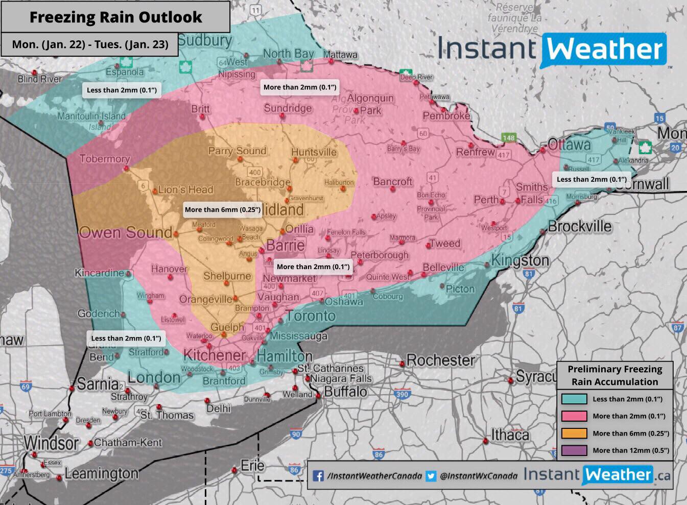
We continue to closely monitor the potential for freezing rain expected to begin Monday and last into Tuesday. Several hours of freezing rain is possible and this would result in horrible driving conditions throughout Monday and the possibility of isolated power outages in the hardest hit areas.
We’re still 2 days away from this event but as of right now, it's starting to become increasingly likely that a large portion of Southern Ontario could be affected by freezing rain, mixed precipitation and heavy rain. Current indications suggest that the heaviest accumulation could occur in areas like the Dundalk Highlands, northern parts of Simcoe County and Muskoka. These area could see ice accumulation in excess of 6mm and perhaps even reaching 12mm in some isolated regions.
Outside of that area, parts of the GTA and east towards Bancroft and Belleville may see ice accumulation exceed 2mm and perhaps reaching 6mm in isolated areas. Further northeast of that zone, including the Ottawa Valley and Kingston/Brockville is expected to get mainly a mix of snow and ice pellets with a few hours of freezing rain possible limiting accumulation to around 1-6mm.
The timing and exact severity of this storm remain uncertain at this point. It looks like some areas may get well above the freezing mark and switch over to rain which will prevent any long-lasting impacts due to the ice accumulation. A cool down and strong winds are expected on Tuesday, so if some regions remain under the freezing mark during the duration of this event we could less isolated power outages.
A few models are pulling the heaviest freezing rain accumulation further into eastern Ontario and showing mainly rain for areas to the west. However, it's questionable at this time if that will happen.
Here’s a good guide from the Red Cross on preparing for winter storms (including ice storms): http://www.redcross.org/get-help/how-to-prepare-for-emergencies/types-of-emergencies/winter-storm#About
We’ll have more details throughout the next few days so be sure to check back for the most up to date information!
- IWO (Brennen P. & Adam S.)
P.S. Just in case you missed it, Facebook has changed how your news feed works! To make sure you see our updates in your news feed, please review this video:
Step 1: Click on "Following" at the top of our page. Step 2: Click "See First" Step 3: Click "Get Notifications" (This step is optional but will certainly help you know if we've posted anything!)