Clipper and Lake Effect Snow to Bring up to 10-20cm of Snow to Southern Ontario
InstantWeather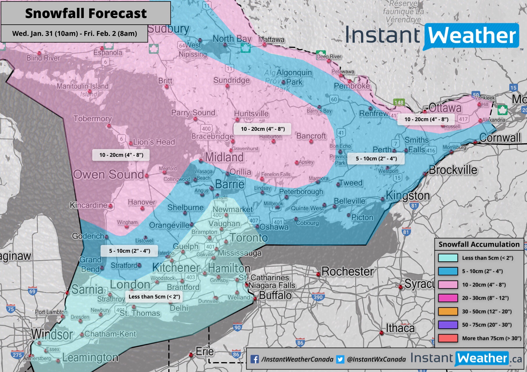
A clipper system is expected to bring widespread snowfall to Southern Ontario beginning early today. Weak lake effect snow will follow after the system moves out tonight around Georgian Bay and Lake Huron continuing into Thursday and Friday.
The light to moderate snowfall has already started in portions of Southwestern and Central Ontario. It looks like the heaviest snow accumulation will occur between this afternoon and evening making for a potentially messy evening commute.
Areas east of Georgian Bay including the Muskoka region and Bancroft will be the hardest hit due to lake enhancement. This area has the potential to see 10-20cm by Friday morning. The GTA and areas around Lake Erie shouldn’t see much accumulation with less than 5cm expected. The system will begin to move out of the region late this evening with the heaviest snowfall ending between 8pm and 12am. Flurries will linger into the morning hours in Central and Eastern Ontario.
Lake effect snow will develop east of Georgian Bay and Lake Huron starting Thursday morning. It will be fairly unorganized and weak so significant accumulation isn’t expected, but an additional 3-7cm on top of the earlier snowfall is possible. Nevertheless, lake effect snow has the potential to quickly reduce visibility out on the roads so be sure to drive according to the conditions.
There are some indications that the lake effect snow may organize into localized snow squalls early Friday and affect the Lake Huron shoreline from Grand Bend to Owen Sound. Some areas may pick up an additional 10-15cm should this happen. We’ll continue to monitor the latest data and post any updates as needed.
- IWO/OBW (Brennen P.)
P.S. We’re watching the potential for another system that will bring snow to Southern Ontario on Sunday into Monday. Right now it looks like accumulation will max out at around 10-15cm, but that could change since we’re still several days out. Check back later for more details.