Significant Snowfall Expected Across Southern Ontario This Weekend; Local Amounts up to 50cm near Lake Huron and Georgian Bay
InstantWeather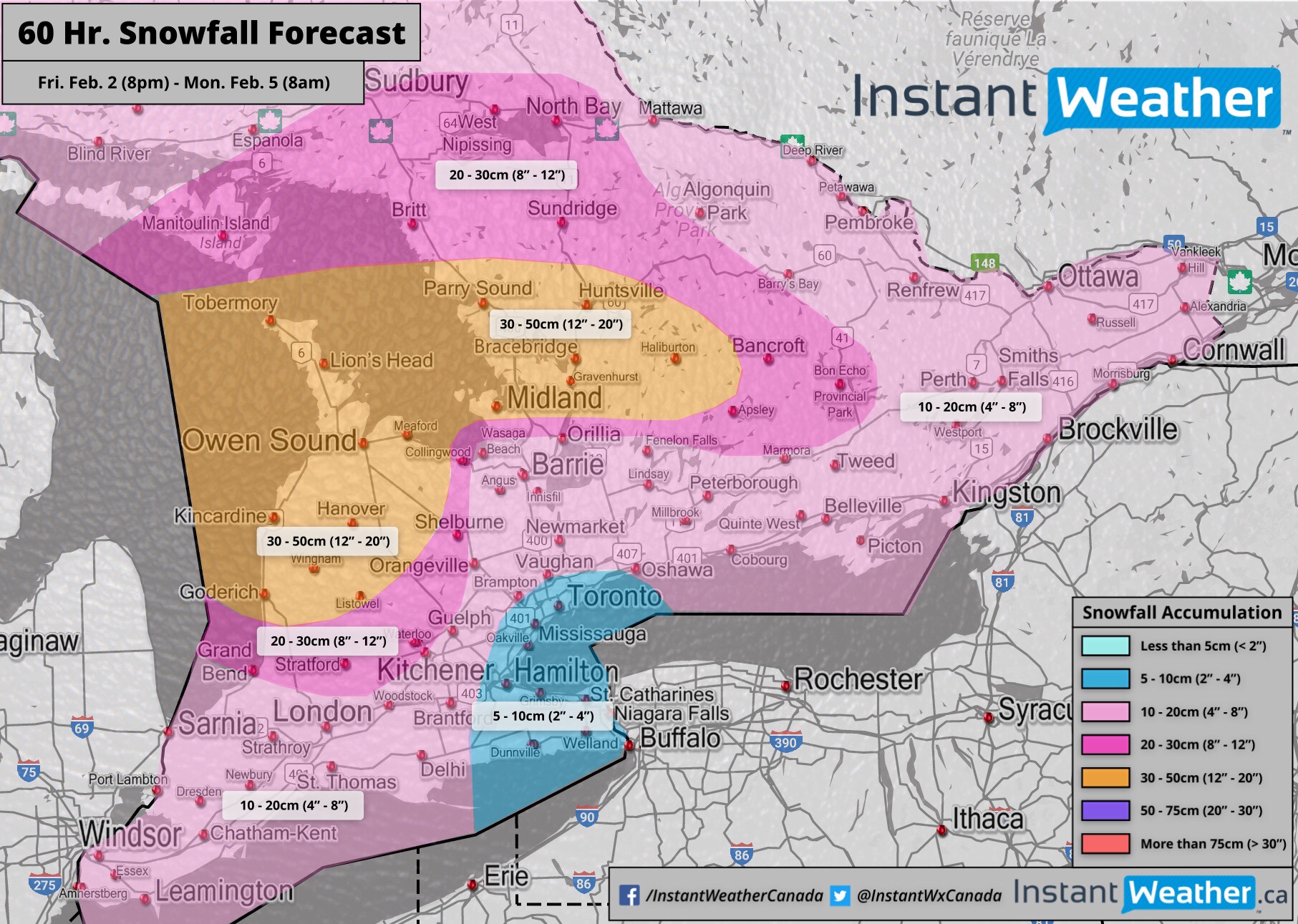
It looks like Mother Nature might have taken Wiarton Willie’s prediction of 6 more weeks of winter a little too seriously.
We’re expecting significant snowfall in parts of Southern Ontario due to a combination of lake effect snow and a system this weekend. Some regions east of Lake Huron and Georgian Bay (Yes that includes Wiarton) may see as much as 30-50cm by Monday morning!
The snow will begin overnight on Friday with lake effect snow and localized squalls stretching from the Bruce Peninsula to between Bracebridge and Orillia. The squalls are expected to intensify during the morning hours with the potential for up to 3-5cm per hour in the strongest squall. It will begin to dissipate around noon with just some flurries lingering around for the afternoon. The hardest hit areas could see anywhere from 10-20cm of accumulation by tomorrow afternoon although it will be very localized.
Starting during the late afternoon or early evening on Saturday we will see a system move in from the west bringing light to moderate snowfall. The heaviest snowfall will be located near Lake Huron and Georgian Bay as we’re expecting lake enhancement to lead to higher accumulation. Snow will continue into Sunday and the system will begin the intensify on Sunday morning resulting in the snow to become heavier across Southern Ontario. It should begin to taper off during the evening or overnight hours as the system moves out of our region.
Generally, most areas will get 10-20cm from this system although the latest data suggest that the GTA and Niagara region could see slightly less near the 7-9cm mark. As mentioned above, areas around Lake Huron and Georgian Bay will see higher accumulation as a result of lake enhancement. This will add around an extra 10cm to the system totals so accumulation will range from 20-30cm in this area.
When you combine the 10-20cm from the lake effect snow with the 20-30cm system snowfall it gives a combined total of 30-50cm for the entire weekend. Blowing snow will also be a concern starting Sunday morning with wind gusts reaching 40-70km/h.
We’ll continue to monitor the latest data and post updates as needed.
- IWO (Brennen P.)