Another Winter Storm to End off the Week with 15-25cm of Snowfall Accumulation in Southwestern Ontario
InstantWeather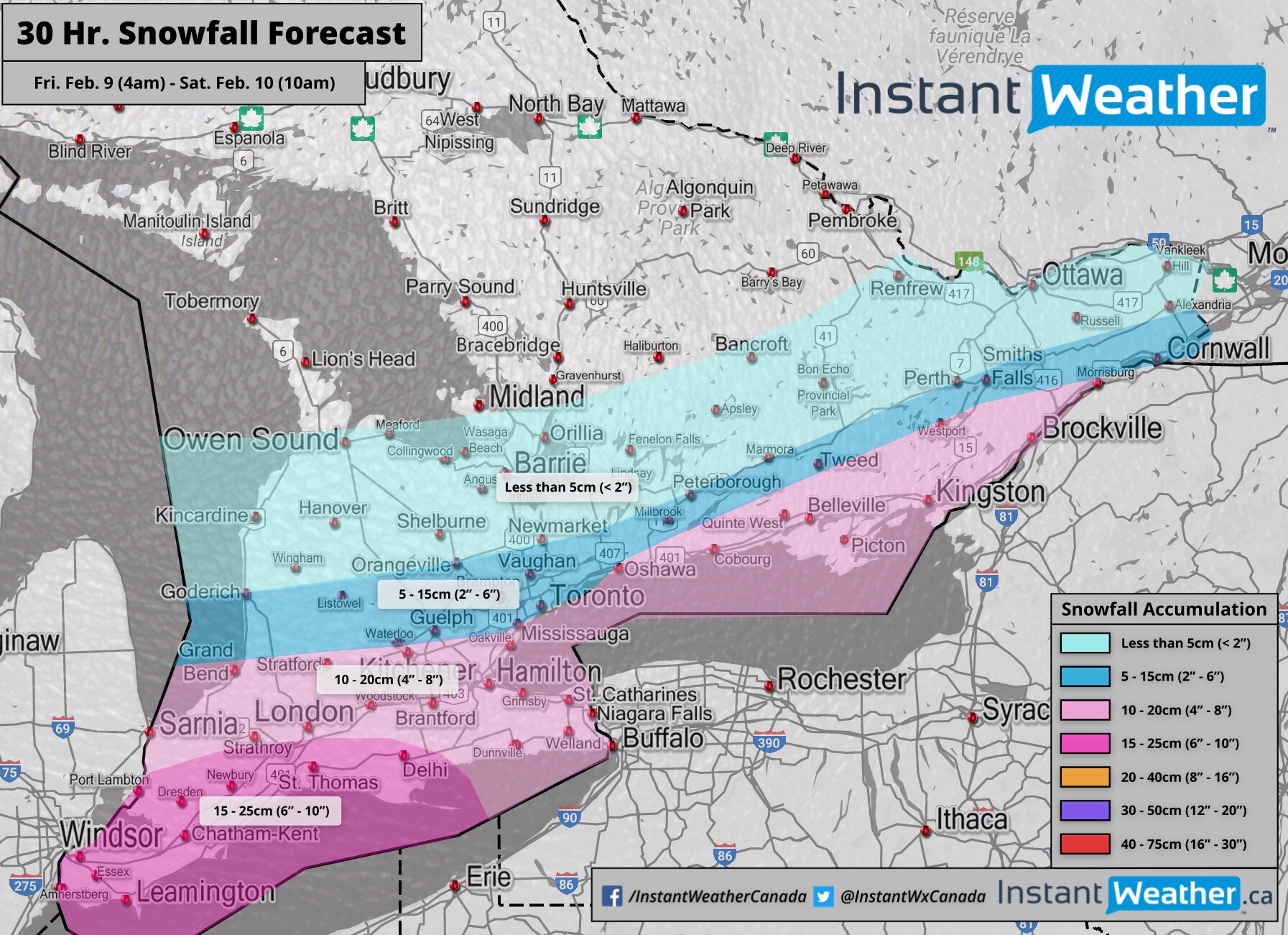
Déjà vu...
Step 1. Winter storm expected to begin as early as 4am Friday in Extreme Southwestern Ontario (Windsor, Essex County, etc)
Step 2. The snow will continue into the evening, where it will calm down for some
Step 3. On Saturday afternoon, it will shift a bit north and bring more snow to parts of the region
Step 4: Then, another winter storm will bring possibly 5-10cm on Sunday
Extreme Southwestern Ontario will feel the brunt of this first storm with 15-25cm of snowfall accumulation possible by Saturday morning. The second punch on Saturday afternoon will bring 5-10cm, and the third round on Sunday could potentially bring another 5-15cm to some areas. Total accumulation by the end of the weekend may exceed 30cm in some locations!
The first system will move into the Windsor, Sarnia and Chatham region early Friday morning and spread eastward, with lower totals towards the Golden Horseshoe, GTA and Eastern Ontario later in the day. The snow will be quite light in the beginning, but quickly pick up throughout the morning with the heaviest snowfall occurring during the afternoon. It will calm down somewhat as we get into the evening hours, though, consistent moderate snowfall will continue into Saturday morning for some areas before tapering off.
The heaviest snowfall should be contained within areas close to the northwestern shoreline of Lake Erie including Windsor, Leamington and St. Thomas. At this point, it looks like widespread accumulation in this region will range from 15-25cm. However, very isolated amounts near 30cm can’t be ruled out in areas like LaSalle, Amherstburg, and perhaps even Windsor.
The gradient between light and heavy accumulation will be tight and drop off quickly the further north you go from Lake Ontario and Lake Erie. Locations south of a line from extending from Grand Bend to Mississauga and up into Morrisburg will see around 5-15cm of accumulation. The central portion of GTA including the city of Toronto should see slightly less than 10cm.
The snow will stop for 4-6 hours on Saturday before the afternoon snow begins. The track of this second punch will be quite similar to the first one, but a bit further north towards areas east of Lake Huron into the northern GTA. There’s some uncertainty about how much snowfall this system will add to the accumulation. The consensus in the models is maxed at around 10cm with most areas getting closer to the 5-7cm mark. We’ll keep you updated on the progression of that third round on Sunday in the next few days!
Wondering what your chances of a snow day are in your area? We’ll have our custom snowday forecast for tomorrow morning across Southern Ontario posted between 8-10pm tonight. Don’t forget to check in with us in the morning for an up-to-date list of bus cancellations and school closures starting at 6am!
- IWO/OBW (Brennen P.)