Southern Alberta Experiences One of the Snowiest February on Record
InstantWeatherFebruary has been one of the harshest winters for Albertans in over 3 years. This past month alone has been the coldest February and the snowiest in 4 years. In particular, the City of Calgary has seen its snowiest winter since September, 2014. That event saw massive amounts of wet snow that caused big problems including snapping tree branches and multiple power outages.
Luckily, the snow accumulations have remained mostly of the dry variety due to the colder temperatures. The City of Calgary’s record for snow in February was around 49 cm in 1896, while to date, well over 42cm has accumulated on the ground.
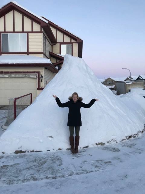
- (Photo Credit: Tristan Bauer) Katie Summers in front of a mountain of snow in the City of Calgary after the first 3 rounds of heavy snow*
On February 3rd, the day after our friend Balzac Billy (Groundhog Day) announced an early spring, an Arctic front barreled through bringing a wave of heavy snow to much of Central and Southern Alberta. Grande Prairie picked up a total of 21 cm of snow, while Calgary got less than 10-15 cm across the city. Visibility was a concerning factor as high winds were reported throughout the area. Wet snow also wreaked havoc on popular roadways throughout the city. The popular route Deerfoot Trail had to be shut down for a number of hours because of the very harsh weather conditions and multiple collisions that had occurred.
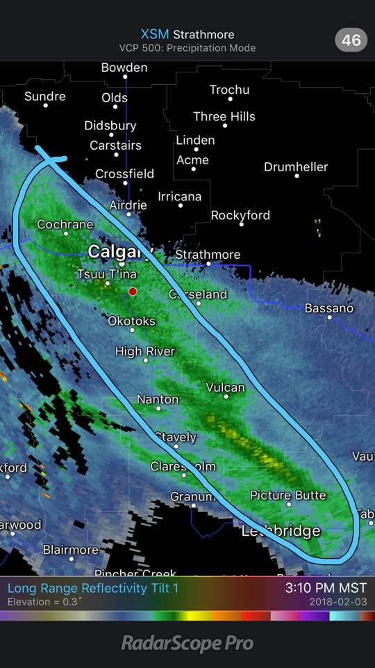
- Radar image via Radarscope of the band of snow in Southern Alberta. The main forcing on the band became frontogenetic with an upslope flow.*
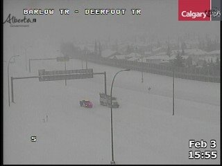
- Webcam picture along Deerfoot Trail when it was closed from Alberta Government and City of Calgary on February 3, 2018.*
On February 4th, Calgary and Southern Alberta experienced a continuation of snowmageddon. An additional 5-15 cm fell across the City of Calgary once again. This time the heaviest snow fell in the Lethbridge and Milk River regions with accumulations of 15-20 cm of snow.
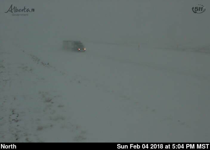
- (Courtesy of Province of Alberta) 511 Alberta Webcam along Highway 4 at Warner AB February 4, 2018.*
On February 8th, the next major storm system plagued Southern Alberta. School bus service and school closures were experienced across Lethbridge, Taber and parts of Calgary. Calgary Transit reported several big delays that morning due to power outages caused by the storm. Many flights out of the Calgary International Airport were canceled. Travel was not recommended on many Alberta highways and a few accidents were reported including incidents along Highway 1 near Standard that brought traffic to a standstill.
Travel was reported much worse in the mountain park areas. Highway 1 closed from Lake Louise, AB all the way to Revelstoke, BC. There were several highway closures due to treacherous conditions on Highway 93 from Castle Mountain Junction to Radium Hot Springs. The Alberta Emergency Alert issued a Winter Storm Alert for Forty Mile County due to whiteout conditions on the highways. Officials indicated road clearing would several days to complete.
Here is a summary of the snow accumulations from Environment Canada on February 8, 2018 Lake Louise 48 cm Frank 30-40 cm Calgary 25-40 cm Water Valley 33 cm Jasper 30 cm Kananaskis 27 cm Sundre 29 cm Banff 25 cm Cochrane 25 cm Medicine Hat 21 cm Brooks 16-20 cm Red Deer 15-25 cm *Rocky Mountain House 15-25 cm
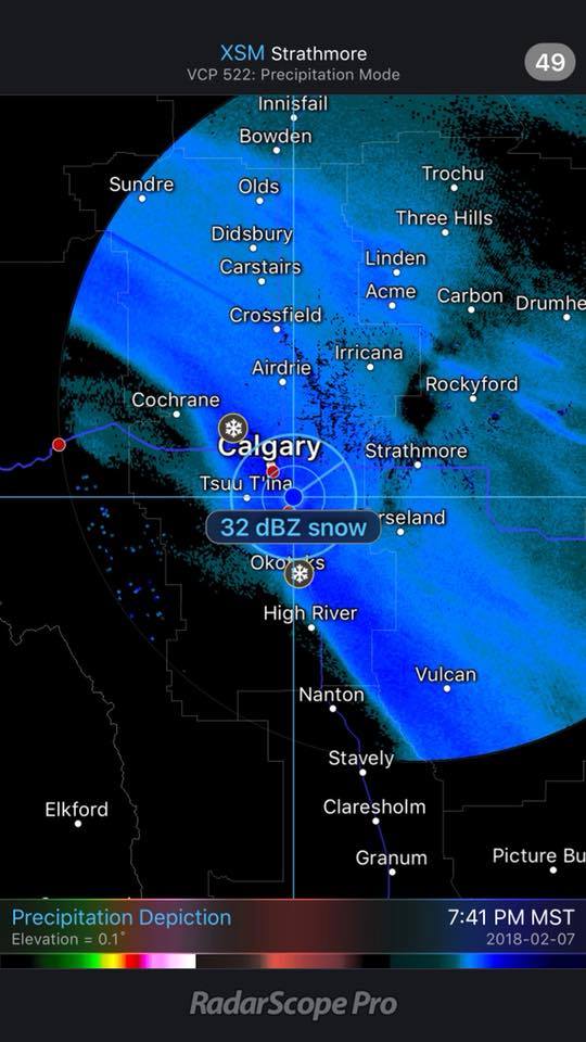
- Radar Image from Radarscope evening of February 7, 2018 beginning of the winter storm at Calgary with snowfall rates 5-8 cm an hour!! (Courtesy of RadarScope)*
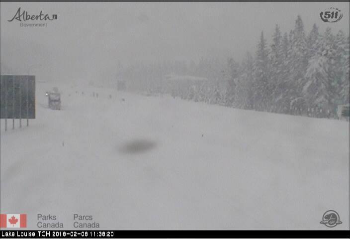
- Highway 1 at Lake Louise AB shut down February 8, 2018 webcam via 511 Alberta and Parks Canada. (Courtesy of Province of Alberta)*
After the storm passed it became brutally cold with temperatures dropping to -40C with windchill values near -50C in select locations. The big story a few weeks ago was the blowing snow and a much-needed chinook in the Rockies boosting temps to +10C in Calgary, which melted some of that snowpack. It was also mild enough that rain showers took place in the Edmonton area. On February 13th, strong winds gusts exceeded 110km/h causing problems with rapid melting/freezing, producing slick conditions thereby causing jackknifing problems on Southern Alberta highways.
Crews struggled to finish snow clearing on the roads in the Cypress Hills due to the intense drifting. Once again, the Alberta Emergency Alert system issued a Winter Storm Alert and travel was not recommended. Highway 3 was closed too from Pincher Creek to Lundbreck due to the blowing snow and reduced visibility.
On February 14th, a brutal Arctic Front barreled through the province causing some big problems with blowing snow and near white-out conditions. These conditions we’re a leading factor in the vehicle pileup along the QE2 at Lacombe. The system brought more snow to Southwestern Alberta, but it was more of a wind maker with gusts up to 80 km/h in many areas. Highway 1 was closed from Strathmore to Brooks for several hours.
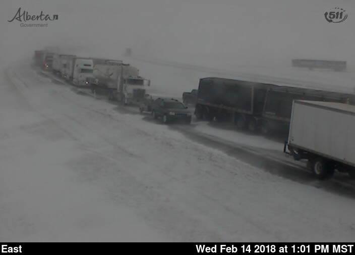
- 511 Alberta Webcam pic along Highway 1 at Bassano at the time the highway was closed and trucks were waiting. (Courtesy of Province of Alberta)*
8 9 10
- Pictures above showing a stop sign getting buried by a drifting and fresh snow at Cowley Alberta. (Photo Credit: T. Lucas/ Pincher Creek Voice)*
-(IWA Brandon H.)
References:
http://climate.weather.gc.ca/climate_data/daily_data_e.html?StationID=50430
https://weather.gc.ca/warnings/weathersummaries_e.html#AB
http://511.alberta.ca/map.html#x=-12764223&y=6441222&z=1&lb=1&rb=1&l=36