Major Ice Storm Becoming More Likely for Parts of Southern Ontario Including the GTA on Sunday; Strong Wind Gusts Could Lead to Widespread Power Outages
InstantWeather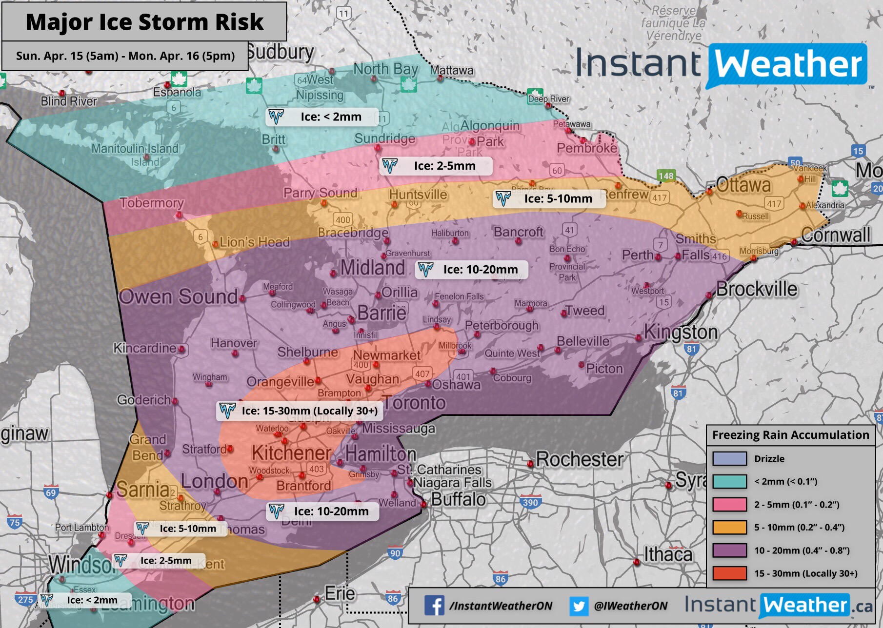
Concern is growing over what could be a major and as per Environment Canada, “historic” ice storm that will affect parts of Southern Ontario on Sunday. Damaging wind gusts possibly reaching 100km/h in some areas will further enhance the impacts that the significant icing will have on power lines and trees.
With the first round of precipitation tapering off this evening, we’ll enter a dry slot overnight. Although, don’t be caught off guard because the calmness will quickly end early Sunday morning as precipitation moves into our region. It will begin as ice pellets and slowly transition over to freezing rain. The freezing rain will become quite heavy into the late morning and afternoon hours. There are indications that the cold air might stay locked in longer than expected so the freezing rain may not end until into the evening.
For Central and Eastern Ontario, a longer period of ice pellets is expected before the switch over to freezing rain. The freezing rain will then start early in the afternoon and could last well into the overnight hours or even Monday morning. At this point, school bus cancellations look quite likely for Monday within those regions, but this depends on the timing and how this storm plays out.
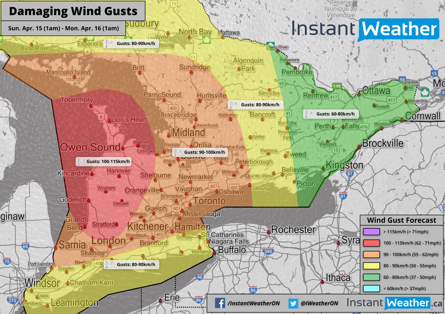
To make matters worse, the wind will begin to pick up starting Sunday afternoon. Some areas around Lake Huron and into the Niagara escapement may see damaging wind gusts reaching as high as 100km/h at times. Elsewhere, a wide swath of our region has the potential to see maximum wind gusts between 70-100km/h. This will coincide with the heavy freezing rain so substantial impacts on the power grid is possible. Widespread and long-lasting power outages that could last for days are a possibility in the hardest hit areas.
We believe the hardest hit areas could include much of the GTA away from the lakeshore and extending into the Guelph, Kitchener/Waterloo and Orangeville regions. Those closest to the lakeshore (including Toronto and Hamilton) will still see significant icing, but expected to switch over to rain a few hours earlier than surrounding areas. Ice accretion in these regions will range from 15mm to 25mm with the possibility of localized regions picking up 30mm+. A fairly wide swath of Southern Ontario will see 10-20mm of ice accretion including much of Southwestern, Central and Eastern Ontario. Refer to our forecast map for specific details on potential accumulation for your area.
It should be mentioned there’s the slight possibility that we may see a lot more ice pellets than is currently expected. If this happens, it could dramatically reduce the actual ice accretion that occurs. Current short range model data has indicated that this is unlikely to occur, but don’t be surprised if this event underperforms the forecast if we see more pellets. We should know for certain what will happen early tomorrow morning so stay with us for the latest information.
- IWO (Brennen P.)