Tomorrow: Winnipeg, Brandon, Portage la Prairie, Winkler, Dauphin & The Pas Included in Environment Canada's Forecast Map for 90-100km/h Wind Gusts & 2-3cm Hail (Tue, June 26, 2018)
InstantWeather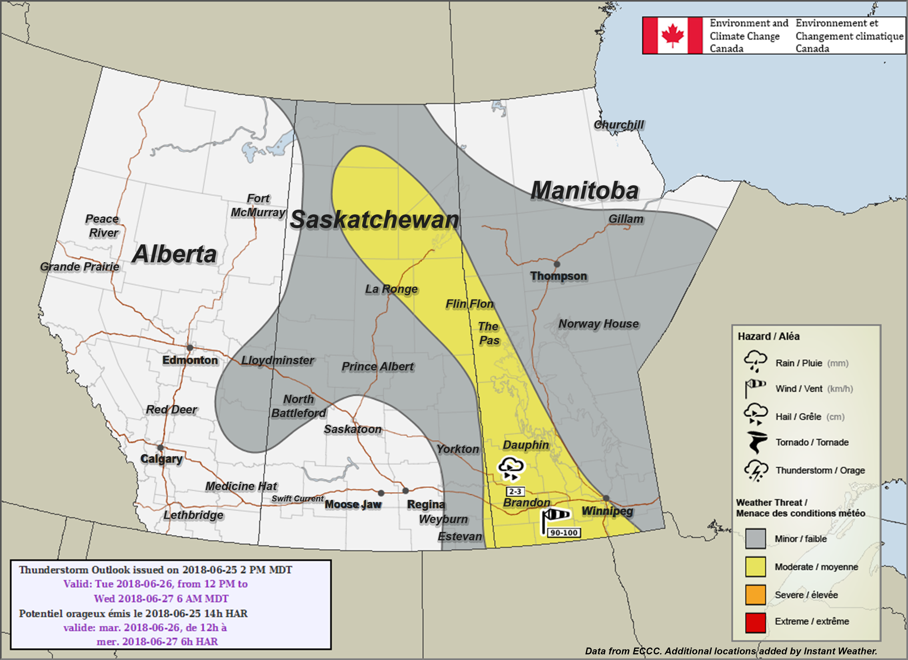
(Exhaustive list of potentially affected locations listed below)
Environment Canada wrote:
"Manitoba
Area(s): Everywhere except the extreme north
Timing: Tuesday afternoon and evening into the overnight hours
Threats: 2-3 cm hail, wind gusts 90-100 km/h in the west. Non-severe thunderstorms elsewhere.
Thunderstorms are expected to develop in western Manitoba Tuesday afternoon as a cold front moves in from Saskatchewan. Some of these storms may be severe with large hail and damaging winds. Thunderstorms are also expected to develop along a frontal trough and warm front in central and northern Manitoba, however these storms are not expected to be severe."
PLEASE READ: For those wondering, these "prototype" maps are not yet available on EC's website. However, they will become operational soon and shared directly on their site. These forecasts and maps are issued by the same Environment Canada Meteorologists that issues all Watches and Warnings for the prairies. They're also temporarily hosted by the University of Manitoba here:
https://umanitoba.ca/faculties/environment/envirogeog/weather/conv_otlk/
Environment Canada's disclaimer says:
"Disclaimer: These products are part of an experimental initiative at Environment and Climate Change Canada (ECCC). These are not official ECCC products and therefore may not be available on a daily basis. Please continue to monitor weather forecasts as well as watches and warnings via http://www.weather.gc.ca/. Please address any questions, concerns and/or feedback regarding these products to the Decision Support Meteorologists at the Prairie and Arctic Storm Prediction Centre, available by email at ec.soutienmeteoouest-weathersupportwest.ec@canada.ca."
Exhaustive list of potentially affected locations:
- Alexander
- Algar
- Alonsa
- Alpine
- Altamont
- Altbergthal
- Altona
- Amaranth
- Ameer
- Angusville
- Arbakka
- Arden
- Argue
- Argyle
- Arizona
- Armstrongs Point
- Arnaud
- Arrow River
- Asham Point
- Ashville
- Assiniboia
- Assiniview Park
- Athapap
- Atik
- Aubigny
- Austin
- Aweme
- Babcock
- Bacon Ridge
- Baden
- Bagot
- Bakers Narrows
- Baldur
- Balmy Beach
- Baragar
- Barkfield
- Barnsley
- Barrows
- Basswood
- Bayend
- Beaudry
- Beaumont
- Beaver
- Bede
- Belleview
- Bellsite
- Belmont
- Bénard
- Benito
- Benyks Point
- Beresford
- Bernice
- Bethany
- Beulah
- Bield
- Big Island Lake
- Big Woody
- Binney
- Binscarth
- Birch River
- Birchview
- Birchwood
- Birdinia
- Birdtail
- Birdtail Sioux
- Birnie
- Birtle
- Bloom
- Bluff Creek
- Blumenfeld
- Blumengart
- Boggy Creek
- Boissevain
- Bowsman
- Bradwardine
- Brandon
- Brandon Hills
- Briggs Spur
- Bright Oaks
- Bristol
- Brookdale
- Brooklands
- Broomhill
- Brown
- Bruce Park
- Brumlie
- Brunkild
- Bruxelles
- Bunclody
- Butler
- Cabot
- Cadurcis
- Caliento
- Calrin
- Cameron
- Camperville
- Carberry
- Carberry Junction
- Cardale
- Cardinal
- Carey
- Carlowrie
- Carman
- Carnegie
- Carroll
- Cartwright
- Caye
- Cayer
- Centennial
- Channing
- Charleswood
- Chater
- Cherry Point
- Chillon
- Chimo Resort
- Chortitz
- Chumah
- City Centre
- Clanwilliam
- Clarkleigh
- Clearwater
- Clearwater Lake
- Comeau
- Cordova
- Cottonwoods
- Coulter
- Cowan
- Cracknell
- Craigsford
- Cranberry Portage
- Crandall
- Crane River
- Cranmer
- Crawford Park
- Crescent Cove Beach
- Crescent Park
- Crescentwood
- Crestview
- Crocus
- Croll
- Cromer
- Crystal City
- Culross
- Curtis
- Cypress River
- Dacotah
- Dakota Crossing
- Dakota Plains
- Dakota Tipi
- Dalny
- Dand
- Darlingford
- Dauphin
- Dauphin Beach
- Dawson Bay
- Decker
- Deepdale
- Deer
- Deer Lodge
- Deerwood
- Deleau
- Deloraine
- Delta Beach
- Denbow
- Ditch Lake
- Dog Creek
- Dolly Bay
- Domain
- Dominion City
- Douglas
- Drifting River
- Dropmore
- Dry River
- Duck Bay
- Duck River
- Dufrost
- Dunrea
- Durban
- Dutton
- East Bay
- East End
- Ebb and Flow
- Ebor
- Eclipse
- Eddystone
- Eden
- Edenburg
- Edillen
- Edrans
- Edwin
- Elgin
- Elie
- Elk Ranch
- Elkhorn
- Elm Creek
- Elm Park
- Elmhurst
- Elphinstone
- Elva
- Emblem
- Endcliffe
- Erickson
- Ethelbert
- Ewart
- Exira
- Fairfax
- Fairfield Park
- Fairview
- Fallison
- Fannystelle
- Faulkner
- Ferndale
- Findlay
- Firdale
- Fishing River
- Five Corners
- Flee Island
- Flin Flon
- Floors
- Fork River
- Forrest
- Fort Garry
- Fort la Reine
- Fort Richmond
- Fort Rouge
- Fort Whyte
- Fortier
- Foxwarren
- Franklin
- Fredensthal
- Freedale
- Freshford
- Friedensfeld
- Friedensfeld West
- Friedensruh
- Fulton
- Gambler
- Garden Grove
- Gardenton
- Garland
- Gilbert Plains
- Gladstone
- Glen Elmo
- Glenboro
- Glencairn
- Glencross
- Glenella
- Glenforsa
- Glenlea
- Glenlochar
- Glenora
- Gnadenfeld
- Gnadenthal
- Good Harbour
- Goodlands
- Goulbourne
- Grace Lake
- Graham
- Grande Pointe
- Grande-Clairière
- Grandview
- Grant Park
- Grass River
- Graysville
- Green Ridge
- Greenacres
- Greenfarm
- Greenway
- Gregg
- Gregorys Mill
- Grifton
- Griswold
- Grosse Isle
- Grund
- Grunthal
- Hacienda
- Halbstadt
- Halicz
- Hallboro
- Hamburg
- Hamilton Heights
- Hamiota
- Harcus
- Harding
- Hargrave
- Harlington
- Harmsworth
- Harrowby
- Harte
- Hartney
- Hartney Junction
- Haskett
- Hayfield
- Hayland
- Haywood
- Headingley
- Heaslip
- Helston
- Heritage Park
- High Bluff
- Highland Park
- Hilltop
- Hilton
- Hochfeld
- Hochstadt
- Holland
- Holmfield
- Homewood
- Hoop and Holler Bend
- Horndean
- Horod
- Howden
- Hughes
- Hummerston
- Ile des Chênes
- Indian Birch
- Indian Springs
- Ingelow
- Inglis
- Ipswich
- Isabella
- Johnson
- Justice
- Kaleida
- Kane
- Katrime
- Keeseekoowenin
- Keld
- Kelloe
- Kelwood
- Kemnay
- Kenton
- Kenville
- Kergwenan
- Kerrs Lake
- Keyes
- Kilman
- Kingsley
- Kingston Crescent
- Kinosota
- Kirkcaldy Heights
- Kirkella
- Kirkfield Park
- Kleefeld
- Koko Platz
- Kola
- Kronsgart
- Kronsthal
- Kulish
- La Barrière
- La Rivière
- La Rochelle
- La Salle
- Ladysmith
- Laguna Beach
- Lake Audy
- Lake Francis
- Lake Manitoba First Nation
- Lakeland
- Lakewood
- Landseer
- Langruth
- Langs Crossing
- Larkhill
- Lauder
- Laurentia Beach
- Laurier
- Lavenham
- Lavinia
- Layland
- Learys
- Leifur
- Leighton
- Lena
- Lennard
- Lenore
- Lenswood
- Letellier
- Levine
- Lido Plage
- Lidstone
- Lily Bay
- Lilyfield
- Linden Lanes
- Linden Woods
- Linklater
- Little Ridge
- Lobbville
- Lone Spruce
- Lonely Lake
- Long Plain
- Longburn
- Lord Selkirk
- Lowe Farm
- Lundar
- Lundar Beach
- Lyleton
- Lyonshall
- Macdonald
- MacGregor
- Mafeking
- Magnet
- Makaroff
- Makinak
- Mallard
- Manhattan Beach
- Manitou
- Manson
- Maples
- Marco
- Margaret
- Mariapolis
- Marquette
- Maskawata
- Mather
- Maybank
- Mayfeld
- McAuley
- McConnell
- McCreary
- McTavish
- Meadow Lea
- Meadow Portage
- Meadowlands
- Meadowood
- Meadows
- Mears
- Medora
- Melbourne
- Melita
- Mellenville
- Mentmore
- Menzie
- Merridale
- Methven
- Metikewap
- Miami
- Million
- Millwater
- Millwood
- Miniota
- Minitonas
- Mink Creek
- Minnedosa
- Minnedosa Beach
- Minnewakan
- Minto
- Mitchell
- Moline
- Moore Dale
- Moore Park
- Moose Bay
- Moostissoostikwan
- Morden
- Morris
- Mountain Road
- Mountainside
- Muir
- Munroe
- Murray Park
- Myrtle
- Napinka
- National Mills
- Neelin
- Neepawa
- Nesbitt
- Neubergthal
- Neuenburg
- New Bothwell
- New Rosa
- Newdale
- Newton
- Ninette
- Ninga
- Niverville
- Noble Lake
- Norberry
- Norgate
- Norman
- Normand Park
- North River Heights
- Norwood West
- Notre-Dame-de-Lourdes
- Novra
- Oak Bluff
- Oak Brae
- Oak Lake
- Oak Lake Beach
- Oak Lake Reserve
- Oak Point
- Oak River
- Oakburn
- Oakland
- Oakner
- Oako Beach
- Oakview
- Oakville
- Oberon
- Ochre Beach
- Ochre River
- Ogilvie
- Old Altona
- Old Tuxedo
- Olha
- Onanole
- Osborne
- Osborne Village
- Osterwick
- Oswald
- Otter Lake
- Otterburne
- Overflowing River
- Overstoneville
- Overton
- Ozerna
- Pansy
- Parc La Salle
- Parkdale Heights
- Parks Corner
- Paulson
- Payuk Lake
- Pebble Beach
- Pelican Point Beach
- Pelican Rapids
- Pendennis
- Peony Farm
- Petlura
- Petrel
- Pettapiece
- Pierson
- Pigeon Lake
- Pilot Mound
- Pine Bluff
- Pine Creek
- Pine Creek Station
- Pine River
- Pipestone
- Pleasant Point
- Pleasant Valley
- Plum Coulee
- Plumas
- Polonia
- Pomeroy
- Pope
- Poplar Point
- Portage la Prairie
- Portia
- Powell
- Pratt
- Pretty Valley
- Prospector
- Pulberry
- Pulp River
- Purves
- Quadra
- Rackham
- Ralls Island
- Randolph
- Rapid City
- Rathwell
- Reaburn
- Red Deer Lake
- Reeder
- Reedy Creek
- Reeve
- Regent
- Reinfeld
- Reinland
- Renwer
- Reston
- Reykjavik
- Rhodes
- Richmond Lakes
- Richmond Park
- Richmond West
- Ridgeville
- Riding Mountain
- Riel
- Ritchot
- River Heights
- River Park South
- River West Park
- Riverdale
- Riverheights
- Rivers
- Riverside
- Riverview
- Roblin
- Roblin Park
- Rock Ridge
- Rocky Lake East
- Rocky Lake North
- Rogers
- Roland
- Rolling River
- Root Lake
- Rorketon
- Rosa
- Roseau River
- Roseau River Reserve
- Rosebank
- Roseisle
- Roseland
- Rosenfeld
- Rosengard
- Rosengart
- Rosenort
- Rosetown
- Roslyn
- Rossburn
- Rossendale
- Rosser
- Rounthwaite
- Routledge
- Rufford
- Russell
- Ruthenia
- Salt Point
- San Clara
- Sandy Bay
- Sandy Lake
- Sanford
- Sargent Park
- Sarto
- Scandinavia
- Scarth
- Schanzenfeld
- Schist Lake
- Schoenwiese
- Sclater
- Scotch Bay
- Seech
- Senkiw
- Sewell
- Shell Valley
- Shellmouth
- Shergrove
- Shevlin
- Shilo
- Shoal Lake
- Shoal River
- Shortdale
- Sidney
- Sifton
- Sifton Junction
- Siglunes
- Silberfeld
- Silver Bay
- Silver Heights
- Silver Plains
- Silver Ridge
- Silverton
- Silverwood
- Sinclair
- Sioux Valley
- Sirko
- Skelding
- Skownan
- Smith Hill
- Smiths
- Snowflake
- Solsgirth
- Somerset
- Somme
- Sommerfeld
- Souris
- South Headingley
- South River Heights
- South St. Vital
- South Tuxedo
- Southboine
- Southglen
- Southport
- Southwood
- Spence Lake
- Sperling
- Springhill
- Springstein
- Spruce Bluff
- Spruce Creek
- Sprucewoods
- St-Lazare
- St-Pierre-Jolys
- St. Adolphe
- St. Alphonse
- St. Ambroise
- St. Charles
- St. Claude
- St. Eustache
- St. François Xavier
- St. Germain
- St. Germain South
- St. James
- St. Jean Baptiste
- St. Joseph
- St. Laurent
- St. Leon
- St. Lupicin
- St. Malo
- St. Marks
- St. Norbert
- St. Pierre Sud
- St. Vital
- Starbuck
- Ste. Agathe
- Ste. Amélie
- Ste. Elizabeth
- Ste. Rose du Lac
- Steels Ferry
- Steep Rock
- Stephenfield
- Stockport
- Stockton
- Strathclair
- Strathcona Park
- Stuartburn
- Sturgeon Creek
- Sundown
- Sunnyside Beach
- Sunville
- Swan Lake
- Swan Lake Reserve
- Swan River
- Tenby
- The Corners
- The Narrows
- The Pas
- The Pas Airport
- Thornhill
- Thunder Hill
- Tilston
- Timberton
- Tin Town
- Tolstoi
- Tourond
- Toutes Aides
- Treesbank
- Treesbank Ferry
- Treherne
- Tremaine
- Trembowla
- Trentham
- Trinity Park
- Tummel
- Turnberry
- Tuxedo
- Twin Lakes Beach
- Two Creeks
- Tyndall Park
- Ukraina
- Umpherville
- Underhill
- Union Point
- Uno
- Valley River
- Valley River Reserve
- Valleyview
- Varsity View
- Venlaw
- Vermette
- Victor
- Victoria Crescent
- Vimy Ridge
- Virden
- Vista
- Vita
- Vogar
- Volga
- Wakopa
- Waldersee
- Walkerburn
- Wanless
- Wapah
- Warren
- Wasagaming
- Waskada
- Waterhen
- Waterhen Reserve
- Waverley
- Waverley Heights
- Wawanesa
- Waywayseecappo
- Weiden
- Wellwood
- West End
- Westbourne
- Westdale
- Westgate
- Weston
- Westray
- Westview
- Westwin
- Westwood
- Wheatland
- White Plains
- Whitewater
- Whithorn
- Whitmore
- Whyte Ridge
- Wildwood
- Willen
- Wingham
- Winkler
- Winnipeg
- Winnipegosis
- Wisla
- Wolseley
- Wood Bay
- Woodhaven
- Woodlands
- Woodmore
- Woodnorth
- Woods Creek
- Woodside
- Worby
- Worthington
- Young Point
- Zelana
- Zelena
- Zhoda
- Zoria
More details ASAP!
- Adam S.