EXTREME RISK for Edmonton from Environment Canada for up to Tennis Ball Hail, 90-110km/h Wind Gusts & the Risk for a Tornado. (Fri, July 20th, 2018)
InstantWeather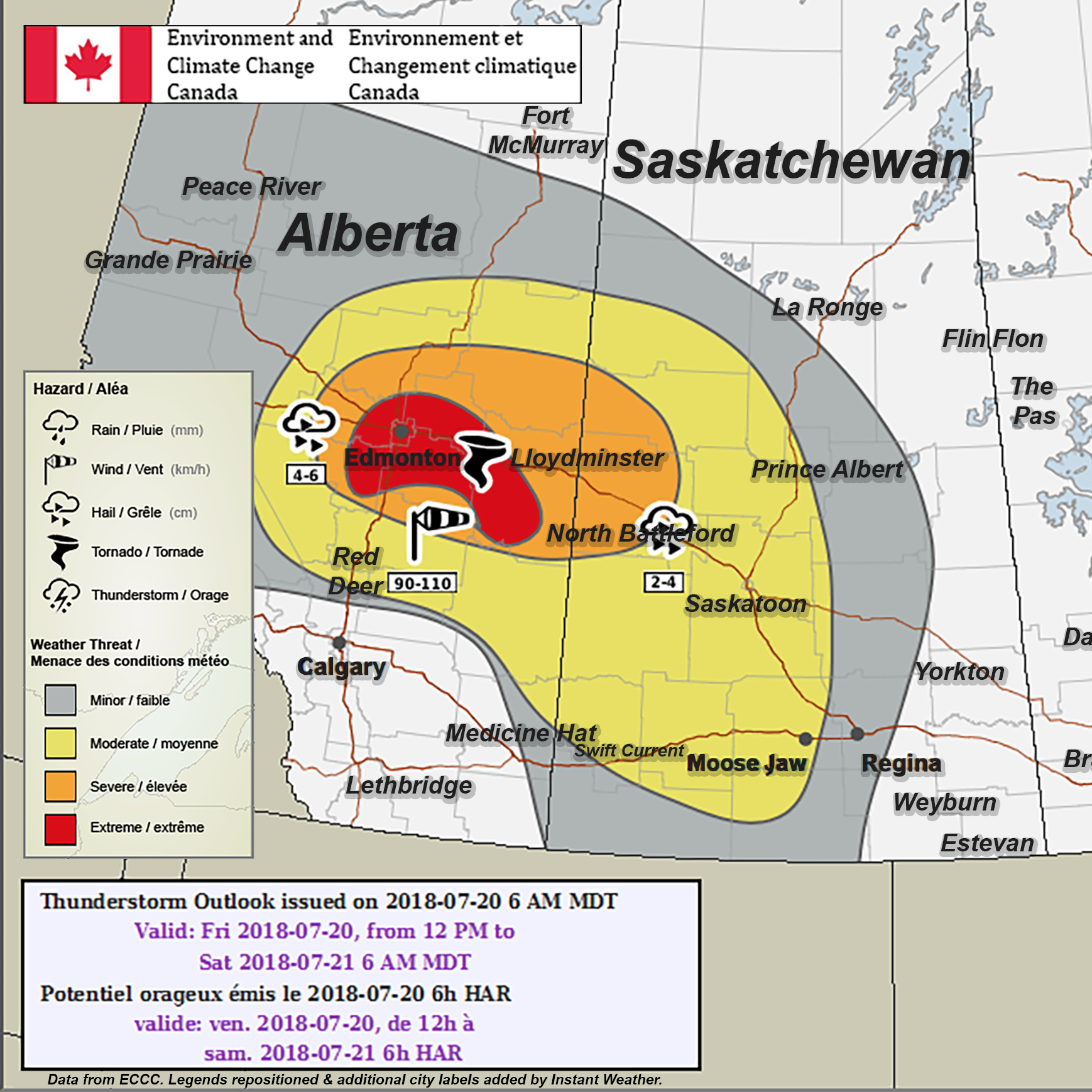
PLEASE READ DISCLAIMER BELOW
We've also included the "Technical Discussion" below the typical summary as it mentions "There is the potential for the right conditions to align near and to the east of Edmonton for a tornado to form...".
Here's what Environment Canada wrote:
"Alberta
Area(s): Central Alberta
Timing: Friday afternoon to overnight
Threats: 4-6 cm hail and risk of a tornado
A low pressure system will form just to the south of Edmonton, which will be the focus of thunderstorms for today. Scattered severe thunderstorms are expected to develop early this afternoon along the northern foothills. These thunderstorms will move northeast throughout the afternoon and evening before weakening overnight. Large hail, up to tennis ball size, will be the main threat with these severe thunderstorms with a risk of a tornado near and to the east of the Capital Region in the afternoon and evening hours.
Technical Discussion:
A low pressure system will form south of Edmonton today with an associated cold front extending southward along the northern foothills and warm front through east-central Alberta and into Saskatchewan. Severe thunderstorms will trigger along the cold front early in the afternoon. They will likely be isolated in nature at first, before becoming a severe line of thunderstorms. The warm front will track through the area in the morning followed by a trough in the afternoon. Severe thunderstorms are expected to trigger along the trough in the afternoon. There is the potential for the right conditions to align near and to the east of Edmonton for a tornado to form, with the potential extending into west-central Saskatchewan, albeit, less likely than the risk in Alberta. MLCAPE values are between 1500 to 2200 J/kg with 0-6 km shear values around 30 kt with values up to 40 kt in and around the Capital region in Alberta. RDPS prog tephis are indicating idealized veering hodographs, conducive to tornado development, however, tornado formation in this area will be highly dependent on a few factors: There is the potential that the low level shear will be too much for the marginal CAPE in some areas, essentially shearing the storms apart. As well, on the Saskatchewan side, LCLs are progged to be around 1500 - 2000 m, which is a little high for tornado development, whereas, on the Alberta side, LCLs are progged to be 1000 m, which is more favourable for the formation of tornadoes. In addition, models are indicating the formation of a dryline that will bulge out into the southwestern corner of the Lloydminster region which may also be an area to watch for a tornado to develop in the later afternoon hours."
PLEASE READ: For those wondering, these "prototype" maps are not yet available on EC's website. However, they will become operational soon and shared directly on their site. These forecasts and maps are issued by the same Environment Canada Meteorologists that issues all Watches and Warnings for the prairies. They're also temporarily hosted by the University of Manitoba here:
https://umanitoba.ca/faculties/environment/envirogeog/weather/conv_otlk/
Environment Canada's disclaimer says:
"Disclaimer: These products are part of an experimental initiative at Environment and Climate Change Canada (ECCC). These are not official ECCC products and therefore may not be available on a daily basis. Please continue to monitor weather forecasts as well as watches and warnings via http://www.weather.gc.ca/. Please address any questions, concerns and/or feedback regarding these products to the Decision Support Meteorologists at the Prairie and Arctic Storm Prediction Centre, available by email at ec.soutienmeteoouest-weathersupportwest.ec@canada.ca."
More details ASAP!