FORECAST UPDATE: Isolated Strong Thunderstorm Risk through Georgian Bay, Lake Simcoe and East. (Mon, Aug 27th, 2018)
InstantWeather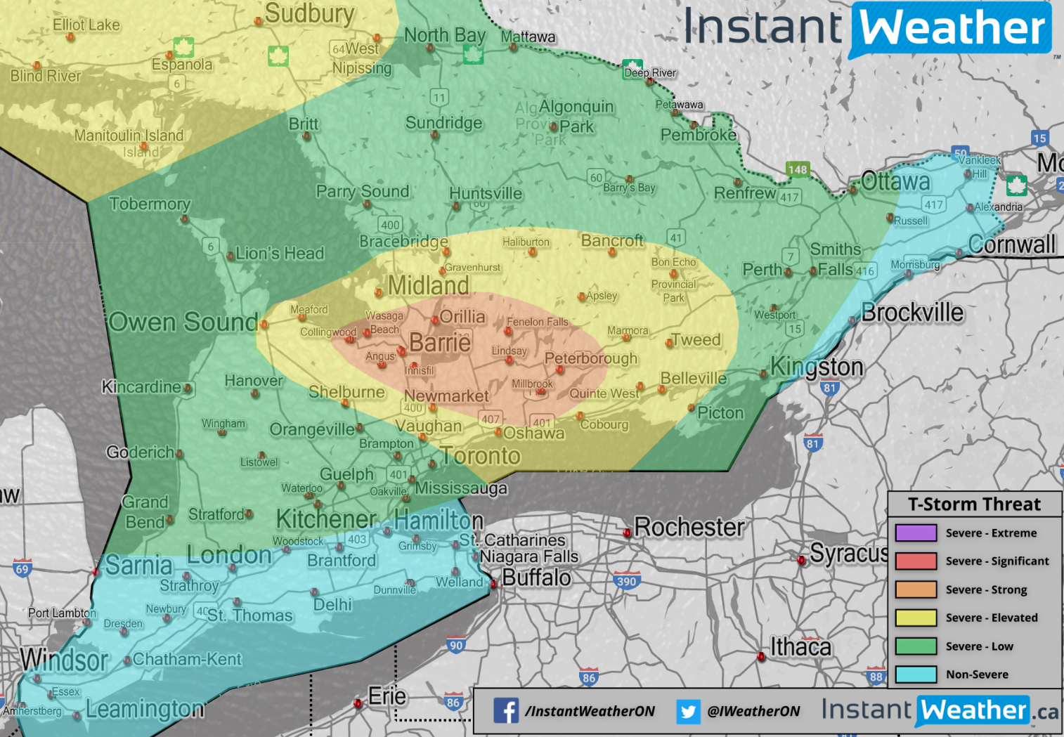
IMPORTANT: This is a risk map. This doesn't mean you're going to see thunderstorms. This simply means, IF you see thunderstorms, what the potential risks could be. Most folks in the southwestern Ontario, GTA, Niagara should remain completely dry. Storms should only develop south of Georgian Bay and east towards Lake Simcoe & into eastern and Northeastern Ontario. Little pop-up storms are possible elsewhere but questionable.
As we originally mentioned, we've been closely watching this system for over a week and the main issue has been the lack of storm development. However, we are still seeing models consistently suggesting that there will be storm development in this highlighted yellow/orange area this afternoon and/or evening. Potentially spawning off of Georgian Bay by 3/4pm and tracking southeast towards Barrie and areas southeast of Lake Simcoe by 5/6/7pm.
These storms have the potential to become dangerous with frequent lightning, hail, damaging wind gusts, isolated flooding and if everything comes together, isolated tornadoes are a possibility. Regardless of what happens this afternoon/evening, we'll be watching very closely and we'll let you know if and when something serious develops.
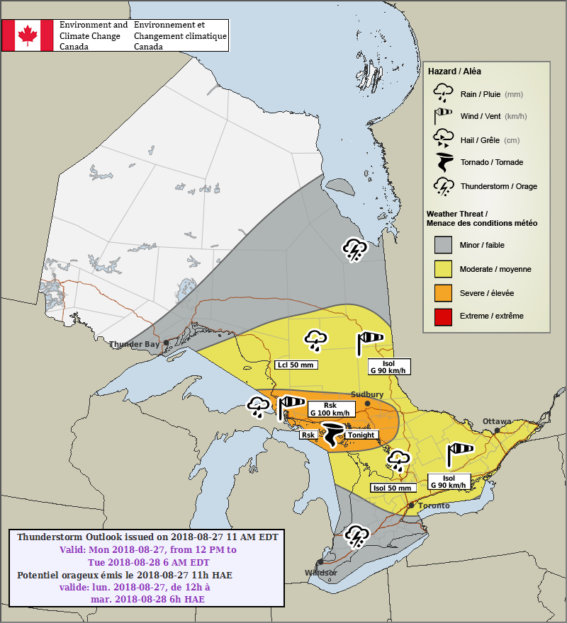
We're also noticing a potential severe weather risk overnight from Sault Ste. Marie into possibly the Sudbury and Manitoulin regions. Maybe even the top side of Muskoka and there's a possibility for frequent lightning, damaging wind gusts, flooding and hail with that. Environment Canada has mentioned a possible nocturnal tornado risk for these northern areas in their risk map. We have our doubts but it's not entirely out of the question. Here's their map below:
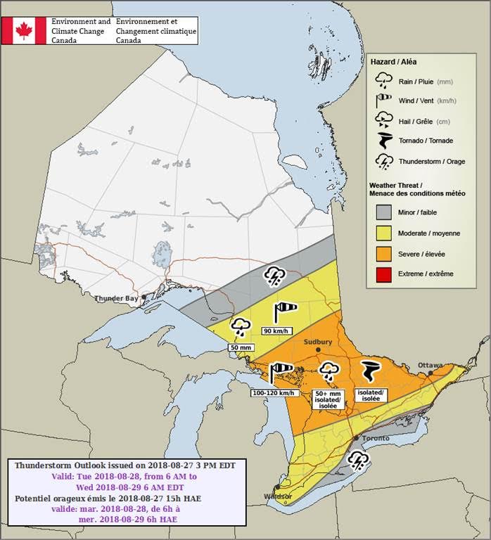
Environment Canada has also mentioned a tornado risk for tomorrow in our region in their Day 2 map below. This isn't out of the question either but the storms will be developing late and into the overnight so the tornado risk is somewhat questionable as overnight storms typically have more difficulty producing tornadoes due to a term known as 'convective inhibition' or 'CIN'. Nevertheless, we'll be watching closely for that risk too and we'll be posting our own forecast map about those potential risks ASAP. Here's EC's Day 2 map:
And as we mentioned yesterday, this may be a good time to subscribe to our instant Text Message Alerts, even just for one month @ $3.39/m as they are the fastest and most reliable severe weather alerts in Canada and don't require internet access which is critical during significant severe weather events. They also work with any cell phone that can receive text messages.
To subscribe, please follow the steps below:
-
Login with Facebook (fastest and easiest login method)
-
Read and agree to our Terms of Use
-
Choose a monthly ($3.39) or yearly ($40.68) subscription option
-
Type in your cell phone number and 1 or 2 addresses (use exact address or postal code for best accuracy)
-
Hit save, and then "Ok" when it asks you to setup Paypal
-
Login to your Paypal account (or create a new one)
- Confirm the billing agreement and that's it!
If you need any further assistance, please email me back at help@InstantWeather.ca to ensure you receive a ticket number for your email!
If you'd rather not pay for alerts, we totally get it and we're working incredibly hard on our upcoming free app Instant Weather which we're planning on releasing later this year. It's coming along great and we test it daily! To get notified when it's ready, please visit https://InstantWeather.ca and click "Get Notified".
Thank you everyone and please pay close attention today if you're in the highlighted area!
More details ASAP.
- Adam S. & Kevin R.
P.S. These Environment Canada maps we share are NOT AVAILABLE on Environment Canada's website as they're a prototype initiative and the kinks are still being worked out before they're added to the website. Having said that, they are created by the same Meteorologists that issue all the Watches and Warnings for Ontario. Every time we post these, we spend hours explaining why they're not on EC's website. Hopefully, someone read this P.S. before asking about it. :) <3