Environment Canada Confirms 5km Tornado Path from Guthrie to Oro Last Night
InstantWeatherEnvironment Canada has confirmed a tornado from last night that had a 5km path and was 200 metres at its widest point from Guthrie to Oro last night. The tornado has been given a preliminary rating of an "upper end" EF-0 with wind speeds maxing out at 120km/h based on the minor damage it caused. If you have any damage photos or further evidence, please let us know and we'll pass it onto Dr. Sills and the damage assessment team at Environment Canada.
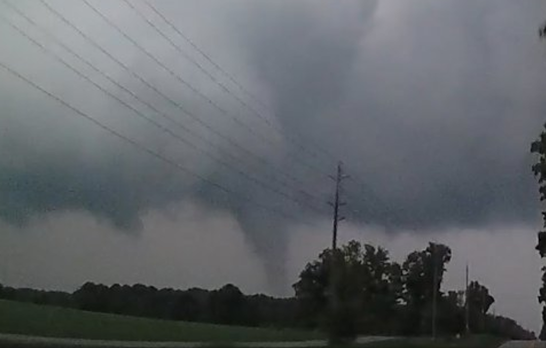
(Photo above courtesy of Dr. Dave Sills)
Below this Environment Canada's summary is a forecast and alert timeline of the event. Here's what EC wrote:
"Weather summary for Ontario and the National Capital Region issued by Environment Canada at 1:31 p.m. EDT Tuesday 28 August 2018.
Discussion.
Ontario Storm Prediction Centre confirms a tornado touched down August 27th.
The following is a summary of weather event information received by Environment Canada.
Location: Guthrie to Oro Station and possibly across Lake Simcoe
Event Description: A severe thunderstorm spawned a tornado at 8:05 PM EDT just north of Barrie yesterday, August 27th, with numerous eye witnesses providing photos and videos. The tornado had a maximum path width of 200 metres and a track length about 5 kilometres. The severe thunderstorm developed just east of Wasaga beach and tracked north of Barrie, across Lake Simcoe and towards Lindsay. Based on the damage survey by Environment Canada the tornado is rated as an upper end EF-0 with maximum wind speeds of 120 kilometres per hour.
Damage reports are being compiled and some of the reports include:
-
Tree damage
-
20m tall metal communication tower broken in half
- Damage to small structures and fences
This report will be updated as new information becomes available.
There were additional storm last evening north of Lake Ontario. If anyone experienced significant damage from last evenings storms it can be reported through an email to ONstorm@canada.ca or tweet reports using #ONStorm.
Please note that this summary may contain preliminary or unofficial information and does not constitute a complete or final report.
End/OSPC"
Forecast and alert timeline:
12:20pm, Sunday, August 26th:
We issued a preliminary forecast 31 hours in advance highlighting Oro and Guthrie in a Strong 3/5 orange severe region and mentioning the difficulty of the forecast based on the potential for no storms to actually occur:
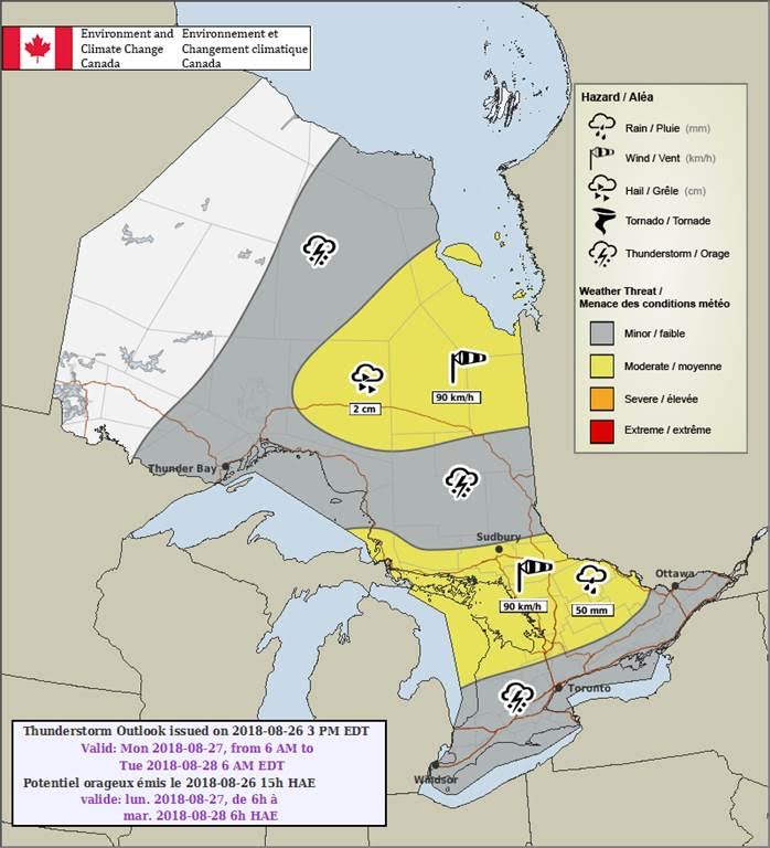
3:33pm, Sunday, August 26th:
Environment Canada issued a preliminary forecast 28 hours in advance highlighting Oro and Guthrie in a "moderate" 2/4 yellow risk region for damaging winds and flooding:
10:44am, Monday, August 27th:
Environment Canada updates their forecast map. They did include a tornado risk but only for northeastern Ontario in the overnight hours. Oro and Guthrie forecast remains the same:
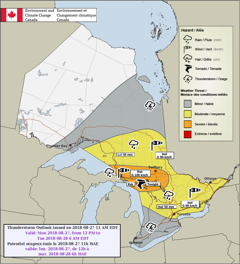
2:30pm, Monday, August 27th:
We narrowed down the severe weather forecast roughly 5 hours before the tornado and continued to highlight Oro and Guthrie in a Strong 3/5 orange severe region:
5:09pm, Monday, August 27th:
Environment Canada issues a Severe Thunderstorm Watch for Oro and Guthrie and areas to the east for large hail, damaging winds & torrential rainfall:
6:52pm, Monday, August 27th:
The day was getting late and we posted that the event was becoming increasingly less likely to happen. However, we didn't fully call it off and we highlighted the target region, which included Oro and Guthrie:
7:20pm, Monday, August 27th:
28 minutes later, we noticed a strong storm moving east, southeast off of Georgian Bay and mentioned hail and strong wind gusts. This would ultimately be the storm that produced the tornado not long after:
7:29pm, Monday, August 27th:
Environment Canada issued a Severe Thunderstorm Watch for the storm:
7:38pm, Monday, August 27th:
We posted "Minor Rotation Detected (Low Tornado or Wind Damage Risk)":

7:39pm, Monday, August 27th:
Environment Canada issues a Severe Thunderstorm Warning for the storm mentioning very strong wind gusts and hail:
7:46pm, Monday, August 27th:
We posted a radar update mentioning "Rotation on this storm heading towards Hwy 11 north of Barrie. SEEK SHELTER IMMEDIATELY":
7:48pm, Monday, August 27th:
We posted a significant update mentioning "Strong Rotation Detected (Tornado or Wind Damage Likely)":
7:50pm, Monday, August 27th:
Environment Canada issued a Tornado Warning:
8:06pm, Monday, August 27th:
Mark Robinson from The Weather Network live streams the tornado touching down in Oro:
Here's Adam's live stream while the tornado was occurring:
And here's some more videos and photos of the tornado and damage:
Thankfully, we haven't heard of any injuries or significant damage!
So glad everyone stayed safe during this tornado and kudos to Environment Canada for their timely Tornado Warning!
<3