Tropical Storm Warning Issued
the N.W.S.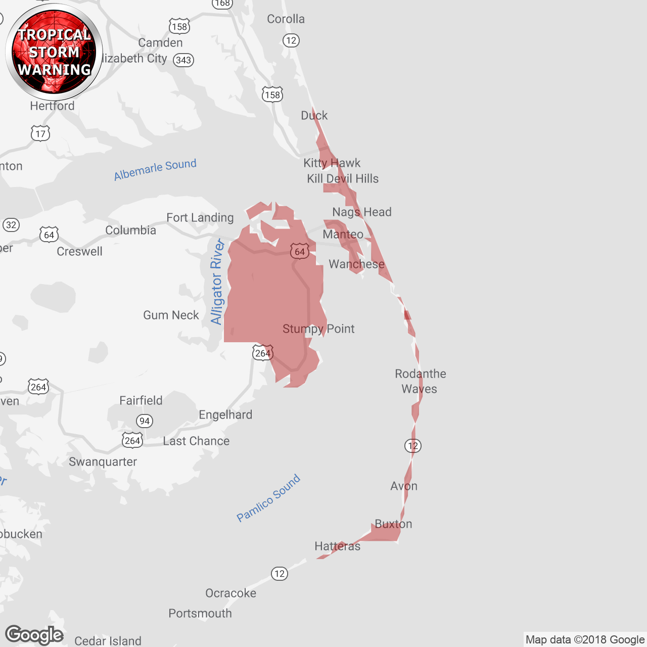
(Locations listed below description)
...TROPICAL STORM WARNING REMAINS IN EFFECT... ...STORM SURGE WATCH REMAINS IN EFFECT...
- LOCATIONS AFFECTED
- Kill Devil Hills
- Manteo
- Buxton
- WIND
- LATEST LOCAL FORECAST: Equivalent Tropical Storm force wind
- Peak Wind Forecast: 35-45 mph with gusts to 55 mph
- Window for Tropical Storm force winds: early Thursday afternoon until early Friday morning
- POTENTIAL THREAT TO LIFE AND PROPERTY: Potential for wind 39 to 57 mph
- The wind threat has remained nearly steady from the previous assessment.
- PLAN: Plan for hazardous wind of equivalent tropical storm force due to possible forecast changes in track, size, or intensity.
- PREPARE: Remaining efforts to protect property should be completed as soon as possible. Prepare for limited wind damage.
- ACT: Move to safe shelter before the wind becomes hazardous.
- POTENTIAL IMPACTS: Limited
- Damage to porches, awnings, carports, sheds, and unanchored mobile homes. Unsecured lightweight objects blown about.
- Many large tree limbs broken off. A few trees snapped or uprooted, but with greater numbers in places where trees are shallow rooted. Some fences and roadway signs blown over.
- A few roads impassable from debris, particularly within urban or heavily wooded places. Hazardous driving conditions on bridges and other elevated roadways.
- Scattered power and communications outages.
- STORM SURGE
- LATEST LOCAL FORECAST: Life-threatening storm surge possible
- Peak Storm Surge Inundation: The potential for 2-4 feet above ground somewhere within surge prone areas
- Window of concern: through early Saturday morning
- POTENTIAL THREAT TO LIFE AND PROPERTY: Potential for storm surge flooding greater than 3 feet above ground
- The storm surge threat has remained nearly steady from the previous assessment.
- PLAN: Shelter against life-threatening storm surge of greater than 3 feet above ground.
- PREPARE: Flood preparations and ordered evacuations should be complete. Evacuees should be in shelters well away from storm surge flooding.
- ACT: Remain sheltered in a safe location. Do not venture outside.
- POTENTIAL IMPACTS: Unfolding
- Potential impacts from the main surge event are unfolding.
- FLOODING RAIN
- LATEST LOCAL FORECAST: Flash Flood Watch is in effect
- Peak Rainfall Amounts: Additional around 1 inch
- POTENTIAL THREAT TO LIFE AND PROPERTY: Potential for localized flooding rain
- The flooding rain threat has remained nearly steady from the previous assessment.
- PLAN: Emergency plans should include the potential for localized flooding from heavy rain.
- PREPARE: Consider protective actions if you are in an area vulnerable to flooding.
- ACT: Heed any flood watches and warnings.
- POTENTIAL IMPACTS: Limited
- Localized rainfall flooding may prompt a few evacuations.
- Rivers and tributaries may quickly rise with swifter currents. Small streams, creeks, canals, and ditches may become swollen and overflow in spots.
- Flood waters can enter a few structures, especially in usually vulnerable spots. A few places where rapid ponding of water occurs at underpasses, low-lying spots, and poor drainage areas. Several storm drains and retention ponds become near-full and begin to overflow. Some brief road and bridge closures.
- TORNADO
- LATEST LOCAL FORECAST:
- Situation is somewhat favorable for tornadoes
- POTENTIAL THREAT TO LIFE AND PROPERTY: Potential for a few tornadoes
- The tornado threat has remained nearly steady from the previous assessment.
- PLAN: Emergency plans should include the potential for a few tornadoes.
- PREPARE: If your shelter is particularly vulnerable to tornadoes, prepare to relocate to safe shelter before hazardous weather arrives.
- ACT: If a tornado warning is issued, be ready to shelter quickly.
- POTENTIAL IMPACTS: Limited
- The occurrence of isolated tornadoes can hinder the execution of emergency plans during tropical events.
- A few places may experience tornado damage, along with power and communications disruptions.
- Locations could realize roofs peeled off buildings, chimneys toppled, mobile homes pushed off foundations or overturned, large tree tops and branches snapped off, shallow-rooted trees knocked over, moving vehicles blown off roads, and small boats pulled from moorings.
- FOR MORE INFORMATION:
- http://ready.gov/hurricanes
ISSUED:
- Mainland Dare County
- Outer Banks Dare County