Messy System to Bring a Taste of Winter to Southern Ontario With the Risk of Snow Squalls Around Georgian Bay
InstantWeather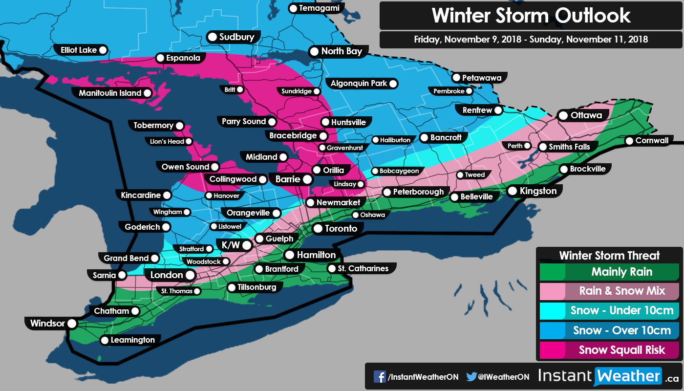
It was only a matter of time until we had to start talking about winter-like weather. That time has arrived this weekend as we’re watching a system coming out of the American Midwest that’s expected to deliver a messy mix of precipitation across our region starting Friday afternoon. In the traditional ‘snow belt’ region around Georgian Bay, we could see some intense snow squalls develop during the weekend in the wake of the system. This could result in very localized significant snowfall accumulation in some regions.
The first bands of precipitation are expected to reach extreme Southwestern Ontario (Windsor, Chatham-Kent etc.) early tomorrow morning and will likely be mostly rain in that area with temperatures a few degrees above the freezing mark. As the precipitation works its way further north it’ll encounter colder air and then snow will become the more predominant precipitation type, especially in the higher elevations to the north of London. The only exception to this will be along the Lake Erie and Lake Ontario shorelines and out towards the US border in Eastern Ontario where it’s expected to be warm enough to see mainly rain though a few flurries can’t be ruled out.
The heaviest snowfall where we could see some decent accumulation over 10cm will be confined to areas around Lake Huron, Georgian Bay and extending up to the Quebec border. Now, it’s questionable exactly how much accumulation these areas will see and will be highly variable due to the fact that some melting and compacting could occur and reduce the apparent accumulation on the ground. For this reason, we’ve decided to not produce an actual snowfall accumulation map and instead stick with a more broad impact map to show who has the possibility of seeing heavy snowfall, but it’s certainly not guaranteed.
After this system moves out of the region it’ll turn on the lake effect machine in particular with a southwesterly flow during the morning hour on Saturday and switching to a northwesterly flow later in the day. The southwesterly flow will favour the development of snow squalls stretching from Manitoulin Island and stretching into the Britt, Sundridge and Parry Sound areas. As mentioned above, the wind direction will shift to the south which will cause the snow squalls to follow suit delivering a brief burst of heavy snow to Muskoka, Simcoe County and the Bruce Peninsula during Saturday afternoon.
After that, the band is currently expected to fizzle out with some weak lake effect flurries remaining between Barrie and Gravenhurst throughout the rest of the day. There are some indications that more organized bands will redevelop during the evening stretching from the Bruce Peninsula to somewhere in Simcoe County. It’s unclear how strong they’ll be and that will dictate the potential snowfall accumulation that could be picked up within the hardest hit regions. It’s unclear on what will happen with the lake effect snow through Sunday and Monday so we’ll be posting a more detailed forecast if needed in the next few days.
Just a quick heads up that we’re seeing the potential for the first ‘snowstorm’ that could affect a large portion of Southern Ontario sometime during next week. There is also the potential for more periods of snow squalls throughout the week. Nothing is set in stone and it could easily change with it being 5-7 days away, but just thought we’d mention it and we’ll continue to monitor it and provide further updates as needed.
- Brennen P.