Locally Intense Snow Squalls to Bring Up to 15–30cm in Some Regions East of Georgian Bay and Lake Huron This Weekend
InstantWeather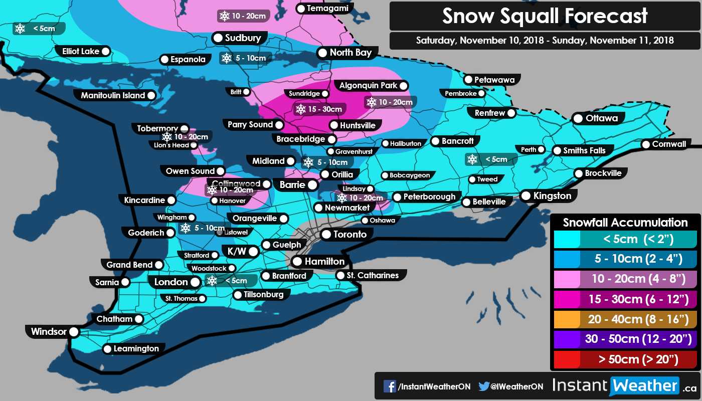
We’ve got an update on the lake effect snow expected to develop on Saturday and last well into the weekend. A fairly intense snow squall will organize early Saturday morning (2-4am) coming in from Georgian Bay somewhere just north of Parry Sound and stretching inland as far as Hwy 11 north of Huntsville.
Some locations may be locked into the strong squall for up to 3-6 hours and with snowfall rates approaching 3-5cm per hour the accumulation could quickly add up by the time you wake up. 15-20cm seems to be the general amount that can be expected within this area though extremely localized accumulation may approach 30cm should a strong squall lock into a particular region for multiple hours. The wind direction will change during the mid-morning hours (6-8am) causing the squall to slowly drift to the south bringing brief white-out conditions to regions such as the Bruce Peninsula, Muskoka and Simcoe County throughout the late morning into the afternoon.
The squall itself will be slowly weakening as it works its way down south so higher accumulation (10-15cm; locally 20cm) is expected in Muskoka and the northern section of the Bruce Peninsula with lower amounts (5-10cm) further south for the rest of the Bruce Peninsula and Simcoe County. The remnants of the squall could reach as far south as the northern GTA and affect travel along the Hwy 400 corridor though accumulation will be limited to at most 5cm.
A second round of lake-effect snow or local snow squalls are expected to develop late Saturday targeting an area southeast of Georgian Bay just north of Barrie (Barrie itself looks to be unaffected for the most part at this point) and from Lake Huron extending into Grey county. This round doesn’t appear to be as organized with multiple weaker bands coming off the lakes so accumulation should be limited to 10-15cm with local amounts approaching 20cm. All the lake effect snow activity should come to an end by Sunday morning as the wind direction changes.
More lake effect snow is possible as we get into Monday with the potential for an even stronger period of snow squalls later in the week targeting those east and southeast of Georgian Bay and Lake Huron. More details on that as it develops.
- Brennen P.