VIDEO UPDATE: Major Winter Storm for Parts of Southern Ontario Between Saturday and Sunday; Widespread 15–30cm Snowfall Accumulation for GTA, Southwestern & Eastern Ontario With Locally 40+cm in the Niagara Region
InstantWeather
The snow has already begun in areas around Lake Erie and Ontario this morning and will slowly spread throughout the rest of the region by early this afternoon. Typically we do not wait until the storm has started to issue our final forecast, but this one, in particular, has been quite difficult to nail down. Just last night it looked like we would have to downgrade the forecast as models had the system tracking further south than before. Good thing we waited because models this morning has shifted significantly back to the north with the potential for heavy snowfall extending from Windsor through Toronto and up into Ottawa.
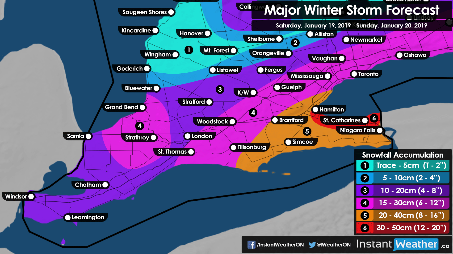
When it comes to expected accumulation, the gradient is very tight so for example, Barrie isn’t expected to get much from this system with accumulation less than 5cm. The accumulation will rapidly increase the further southeast you go especially the Niagara, Hamilton/Stoney Creek region along with locations boarding New York in Eastern Ontario. Those areas could see 20-40cm with locally 40+cm in a small zone along the QEW between St. Catharines and Hamilton due to lake enhancement.
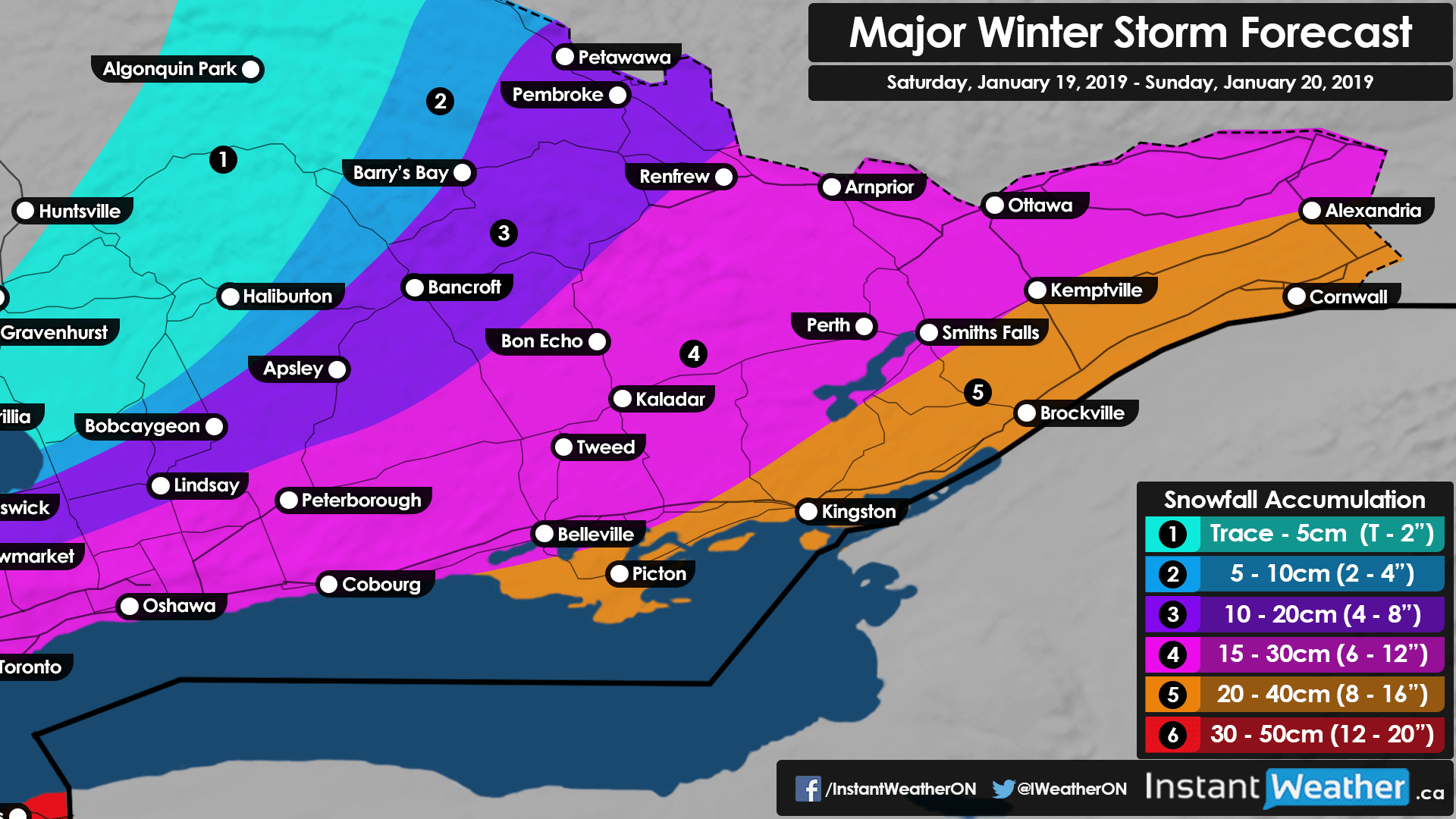
Further north, the potential for 15-30cm will exist for a fairly large region including St. Thomas, KW, the entire GTA, Peterborough and Ottawa. There is also the risk of snow squalls south of Lake Huron and Georgian Bay late Sunday. This may add an extra 5-15cm to the totals from the storm so we have bumped those regions up a level or two on our forecast map. Windsor, London, York Region and Petawawa/Pembroke will be right on the edge of this storm seeing accumulation ranging from 10-20cm though that could still be subject to some variability if the track shifts. Outside of the aforementioned areas, accumulation will drop off significantly with barely anything expected northwest of a line extending from Goderich through Barrie and up to Petawawa.
What hasn’t changed much throughout the last few days are the strong wind gusts and extremely cold temperatures that will accompany the snowfall. Firstly, wind gusts ranging from 40-60km/h will likely result in near-zero visibility out on the roads this evening into the overnight hours due to blowing snow. There is a special concern for the Niagara and Hamilton region which could see several hours of blizzard conditions and make travel extremely dangerous.
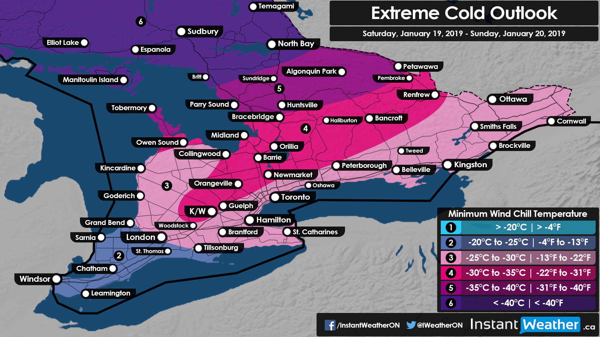
Wind chills ranging from -30°C to -40°C will present an extreme danger for those who get stranded due to the weather conditions and may be life-threatening if you're not prepared. Should you decide to travel, which wouldn’t be recommended under these conditions, it’s crucial you not only fill up your gas tank but perhaps travel with a jerrycan just in case. Also, prepare an emergency kit with warm clothing, blankets, etc. This will come in very handy should you get stranded for an extended period of time and emergency officials are unable to reach you. Also, the wind chill forecast shown here is only for this weekend and doesn’t include next week. It will be much colder than what is shown here on Monday morning and we’ll issue a forecast for that later. This system will give way to the risk of a prolonged period of snow squalls this week along with the potential for another storm during the middle of the week which we are watching very closely and will have more details soon.
Stay safe! We’ll continue to go over the latest data and keep you updated as this storm unfolds throughout the next 24 hours.
- Brennen P. , Jennifer F., Adam S.