Intense Snow Squalls to Deliver Up to 40cm of Snow to Parts of the Snowbelt in Central Ontario This Weekend; Potential for an Impactful Snowstorm for Southern Ontario Starting Monday
InstantWeather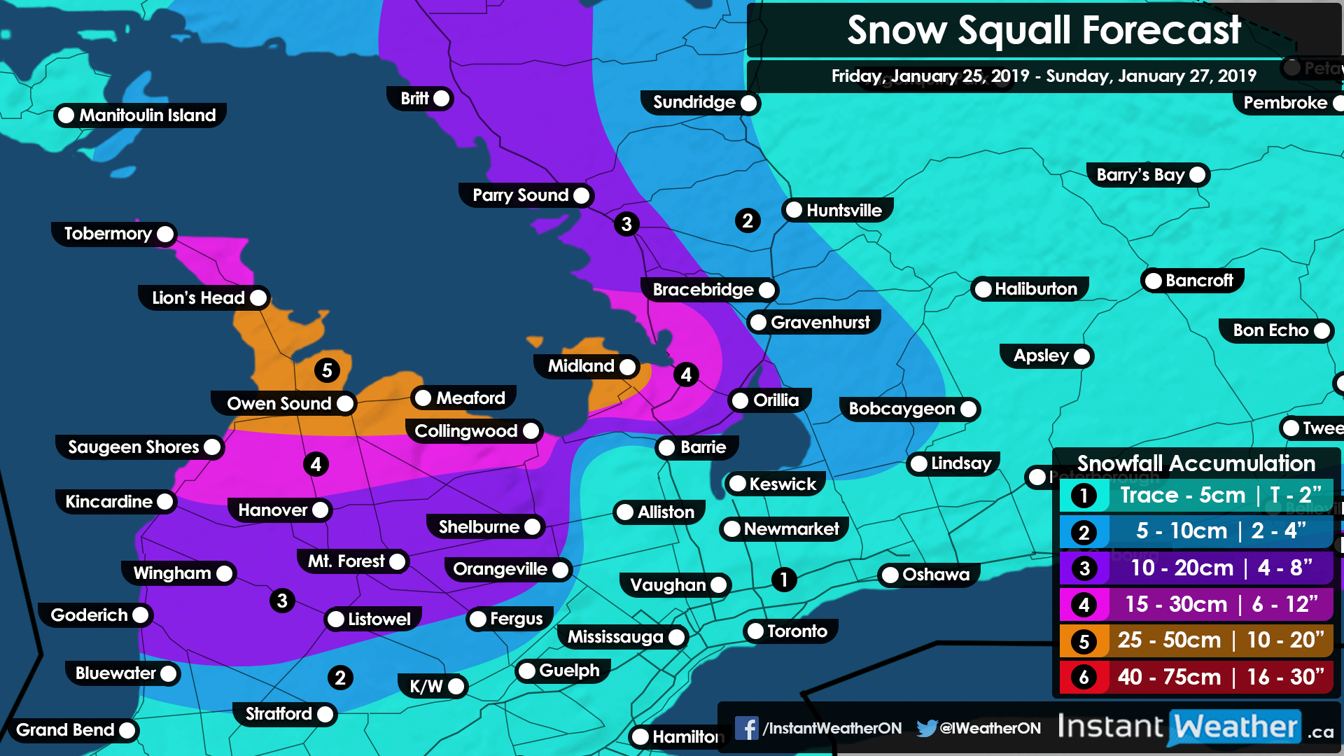
After a relatively quiet start to the winter for our region, it is feeling like Mother Nature is throwing everything at us now to make up for that. The focus, for now, will mostly be on the snow squalls that have already developed off of Lake Huron and Georgian Bay early Friday and are expected to intensify as we get into the evening and overnight hours. After the squalls weaken late on Sunday the attention will quickly turn to an approaching system from the Prairies that should begin to affect our region sometime Monday. It will also be accompanied by a blast of arctic air encompassing much of Eastern North America for the next week with record-breaking cold temperatures possible.
As mentioned, scattered lake effect snow and local snow squalls continue this afternoon coming off of Lake Huron and Georgian Bay reaching as far inland as the GTA at times. We expect the main squall to begin to strengthen as we get into the late afternoon stretching from the Bruce Peninsula, over Georgian Bay and through northern/central Simcoe County. It may extend all the way to Lake Ontario affecting the Hwy 401 corridor between Oshawa and Cobourg for the evening commute.
There is still some uncertainty regarding the placement of the squall though we expect that the City of Barrie will be mostly unaffected aside from maybe some brief bursts of heavy snow. The heaviest accumulation in this area will likely occur somewhere between Honey Harbour and Craighurst. This area has the potential to see anywhere from 15-30cm with locally more than 30cm near Midland. Lower amounts between 10-20cm are expected for the Orillia area as we get further inland.
For the Bruce Peninsula, a zone including the southern portion along with northern Bruce-Grey County (Wiarton, Owen Sound, Meaford etc.) will see nonstop snow squalls that are not expected to let up until Saturday morning or afternoon. Another round of snow squalls this time stretching from the Bruce Peninsula and up into Parry Sound/Britt area will develop early Sunday morning lasting for much of the day. Between these two events, total accumulation could exceed 40cm or even come close to 50cm for some localized areas by Sunday evening.

Some lake effect snow will also affect many regions east of Lake Huron and as mentioned, northeast of Georgian Bay during the day on Sunday with accumulation ranging from 10-20cm. Snow squalls are also expected to affect areas east of Lake Ontario in Upstate New York and at times this squall could clip Prince Edward County with the potential for 10-20cm there as well. For everyone else, accumulation will generally be less than 10cm with most seeing barely any accumulation over the weekend outside of the snowbelt.
And now onto the potential snowstorm that we are continuing to closely track. Models at the moment are all over the place in regards to see who will see the heaviest snowfall from this system. We do know accumulation should range from 15-25cm with the potential for over 25cm possible. The snow will begin late Monday and last into Tuesday so expect widespread school bus cancellations on Tuesday if the timing remains consistent with the current data. We hope to have a preliminary forecast on the snowstorm risk and extremely cold temperatures sometime this weekend so keep a look out for that.
More details soon!
- Brennen P.