Slow-Moving Snowstorm to Bring Widespread 15–30cm of Snowfall to Southern Ontario Between Monday and Wednesday; Snow Squall ‘Outbreak’ and Potentially Record Breaking Cold Temperatures to End off January
InstantWeather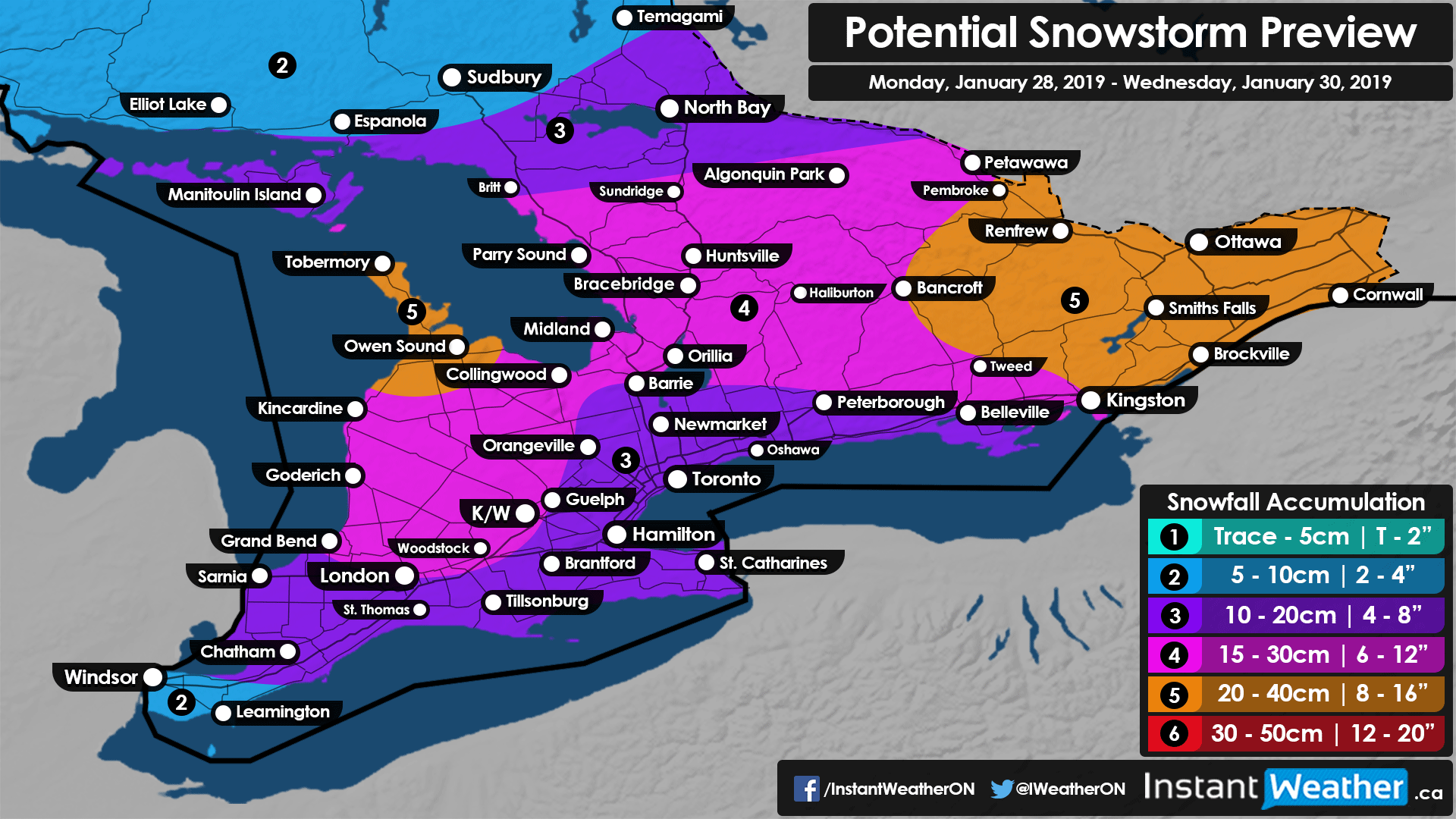
This week you will likely be wishing that you didn’t have to go outside because there really isn’t any good news when it comes to the forecast for the next 5 days. That is if you don’t like significant snow and extremely cold temperatures.
The week will begin with some lake effect snow and local snow squalls affecting the Bruce Peninsula and areas mainly east and southeast of Georgian Bay early Monday morning. Accumulation from the lake effect snow will generally range from 5-15cm, but the impacted area will be quite small. For everyone else, you will be waking up on Monday morning to chilly temperatures well into the -20’s (-10 to -20 for Southwestern Ontario) and the wind chill will make it easily feel like -30c or colder. Although, it is not expected to be as cold as last Monday where we saw the air temperature dip below -30c in many areas causing widespread school bus cancellations.
Light snow will begin to spread across our region from an approaching system moving in from Michigan starting Monday late morning in areas near Lake Huron and reaching the eastern sections by the early evening. Moderate to heavy snowfall will continue throughout much of the night and into Tuesday morning. The morning commute on Tuesday will likely be heavily impacted and we expect widespread school bus cancellations so watch for our snow day forecast Monday evening to see the chance for your area. The snow will begin to break apart during the day on Tuesday for those not in Eastern Ontario and accumulation will become much lighter by the evening.
Eastern Ontario is a different story because a secondary band of precipitation moving up the Eastern Seaboard will affect those east of a line from Belleville to Renfrew throughout late Tuesday and into Wednesday morning. The actual precipitation from this system is for the most part equally spread out through Southern Ontario. Though colder temperatures through Central and Eastern Ontario will lead to higher snow ratios than those further south and as a result, slightly more accumulation is possible. Average accumulation from this storm should end up around 15-25cm with some areas falling below or exceeding that. As mentioned, those locations that could see accumulation upwards of 25cm and perhaps as much as 40cm include the Bruce Peninsula and Eastern Ontario.
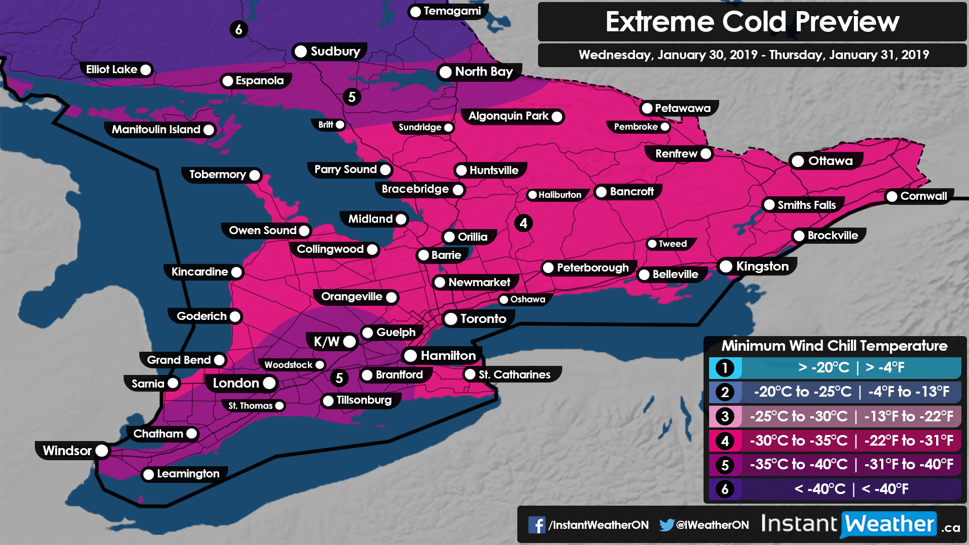
As all system related precipitation moves out of Southern Ontario by early Wednesday we will see very cold Arctic air flow into our region that won’t spare anyone lasting for the rest of the week. The coldest temperatures are expected Thursday morning with many areas getting near -30c and feeling like -40c with the wind chill. Daytime high temperatures on Thursday won’t be much better as they will struggle to get even above -20c. Long range forecast models are indicating that by next week we could be looking at temperatures above 10c (we didn’t drop the negative sign!) so this cooldown is only temporary.
We are also closely monitoring the potential for a snow squall ‘outbreak’ around Lake Huron and Georgian Bay between Wednesday and Saturday. The extremely cold temperatures will mean snow ratios will be quite high during the entire timeframe and it looks like there is the potential for squalls to lock in for 12-24+ hours at times. This could result in some locally extreme snowfall accumulation and make travel throughout the affected areas near impossible for several days. At this point, we’re not able to go into specifics on exactly who will be hardest hit and the precise snowfall accumulation though everyone in the typical ‘snowbelt’ should be prepared just in case. We’ll have more details on that in the near future as high-resolution models come into range.
- Brennen P.