Powerful Winter Storm to Impact Northern Ontario This Weekend (Feb. 23-24) With Up to 30–50cm of Snowfall, 5–10mm of Freezing Rain and Strong Wind Gusts; Blowing Snow and Local Blizzard-Like Conditions Possible
InstantWeather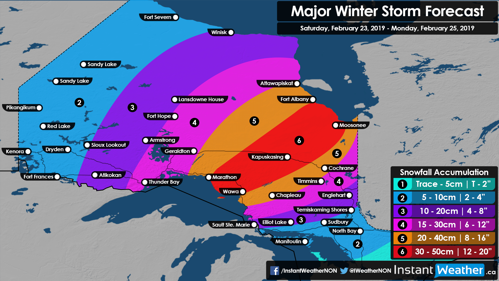
A strong system is expected to move into Northern Ontario from the US Midwest and will bring a messy mix of precipitation to the region starting Saturday and lasting into late Sunday or early Monday.
Current indications suggest that the heaviest snowfall accumulation will extend from Lake Superior and northeast towards the Quebec border. Further south there will be the risk of several hours of freezing rain for areas around Georgian Bay including Sudbury, North Bay and Elliot Lake.
Precipitation from the storm will begin as light to moderate snowfall in Northwestern Ontario during the afternoon on Saturday and spread eastward throughout the day. The biggest impacts from this storm will be felt overnight Saturday and early Sunday as very heavy snowfall moves into the region with a mix of freezing rain and ice pellets south of a line from Wawa to Temiskaming Shores. Snow will continue throughout the day on Sunday and areas that saw the freezing rain will transition over to snow as temperatures drop. By Monday morning, the system is expected to fully move out of the region.
At this point, sustained wind gusts during this event will be around 20-30km/h so the criteria for an ‘official’ blizzard (40 km/h sustained winds for 4 or more hours) will likely not be met in most areas, but blowing snow will certainly be an issue throughout Sunday as the wind picks up. This doesn’t mean that travel won’t be affected as significant snowfall is expected and blizzard-like conditions are possible even if the official criteria isn’t met.
In regards to accumulation, the hardest hit areas will include Marathon, Wawa, Kapuskasing and Moosonee where between 30-50cm is possible by Monday morning. Lower accumulation is expected east and west of this zone with Cochrane, Chapleau and Fort Albany in the bullseye for between 20-40cm of accumulation. Thunder Bay and Timmins will see between 15-30cm. Elsewhere, less than 20cm is expected due to less moisture in areas closer to the Manitoba border or more mixing near Georgian Bay. Refer to the snowfall accumulation map above for specific amounts.
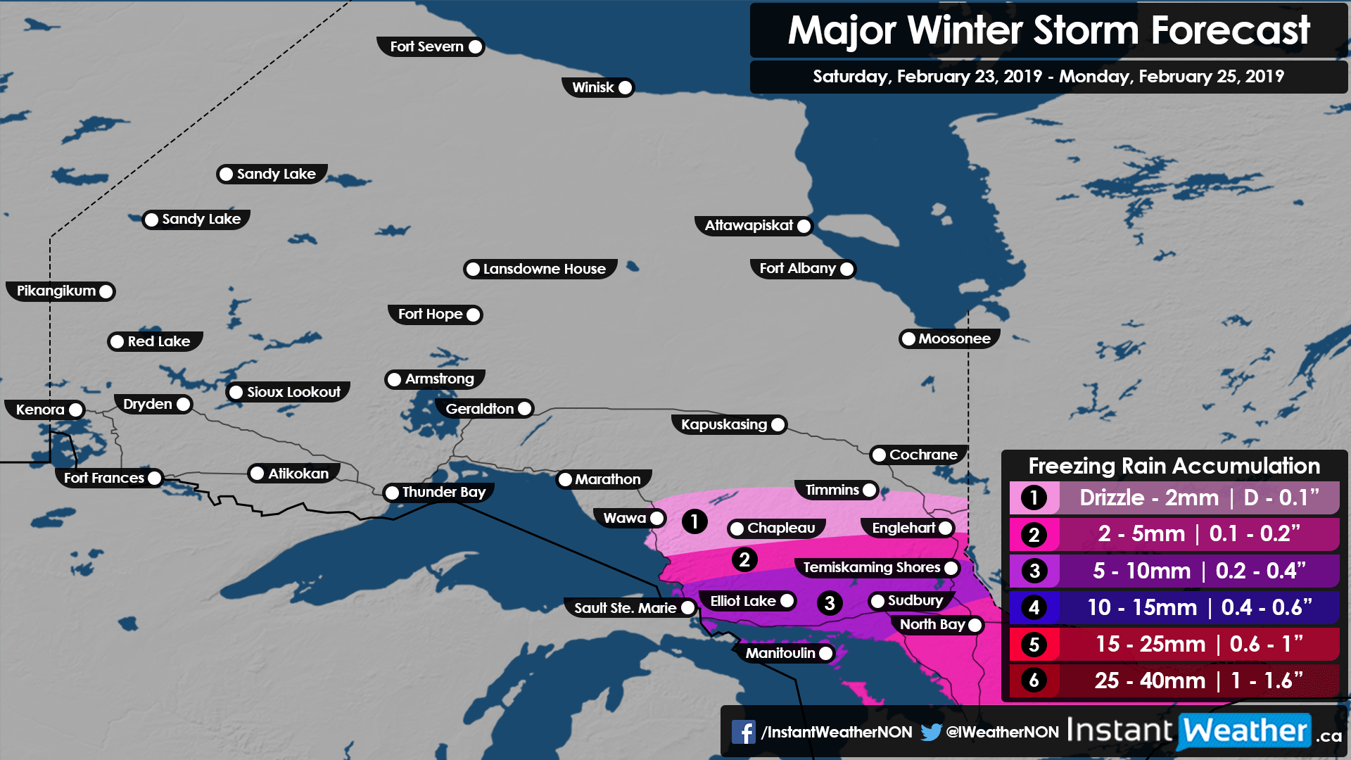
And on the topic of mixing, freezing rain accumulation should max out at around 10mm of possible ice accumulation in areas north of Georgian Bay including Sault Ste. Marie, Elliot Lake, Sudbury, North Bay and Temiskaming Shores. Obviously, less freezing rain is expected further north as snow becomes the more dominant precipitation type. There is some concern for power outages in the aforementioned area as strong wind gusts between 70-90km/h will move into the region after the heavy freezing rain later Sunday.
We’ll continue to keep an eye on the latest data and pass along any significant updates. Stay safe!
Forecaster: Brennen Perry