Messy Winter Storm Beginning Late Saturday to Bring a Mixed Bag of Precipitation to Southern Ontario; Main Risks Include 15+cm of Snow in Central Ontario, Prolonged Freezing Rain for SW Ontario and the Potential for Damaging Wind Gusts
InstantWeather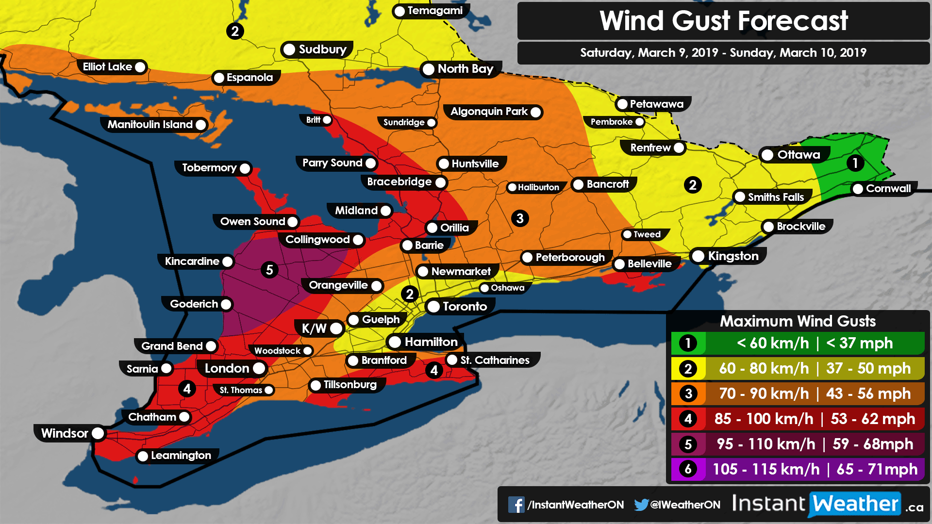
Even though we are now well into March and the start of meteorological spring it seems that winter does not want to let go just yet. After dealing with very cold temperatures (at least by March standards) throughout the last week, a warm-up is on the way in time for March Break. Although it does come at a cost of some active weather beginning early Sunday morning.
A system currently over the US Midwest is expected to approach Ontario late Saturday with the first effects being felt in the form of very strong to damaging wind gusts approaching 90km/h (100km/h near Lake Huron). The strongest wind gusts should occur mostly during the early morning hours on Sunday with the gusts becoming lighter later in the day. Most areas will max out at around 75-85km/h so this is not expected to be anywhere close to the major wind storm we saw a few weeks back. Although, the potential exists for wind gusts to reach severe levels around Lake Huron, Georgian Bay and through the Niagara Region and Prince Edward County.

Precipitation from this system will reach the far southwestern portion of the region including Windsor, Sarnia and London sometime just before midnight. It appears that temperatures will be above the freezing mark for this area as the precipitation starts so the risk for any mixing or freezing rain will be limited. As the precipitation continues to progress northward through the overnight hour a more widespread line of freezing rain and wet snow will develop as it approaches higher elevations where colder air at the surface is present. There is the potential for several hours of freezing rain in this area that includes the Dundalk Highlands, Wellington County and Kitchener-Waterloo.
Now, exactly how much freezing rain will actually stick is questionable as it looks like it will come down within a short timeframe before switching over to rain as the temperature climbs above the freezing mark. While we are forecasting a maximum of 10-15mm it is impossible to guess exactly how much will stick to surfaces especially since this is a short event so accretion may be much less. Although, combined with the 70-90km/h wind gusts expected during this time could result in some power outages and minor tree damage. The freezing rain risk will come to an end late Sunday morning.
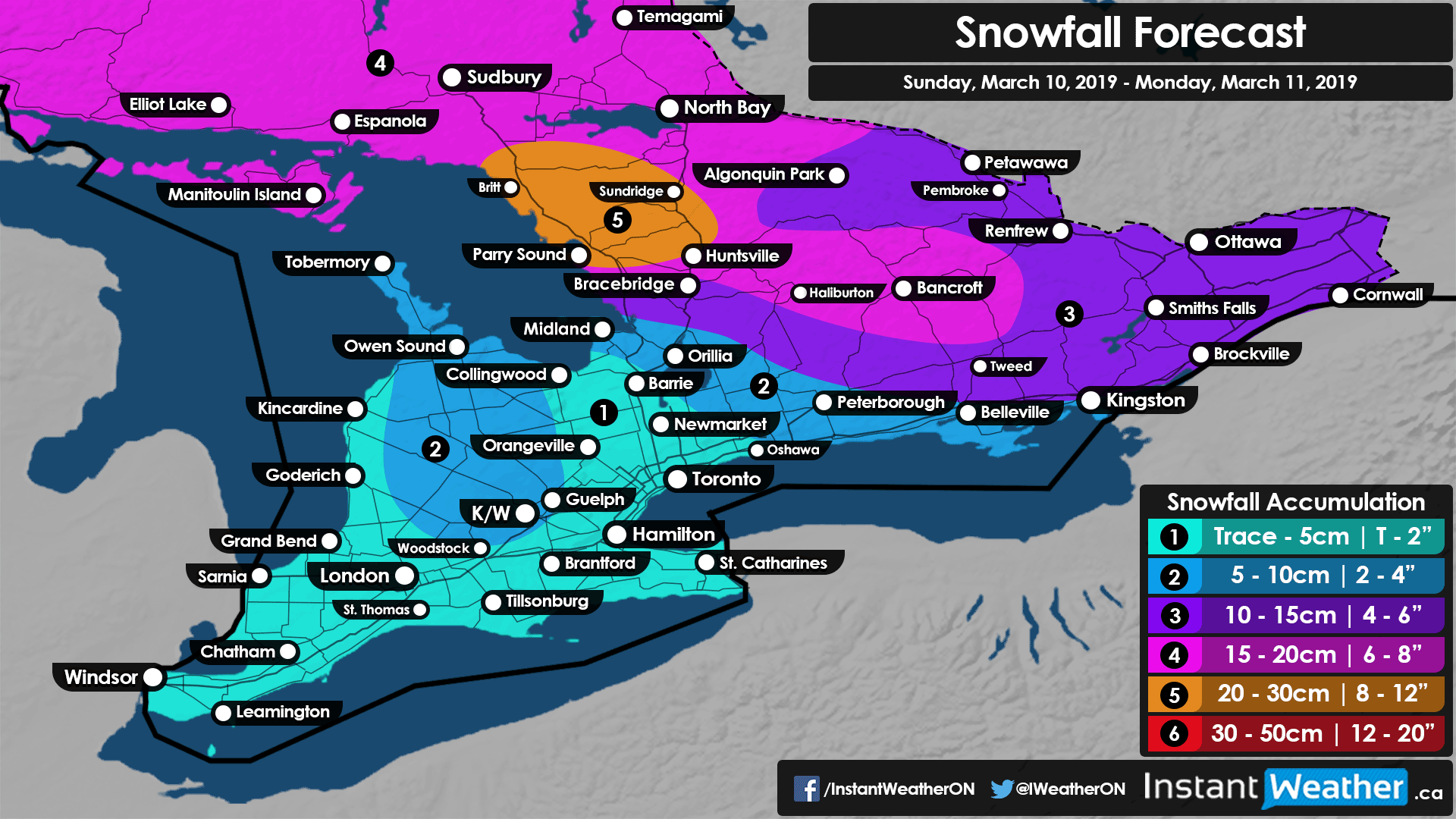
Further north, there is the potential for accumulating snow from this system along with lake effect snow that could develop late Sunday east of Georgian Bay. Most areas of Central, Northeastern and Eastern Ontario can expect to see between 10-20cm with higher amounts closer to Georgian Bay by Monday morning. Localized areas east of Georgian Bay that see the heavy lake effect snow overnight Sunday into Monday could have snowfall totals exceed the 20cm mark. The lake effect snow could continue well into Monday not letting up until late in the day so travel in that area will likely be affected.
As always, we will continue to keep an eye on this system and pass along any updates as needed.
Forecaster: Brennen Perry