UPDATE: Winter Storm Starting This Weekend to Be Stronger Than Expected Through Southern Ontario; Potential for 15–20+cm of Snow for Central Ontario, Flooding risk for Southwestern Ontario and 15–25mm of Freezing Rain in Parts of the Ottawa Valley
InstantWeather
The upcoming storm has been quite difficult to pin down because it seems that the models shift almost daily to show a totally different scenario. Earlier this week we mentioned that models were showing the potential for widespread 10-20cm of snow accumulation. In our preliminary outlook on Thursday, we decreased that down to 5-12cm which was contained mostly throughout Central Ontario.
We’ve been closely monitoring the high-resolution models and have shifted back to the higher totals, especially in the Algonquin Park area where it appears between 15-30cm is possible. Although, not much has changed regarding the freezing rain situation although concern continues to grow about a prolonged icing event in parts of the Ottawa Valley. The risk for freezing rain also exists through the Dundalk Highlands east of the GTA, but won’t be as severe as out east.
The storm will begin to move into our region early Saturday just after midnight with most of the impacts being felt during the day on Saturday. By Sunday morning, we should see precipitation coming to an end as the system moves out with Eastern Ontario continuing to be affected into Sunday afternoon.
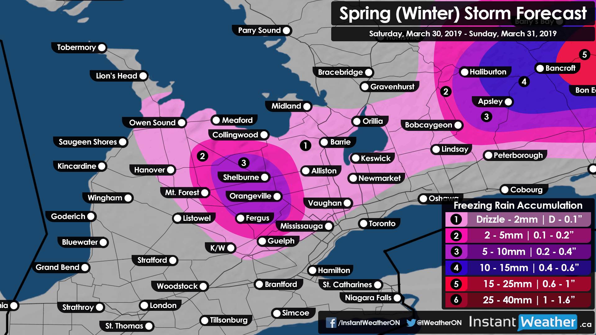
What you see from this storm will be largely dependent on your location as temperatures will be quite close to the freezing mark. As the system first reaches our region Saturday morning, the main precipitation type will be rain around Lake Ontario and Erie with a risk of brief freezing rain further north through Sarnia, London and the GTA away from the lakeshore. As we typically see with these events, slightly colder temperatures will be located in the higher elevations west of the GTA which will allow for more long-lasting freezing rain. This includes Orangeville, Fergus, Guelph and the K/W area where 4-6 hours of freezing rain is possible.
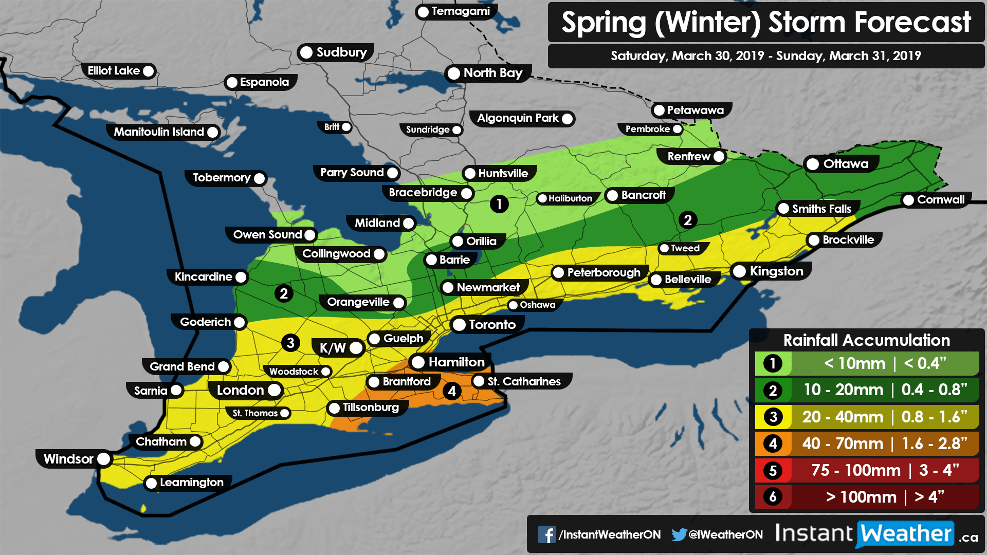
As we get into the afternoon on Saturday the precipitation will encompass all of Southern Ontario with a fairly sharp mixing line stretching from Goderich to Renfrew. Areas northwest of the mixing line will continue to see moderate to heavy snowfall. With the exception of Eastern Ontario, areas southeast of the line including the higher elevations west of the GTA will switch over to or continue to see rain as the predominant precipitation type. Flooding could be an issue in these areas as between 20-40mm of rainfall accumulation is possible with higher amounts in the Niagara region.

Now, the highest concern with this event is the potential for prolonged freezing rain for the Ottawa Valley. The environment appears favourable for freezing rain beginning late Saturday morning and continue all the way into the evening. This could result in up to 8-12 hours of constant freezing rain with precipitation quite heavy at times. Total freezing rain accumulation may be upwards of 15-25mm in some areas south of Renfrew. Although do note that typically actual ice accretion on surfaces will vary and is impossible to account for so our forecast shows the maximum amount. High impacts on travel, especially on rural roads is expected and even some power outages can’t be ruled out.
It now appears that the snow on the backside of this system after the temperatures drop towards the freezing mark late Saturday will be more extensive. Several hours of heavy wet snow could deliver a quick 6-12cm of accumulation (maybe less due to melting) to much of the Southern Ontario including the GTA. The system will begin to wind down as we go into Sunday morning. Aside from some lake effect snow around Lake Huron and Georgian Bay, most of Sunday should be precipitation-free although temperatures will be chilly with many areas remaining below the freezing mark throughout the day.
Forecaster: Brennen Perry