FLOOD WARNINGS & Provincially Issued Flood Watch In Place
InstantWeather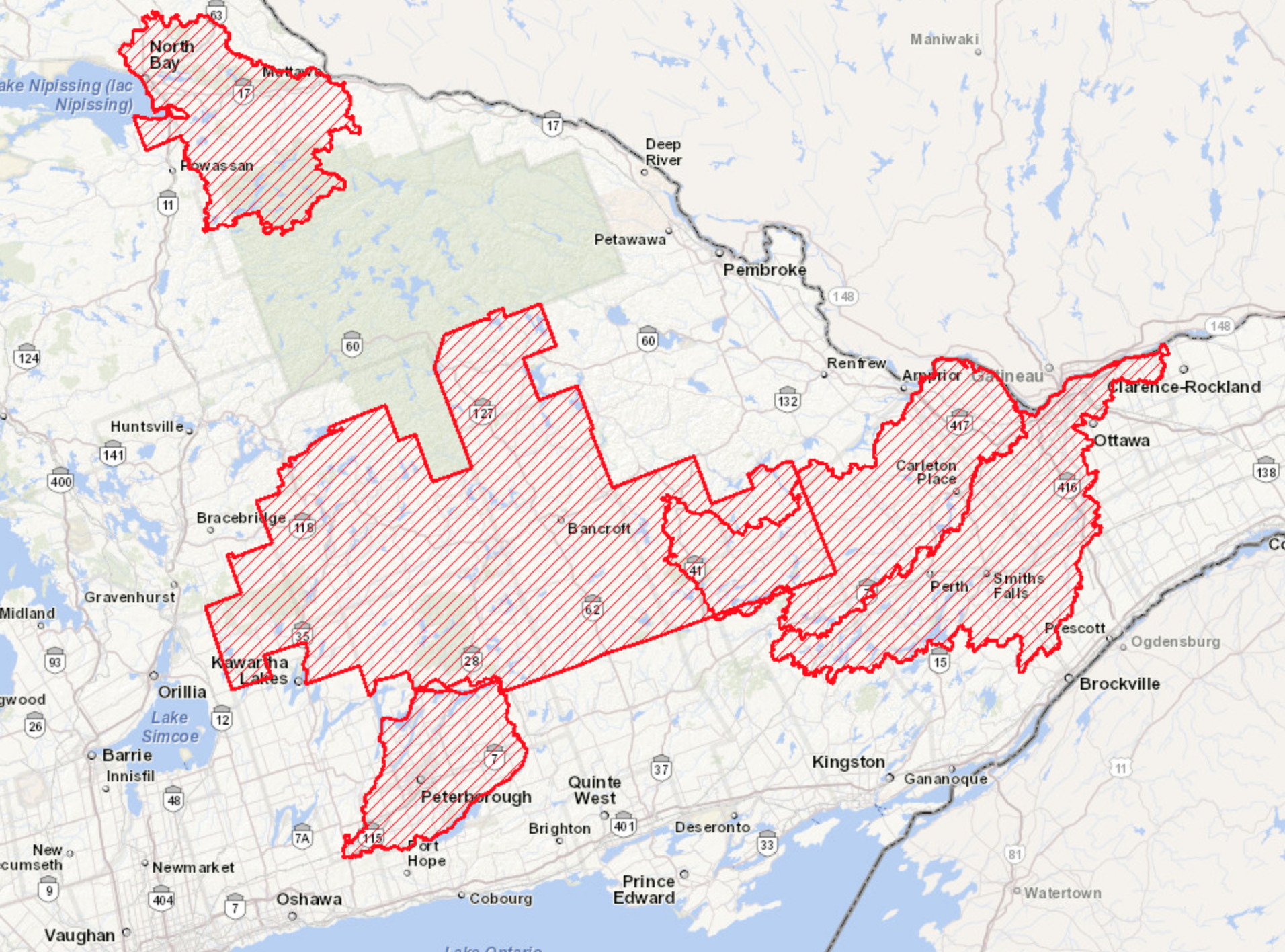
Above is the current Flood Warning areas in eastern Ontario.
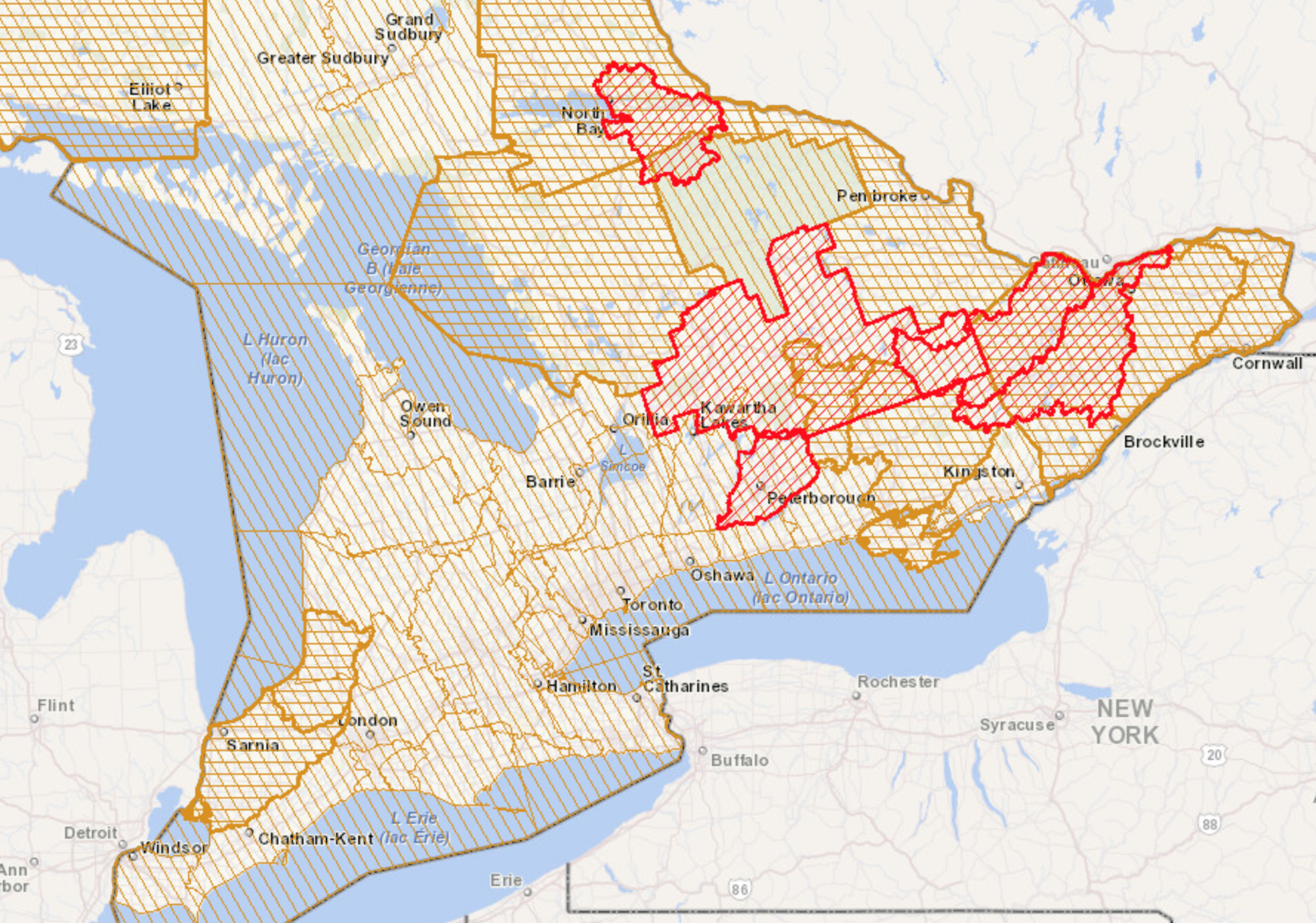
The image below, is the current Provincial Flood Watch with the Warnings and locally issued Flood Watches in thicker brown/orange:
(See further down for a list of different areas and their risk level)
Ministry of Natural Resources and Forestry (MNRF) wrote:
"Provincial Flood Watch Issued for Ontario by the Surface Water Monitoring Centre of the Ministry of Natural Resources and Forestry:
Weather Situation
A Colorado low merging with a Texas low is forecast to move in tonight (Wednesday evening) bringing significant precipitation, mostly in the form of rain, across the Province. The precipitation will begin Wednesday evening where 15 to 25 mm is forecast along the shores of the upper Great Lakes. The system is forecast to slide south on Thursday and drop 15 to 30 mm of rain across a large swath of central and southcentral Ontario. Rainfall is forecast to persist into Friday with 15 to 30 mm forecast across a large swath of southcentral, south and southeastern Ontario. The system is forecast to die out on Saturday but may still produce up to 20 mm in southwestern Ontario. Thunderstorms associated with this event are possible and may produce and additional 5 to 10 mm in isolated areas.
Totals across a broad swath of south and central Ontario in the range of 30 to 50 mm are forecast with higher amounts possible in isolated areas.
High winds associated with system in the range of 30 to 35 km/hr with stronger gusts up to 45 km/hr are forecast across the lower Great Lakes.
Daytime high temperatures are forecast in the 0 to 10 degrees Celsius range across most of the north of the Province over the next five days with forecasted highs in the 5 to 15 degree Celsius in the south. Night-time low temperatures are largely forecast to stay at or below 0 degrees Celsius in the northern part of the Province and remain at or above 0 degrees Celsius in the southern parts of the Province.
Mid-April snow surveys show a continuing snowpack in central and northeastern Ontario ranging from 100 to 200 mm of snow water equivalent in central Ontario and 100 to 250 mm in northeastern Ontario. These values are above average to well above average for this time of year.
Risks
Water levels and stream flows across southern and central Ontario are elevated from ongoing spring snow melt and past precipitation events.
The impact of recent warm temperatures and rainfall have compacted and ripened the significant snow pack reducing its ability to absorb rainfall. The forecast warm temperatures and precipitation are likely to further degrade the snowpack and river ice, produce significant runoff and further increase levels and flows.
Risks may include degradation of river ice and ice jam related flooding from increasing temperatures and flows, fast moving cold water with rapidly changing conditions, and flooding of low-lying areas.
The Ottawa River Regulating Committee forecast that flows are expected to exceed minor flood levels over the Easter Weekend. A close watch on local forecasts and conditions is recommended."
Here are the current levels from Outlook > Statement > Watch > Warning:
MNRF Districts
-
Bancroft - Flood Warning and Flood Watch
-
Cochrane - Watershed Conditions Statement – Flood Outlook
-
Kemptville - Flood Watch
-
Midhurst - Watershed Conditions Statement – Flood Outlook
-
North Bay - Flood Watch
-
Parry Sound - Flood Watch
-
Pembroke - Flood Watch
-
Sault Ste. Marie - Flood Watch
- Sudbury - Watershed Conditions Statement – Flood Outlook Manitoulin
Conservation Authorities
-
Ausable Bayfield - Flood Watch
-
Cataraqui Region - Watershed Conditions Statement – Flood Outlook
-
Central Lake Ontario - Watershed Conditions Statement – Flood Outlook
-
Credit Valley - Watershed Conditions Statement – Flood Outlook
-
Crowe Valley - Flood Watch
-
Ganaraska Region - Watershed Conditions Statement – Flood Outlook
-
Grand River - Watershed Conditions Statement – Water Safety
-
Halton Region - Watershed Conditions Statement – Flood Outlook
-
Hamilton Region - Watershed Conditions Statement – Flood Outlook
-
Kawartha Region - Watershed Conditions Statement – Flood Outlook
-
Kettle Creek - Watershed Conditions Statement – Water Safety
-
Lake Simcoe Region - Watershed Conditions Statement – Flood Outlook
-
Long Point Region - Watershed Conditions Statement – Water Safety
-
Lower Trent - Watershed Conditions Statement – Flood Outlook
-
Mississippi Valley - Flood Warning and Flood Watch
-
Niagara Peninsula - Watershed Conditions Statement – Flood Outlook
-
North Bay Mattawa - Flood Warning
-
Nottawasaga Valley - Watershed Conditions Statement – Water Safety
-
Otonabee Region - Flood Warning
-
Quinte - Flood Watch
-
Raisin Region - Watershed Conditions Statement – Flood Outlook
-
Rideau Valley - Flood Warning and Flood Watch
-
Sault Ste. Marie Region - Watershed Conditions Statement – Water Safety
-
South Nation River - Flood Watch and Flood Outlook
- St. Clair Region - Flood Watch
Toronto and Region - Watershed Conditions Statement – Flood Outlook
- Upper Thames River - Watershed Conditions Statement – Water Safety
River Regulatory Agencies
-
Trent Severn Waterways - Water Level Management Update
- Ottawa River Regulation Planning Board - Rising Levels
Please let us know what you know! Be safe if you're near these particular waterways over the next couple days. <3
- Adam
P.S. Please consider joining our Patreon campaign! For more details, visit https://Patreon.com/InstantWeather - There are cool rewards there like our instant Text Message Alerts, t-shirts and coffee mugs, etc! Thank you!