Threat of Severe Thunderstorms for Eastern Ontario on Thursday with Main Risks Including Damaging Wind Gusts and Large Hail
InstantWeather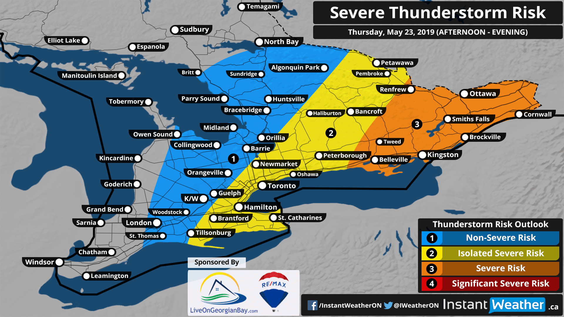
This forecast is sponsored by ReMax Four Seasons Realty Limited! A real estate agent that knows the local market and will work hard with you every step of the way. Driven to exceed your expectations! Buy or Sell in Collingwood, Thornbury, the Blue Mountains, Wasaga Beach, Meaford, Creemore, Stayner, Grey Highlands and surrounding areas. You can find out more here: liveongeorgianbay.com
If you're interested in connecting your organization with our amazing community by sponsoring a forecast map, please visit: instantweatherinc.com/sponsor
While it took what felt like forever for summer-like weather to arrive, this week will certainly feel like summer! Temperatures will be consistently in the high teens to 20’s for the rest of the week and a severe thunderstorm threat for Eastern Ontario on Thursday. It appears that this will only be a taste of what’s to come with a fairly active period expected next week.
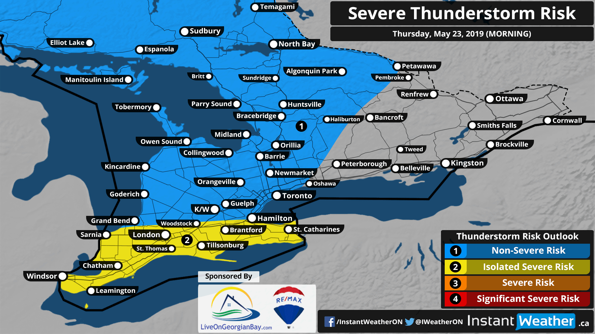
The active weather will begin early Thursday morning as a decaying line of thunderstorms approaches Southwestern Ontario. For the most part, the storms should remain non-severe with the exception of areas north of Lake Erie which could see near severe wind gusts up to 90km/h. There could also be some thunderstorm development just after midnight for the Elliot Lake/Sudbury region although any storms will be rather weak given the lack of convective energy available.
In general, more of Southern Ontario will be dry throughout the day with the possibility of a passing shower throughout the afternoon. A more potent round of strong to severe thunderstorms is expected for Eastern Ontario with a particular focus on the Ottawa Valley during the late afternoon or evening.
The environment is favourable for the development of discrete storms along a line extending from about Renfrew to Belleville sometime between 3-5pm as they track to the east. These storms may pose a damaging wind gust and/or large hail risk throughout their lifespan. Current data indicates the potential for tornadic activity especially around the Ottawa and surrounding area between 4-8pm. Although that isn't for certain and may change as we go over the evening and morning model data.
A more questionable severe risk for regions further west including parts of Central Ontario and the GTHA will be present during the afternoon hours. It looks like storm development is unlikely to occur early enough in the afternoon for the risk to materialize so we've gone with an isolated severe risk on our forecast map.
Also, important to note if you’re travelling stateside through New York or Pennsylvania tomorrow, a strong risk for severe thunderstorms exist for that area as well. The Storm Prediction Centre has issued an ‘enhanced’ risk covering much of Central and Eastern Pennsylvania warning of “storms [that] may produce large hail, damaging wind and a couple of tornadoes”.
We’ll continue to follow this situation closely and have a more detailed forecast on what areas have the highest probability of severe storms sometime tomorrow morning or early afternoon. Be sure to check back for the very latest information!
Forecaster: Brennen Perry