Funnel Cloud & Potential Tornado Video From Thursday's Storm in Pembroke, ON
InstantWeatherJoan B. sent the video above to us of a funnel cloud with quite a bit of motion near Pembroke, Ontario from yesterday, Thursday, July 11th, 2019.
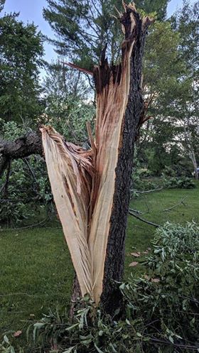
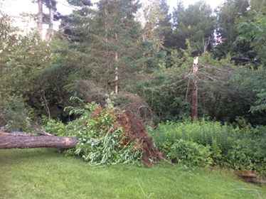
We've also received a damage report, associated with the same storm in Pembroke. Helen H.B. writes "We were hit yesterday July 11th..." "Many huge mature trees uprooted and tops snapped off. No damage to our home. Trees fell all around it. We are very fortunate."
We're so glad you stayed safe Helen!
Helen also shared these and many other images with us:

Additionally, radar showed an isolated supercell (rotating storm) in the Pembroke area at this same time. Kudos to Michael Chambers @205mph for initially recognizing that rotation had occurred on the very edge of Franktown radar:
Unfortunately, there is no quality velocity (wind speed) radar data available for Pembroke, Petawawa, Algonquin, etc., and ultimately, there is no way of recognizing rotation for those communities at this point. Thankfully, Environment Canada is upgrading all of their radar stations over the next few years and once Franktown is completed, this area will have much better coverage!
We shared this evidence with Dr. David Sills from the Northern Tornadoes Project and thankfully, Dr. Sills let us know that Pembroke has been added to the NTP's ongoing investigation:
"An NTP team will be investigating several reports of damage, including the report in Pembroke, associated with Thursday's storms."
Did anyone else witness this? If you have videos, photos, and/or any damage reports, please let us know and we'll pass them along to Environment Canada and the Northern Tornadoes Project.
Thankfully, we haven't heard reports of injuries and hopefully, everyone stayed safe with Thursday's storms!
- Adam