Dangerous Heatwave and Severe Thunderstorm Potential on the Horizon for Southern Ontario This Weekend; Humidex Will Make It Feel Like the Low to Mid 40s on Friday and Saturday
InstantWeather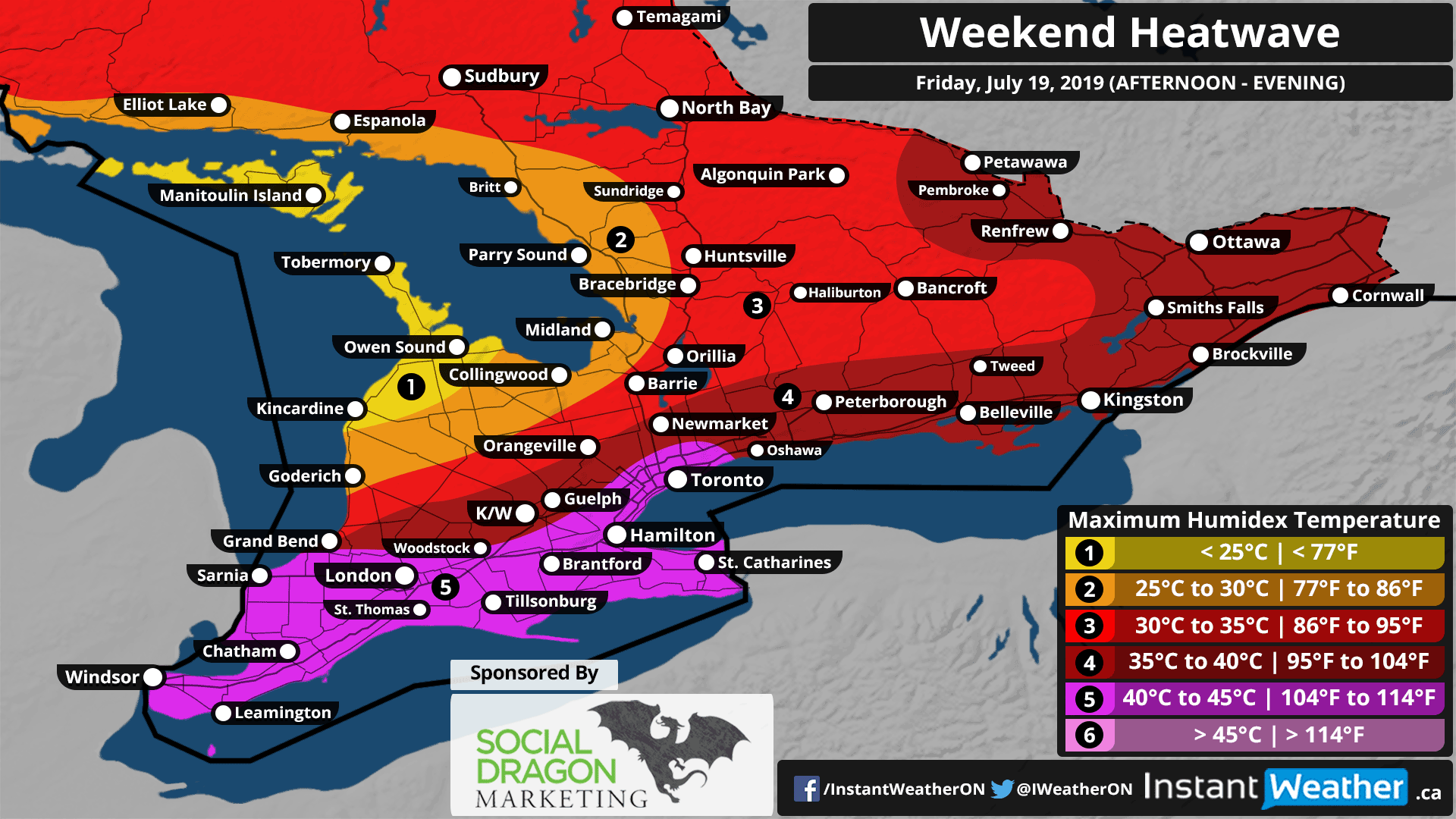
Sponsor
This forecast is sponsored by Social Dragon Marketing! Are you a business owner? You probably already have enough on your plate. Social Media Marketing shouldn’t be one of them. The good news… you don’t have to do it all! Social Dragon Marketing can manage your day-to-day social media marketing activities by using the right tools designed for your business needs. You can find out more here: socialdragonmarketing.com
If you're interested in connecting your organization with our amazing community by sponsoring a forecast map, please visit: instantweatherinc.com/sponsor
Forecast
Considering we are in the middle of the summer it should not surprise anyone that extremely hot temperatures are in the forecast. Although, the start of this summer, in particular, was quite cool and have yet to experience a widespread heatwave into July. The last few weeks have been more closely to what we expect from summer with daytime temperatures frequently into the 20s and 30s. That trend will continue into this weekend with what likely will be the hottest temperatures we have experienced so far this summer.
This will all begin starting on Friday as hot and humid air pushes into Southern Ontario resulting in daytime temperatures before you factor in the humidex exceeding 30°C across much of Southwestern, Central and Eastern Ontario. The hotspot in the province is expected to be located in Extreme Southwestern Ontario (Windsor, Sarnia, Leamington etc.) where the temperature without the humidex could get close to 35°C.
Now, with the humidex, it will feel like 40-45°C in a zone including Extreme Southwestern Ontario and the GTHA. Outside of that zone, the humidex will be marginally more comfortable although still dangerous ranging between 30-40°C depending on your location. Areas closer to the Lake Huron and Georgian Bay shoreline will be slightly colder thanks to lake breezes with the humidex between 25-35°C. Refer to the map above for your specific local details.
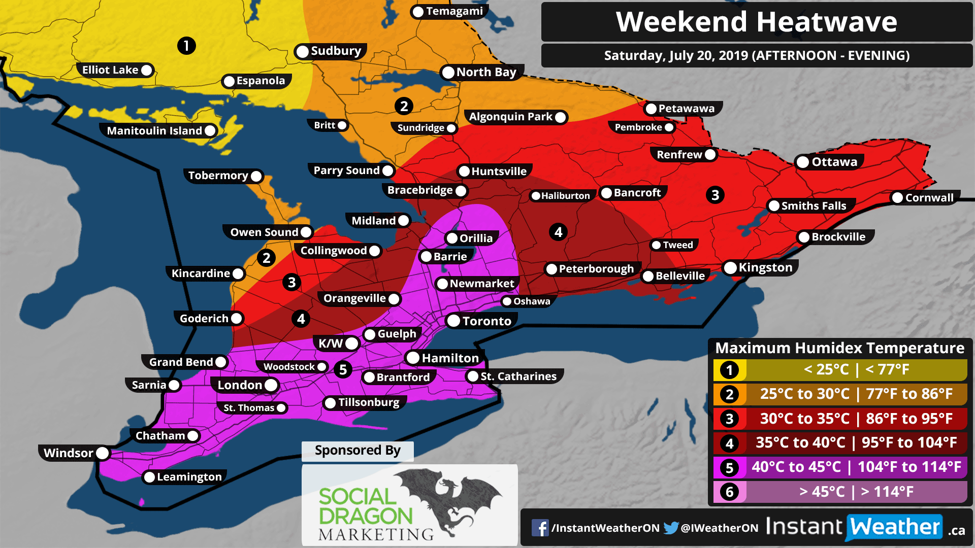
Some relief is expected overnight Friday as the temperature drop by about 10°C to between 15-25°C. Although that will be short-lived because the heat will build back in during the day on Saturday. Similar daytime highs to Friday can be expected with some minor differences, in particular, a larger 40-45°C zone including parts of Central Ontario and less of a cooling effect around the shorelines. Extreme Southwestern Ontario will likely yet again be the hotspot on Saturday with temperatures between 34-38°C and humidex close to 45°C.
Sunday will bring temperatures back to more manageable levels with daytime temperatures between 20-25°C and it looks to remain that way for at least into next week.
With extremely hot weather comes the increased risk of heat exhaustion and heatstroke. The most important thing that can’t be emphasized enough is DO NOT LEAVE CHILDREN OR PETS UNATTENDED INSIDE VEHICLES!!! It can get dangerously hot inside vehicles in the matter of minutes resulting in significant health problems and eventually, death. If you see an animal or child alone inside a vehicle call 911 immediately!
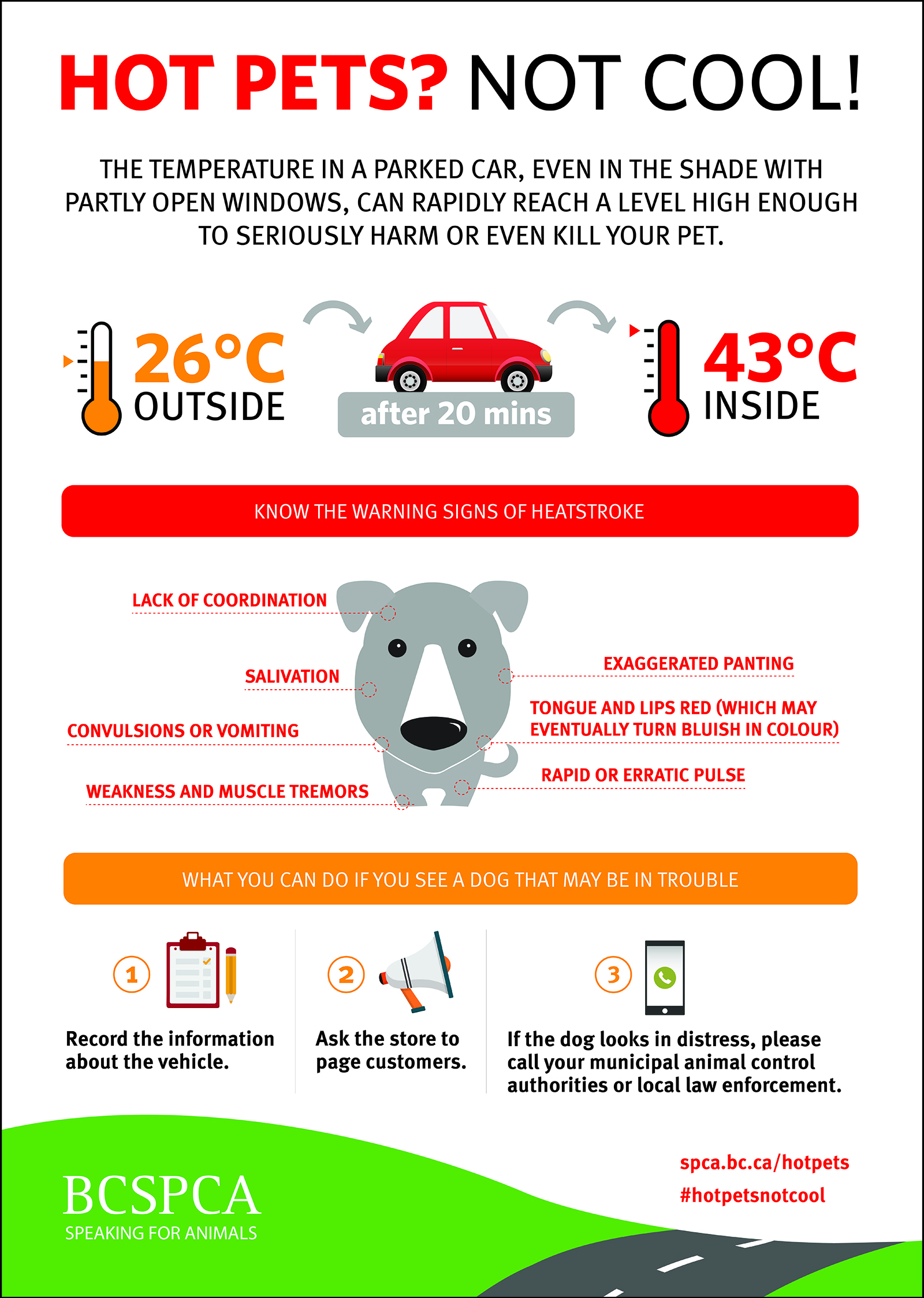
Infograph courtesy of spca.bc.ca.
Here are some safety tips courtesy of the Red Cross:
- Hot cars can be deadly. Never leave children or pets in your vehicle. The inside temperature of the car can quickly reach 120°F (50°C) degrees.
- Stay hydrated by drinking plenty of fluids. Avoid drinks with caffeine or alcohol.
- Check on family, friends and neighbours who do not have air conditioning, who spend much of their time alone or who are more likely to be affected by the heat.
- If someone doesn’t have air conditioning, they should seek relief from the heat during the warmest part of the day in places like schools, libraries, theatres, malls, etc.
- Avoid extreme temperature changes.
- Wear loose-fitting, lightweight, light-coloured clothing. Avoid dark colours because they absorb the sun’s rays.
- Slow down, stay indoors and avoid strenuous exercise during the hottest part of the day.
- Postpone outdoor games and activities.
- Use a buddy system when working in excessive heat. Take frequent breaks if working outdoors.
- Check on animals frequently to ensure that they are not suffering from the heat. Make sure they have plenty of cool water.
More can be found here: www.redcross.org
There is also the risk of thunderstorms during the afternoon and evening hours on Friday. At this point, the strongest potential exists through Southwestern Ontario with all the severe threat types including tornadoes on the table. The thunderstorm potential will shift eastward on Saturday with Central and Eastern Ontario being in the bullseye for strong storms and again all severe threat types are possible. We’re working on a more detailed forecast regarding the storm risk and will have it out shortly!
Forecaster: Brennen Perry