Messy Winter Weather Ahead This Week for Southern Ontario; Snow & Freezing Rain Risk Starting Late Tuesday


GOOGLE AD (NOT ENDORSED BY INSTANT WEATHER)

Parts of Southern Ontario are on the brink of experiencing some wintry weather this week as a system is set to sweep into the region on Tuesday. In line with this time of the year, the system will usher in a mix of wintry precipitation, including freezing rain, ice pellets, and wet snow, starting Tuesday afternoon and lingering into Wednesday morning.

As the system approaches, rain is anticipated for Southwestern Ontario and along the Lake Erie shoreline early Tuesday. However, colder temperatures northeastward, across the Dundalk Highlands and around Lake Simcoe, may lead to the development of mixed precipitation starting Tuesday afternoon.

Current indications point to a potential mix of wet snow, ice pellets, and freezing rain to the northwest of the GTA (Kitchener, Guelph, Orangeville, York Region, Barrie, etc.) during Tuesday's evening commute. Be prepared for potential travel delays due to the inclement weather.

For most regions, the impact is expected to be limited thanks to a swift transition to rain that is anticipated by Tuesday evening. However, higher elevations in the Dundalk Highlands, including Orangeville, Fergus, and Shelburne, could experience more prolonged freezing rain as temperatures struggle to rise above freezing. Regions south of Lake Simcoe are expected to switch over to rain by midnight.


GOOGLE AD (NOT ENDORSED BY INSTANT WEATHER)

Central and Eastern Ontario are likely to experience higher impacts, with the wintry mix beginning in the evening and lingering overnight into Wednesday morning. While some uncertainty exists regarding the extent of the mixed precipitation, some regions, especially in the Ottawa Valley and along the Quebec border, could see minor snowfall accumulation of up to 5-10cm.

The snow is anticipated to transition into a mix of ice pellets and freezing rain by pre-dawn on Wednesday, possibly prompting school bus cancellations in parts of Central and Eastern Ontario depending on the timing and amount of freezing rain.

All precipitation is expected to subside by Wednesday afternoon as the system exits the region. We are closely reviewing the latest data and will provide a more detailed forecast for this potentially messy weather soon. Stay tuned for updates!


GOOGLE AD (NOT ENDORSED BY INSTANT WEATHER)

[ONTARIO] Ice Day (School Bus Cancellation) Forecast for Thursday, Nov. 9, 2023

NOTE: YOU CAN CLICK ON THE MAP TO OPEN A ZOOMABLE IMAGE


GOOGLE AD (NOT ENDORSED BY INSTANT WEATHER)

Freezing rain mixed with ice pellets and snow across Central and Eastern Ontario is expected to continue throughout the night and into Thursday morning. A freezing rain warning is currently in effect and likely will remain in place through tomorrow morning.

As a result, school bus cancellations are highly likely in much of Central and Eastern Ontario. The probability here ranges from 50-90% depending on the school board as some of the more rural ones tend to be more sensitive to the road conditions.

The forecast gets trickier further to the southwest because while there is a freezing rain warning, we expect that will end just after midnight. As the freezing rain transitions over to regular rain, it will likely melt away much of the ice accretion from earlier freezing rain.


GOOGLE AD (NOT ENDORSED BY INSTANT WEATHER)

With that being said, we've still given those in the higher elevations around the Dundalk Highlands a 25% chance of school bus cancellations. It can't be completely ruled out as it will depend on how significant the freezing rain is tonight.

Across the GTA we likely won't see any school bus cancellations since minimal freezing rain is expected.


Disclaimer: Instant Weather has zero authority when it comes to bus and school closures. It is completely up to the school boards, bus companies, local authorities, and parents to decide what is best for their children. This is our best guess based on our forecast.


GOOGLE AD (NOT ENDORSED BY INSTANT WEATHER)

UPDATE: Ontario’s Wintery Blast of Freezing Rain & Snow Starting Wednesday Is Trending Stronger

NOTE: YOU CAN CLICK ON THE MAP TO OPEN A ZOOMABLE IMAGE

Concern is growing for what could be a disruptive freezing rain event for parts of Southwestern, Central and Eastern Ontario between Wednesday and Thursday. Heavy snow and ice pellets to the north may bring up to 20cm of snow to parts of Northeastern Ontario by the end of Thursday.

The latest model data indicates a more extensive and impactful freezing rain risk than initially anticipated in our previous forecast. As a result, we have made adjustments to our freezing rain forecast to align with these new developments.


GOOGLE AD (NOT ENDORSED BY INSTANT WEATHER)

We have already received reports of some ice accretion in parts of Southwestern Ontario early Wednesday afternoon. Freezing rain is projected to continue spreading across Southwestern Ontario throughout the afternoon. Current ground observations reveal a persistent pool of cold air at the surface in much of the region.

As heavy rainfall currently positioned over Michigan advances into our area, there is a growing concern of significant icing over the next 6-12 hours, with temperatures hovering just below the freezing point.

The higher elevations northwest of the Greater Toronto Area (GTA), including Shelburne and Orangeville, are expected to bear the brunt of freezing rain from this event. Freezing rain will start within the next few hours and may persist into the early overnight period before transitioning to rain.

Additionally, we are also expecting strong wind gusts approaching 60-80km/h late Wednesday into early Thursday. This combined with the freezing rain could lead to power outages in the regions that see significant ice accretion today.

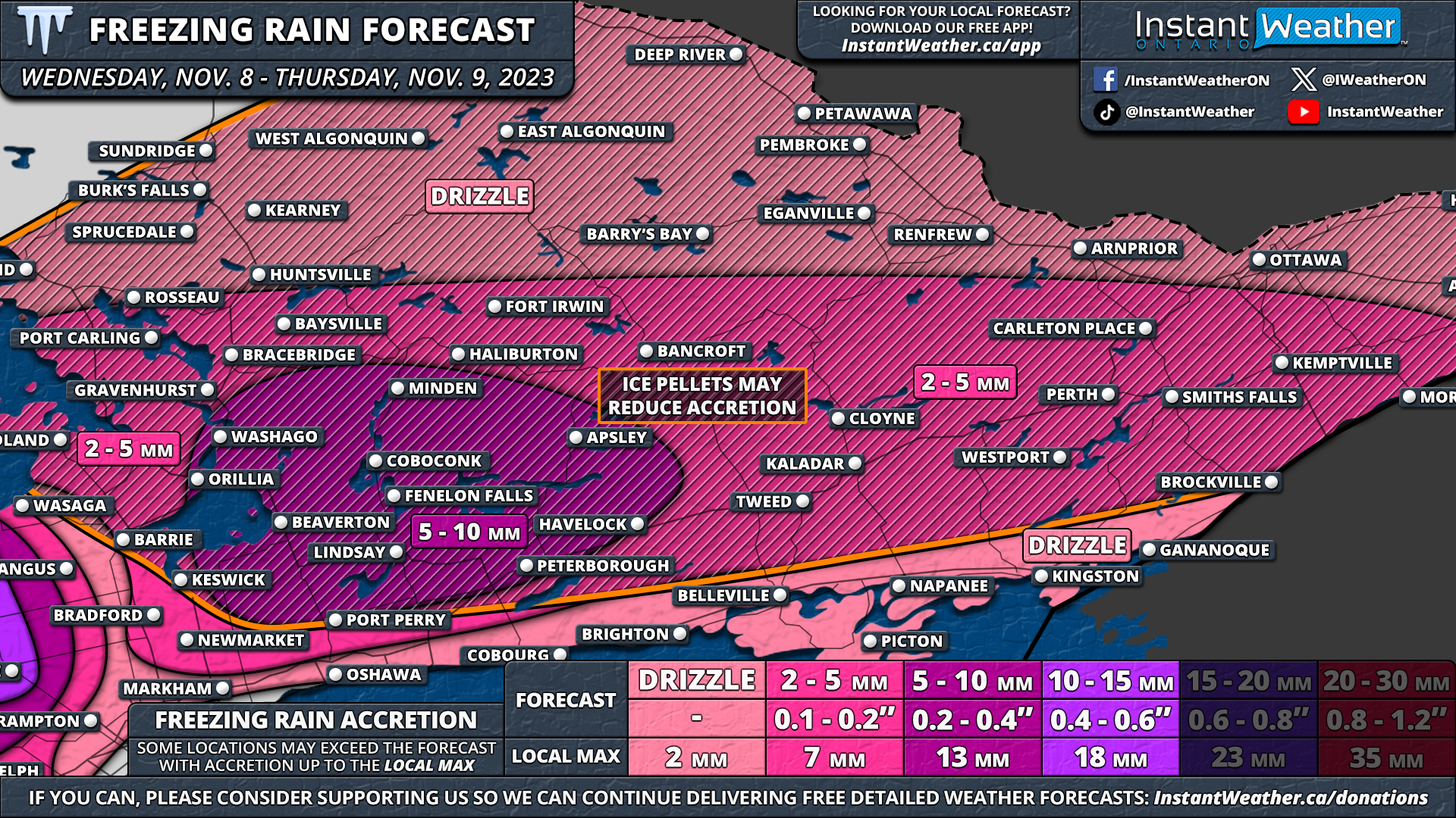
Our forecast for this region has been upgraded to 10-15mm of ice accretion. However, accurately estimating how much of the rain will adhere to surfaces remains challenging, as it could fall rapidly at times.

In the surrounding areas, such as Kitchener, Guelph, Owen Sound, and regions east of Lake Huron, a few hours of freezing rain are expected this afternoon and early evening. It should change to regular rain shortly after dinner. The total ice accretion in these areas will range from 2-5mm, with the potential for up to 5-10mm in higher elevations, including Fergus, Listowel, and Hanover.


GOOGLE AD (NOT ENDORSED BY INSTANT WEATHER)

NOTE: YOU CAN CLICK ON THE MAP TO OPEN A ZOOMABLE IMAGE

As we progress into the overnight hours, our focus will shift to the north and east, with a secondary area of freezing rain set to develop just before midnight across Central and Eastern Ontario. This is likely to continue into Thursday morning, potentially leading to school bus cancellations - further details will be available in our first 'ice day' forecast of the season tonight.

The freezing rain forecast for Central and Eastern Ontario carries some uncertainty due to the presence of ice pellets and snow mixing with freezing rain. The area hardest hit appears to be east of Lake Simcoe, with an expected 5-10mm of ice for Kawartha Lakes and Peterborough.

An extensive zone spanning from Muskoka through the Ottawa Valley should anticipate around 2-5mm of freezing rain. Less freezing rain is expected further north, where snow and ice pellets will take precedence.

It's important to note that the inclusion of ice pellets in Central and Eastern Ontario may lead to reduced ice accretion. This is shown on our map in the orange hatched outline where we expected ice pellets could reduce the ice accretion.

We anticipate that the wintry weather across Southern Ontario will subside by early Thursday afternoon as the system departs the region.


GOOGLE AD (NOT ENDORSED BY INSTANT WEATHER)


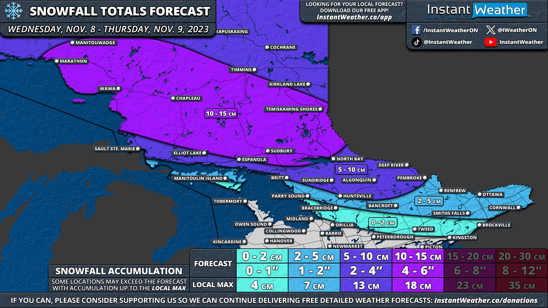
The story further north across Northeastern Ontario will be about the heavy snow starting Wednesday evening. This snow will continue overnight and linger throughout the day on Thursday. We expect that the worst conditions will be felt during the morning hours on Thursday with the heaviest snowfall rates.

As the snow comes to an end by Thursday evening, some parts of Northeastern Ontario could be looking at between 15-20cm of snow on the ground. This includes Chapleau, Timmins, Kirkland Lake and Temiskaming Shores. It isn’t out of the question that some locally higher totals of up to 25cm could occur within this region.

For the rest of Northeastern Ontario, you can expect between 10-15cm of snow along with some ice pellets for locations around Georgian Bay including Sudbury and North Bay. Less than 10cm of snow is expected across Northwestern Ontario so we haven’t included them in this forecast.


GOOGLE AD (NOT ENDORSED BY INSTANT WEATHER)

NOTE: YOU CAN CLICK ON THE MAP TO OPEN A ZOOMABLE IMAGE

The mixing line with this system will likely set up somewhere in the northern section of Central and Eastern Ontario. As a result, the potential for snow extends southwards into parts of Southern Ontario. We are expecting the highest totals through Sundridge and Algonquin Park with between 10 to 15cm of snowfall accumulation.

Around 5 to 10cm of snow is on tap for Huntsville, Bancroft and the Ottawa Valley including the City of Ottawa. Lower amounts are expected further south where freezing rain will be the focus. Between 2-5cm of snow is possible for Bracebridge, Smiths Falls and Cornwall. A few wet flurries are likely across the Golden Horseshoe and around Lake Simcoe this afternoon before it switches over to ice pellets and freezing rain.

Similarly to the freezing rain, ice pellets could also affect the overall snowfall totals. Especially in Central and Eastern Ontario where models disagree on the extent of ice pellets mixing in with the snow. More ice pellets would likely lead to lower snowfall totals in this area.

GOOGLE AD (NOT ENDORSED BY INSTANT WEATHER)

Messy Commute Ahead: Prolonged Freezing Rain Risk in Parts of Southern Ontario Starting Wednesday Afternoon

UPDATED FORECAST:


OLD FORECAST:

NOTE: YOU CAN CLICK ON THE MAP TO OPEN A ZOOMABLE IMAGE

Ontario has seen an early onset of winter weather with multiple snowfalls, yet the first true ‘winter storm’ has been absent—until now. A complex wintery mix looms, set to deliver a blend of freezing rain, ice pellets, and heavy snow to parts of the province beginning Wednesday.

A system from the US Midwest will arrive in Ontario by Wednesday afternoon. As the initial bands of precipitation first reach Southwestern Ontario, the rain will meet a pocket of cold air at ground level, leading to the formation of freezing rain.


GOOGLE AD (NOT ENDORSED BY INSTANT WEATHER)

The higher terrain of Southwestern Ontario, just northwest of the Greater Toronto Area (GTA), could face extended periods of freezing rain, peaking during the evening rush hour.

Locations like Guelph, Kitchener, Hanover, and Orangeville might see freezing rain lasting throughout the late afternoon and early evening.

Areas around Lake Simcoe are also in the bullseye for a mix of freezing rain, ice pellets, and wet snow starting early in the evening.

Overnight, temperatures are predicted to climb, transitioning the freezing rain in Southwestern Ontario to plain rain, while Eastern and Central Ontario will likely see snow and ice pellets.

By Thursday morning, however, the southern portion of Central/Eastern Ontario—stretching from Muskoka through Bancroft to the Ottawa Valley—may experience some freezing rain.


NOTE: YOU CAN CLICK ON THE MAP TO OPEN A ZOOMABLE IMAGE


GOOGLE AD (NOT ENDORSED BY INSTANT WEATHER)

Our forecast splits the difference, with up to 5-10mm of ice accumulation in the Dundalk Highlands and east of Lake Huron, with 2-5mm possible in the northern GTA, around Lake Simcoe, and towards Peterborough.

Light icing is likely across Central and Eastern Ontario with freezing drizzle during Thursday's early hours. Remember, ice accumulation will depend on the precise temperatures and how swiftly they rise past freezing. Given the short duration, the impact should be more limited.

Yet, even this amount of ice can cause treacherous roads and power outages, not to mention the potential for school bus cancellations, especially in Central and Eastern Ontario, where conditions will remain challenging into Thursday morning.


NOTE: YOU CAN CLICK ON THE MAP TO OPEN A ZOOMABLE IMAGE


GOOGLE AD (NOT ENDORSED BY INSTANT WEATHER)

Northeastern Ontario is set to see primarily snowfall, with ice pellets likely near Sudbury and North Bay. Snowfall begins late Wednesday and continues into early Thursday, with the heaviest snow expected overnight at rates of 2-3cm per hour.

Initial data showed Northeastern Ontario could receive up to 30cm of snow, but recent updates suggest a more manageable 10-15cm for Sudbury, Chapleau, and Temiskaming Shores. Elsewhere in Northern Ontario, from Thunder Bay to the Manitoba border, 5-10cm is forecasted.

Moving south into Central and Eastern Ontario, less snow is anticipated. Algonquin Park and northern Central Ontario may still see a notable accumulation of 5-10cm with ice pellets, while less than 5cm is expected for the remainder of these regions.

Rain is on the menu for Windsor, Chatham, Sarnia, London, and the Golden Horseshoe, which will sidestep the winter conditions. Come Thursday, they can expect 10-20mm of rain, with potential for higher localized totals.

GOOGLE AD (NOT ENDORSED BY INSTANT WEATHER)

Could Ontario’s First Winter Storm of the Season Be on the Horizon Late Wednesday?


Heads up! We’re tracking the potential for messy winter weather from late Wednesday into Thursday. A low-pressure system is expected to traverse the Great Lakes mid-next week, bringing a blend of snow, freezing rain, and ice pellets to the north, with heavy rain expected in the south.

The exact position of the mix line hinges on the system's path, which remains slightly uncertain. Current models suggest it will pass over Lake Huron and Georgian Bay, likely bringing heavy snow to Northeastern Ontario and a freezing rain threat to Central and Eastern regions.


GOOGLE AD (NOT ENDORSED BY INSTANT WEATHER)

In Northeastern Ontario, accumulations could reach 20-30 cm in areas like Timmins and Kapuskasing. To the south, several hours of freezing rain may affect North Bay, Muskoka, Algonquin Park, Bancroft, and the Ottawa Valley.

The most severe conditions are anticipated overnight Wednesday, potentially disrupting Thursday morning's commute, including possible school bus cancellations.

While those in Southwestern Ontario and the Golden Horseshoe are currently expecting mostly rain from this system, it could change as we get closer to Wednesday.

Check back for a more detailed forecast in the coming days.


GOOGLE AD (NOT ENDORSED BY INSTANT WEATHER)

Snow Squalls Could Bring a Frightening 15-25cm of Snow to Parts of Southern Ontario on Halloween Night

NOTE: YOU CAN CLICK ON THE MAP TO OPEN A ZOOMABLE IMAGE

Many across Southern Ontario received a chilling surprise this morning: a blanket of snow. Notably, areas around Lake Huron and Georgian Bay saw accumulations thanks to the active lake effect snow from the past 24 hours.

However, Mother Nature isn’t done playing her snowy tricks, as snow squalls are predicted to make a comeback later today. In fact, lake-effect snow off Georgian Bay is already affecting the Parry Sound region this afternoon.

These snow bands will persist into the evening off Georgian Bay, but a wind shift around midnight will divert this lake effect activity southward. This means a brief but intense bout of snowfall for Muskoka and Simcoe County between 10 PM and 1 AM.

If you're travelling in this area tonight, exercise caution: these squalls can dramatically reduce visibility within seconds!


GOOGLE AD (NOT ENDORSED BY INSTANT WEATHER)

Another round of lake effect snow from Lake Huron may result in heavy snowfall from Goderich through Kincardine to the Owen Sound region, primarily in the evening and early hours, shifting south after midnight.

As the night progresses, the snow activity off Georgian Bay appears to weaken, leaving some lingering flurries near Meaford and Collingwood. On the other hand, the squalls from Lake Huron may intensify before dawn on Wednesday.

Current data suggests this main band will target the southeastern shoreline of Lake Huron, especially from east of Sarnia through Lambton Shores to Grand Bend. This region may bear the brunt of the lake effect activity from late night to Wednesday morning.


NOTE: YOU CAN CLICK ON THE MAP TO OPEN A ZOOMABLE IMAGE


GOOGLE AD (NOT ENDORSED BY INSTANT WEATHER)

There is some uncertainty about the exact location and intensity of the lake-effect snow. It could potentially be strong leading to heavy snowfall rates lasting several hours between Sarnia and Grand Bend. Wednesday morning might pose challenging driving conditions, with a possibility of localized school bus cancellations.

By Wednesday noon, the organized lake effect snow should dissipate. Some residual flurries east of Lake Huron might linger, but no significant accumulation is anticipated.

As typical with lake effect events, the heaviest snowfall will be localized. Current model data shows a pocket between Sarnia and Lambton Shores could see up to 25cm by Wednesday afternoon.

We're forecasting 15-25cm, but it’s crucial to understand the unpredictable nature of lake-effect snow. We’re confident someone in this zone will approach 25cm, depending on the squall’s precise path. But not everyone will see that much snow and even some may see only a few centimetres as the squall will be very narrow.


GOOGLE AD (NOT ENDORSED BY INSTANT WEATHER)

For areas northeast of Georgian Bay, up to 10-20cm is expected around Parry Sound and Sundridge, mostly falling this afternoon and evening. Surrounding regions east of Lake Huron and south of Georgian Bay might see 6-12cm, depending on the location of the lake effect activity

Central Ontario regions like Muskoka and Simcoe County could receive about 4-8cm, primarily over the period of a few hours late tonight as the squalls move south.

For the rest of Southern Ontario, significant accumulation is unlikely. However, some scattered lake effect flurries tonight and early tomorrow are possible, but it won't be widespread and more likely the closer you are to Lake Huron or Georgian Bay.

GOOGLE AD (NOT ENDORSED BY INSTANT WEATHER)

Mother Nature Casts a Chilling Spell Over Ontario With Spooky Temperatures & Snow on Halloween

NOTE: YOU CAN CLICK ON THE MAP TO OPEN A ZOOMABLE IMAGE

Can you feel the eerie chill in the air? It's not just because Halloween is a mere 24 hours away. The wicked witch that is Mother Nature is casting a chilling spell over Ontario, wrapping us in cold temperatures and ghostly snow.

Come Halloween morning, some regions might find so much snow that it'll take more than a mere broomstick to clear those tombstones. Lake effect snow around Lake Superior, Huron, and Georgian Bay might pile up a ghastly 5-15cm by daybreak. The Sault Ste Marie area might even see a haunting 25cm!


As noon approaches, the snow will retreat into the shadows. Expect temperatures to peak in the low single digits in Southern Ontario and plunge a few degrees below freezing in the North.

But don't be fooled! The lake effect snow bands will rise again, zombie-like, by late afternoon, driven by a southwesterly flow. This could ensnare the Grey-Bruce and Parry Sound regions in heavy wet snow and blinding conditions by dusk.


GOOGLE AD (NOT ENDORSED BY INSTANT WEATHER)

Late in the evening, the winds will change course, pushing snow bands from Lake Huron and Georgian Bay southwards. There might be a sudden, frightful burst of snow between 9 PM - 2 AM in Simcoe County, Exeter, and the Grand Bend area.

Some accumulation is possible overnight into Wednesday in Grand Bend, Meaford, and Collingwood. We'll have more on that in an upcoming forecast!


NOTE: YOU CAN CLICK ON THE MAP TO OPEN A ZOOMABLE IMAGE


GOOGLE AD (NOT ENDORSED BY INSTANT WEATHER)

If any ghosts and goblins are venturing out for treats, they'll face bone-chilling temperatures across Ontario.

Early evening temperatures will range from -5°C in the northwest to 5°C around Lake Erie and the Niagara region. In Southwestern Ontario and the GTA, temperatures will hover just above freezing.

It'll be equally bone-chilling further north in Central and Eastern Ontario, with temperatures near freezing. Higher elevations in Central Ontario and throughout Northern Ontario will see below-freezing temperatures.


GOOGLE AD (NOT ENDORSED BY INSTANT WEATHER)

Northwestern Ontario might even experience -5°C, the night's coldest spot.

From the Instant Weather team, we wish you a thrilling (yet safe) Halloween! Bundle up and keep cozy!

GOOGLE AD (NOT ENDORSED BY INSTANT WEATHER)

Spooky Snow Set to Haunt Ontario With Up to 15-25cm Possible by Tuesday

NOTE: YOU CAN CLICK ON THE MAP TO OPEN A ZOOMABLE IMAGE

October in Ontario has been a mix of tricks and treats. While we've basked in some unseasonably warm "treats" this month, including record-breaking highs last week, it seems Mother Nature might have a little "trick" up her sleeve just in time for Halloween.

This unexpected surprise will unfurl as widespread snowfall, starting early Monday and stretching into Tuesday, with some lake-effect snow hauntings around Georgian Bay, Lake Huron, and Lake Superior. By the time trick-or-treaters venture out on Halloween evening, some parts of Ontario might be walking through a 15-25cm blanket of ghostly white snow!


GOOGLE AD (NOT ENDORSED BY INSTANT WEATHER)

Ontario's current chilling touch is a prelude to what lies ahead. A system is breezing through Southern Ontario, mainly shedding tears of rain, but there've been whispers of sleet in some corners. Temperatures are expected to take a ghostly dip overnight, nearing the freezing mark in Central and Eastern Ontario.

With rain continuing into Monday, expect some of it to transform into wet snow by dawn. Early risers in Eastern Ontario, especially the Ottawa Valley, might find a sprinkling of this icy confetti. However, with temperatures close to freezing, this early snowfall might melt as quickly as a vampire in sunlight. But regions like Bancroft and Barry’s Bay might see a more noticeable 4-6cm of snow.


NOTE: YOU CAN CLICK ON THE MAP TO OPEN A ZOOMABLE IMAGE


GOOGLE AD (NOT ENDORSED BY INSTANT WEATHER)

As colder air follows this system, lake-effect snow will intensify, starting with Lake Superior on Monday. Snow squalls will push heavy snow into the Sault Ste. Marie region from Lake Superior. Other lake effect snow bands will impact areas east of Lake Superior, like Wawa and Marathon, though less intensely. This activity will persist until Tuesday afternoon.

Further south, Lake Huron and Georgian Bay will join the Halloween mischief by Monday evening. The main snow band could stretch from the Bruce Peninsula to between Barrie and Orillia, though its exact path remains uncertain.

By Monday's witching hour, Central Ontario's temperatures will dip below freezing, giving the lake effect snow a boost. Early Tuesday might even feature thundersnow, so don’t be too spooked if early Tuesday brings a rare thundersnow event!

On Halloween morning, you might have to brush off a light layer of snow from your jack-o'-lanterns. The sun should help melt some of it, but lake-effect snow might make a brief comeback just as the evening's ghoulish festivities begin. The Parry Sound region seems to be the favoured haunt for this snow activity. A clearer forecast for Tuesday evening and Wednesday will be conjured up closer to the event.

The projected snowfall accumulation may cause you to let out a blood-curdling scream in some areas. The Sault Ste. Marie area, in particular, could receive 15-25cm of snow, or possibly more if the snow remains intense. Areas east of Lake Superior might get around 6-12cm.


GOOGLE AD (NOT ENDORSED BY INSTANT WEATHER)

Accumulation in Southern Ontario is uncertain due to temperatures near freezing. The Bruce Peninsula and Simcoe County might see 6-12cm, with localized areas possibly reaching 15-20cm if conditions are right.

Other parts of Southern Ontario might get a sprinkle of wet snow, but significant accumulation is unlikely. Deep Southwestern areas, like Sarnia, Windsor, and the Niagara region, probably won't see any snow in the coming days.

GOOGLE AD (NOT ENDORSED BY INSTANT WEATHER)

Do You Want to Build a Snow Turkey? Parts of Ontario to See Up to 10-20cm of Snow for Thanksgiving

NOTE: YOU CAN CLICK ON THE MAP TO OPEN A ZOOMABLE IMAGE

October has started on a wild note in Ontario this year. After experiencing record-breaking temperatures soaring past 30°C earlier in the week, we're now shifting gears. The recent days have showcased more traditional fall weather with rain and chilly evenings. Yet, as the forecast suggests, it seems Mother Nature might be pulling a spooky Halloween prank on our region a bit early.

Indeed, the forecast hints at the season's first snowfall covering a vast portion of Northeastern Ontario and extending to the northern regions of Southern Ontario. By Tuesday, some areas could see snow accumulations reaching 10-20cm.


GOOGLE AD (NOT ENDORSED BY INSTANT WEATHER)

GOOGLE AD (NOT ENDORSED BY INSTANT WEATHER)

As the temperatures gradually dip overnight heading into Sunday morning, anticipated rainfall is expected to transition into wet snow in areas such as Timmins, Cochrane, and Chapleau in Northeastern Ontario. The snow will slowly draw south, enveloping Sudbury, North Bay, and parts of Central Ontario. Considering the ground's retained warmth, most snowfall is likely to melt upon impact.

The snow is set to persist from Sunday night into Monday for Northeastern and Central Ontario. With temperatures possibly plummeting a few degrees below freezing in certain areas, we may start to see the snow accumulating on the ground by Monday morning.

During late Sunday and early Monday, the snow could be heavy at times, leading to slush-covered roads and diminished visibility. It's essential for drivers to be cautious, especially since many might not have transitioned to winter tires yet. Monday will continue the potential for scattered flurries, eventually turning into rain showers as temperatures climb. Although the snow might still be present in Northeastern Ontario by Monday night, it should dissipate by Tuesday morning.


NOTE: YOU CAN CLICK ON THE MAP TO OPEN A ZOOMABLE IMAGE


GOOGLE AD (NOT ENDORSED BY INSTANT WEATHER)

GOOGLE AD (NOT ENDORSED BY INSTANT WEATHER)

Predicting the exact accumulation is challenging. While models are good at estimating the amount of precipitation that will come from the sky, the ground's warmth and hovering freezing temperatures could result in much of the snow melting on contact.

Raw model data indicates that areas just north of Sudbury, like Timmins and Englehart, could experience the most snow. Here, upwards of 30cm might fall from the sky, but considering the factors mentioned earlier, the actual ground accumulation should end up between 10-20cm. These numbers are a rough idea and depend on various local dynamics.

The next few days carry the potential for both under and overperformance due to the expected amount of precipitation. Maximum accumulation is likely during Sunday night or early Monday. As Monday warms up, any snow gathered on the ground will quickly melt.

The rest of Northeastern Ontario away from the shoreline of Lake Superior and Georgian Bay including Sudbury, Elliot Lake, Chapleau and Cochrane can expect some minor accumulation ranging from 4 to 10cm by early Monday morning.

For Southern Ontario, Central Ontario might also experience the season's first few snowflakes, with accumulations possibly reaching 2-6cm in areas like Algonquin Park, Sundridge, and Huntsville. The rest of Central Ontario including Parry Sound, Bracebridge, Haliburton, Bancroft, Pembroke and Renfrew can expect a few flakes, but no substantial accumulation is anticipated.


NOTE: YOU CAN CLICK ON THE MAP TO OPEN A ZOOMABLE IMAGE


GOOGLE AD (NOT ENDORSED BY INSTANT WEATHER)

GOOGLE AD (NOT ENDORSED BY INSTANT WEATHER)

The imminent cold combined with the Great Lakes' warmth will bring the return of lake-effect precipitation in the coming days. Most of Southern Ontario will be spared from snow, but regions around Lake Huron and Georgian Bay could see rainfall totals of between 25-50mm by Monday's end, with some areas potentially receiving up to 75mm.

Elsewhere in Southern Ontario, intermittent showers are predicted, with the heaviest rainfall in Southwestern and Eastern Ontario. Regions in deep Southwestern Ontario and along the Golden Horseshoe might experience minimal rain, with less than 10mm of accumulation expected.

Thunderstorm Risk Shifts East on Thursday With Severe Storms Possible in Central Ontario & Ottawa Valley

NOTE: YOU CAN CLICK ON THE MAP TO OPEN A ZOOMABLE IMAGE WHICH WILL BE EASIER TO READ.


The recent intense heatwave in Southern Ontario is coming to an end, but not without some thunderstorm activity. This has caused a noticeable cooldown in Southwestern Ontario and around the Golden Horseshoe. As a result, Environment Canada has lifted the heat warning for many regions in Southern Ontario. However, part of Eastern Ontario is still experiencing hot weather and the warning remains in place for them for one more day.

Similar to yesterday, relief from the warm temperatures will come in the form of isolated pop-up thunderstorms throughout the afternoon and early evening hours. The focus of this activity will be from just north of the GTA through Lake Simcoe and up into Central Ontario. Later in the day, the Ottawa Valley could also see some storm activity.

While these storms are expected to remain non-severe for the most part, the environment is favourable for a few isolated storms to reach severe levels. The main risks include 90 km/h wind gusts and hail up to the size of quarters. An isolated tornado can’t be ruled out, but the risk is fairly low. If there is a tornado risk, it will likely be highest around the Lake Simcoe and Bancroft area.

The storm risk is expected to come to an end by later this evening. In the wake of the storms, we will see much cooler air flow in overnight with parts of Central Ontario potentially touching the upper single digits by Friday morning. This will set the stage for a much cooler weekend with weather more usual for this time of the year.

Severe Thunderstorm Risk Returns to Southern Ontario on Wednesday and Thursday

NOTE: YOU CAN CLICK ON THE MAP TO OPEN A ZOOMABLE IMAGE WHICH WILL BE EASIER TO READ.


The first full week of September has begun with unusually warm temperatures, bringing some of the hottest weather we've experienced all summer in Southern Ontario. This hot and humid air is a crucial ingredient in thunderstorms, and it will certainly play a significant role over the next two days, with the risk of severe storms returning to our region later this afternoon and again on Thursday.

As of early Wednesday afternoon, we are currently seeing the development of storms over Michigan, which are tracking into Southwestern Ontario. These storms will continue tracking to the northeast, with more pop-up activity anticipated around Georgian Bay by late afternoon. The daylight heating that fuels these storms will begin to wane in the early evening once the sun sets, leading to a gradual weakening in the storm activity around 8 or 9 PM.

For the most part, these storms should remain non-severe; however, we can't rule out the possibility of a few isolated severe storms. The primary concern will be damaging wind gusts exceeding 90 km/h, and there is also a chance of small hail up to the size of dimes along with heavy rainfall. While the tornado risk for all of Southern Ontario is relatively low, we can never entirely dismiss the possibility of an isolated tornado if the right conditions come together.


It's crucial to note that while we have an expansive isolated severe risk, not all areas within the forecast will experience severe weather. The environment is conducive to severe storms, but pinpointing exactly where these storms will occur remains challenging.

Similar dynamics will be in play on Thursday afternoon and evening. The focus of tomorrow's risk will be in Central and Eastern Ontario, although the development of storms is less certain. The storm mode is expected to be more discrete, increasing the potential for hail and tornadoes compared to today.

There are still many uncertainties, so we are awaiting more data before putting together a forecast for the storms on Thursday. Stay tuned for a detailed forecast, which we will provide either later today or early tomorrow.

ONTARIO: Thunderstorm Forecast for Saturday, September 2, 2023

NOTE: YOU CAN CLICK ON THE MAP TO OPEN A ZOOMABLE IMAGE WHICH WILL BE EASIER TO READ.


Thunderstorms are currently not expected across Southern Ontario on Saturday.

NORTHERN ONTARIO: Thunderstorm Forecast for Saturday, September 2, 2023

NOTE: YOU CAN CLICK ON THE MAP TO OPEN A ZOOMABLE IMAGE WHICH WILL BE EASIER TO READ.


Thunderstorms are currently not expected across Northern Ontario on Saturday.

ONTARIO: Thunderstorm Forecast for Friday, September 1, 2023

NOTE: YOU CAN CLICK ON THE MAP TO OPEN A ZOOMABLE IMAGE WHICH WILL BE EASIER TO READ.


Thunderstorms are currently not expected across Southern Ontario on Friday.

NORTHERN ONTARIO: Thunderstorm Forecast for Friday, September 1, 2023

NOTE: YOU CAN CLICK ON THE MAP TO OPEN A ZOOMABLE IMAGE WHICH WILL BE EASIER TO READ.


Thunderstorms are currently not expected across Northern Ontario on Friday.

Rare August Frost Risk for Parts of Southern Ontario on Wednesday Night

NOTE: YOU CAN CLICK ON THE MAP TO OPEN A ZOOMABLE IMAGE WHICH WILL BE EASIER TO READ.


As August gives way to September, there is usually a noticeable fall-like feeling in the air, marked by the gradual transition from warm, humid summer temperatures to crisp autumn temperatures. This seasonal shift generally unfolds over weeks, with overnight lows gradually settling into the mid to upper single digits. Eventually, the risk of frost sneaks into the conversation, typically by late September or early October, depending on the region.

This year, however, Mother Nature seems inclined to speed up this transition with a preview of fall weather for Southern Ontario over the next few days. Currently, daytime highs for Wednesday are hovering in the low to mid double digits for much of the region leading to a chilly feeling in the air.

This is just the beginning of the 'August Freeze.' We are expecting a chilly start to the day on Thursday, with overnight temperature lows plummeting to 5-10°C across much of Southern Ontario. The colder air will encompass much of Southern Ontario with the warmest temperatures being found in Deep Southwestern Ontario and around Lake Ontario.

On the other hand, in some higher elevation areas of Central Ontario, like Muskoka, Haliburton, and Algonquin Park, the temperature might drop to near the freezing mark. Because of this and clear skies, there could be the risk of frost during the overnight hours extending into the early morning of Thursday. This is unusual for this time of year, as Algonquin Park usually experiences its first frost on September 22nd.


As a result, Environment Canada has issued a frost advisory for the following locations:

  • Baysville

  • Burk's Falls

  • Deep River

  • Eastern Algonquin Park

  • Fort Irwin

  • Huntsville

  • Lake of Two Rivers

  • Northern Haliburton County

  • Oxtongue Lake

  • South River

  • Western Algonquin Park

  • Whitney

Environment Canada mentions the potential for frost to develop late tonight and continuing into the pre-dawn hours of Thursday:

For the summer lovers, don’t worry as this taste of autumn will be brief. We will see the return of more seasonal temperatures by the weekend. The start of a new week and September's first full week could feature daytime highs soaring well into the 30s for some areas. There will also be the risk of thunderstorm activity!

ONTARIO: Thunderstorm Forecast for Thursday, August 31, 2023

NOTE: YOU CAN CLICK ON THE MAP TO OPEN A ZOOMABLE IMAGE WHICH WILL BE EASIER TO READ.


Thunderstorms are currently not expected across Southern Ontario on Thursday.

NORTHERN ONTARIO: Thunderstorm Forecast for Thursday, August 31, 2023

NOTE: YOU CAN CLICK ON THE MAP TO OPEN A ZOOMABLE IMAGE WHICH WILL BE EASIER TO READ.


Thunderstorms are currently not expected across Northern Ontario on Thursday.

ONTARIO: Thunderstorm Forecast for Wednesday, August 30, 2023

NOTE: YOU CAN CLICK ON THE MAP TO OPEN A ZOOMABLE IMAGE WHICH WILL BE EASIER TO READ.


Thunderstorms are currently not expected across Southern Ontario on Wednesday.

NORTHERN ONTARIO: Thunderstorm Forecast for Wednesday, August 30, 2023

NOTE: YOU CAN CLICK ON THE MAP TO OPEN A ZOOMABLE IMAGE WHICH WILL BE EASIER TO READ.


Thunderstorms are currently not expected across Northern Ontario on Wednesday.