
THIS FORECAST IS EXPIRED
CLICK HERE FOR THE LATEST OUTLOOKS
Ice Storm Starting Saturday (Jan. 11) to Have a Potentially Catastrophic Impact on Parts of Southern Ontario
Published: Friday, January 10, 2020 - 7:30PM
By Brennen Perry
Mobile Tip: You can zoom into the map by clicking on it. The map will open in a new tab that is easily zoomable.
We continue to closely monitor what is shaping up to be a potentially historic winter storm for Southern Ontario starting Saturday and lasting into Sunday. A moisture-laden system will tap into moisture from the Gulf of Mexico and act as a ‘conveyor belt’ pumping it right into our region over the weekend resulting in excessive amounts of precipitation ranging from rain, snow, ice pellets and even more concerning, freezing rain. Extensive damage to the power grid could be potentially catastrophic in some areas with over an inch of ice accretion along with strong wind gusts which means we could see outages that last days. It’s also looking possible that temperatures might not get above the freezing mark after the freezing rain so the ice accretion could stick around into early next week leading to long-lasting impact.
When you wake up on Saturday it might seem like this storm isn’t as bad as is being forecasted with mild temperatures well above the freezing mark and rainfall, but don’t let that fool you! Temperatures will drop rapidly throughout the day on Saturday resulting in a transition over to wintry precipitation beginning with freezing rain and moving over to ice pellets or snow further north. Some areas, particularly just north of the GTA, eastward through Peterborough and into Brockville could easily see 16-24 hours of constant heavy freezing rain. The freezing rain will begin just after the lunch hour on Saturday and last through the day and into Sunday morning so conditions will be at the worst late Saturday and during the overnight hours. Strong wind gusts will also develop early Sunday after all the icing gusting up to 50-80km/h during the morning and afternoon which would further complicate the situation and likely result in many power outages. We will focus more on the wind gusts with a seperate forecast to be posted Saturday once we get an idea on the exact strength of the wind risk.
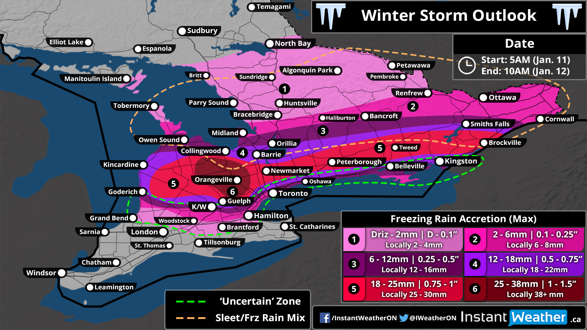
There’s a lot to talk about with this upcoming storm as the actual impact will be vastly different across the province. We’re going to start with the potential ice storm, but the flooding risk is certainly not to be ignored so continue reading below for details on that. As mentioned, some rain will start the day for many on Saturday although we’ll begin to see a line of freezing rain develop from Britt to North Bay around 5 am as cold air begins to cause temperatures at the surface to drop below the freezing mark. This thin line of freezing rain will begin to expand as it moves southward - areas roughly north of a line from Bracebridge to Renfrew will see a few hours of freezing rain in the morning or early afternoon hours before switching over to an ice pellet and heavy snow mix. By Saturday late afternoon, we’ll see a fairly expansive area of heavy freezing rain develop from Goderich through Orangeville, Northern GTA and into Ottawa. Areas to the north from Owen Sound to Bancroft will see mostly ice pellets while those closer to the Lake Ontario shoreline will hold onto the rain for a few more hours with slightly warmer temperatures.
The tricky part of this forecast where lots of uncertainty remains is an area through K/W, the GTA and along the Lake Ontario shoreline out into Eastern Ontario as we’re not quite sure how quickly temperatures will fall below the freezing mark if at all. We’ve highlighted this ‘uncertain’ area with the green dashed line on our map above. If the cold air makes it that far south and causes temperatures to get below zero by Saturday evening it would be a very dangerous situation with heavy freezing rain continuing overnight and into Sunday morning. On the other hand, if temperatures can stay even just a fraction above zero past midnight resulting in more rain then it will greatly reduce the ice storm threat for that area. The bottom line is that you should be prepared for a very impactful ice storm including through the GTA but don’t be surprised to see this storm be a big ‘bust’ in those areas. We’ve gone on the lower side for the City of Toronto with 2-6mm of ice accretion close to the lakeshore and 6-12mm in the north end of the city although it’s conceivable to see much higher totals should the colder scenario play out.
As shown on our map above, we expect the worst conditions through the Dundalk Highlands including Orangeville and Shelburne where total ice accretion could range from 25-38mm. The potential for this event to overperform is also there with some models showing total freezing rain precipitation (don’t mean it’ll stick to surfaces) exceeding 50mm, but give the intensity of the rainfall we believe all of it will have a hard time to stick on surfaces hence the lower ice accretion projections. A fairly large region including locations like Hanover, Newmarket, Peterborough and Brockville is on track to see between 18-25mm of ice accretion with locally higher amounts. Extending outward from that, the expected accretion will drop off quite fast with ice pellets mixing into the north and more rain to the south closer to the Lake Ontario shoreline. Note that regions within the orange dotted line on our map could see a lot less freezing rain than forecasted should ice pellets be more prevalent. Some minor ice accretion is expected through more northern parts of Central and Eastern Ontario although ice pellets and snow will be the main precipitation type.
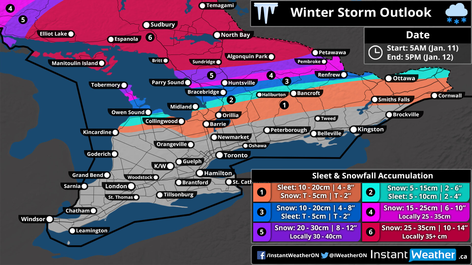
Turning our attention to the more northern part of our region, heavy accumulating snow and an excessive amount of ice pellets are expected from this storm. Snow will start for Northeastern Ontario including Sudbury and North Bay during the early morning hours on Saturday with the mixing line progressing to the south throughout the morning. Light to moderate snow will continue for this area through the afternoon although might taper off for a few hours during the early evening before a second round of heavier snowfall moves into the region just past the midnight hour. The heaviest accumulation by Sunday afternoon is expected north of a line from Britt to Petawawa with up to 25-35cm and locally higher amounts potentially exceeding 35cm.
The gradient between little to significant snowfall is extremely tight because more ice pellets will mix in to the south and reduce the potential accumulation quite quickly. As such, locations including Parry Sound and Pembroke will see between 20-30cm of snowfall with some freezing rain and ice pellets. The Muskoka region and into Renfrew can expect between 10-20cm of snowfall and up to 5cm of ice pellets. A zone stretching from Barrie through Bancroft and Ottawa will see mainly ice pellets with as much as 20cm of ice pellets with limited snowfall accumulation (note: freezing rain is also possible in this area as well). This amount of ice pellets is quite significant and could lead to a significant impact on travel throughout the region. Keep in mind that ice pellets are much denser than snow so it will be harder to clear and could pose a health hazard to those trying to shovel it away compared to 20cm of regular snow.
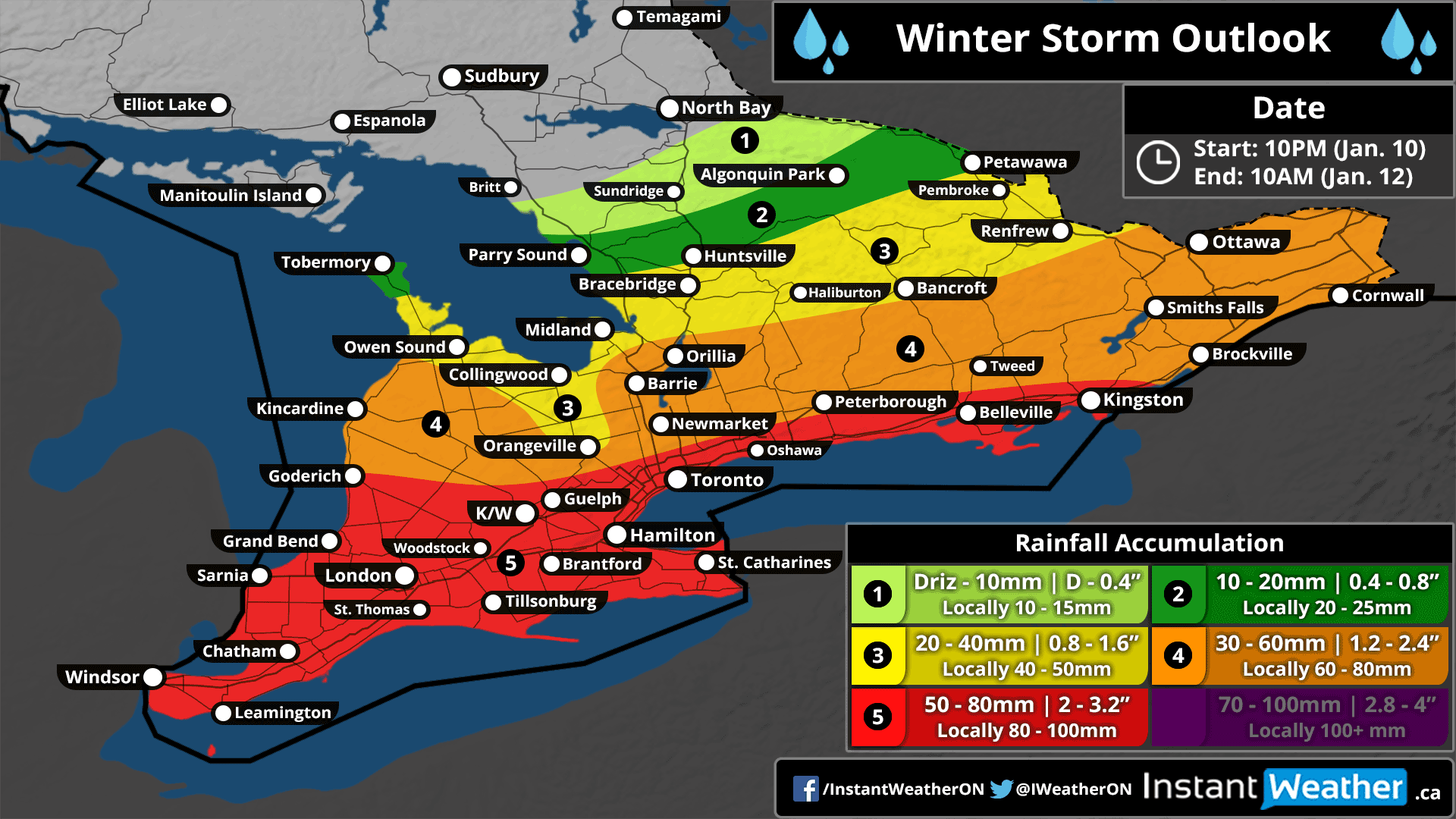
The other big risk from this storm is the excessive amount of precipitation it will dump across Southern Ontario regardless of how it comes down. At least 20cmm of rain is expected in almost all of Southern Ontario even in areas that will see mostly wintery precipitation from this storm as rain is expected to start several hours during the morning on Saturday before it transitions over to anything else. The situation is even worse further south through Southwestern Ontario and along the Lake Ontario and Erie shoreline with rainfall amounts ranging from 50-80mm with locally up to 100mm. The rain has already started near Lake Erie and will continue to work its way into the region throughout the night and morning hours with it continuing all day Saturday. The heaviest rainfall is expected late Saturday and overnight with relentless downpours lasting for hours. We expect it’ll begin to taper Sunday morning and fully end by noon.
Flooding is a major concern across the province as we don’t typically see this much rain from one storm let alone in the middle of the winter when the ground is frozen and has limited ability to absorb any excess precipitation. In fact, we could easily see an entire month's worth of rain in just a matter of 24 hours. If you live in a low lying area or around Lake Erie/Ontario that is prone to flooding you should prepare for significant flooding from this storm. Many flood watches and warnings have already been issued by local conservation authorities across the province and can be found here: www.gisapplication.lrc.gov.on.ca/webapps/flood/
You should already be in the process of preparing for this storm, but if you haven't started we’ve put together some helpful tips on how you can stay safe during this storm here. Should you need to go out and grab anything tomorrow to prepare for the storm you should consider doing it in the morning when temperatures are still above freezing. All non-essential travel should be avoided beginning Saturday afternoon for areas that are seeing the wintery precipitation and don’t expect to be able to go anywhere until Sunday afternoon at the earliest. It’s possible that travel might be impossible for several days throughout the hardest-hit regions although that shouldn’t be a widespread issue. Safety first!
Your business could be here!
If you're interested in connecting your organization with our amazing community by sponsoring our forecasts, please visit: instantweatherinc.com/sponsor
