
WARNING: THIS FORECAST IS NO LONGER VALID
CLICK HERE FOR THE LATEST OUTLOOKS
Winter Storm to Impact Ontario With Heavy Snow, Freezing Rain and Damaging Wind Gusts on Sunday
Published: Saturday, November 30, 2019 - 8:20PM
By Brennen Perry
Mobile Tip: You can zoom into the map by click on it. The map will open in a new tap that is easily zoomable.
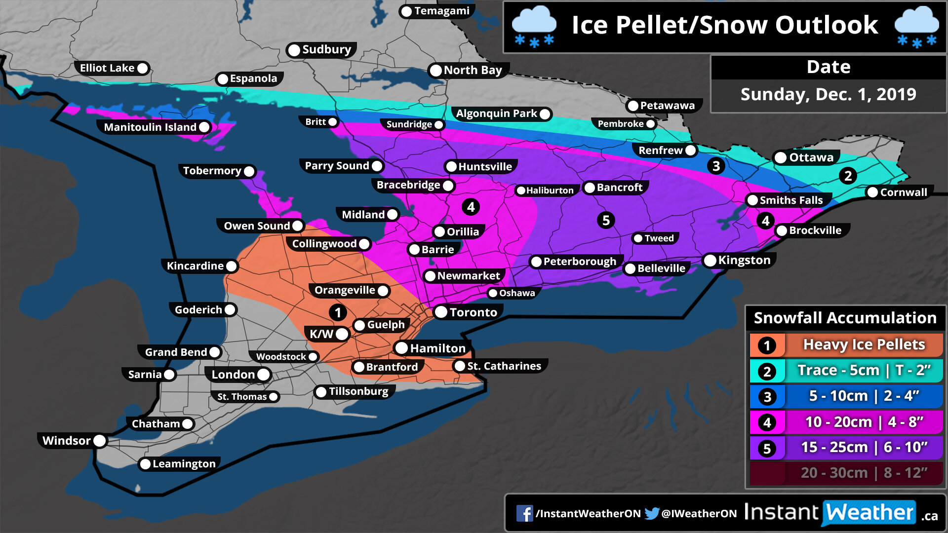
A significant winter storm is setting its sight on Southern Ontario for Sunday with heavy snow, ice pellets and freezing rain all on the table depending on your location. Wind gusts in excess of 80-90km/h in many areas will help create dangerous conditions with blowing snow and power outage potential due to the excessive ice accretion from freezing rain. Precipitation will start around 4-6am for Southwestern Ontario spreading to the northeast throughout the morning and reaching Central and Eastern Ontario by the afternoon. While the majority of the event will occur during the day on Sunday, some snow and freezing drizzle may linger into Monday morning.
The cold side of the system will encompass much of Central and Eastern Ontario extending southward towards the northern shoreline of Lake Ontario. The predominant precipitation throughout this area will be heavy snowfall starting around noon on Sunday and continuing past the midnight hour. The worst conditions will be felt during the late afternoon and evening where intense snowfall rates between 3-6cm per hour will combine with 60+km/h wind guests causing near-zero visibility out on the roads. Right now, we expect widespread 10-20cm in snowfall accumulation with as much as 25cm in the zone extending from Muskoka and southeastward towards the northern Lake Ontario shoreline (Belleville, Kingston etc.).
There is some uncertainty exactly how far to the southwest we’ll see the snowfall as more ice pellets and freezing rain will mix in. This means there’s a chance we could be off in areas around Lake Simcoe and especially in the GTA where a slight difference in the temperature could mean the difference between 5cm and 20cm. We’ve included parts of the GTA in the 10-20cm zone, but it could be less if more ice pellets mix in and there’s even an outside chance that we see over 20cm based on some of the latest model runs. We’ll continue to monitor that and make adjustments to the forecast later tonight if required.


Turning towards what looks like a fairly significant freezing rain event for Southwestern Ontario and in particular, the London and Sarnia region. Freezing rain will begin around 5-7am starting with those closest to Lake Erie and spreading northward later in the morning. Current indications suggest that the freezing rain will be relentless heading into the afternoon and even into the early evening. Some areas could see 8-14 hours of non-stop moderate to heavy freezing rain likely resulting in some substantial ice accretion on tree branches and power lines along with untreated roads.
The hardest hit areas could see as much as 12-18mm of ice accretion, including Sarnia, Grand Bend and London. Although note this is the max ice accretion and it could be less depending on various factors that’s hard to account for. Especially with strong winds which can be a blessing and a curse by blowing rain off of surfaces before it can freeze, but can bring down weakened tree branches onto power lines. The potential accretion will drop as you head to the south due to warmer temperatures throughout Windsor and Chatham leading to mostly rain and to the north as more ice pellets mix in.

This storm will also bring potentially damaging wind gusts to areas around Lake Huron where latest models suggest could see wind gusts in excess of 100km/h during the morning hours on Sunday. The potential for strong wind gusts will exist for most areas throughout Southwestern and Central Ontario along with the GTA with 70+km/h wind gusts possible with some localized spots of 90+km/h as you get closer to Lake Huron. Winds will begin to die down as we head into the afternoon and evening.
Your business could be here!
If you're interested in connecting your organization with our amazing community by sponsoring our forecasts, please visit: instantweatherinc.com/sponsor
