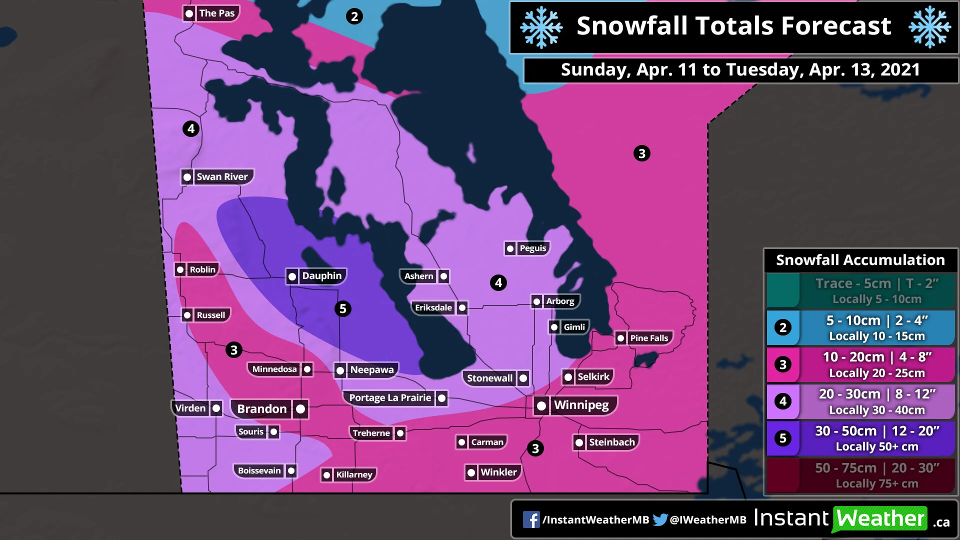
Winter Returns to Manitoba With a Multi-Day Snowstorm Starting Sunday Night; Widespread Snowfall Totals Between 15-30cm Across Southern Manitoba
/After a rather mild start to the weekend across Manitoba with double-digit daytime highs on Saturday, there will be a rude awakening as we head towards the end of Sunday and into the beginning of the week. Temperatures are still in the upper single-digit or low teens this afternoon for much of Southern Manitoba although that is expected to change as colder air floods into the province. During the overnight hours, we will see temperatures continue to cool down reaching near the freezing mark in many areas or the lower single digits by Monday morning. The colder air will be accompanied by a stalled out low-pressure system that will linger and merge with another system over the next few days providing ample moisture for persistent moderate to heavy snowfall beginning Monday morning (it will start Sunday night for Southwestern Manitoba along the Saskatchewan border) and continue into Tuesday. Total accumulation over the 72 hour period could exceed the 30cm mark around the Dauphin area. Please pay attention to the fact that this snowfall will be spread out over the span of 2-3 days so it won’t have as big of an impact compared to if it all came down within a 24 hour period.
Current weather radar as of Sunday afternoon indicates that an area of precipitation is currently bringing heavy wet snow to parts of Western Manitoba including the Swan River area and those along the Saskatchewan border. This will continue overnight with the snowfall mostly contained in the extreme western part of the province. Although by sunrise, we’ll see another system from Northern Ontario enter into the eastern part of the province and begin the merge with the other system that was bringing heavy snow to Western Manitoba and parts of Saskatchewan.
The precipitation with this newly merged system will wrap back around into Manitoba throughout the day on Monday and into the overnight hours. This will bring widespread heavy snowfall to much of the southern portion of the province with the heaviest accumulation expected during the afternoon. By the evening, we’ll see the bulk of the moisture focused on the Interlake region giving areas further to the south like Winnipeg and Brandon a break. Another blast of heavier snowfall is expected during the morning hours of Tuesday and into the afternoon. Snowfall will finally come to an end as we head into the later afternoon and evening hours on Tuesday with only flurries lingering around past the midnight hour.
The total accumulation from this multi-day event could reach as high as 30-50cm in a zone that includes the Dauphin area as indicated in the latest data. This could change and it’s possible that the data is overdone due to temperatures being near the freezing mark. Most of Southwestern Manitoba and the Interlake region can expect general amounts between 20-30cm except for a pocket that includes Brandon, Minnedosa and Roblin who could see less precipitation and keep totals closer to 10-15cm. The rest of Southern Manitoba including Winnipeg and Southeastern Manitoba is currently on track for totals between 10-20cm, but again this could end up being lower due to temperatures near the freezing mark and the potential for some mixing.


