First Widespread System Snowfall of the Season for Southern Ontario With Up to 5-15cm Possible Between Tuesday & Wednesday
/It sure feels like someone just flipped the switch between fall and winter! We have gone from near-record-breaking temperatures at the start of November to now looking at a very snowy forecast for the next week. We got a taste of this over the weekend with snow squalls dumping locally significant snowfall accumulation to parts of the snowbelts around Lake Huron and Georgian Bay.
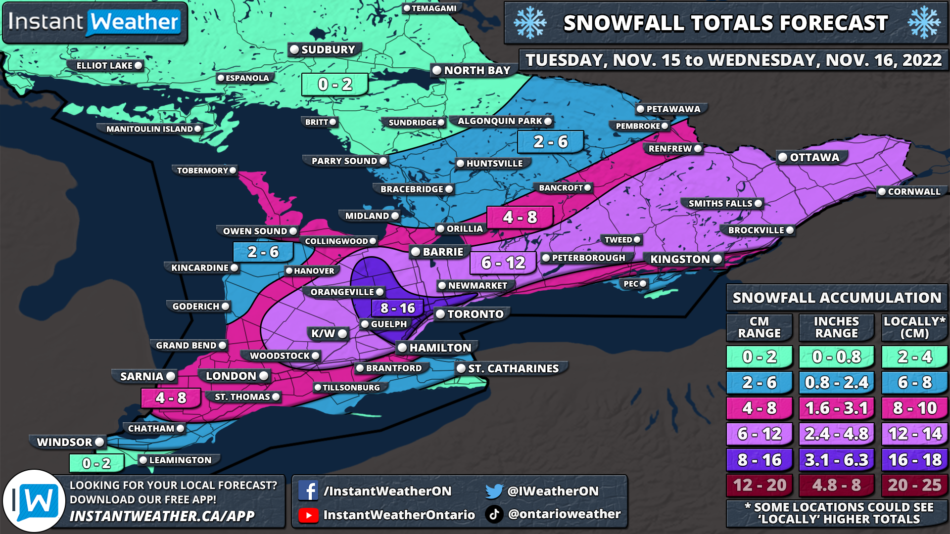
Now it’s the rest of Southern Ontario’s turn to face the wintery wrath of Mother Nature as we are tracking a potential system to bring accumulating snow starting late Tuesday. When the precipitation finally tapers off throughout the day on Wednesday, we will be looking at widespread accumulation ranging from 6-12cm with locally higher amounts up to 16cm through parts of the GTA and into the Dundalk Highlands. In the wake of this system, our focus will turn back to the lakes as we watch the risk of more snow squalls east of Georgian Bay and even northeast of Lake Erie for the end of the week.
The complexity of the next 48 hours when it comes to the weather will begin Tuesday late morning or early afternoon. There is a brief window of opportunity where we may see a localized band of lake effect snow develop off the western shoreline of Lake Ontario. The target of this band would be the Burlington, Oakville and Mississauga region with a quick few centimetres of snow along with reduced visibility possible. Normally, this wouldn’t be even noteworthy, however, it’s early in the season and even weak events tend to have implications on traffic throughout the GTA. So be aware of some possible travel delays in the western GTA during the afternoon on Tuesday.
Fast forward to later in the day, we expect to see the first effects of the system starting with Extreme Southwestern Ontario along with those along the Lake Erie shoreline by Tuesday evening. As is typical with the first ‘major’ system-related snowfall event in Southern Ontario, there will be a divide between the cold and warm air. This will make determining the exact precipitation type difficult, but at this point, it appears that the Windsor and Chatham region will remain warm enough to see just rain and those directly along the shorelines where temperatures are kept a few degrees warmer thanks to the warm waters of Lake Erie. Further north, it will be primarily snow extending from Sarnia, through London and into the GTA. Again, those along the shoreline in the GTA will see less snow and more rain due to Lake Ontario keeping the temperature slightly above the freezing mark.
Moderate to heavy snowfall will continue overnight with the worst conditions found during the predawn hours of Wednesday. There is also some indication that we may see lake enhancement off the western shoreline of Lake Ontario and into the Dundalk Highlands which will lead to boosted snowfall rates in this area. For Eastern Ontario, the snow won’t start until early Wednesday morning with the heaviest accumulation occurring later in the morning and early afternoon. We will begin to see the snow clearing from west to east late on Wednesday morning in Southwestern Ontario and by the mid-afternoon in Eastern Ontario. It should be fully moved out of Southern Ontario by the late afternoon.
Here is an advertisement so we can pay the bills:
When it comes to the expected snowfall totals from this system, it will be quite uneven due to the presence of lake enhancement from Lake Ontario. Based on the latest data, we believe a small pocket to the northwest of Lake Ontario (excluding those directly along the shoreline) that includes Halton Hills, Brampton, Orangeville and Shelburne will see the most snow from this event ranging from 8-16cm. Otherwise, totals will generally range from 6-12cm for a big chunk of Southern Ontario that extends from K/W, through the GTA, into Peterborough and Eastern Ontario.
We are expecting slightly less with 4-8cm being forecasted for Southwestern Ontario including Sarnia, and London due to the lower snowfall ratio and potential for rain mixing in and reducing the total accumulation. This is also the case through Central Ontario further to the northwest as the bulk of the moisture will be focused on regions south and east of Lake Simcoe. Limited accumulation is expected in Deep Southwestern Ontario and the Niagara region as they will be staying on the warm side of this system and see mostly rain.
As mentioned at the start of the forecast, we are watching what could be our first multi-day snow squall event of the season for regions east of Georgian Bay starting Friday and lingering into the weekend. By the end of the weekend, some localized regions around Parry Sound and Muskoka could be measuring snow in feet (1ft = 30cm) instead of centimetres! Although, there is still some uncertainty in the exact strength of the lake-effect snow and the wind direction. We may also see some fairly prolific squall activity off the northeastern shoreline of Lake Ontario and Erie which would bring significant accumulation and major travel issues to the Niagara and Kingston regions on Friday into Saturday. More details on that in the coming days.
Here is another advertisement so we can pay other bills:


