
Multi-Day Snowfall Event Across Manitoba Starting Late Tuesday Could Dump Up to 30cm of Snow by the End of the Week
/
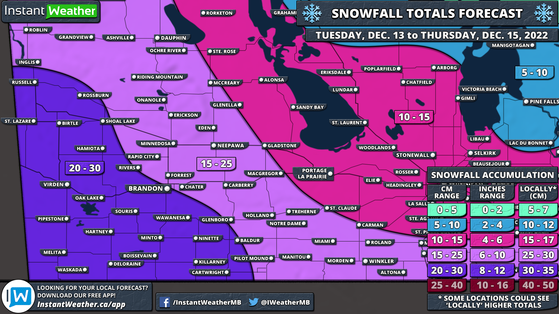
NOTE: You can click on the map to open a zoomable image which will be easier to read.
While the winter has started off on a slow note across Manitoba, that is about to change this week with a Colorado Low tracking through the province starting Tuesday evening. This will set the stage for a multi-day snowfall event as multiple rounds of precipitation affect southern parts of Manitoba between Wednesday and Friday. By the time the system moves out on Friday, we expect that total snowfall accumulation could range from 20 to 30cm in the hardest-hit locations.
The first effects of the Colorado Low will begin being felt early Tuesday evening as the initial band of precipitation crosses across the North Dakota border and into Southwestern Manitoba. As a result, the worst conditions will be found in locations such as Killarney, Boissevain, Brandon and Virden with the heaviest snowfall rates. By midnight, the moderate to heavy snowfall will have spread all across Southern Manitoba with the heaviest snow along the international border. Snow will continue overnight and into Wednesday morning although it will become more scattered later in the morning. Flurries and light snow will linger throughout the day on Wednesday and pick up in intensity towards the late afternoon and evening.
Overnight Wednesday, the focus will turn to Southwestern Manitoba with those further east getting a break from the snow. Steady snow is expected to affect regions along the Saskatchewan border into early Thursday morning before tapering off by sunrise. Another round of snow will move in during the afternoon on Thursday starting with the eastern sections of the province and slowly tracking to the west. The overnight hours on Thursday will be dominated by steady light snowfall continuing into the early part of Friday before the system responsible for this snowy weather finally moves out by the end of Friday.
Here is an advertisement so we can pay the bills:
NOTE: You can click on the map to open a zoomable image which will be easier to read.
As we will be dealing with multiple rounds of snow over the next few days, forecasting the exact accumulation is a little tricky. This isn’t a short event that lasts for 6-12 hours which is generally easier to forecast compared to a multi-day event. This also means that the impacts will be substantially less significant as the snow will fall over a long period and allow road crews to keep up with the accumulation on roads
With that being said, it appears the highest snowfall totals will be found in the southwestern corner of Manitoba with up to 20-30cm of snow expected over the next 48 hours. This includes Virden, Brandon, Milita and Killarney. 10-20cm of this snow will be on the ground by the end of Wednesday with an additional 5-10cm expected throughout the day on Thursday. The rest of Western Manitoba can expect total snowfall accumulation ranging from 10-25cm by the end of Thursday.

Moving to the eastern part of the province, the heavier snowfall totals will be contained to regions along the international border including Morden, Winkler, Emerson and Piney which could pick up around 15-25cm of snow over the next few days. South-central Manitoba including the Interlakes region along with Winnipeg and Portage La Prarie is forecasted to see 10-15cm of accumulation with the bulk of that snow coming on Wednesday.
However, there is some uncertainty on exactly how far north this system will track which would affect where the precipitation cutoff occurs. If the bands of snow make it further north than expected, these locations could certainly overachieve the forecast and approach the 15-20cm mark. Especially when it comes to elevated areas around Morden and Miami.
Current indications suggest that we could see another 5-15cm of snow on Friday in addition to what we’ve forecasted over the next two days. We have decided to leave Friday out of this forecast as it is still a few days away and it’s important to see how these first two days play out before we talk about Friday. Be sure to check for an updated forecast late Wednesday or early Thursday.
Here is another advertisement so we can pay other bills:
