
Major Ice Storm Targets Southern Ontario Starting Wednesday & Significant Snowstorm for Central and Eastern Ontario
/Forecaster: Brennen Perry
Published: Tuesday, February 21, 2023
While this month has been a roller coaster when it comes to the weather across Southern Ontario, we are heading back to winter as a major winter storm targets our region over the next few days. This will come in the form of prolonged freezing rain for Southwestern Ontario, ice pellets across the GTA and heavy snow in Central and Eastern Ontario. Precipitation is expected to start Wednesday morning lasting into Thursday. The storm will have a significant impact to travel across Southern Ontario and widespread power outages are likely in the region that sees freezing rain.
Initial bands of precipitation associated with this system are expected to reach the Canadian border in Deep Southwestern Ontario from Michigan around the noon hour. It will likely start as some light snow mixed with ice pellets before changing over to ice pellets and freezing rain by the early afternoon. Snow will also spread further to the northeast, reaching Southwestern Ontario and the GTA by the mid-afternoon. This will lead to rapid snowfall accumulation over the afternoon before it transitions over to ice pellets.
Conditions will continue to progressively worsen into the evening with intense icing ongoing from Sarnia through London and into Hamilton right at the height of the rush hour. Heavy ice pellets will be a concern throughout the GTA mixed in with snow and some freezing rain. Snow will start to affect Central and Eastern Ontario by the late evening continuing overnight. Some parts of Deep Southwestern Ontario including Windsor, Chatham and along the Lake Erie shoreline may inch above the freezing mark overnight which would reduce the freezing rain impact.
Conditions will be very treacherous starting from Wednesday late afternoon and into the predawn hours on Thursday. Travel should be avoided if possible until continues to improve later Thursday. Especially in the area expecting significant ice accretion with a thick layer of ice developing on untreated surfaces.
Here is an advertisement so we can pay the bills:
Strong winds gusting between 60-80km/h are also expected by the evening on Wednesday and continuing overnight. This will further enhance the impact of both the freezing rain leading to power outages and blowing ice pellets/snow or even localized blizzard conditions in areas further north.
Precipitation will slowly taper off from west to east beginning just after midnight. So the worst of the freezing rain will be finished by the early morning hours on Thursday. While snow will continue across Central and Eastern Ontario throughout the morning.
Another round of precipitation will move across our region during the afternoon on Thursday bringing patchy freezing rain throughout Southwestern Ontario and the GTA. Further north, we will see ice pellets or light snow across Central and Eastern Ontario during the afternoon and evening.
As the system finally exits our region by late Thursday, it will usher in much cooler air in time for the weekend. Morning lows on Friday could dip into the -20s for some parts of Southern Ontario!
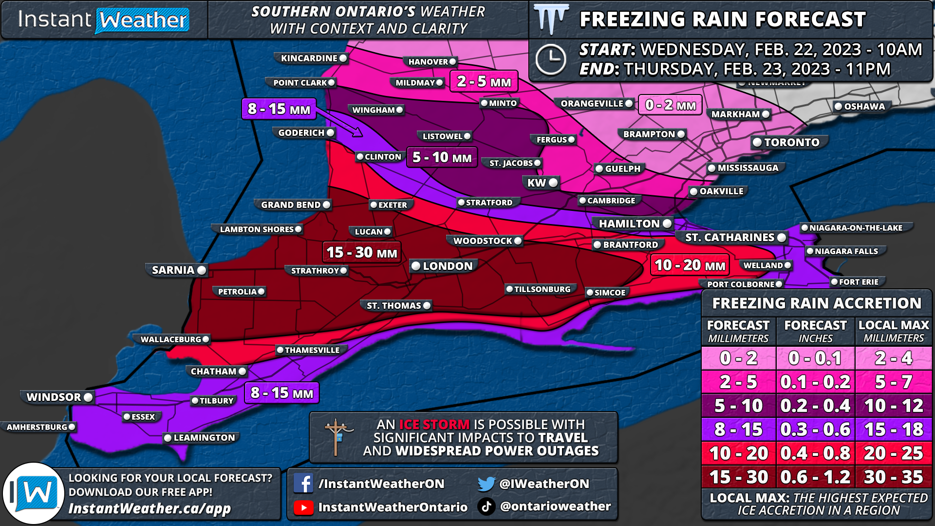
NOTE: You can click on the map to open a zoomable image which will be easier to read.
When it comes to the overall ice accretion and snowfall accumulation, the forecast becomes tricky as it will depend on the exact surface temperature. Even if the temperature is a fraction of a degree colder or warmer than expected, it could mean the difference between heavy freezing rain and rain or ice pellets. As such, it’s important to focus on the overall impact which is expected to be similar no matter if you see freezing rain, ice pellets or snow.
With that being said, we believe the hardest-hit area when it comes to the freezing rain will extend from Sarnia through London and into Woodstock. This zone could pick up to 15-30mm of ice accretion, but this will depend on the surface. For Windsor and Chatham into the Hamilton/Niagara region, ice accretion is expected to range from 6-12mm and maybe up to 15mm in localized pockets (especially in more elevated regions like the Hamilton Mountain). Less freezing rain is expected the further north you go as we see more ice pellets and snow across the GTA and Central/Eastern Ontario.

NOTE: You can click on the map to open a zoomable image which will be easier to read.
The focus on the snow will be in Eastern Ontario where the Ottawa Valley is likely to see 25-40cm of accumulation by the end of Thursday. It should be noted that some models are showing less moisture making that far north so the potential for this region to underperform the forecast isn’t out of the question. For the rest of Eastern and Central Ontario, snowfall totals will end up somewhere around 15-30cm.
As we go south of Lake Simcoe the snowfall accumulation will become less clear as ice pellets mix in and reduce the overall snow total. We are looking at 10-20cm from Goderich and into the Toronto region although that could end up on the lower end due to the ice pellets. And less than 10cm of snow is expected through Deep Southwestern Ontario and north of Lake Erie where freezing rain is the concern.
Here is another advertisement so we can pay the bills:
