
Spring on Pause: Wintry Blast Brings Snow, Ice, and Heavy Rain to Ontario This Weekend
/
NOTE: You can click on the map to open a zoomable image which will be easier to read.
Forecaster: Brennen Perry
Published: Friday, March 24, 2023
As spring arrives on the calendar, it seems Mother Nature has a different plan for Ontario this weekend. An approaching low-pressure system from the US Midwest is set to bring a mix of wintry precipitation, starting Saturday morning and lingering into Sunday.
Early Saturday morning, rain will begin in Deep Southwestern Ontario, affecting areas like Windsor, Leamington, and Chatham. As the system moves northeastward, colder air will create freezing rain across much of Southwestern Ontario. The worst conditions are expected in elevated regions such as the Dundalk Highlands, along the Niagara Escarpment, and the Hamilton Mountains, including areas like Orangeville, Shelburne, Guelph, Kitchener, and Halton Hills. Freezing rain will last for several hours on Saturday morning and early afternoon. Some minor freezing rain could also be an issue across the GTA and the Niagara region, but areas closer to the lakeshore will see less ice due to slightly warmer temperatures.
By noon, many areas will transition from freezing rain to rain, but higher elevations may experience freezing rain for a few more hours. Central and Eastern Ontario will see snow starting in the early afternoon, with ice pellets mixing in later in the day. The extent of ice pellets is uncertain and may affect overall snowfall totals. As temperatures drop in the evening, any remaining precipitation will transition to flurries or light snow across Southern Ontario.
NOTE: You can click on the map to open a zoomable image which will be easier to read.
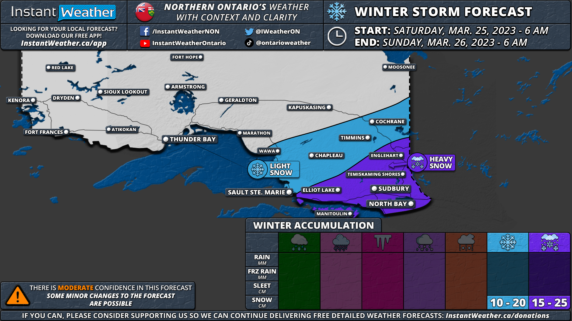
Northeastern Ontario is in for a classic snowstorm, starting Saturday afternoon around Sudbury and North Bay. Heavy snow will continue into the evening and overnight, creating poor travel conditions across most of the southern portion of Northeastern Ontario, including Elliot Lake, Sudbury, North Bay, and Temiskaming Shores.
Overall accumulation will vary greatly, depending on the exact precipitation type and temperature. The highest snowfall totals will be in Northeastern Ontario, with up to 15-25cm possible. Central and Eastern Ontario can expect a quick 5-10cm of snow on Saturday afternoon before transitioning to ice pellets. Around 2-5cm of ice pellet accumulation is expected across Central and Eastern Ontario.
The worst icing is expected around Orangeville, Kitchener, Woodstock, Guelph, and York Region, with several millimetres of ice accretion possible. Some higher elevations could see 8-10mm of accretion, leading to ice damage and localized power outages. Heavy rainfall will also be a concern for Southwestern Ontario and the Golden Horseshoe, with up to 25-50mm of rainfall expected in Deep Southwestern Ontario, potentially causing flooding.

NOTE: You can click on the map to open a zoomable image which will be easier to read.
Strong wind gusts will accompany the system, with the strongest gusts expected during the late morning and early afternoon hours on Saturday. Damaging gusts up to 90-100km/h are possible along the northeastern shoreline of Lake Erie, including Port Colborne and Welland. Occasional 90km/h gusts may also affect the Lake Ontario shoreline and Southwestern Ontario. Winds in Central and Eastern Ontario will range from 60-80km/h.
The combination of wintry weather and strong winds will likely lead to poor travel conditions, especially in areas experiencing freezing rain, ice pellets, and snow. It's advisable to avoid travel during the early part of Saturday. Conditions may improve slightly later in the day, but travel will likely remain difficult into Sunday.
Please note that this is a preliminary forecast and is subject to change. While confidence in the exact track is high, there could still be changes in precipitation type and timing. Stay tuned for an updated forecast by late Friday, including a detailed timeline for each region.
Here is an advertisement so we can pay the bills:
