Weekend Winter Storm To Bring Heavy Snow, Prolonged Freezing Rain or Significant Rainfall to Northern Ontario

NOTE: You can click on the map to open a zoomable image which will be easier to read.

We are monitoring a system set to affect Northern Ontario this weekend which will bring a mixed bag of precipitation to the region depending on your location. Impacts will vary from heavy snow to the northwest of Thunder Bay, prolonged freezing rain through the Geraldton area and heavy rainfall for Northeastern Ontario. This will all begin tonight as an approaching system starts to spread rain across southern parts of Northeastern Ontario along the Lake Superior shoreline

Moisture will continue to be pumped into Northern Ontario throughout the overnight hours as precipitation slowly spreads to the northwest. By Saturday afternoon, the outer bands of the precipitation will encounter colder air resulting in an area of mixed precipitation developing somewhere from Marathon through Moosonee. It will start out as some ice pellets or light snow before a more potent band of freezing rain will set up around the Geraldton area by late Saturday. Further west, the predominant precipitation type will be sleet and heavy snow affecting locations such as Thunder Bay and Armstrong. Precipitation will linger overnight although it will slowly taper off by Sunday morning as the system moves out of the region.

In terms of impact, those in Northeastern Ontario including Sault Ste. Marie, Elliot Lake, Sudbury and Timmins will stay on the warm side of this winter storm and see all rain with total accumulation ranging from 30-60mm by Sunday morning. For the Marathon and Moosonee areas, you will start off with some mixed precipitation for a few hours during the late afternoon and early evening on Saturday before switching over to regular rain. The biggest impact will be around Geraldton with the potential for up to 4-8mm of ice accretion from freezing rain along with some mixed precipitation. Icy road conditions and power outages are possible in this region.

Accumulating snow is possible for parts of Northwestern Ontario with Thunder Bay picking up between a trace to 5cm of snow plus ice pellets. The heaviest snow will be found to the north for the Armstrong and Fort Hope region which could see up to 10-20cm of snow from this storm by Sunday. In addition to this, there will be strong wind gusts late Saturday with gusts approaching 70-90km/h mainly for regions to the north of Georgian Bay.

Here is another advertisement so we can pay other bills:


First Multi-Day Winter Storm of the Season Could Bring Up to 20-30cm of Snow to Parts of Northeastern Ontario Starting Monday

NOTE: You can click on the map to open a zoomable image which will be easier to read.

Mother Nature isn’t wasting any time with giving a taste of wintery weather this week across parts of Northern Ontario. The calendar might still say October, but the next few days will feel like we skipped a whole month right into late November. While most parts of Northern Ontario have already seen the season's first flakes, we are watching a multi-day system that could bring accumulating snowfall to a wide swath of Northeastern Ontario. The snow will start for some on Monday and continue on and off with multiple waves over through Tuesday and into Wednesday with total accumulation over the three days adding up to 20-30cm in the hardest hit areas.

A low-pressure system is expected to stall over the Great Lakes starting Monday which will provide a steady stream of precipitation across Northern and Southern Ontario over the next few days. In addition to the multiple waves of precipitation, some colder air will flow in from the west starting Monday dropping temperatures to near or slightly below the freezing mark through Northern Ontario. With temperatures near the freezing mark, it is likely that precipitation will come down in the form of wet snow for the Kapuskasing and Chapleau region starting as early as Monday afternoon.

It’s important to note that this is very temperature dependent which will affect exactly how much snow a particular region receives on the ground. The precipitation may also change back to a rain/snow mix during the day on Tuesday as temperatures warm up slightly before going back below the freezing mark. Not to mention that the ground is still fairly warm so it may take some time before the snow starts accumulating and thus reducing actual accumulation. So this forecast isn’t saying that a particular location will have 20-30cm of snow on the ground by Wednesday, but rather that total snowfall over the three days will add up to that and it’s hard to say exactly how much will melt.

Snow will come in multiple waves with the heaviest snow expected Tuesday afternoon and lingering into Wednesday morning. The snow should taper off by the middle of the day on Wednesday, but scattered flurries may continue into Thursday. Those closer to the Quebec border and up around James Bay will see slightly warmer temperatures so precipitation will come in the form of rain for the most part. However, a few hours of heavy snow is possible late Tuesday into Wednesday as the colder air finally spreads further east.

As this system extends multiple days, it’s possible that the forecast may change as we get closer and see how the first part of the precipitation develops. We will be monitoring the latest data and updating our forecast with a more precise expected snowfall accumulation map by Monday. As we’ve mentioned throughout the forecast, the confidence in this event is low as is typical with the season’s first major snowfall. So be aware that changes are likely with our final forecast.

Here is another advertisement so we can pay other bills:


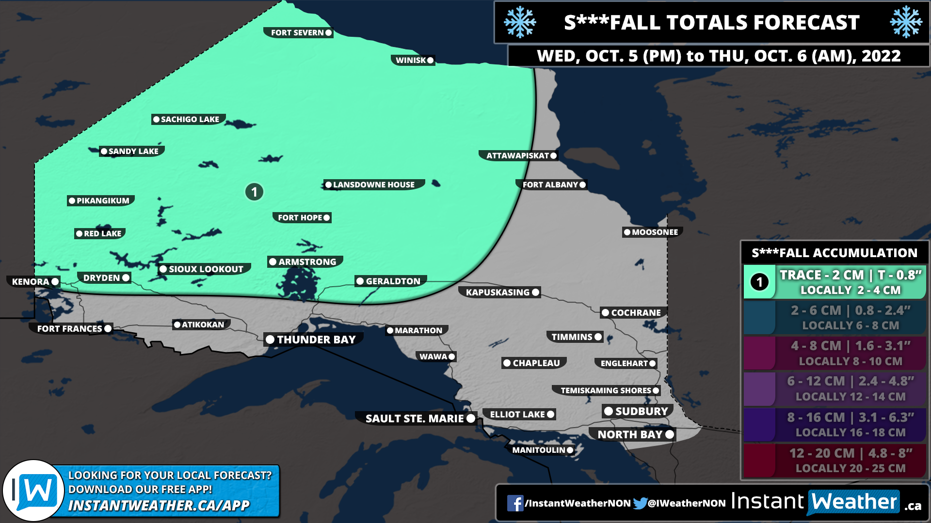
What The F...lurries? First Widespread Snowfall of the Season Starting Tonight Into Friday Morning Across Northeastern Ontario

NOTE: You can click on the map to open a zoomable image which will be easier to read.

It might still be a few weeks away from Halloween, but our forecast for this Thanksgiving Weekend is downright scary for those not ready for a taste of winter weather. Yes, it’s that time of the year when we must say the dreaded f-word for the first time! Parts of Northeastern Ontario are set to see the first flakes of the season starting Thursday evening and continuing into early Friday morning. Current indications suggest that the snow could come down heavy enough to lead to minor accumulation and as a result, some locations might be surprised with up to a few centimetres of that wet fluffy stuff on the ground as you wake up Friday morning.

The potential for wet snow will begin early this (Thursday) evening as a sharp cold front cuts across Northeastern Ontario. This will allow for temperatures to drop near the freezing mark over the next few hours causing the ongoing rainfall to slowly transition over to wet snow by tonight. Persistent light to moderate snowfall will continue overnight for locations such as Chapleau, Timmins, Cochrane and Englehart.

Depending on how cold the temperature can get and the intensity of the snowfall, some of these locations may wake up to some accumulation, but it will quickly melt as temperatures warm above the freezing mark after sunrise. Further to the southeast through the Elliot Lake, Sudbury and North Bay regions, they could also see some flurries overnight and early Friday morning, but the air temperature is still expected to remain slightly above the freezing mark which means any snow will melt on contact.

Heading into the Thanksgiving Weekend, it looks like the cold air will be sticking around at least for the next few days. Overnight lows will continue to flirt with the freezing mark all weekend. This also means that there is the chance for more wet flurries, although it appears that most of the activity will be continued to Far Northern Ontario like Fort Severn, Winisk and Attawapiskat. We should see somewhat of a warm-up by Monday/Tuesday with the potential for double-digit highs for some parts of Northern Ontario.

Here is another advertisement so we can pay other bills:


Autumn Sets In Across Ontario With a Significant Cooldown & the First Snowfall of the Season

NOTE: You can click on the map to open a zoomable image which will be easier to read.

As we head deep into the fall season with the arrival of October, it’s expected to see some colder air and even the risk of the familiar white flakes we haven’t seen in a while. For most, it still comes as a shock especially considering how warm the start of fall has been across the region. The rude awakening will occur later this week as a cold front ushes in colder temperatures across Northern and Southern Ontario. You still have time to get out there and enjoy the nice fall weather - double-digit daytime highs are expected to continue on Wednesday for all of Ontario and Thursday for Southern Ontario.

We will see the colder air making its way into Northwestern Ontario by late Wednesday as the cold front moves through. The cold front will also be accompanied by some light precipitation, initially coming down as rain showers. However, with temperatures expected to drop to near the freezing mark overnight Wednesday into Thursday morning, it could transition over to some wet snow. This is predominantly for Northwestern Ontario along the Manitoba border where the temperatures will be cold enough for snow. We don’t expect much in terms of accumulation since the ground will still be fairly warm and any snow will melt on contact.

NOTE: You can click on the map to open a zoomable image which will be easier to read.

The cold front will continue to progress to the southeast throughout the day on Thursday. This will bring the risk of some wet snow to parts of Northeastern Ontario overnight Thursday as temperatures hover near the freezing mark. There is some indication that the snow could be quite heavy at times so it may leave some minor accumulation through Chapleau and Timmins with up to 2-4cm possible. However, this is questionable so it’s not guaranteed to accumulate and will come down to exactly how cold it can get.

NOTE: You can click on the map to open a zoomable image which will be easier to read.

For Southern Ontario, the story for most of the week will be almost perfect fall weather with mild temperatures in the high teens or low twenties and not much in terms of rain. By Friday this will change with the arrival of the cold front early Friday which will result in a rapid drop in temperatures. The daytime high on Friday will be around 10 degrees colder than just 24 hours earlier! It will get even colder overnight into Saturday morning with many areas at or slightly below the freezing mark leading to the widespread risk of frost.

It appears that Southern Ontario should avoid the season’s first snowfall for the most part. There still could be some flurries early in the morning on Friday through North Bay and into Algonquin Park, but it shouldn’t be widespread. Temperatures will moderate somewhat heading into next week which should ensure we don’t get any snow just yet. It’s only a matter of time though and it does look colder towards the middle and end of October so there might be a chance for many areas to see their first flakes of the season.

Here is another advertisement so we can pay other bills:


NORTHWESTERN ONTARIO: Significant Severe Thunderstorm Risk This Evening & Overnight (Mon, May 30, 2022)

NOTE: You can click on the map to open a zoomable image which will be easier to read.

We’re dealing with an ongoing significant severe weather outbreak in the US that will eventually impact parts of northwestern Ontario this evening and into the overnight hours. Isolated tornadoes, damaging wind gusts, large hail, flooding and frequent lightning are all possible. Tornadoes will be especially possible in the red area of the map, highlighted with the number 4 and the dotted region, close to the international border. Fort Frances and surrounding areas may have the strongest potential for significant severe weather and dangerous tornado activity. Environment Canada has already issued a Tornado Watch for regions like Fort Frances and areas close to the international border.

There is also a marginal risk for severe weather in parts of northeastern Ontario, close to the Quebec border but it’s a bit uncertain at this point in time.

If we see any rotation on radar, we will do our best to notify all those who have our free app Instant Weather and who subscribe to our premium Text Message Alerts as well as through Facebook, Twitter, etc.

Just want to say a huge thank you to all those who share our updates and support our team and community! It really makes a huge difference.

More details ASAP.

Winter’s Grip on Ontario Continues With Freezing Rain Risk in the South and Heavy Snow in the North Between Wednesday and Thursday

It might be officially spring, but it appears that Mother Nature missed the memo as we are expecting a system to bring a messy mix of wintery precipitation across Ontario over the next few days. The effects of this storm will begin to be felt in Deep Southwestern Ontario during the predawn hours on Wednesday. This includes Windsor, Chatham, Sarnia and London where temperatures will be hovering near the freezing mark throughout the morning. As a result, there is the risk of freezing rain for several hours as the precipitation works its way throughout the region. Do note that this will be very temperature dependent and some areas may see just all rain if it’s slightly warmer than expected.

Later in the morning on Wednesday, we will see the precipitation push to the northeast into the rest of Southwestern Ontario and the GTA with the risk of freezing drizzle or rain. Again, this will be very dependent on the temperature so the worst conditions will be found in the higher elevations (K/W, Guelph and Orangeville etc.) with less of an impact closer to the lakeshore. This could lead to some icy driving conditions during the morning commute on Wednesday so be sure to leave plenty of time to get to your destination.

In terms of ice accretion, the heavier precipitation will be found throughout Deep Southwestern Ontario southeast of Lake Huron so they could pick up around 2-4mm of ice accretion. The rest of Southwestern Ontario and the GTA is expected to experience more scattered freezing rain so it won’t be as sustained with less than 2mm of total icing. We will see the freezing rain risk linger into the afternoon as temperatures still remain slightly below the freezing mark, but there will be a break in the precipitation which should help limit the impact. Temptarues will slowly rise above the freezing mark towards the evening and overnight into Thursday.

Another area of concern we’re closely watching is east of Georgian Bay and up into Northeastern Ontario. This area has the risk of freezing rain starting late Wednesday afternoon continuing into the overnight and Thursday morning. Those in Central and Eastern Ontario can expect between 2-6mm of ice accretion by Thursday morning as temperatures climb above the freezing mark overnight. The more prolonged freezing rain will be found north of Georgian Bay including Elliot Lake, Sudbury and North Bay. Several hours of heavy freezing rain with up to 6-10mm of ice accretion is possible. This amount of icing will likely lead to some power outages and impact to travel so consider avoiding any non-essential travel through the region.

Conditions on Thursday will do a complete 180 across Southern Ontario as warmer air push temperatures into the double digits during the morning and afternoon. This will be accompanied by scattered showers and rain with even the risk of an isolated non-severe thunderstorm. Strong to damaging wind gusts will also be an issue early Thursday morning and into the afternoon. Current indications suggest that regions east of Lake Huron into the GTA could see wind gusts ranging between 70-90km/h with locally stronger gusts up to 100km/h along the shorelines. More details on this will be covered in a separate wind forecast to be issued on Wednesday as we get closer to Thursday.

For Northern Ontario, the story will be more of a traditional snowstorm for a wide swath of the area. Along with the aforementioned prolonged freezing rain just north of Georgian Bay. Snow has already begun to move into Northwestern Ontario this evening around the Manitoba border. It is expected to spread eastward throughout the overnight and into Wednesday. The heaviest snow will be found from Thunder Bay through Geraldton and Moosonee starting Wednesday afternoon and evening. Conditions here will be quite poor with blowing snow and rapid accumulation - road and highway closures are likely later in the day on Wednesday. There will be a short break for the snow early Thursday morning, but another round of heavy snow is expected to move through Northeastern Ontario (it should remain east of Thunder Bay closer to Wawa and Timmins) during the day on Thursday.

Total snowfall accumulation in the hardest-hit regions will likely exceed 20cm and could even approach 30cm by the end of Thursday. This includes Geraldton, Kapuskasing, Wawa and Cochrane while Thunder Bay will likely top out at around 15cm. Lower snowfall accumulation of around 5-15cm is expected through Chapleau and Timmins where sleet and freezing rain mixing in will reduce accumulation. Sault Ste. Marie, Elliot Lake, Sudbury and Temiskaming Shores will experience mainly freezing rain with significant icing of 6mm+ possible. The freezing rain will transition over to regular rain Thursday morning as the temperature climbs above the freezing mark.