First Snowstorm of the Season Takes Aim at Saskatchewan and Manitoba With Up to 30cm of Snow Between Wednesday and Friday

A slow-moving system currently developing over Alberta is expected to bring a wintery blast of heavy snow beginning early Wednesday morning through Central Saskatchewan around Meadow Lake. This band of snow will slowly spread to the southeast towards the Yorkton region by late Wednesday morning and start to affect parts of Southern Manitoba during the day on Wednesday.

There was some uncertainty regarding precipitation type particularly through Southern Manitoba although the latest data appears to point towards a colder solution which would allow for more snow instead of rain mixing in and decreasing accumulation. As such, Winnipeg and most areas except for right along the International border will see predominately snow (likely in the form of heavy wet snow) with accumulation occurring later in the day as temperatures drop further below the freezing mark. Keep in mind that this event is still heavily temperature-dependent and a few degrees can make the difference between a few slushy centimetres and 20+cm of snow.

Snow will continue overnight into Thursday as the low-pressure system responsible for this snow stalls our and bands of precipitation wraps back in through Saskatchewan and Manitoba all day on Thursday. We will start to see some clearing later on Thursday for Saskatchewan with it lingering into early Friday for Southern Manitoba. All of the snow should be finished by Friday morning across the region except for some scattered flurries across Southwestern Manitoba.

As for accumulation, this is really tricky due to the issue with temperatures which can be hard to predict with melting. Although our target zone for the heaviest snowfall includes parts of Southeastern Saskatchewan around Yorkton and extending into Southern Manitoba around the higher elevations for Dauphin and the Interlakes region. This area can expect between 20-30cm of accumulation, but some models are pointing towards as much as 40-50cm of accumulation in localized areas mainly around Dauphin. The rest of Southern Manitoba including Winnipeg and Brandon extending through Central Saskatchewan will generally see between 10-20cm of accumulation over the next three days with most of the accumulation coming on Thursday.

Winter Returns to Saskatchewan With a Multi-Day Snowstorm Starting Sunday; Locally Up to 30-50cm of Snow in the Hardest-Hit Regions by Tuesday

After a rather mild start to the weekend across Saskatchewan with double-digit daytime highs on Saturday, there will be a rude awakening as we head throughout the day on Sunday and the beginning of the week. Temperatures have already cooled down substantially during the early part of Sunday and the temperatures are only expected to get colder later in the day. By Sunday evening, we’ll see much of South-central and southeastern Saskatchewan at the freezing mark or slightly below and dropping several degrees below the freezing mark after midnight. The colder air will be accompanied by a stalled out low-pressure system that will linger and merge with another system over the next few days providing ample moisture for persistent moderate to heavy snowfall beginning Sunday afternoon and continue through Monday and even into Tuesday. Total accumulation over the 72 hour period could exceed the 30cm mark in some areas within Southeastern Saskatchewan including Yorkton. Please pay attention to the fact that this snowfall will be spread out over the span of 3 days so it won’t have as big of an impact compared to if it all came down within a 24 hour period.

Current weather radar as of Sunday afternoon indicates that an area of precipitation has developed over Southeastern Saskatchewan and has begun to switch over from rain to wet snow as temperatures slowly cool down. Regina has likely already started to see the wet snow with the Yorkton area switching over in the coming hours. The first round of snow will be ongoing throughout the evening and overnight into early Monday morning focused on the Yorkton, Regina and Moosomin area. This band of snow will be quite narrow so the heaviest accumulation will be very localized and not everyone will see it. We will see the snow become more scattered and lighter after sunrise on Monday with expected accumulation on the ground as you wake up ranging from 15-25cm for the corridor between Regina and Yorkton and between 5-15cm for other areas including the City of Regina.

A second round of snow will enter the eastern part of the province as the previous system that brought us the snowfall tonight will merge with a secondary system over Northern Ontario. The precipitation with this newly merged system will wrap back around into Saskatchewan late Monday and continue overnight into Tuesday. This round won’t be as intense as the one tonight, but it will be more sustained and widespread lasting through much of the day on Tuesday. Snowfall will finally come to an end as we head into the evening hours on Tuesday with only flurries lingering around past the midnight hour. Expect an additional 10-20cm of snowfall accumulation throughout Southeastern Saskatchewan with locally 20-25cm in some areas closer to the Manitoba border.

The total accumulation from this multi-day event could reach as high as 30-50cm in a zone through parts of Southeastern Saskatchewan between Regina and Yorkton. Keep in mind that this is very temperature-dependent and with the ground still wet from the earlier rainfall, the snow may struggle to stick to the ground at first and resulting in lower snow totals. The rest of Southeastern Saskatchewan can expect general amounts between 15-30cm depending on your location. The further north and west you go, the less accumulation that is expected from this storm. Looking at around 10-20cm for the Moose Jaw and Swift Current area and between 5-10cm for Saskatoon.

Significant Wind Storm and Accumulating Snowfall To Start Off the Week Across Saskatchewan; Gusts Over 100km/h With 6–12cm of Snowfall Accumulation Possible

It’s almost the end of March and we’re well into spring, but the weather across Saskatchewan tonight into Monday will make it feel more like winter. A strong system developing over the Alberta Rockies is expected to move into the province late Sunday evening and into the overnight hours bringing with it the threat of very strong wind gusts and widespread snowfall. The worst conditions will be found during the morning and afternoon on Monday with persistent light to moderate snowfall and wind gusts up to 100-115km/h in some areas.

We’ll see the strongest gust along the Alberta border including Swift Current, Shaunavon, Kindersley and Assiniboia with the maximum wind gusts ranging from 100-115km/h. The rest of Southern and Central Saskatchewan will see wind gusts approach damaging levels around 90-105km/h including Moose Jaw, Saskatoon and Regina with weaker winds to the north. The strong wind gusts will weaken as we head into the evening on Monday although they’ll likely continue to be quite strong up to midnight.

For much of Saskatchewan, we’re looking at between 6-12cm of snowfall accumulation between Monday and Tuesday. Some localized regions may pick up near 15-20cm although the data isn’t super strong so we’re holding with the 6-12cm zone as our maximum. There will be lower amounts along the international border with only a few centimetres expected. The snow will continue throughout Monday and slowly taper off overnight into early Tuesday morning.

Pre-Christmas Major Snowstorm to Deliver a Wintery Blast to Saskatchewan With Up to 25-40cm and Blizzard Conditions Possible on Tuesday

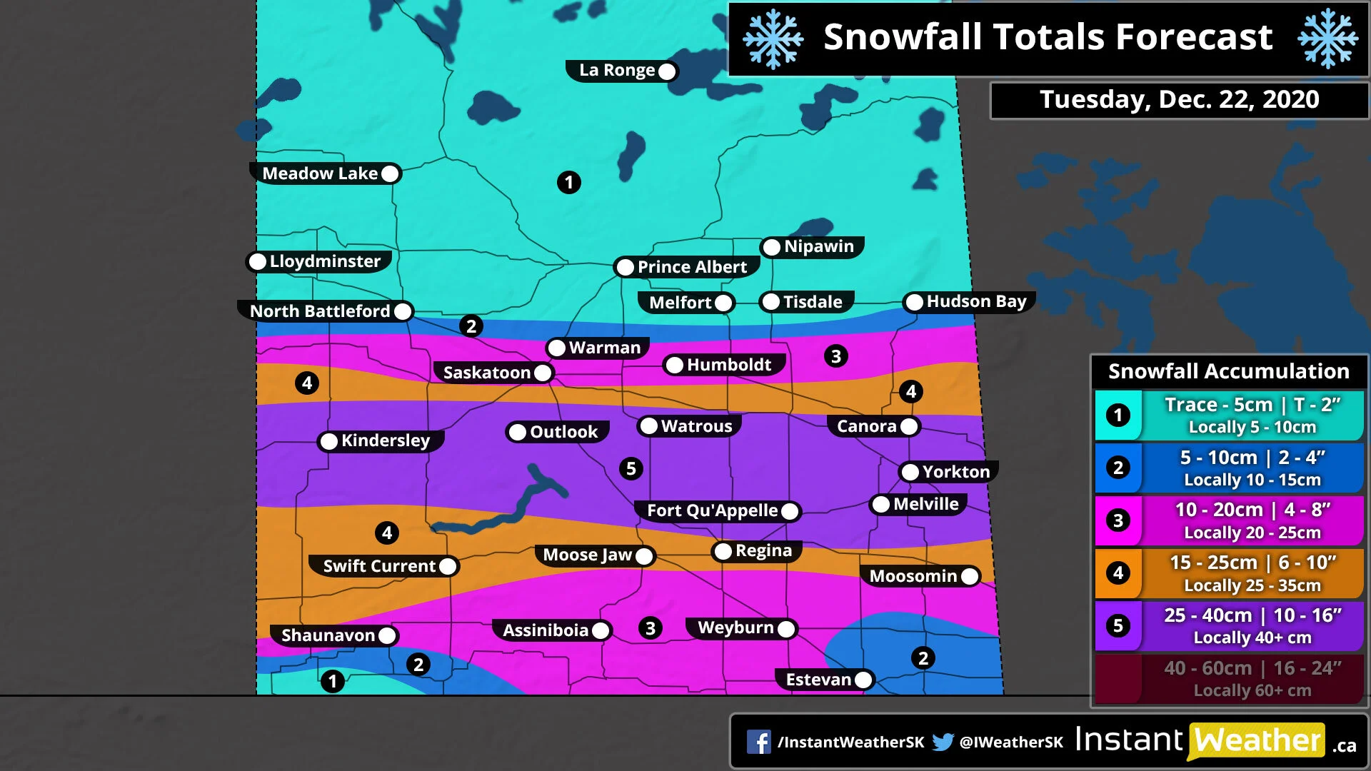
A significant winter storm is set to deliver a heavy dumping of snow to parts of Southern and Central Saskatchewan just a few days before Christmas. The hardest-hit regions from Kindersley through to Yorkton has the potential to pick up between 25-40cm of snowfall accumulation by the end of the day on Tuesday. Strong wind gusts between 60-80km/h will also be associated with this system which combined with the heavy snow, could result in blowing snow and blizzard conditions in some areas late Tuesday.

The first bands of snow will enter the western part of the province along the Alberta border just around midnight and spreading eastward through the morning on Tuesday. We expect the worst conditions will occur through Tuesday afternoon and early evening along with those strong wind gusts picking up and creating near-zero visibility out on the roads. Non-essential travel should be avoided during this time as highway closures are quite likely and you may become stranded.

Snowfall will continue late Tuesday and even into early Wednesday morning but most of the expected snowfall accumulation will be on the ground by the end of the day on Tuesday. Flurries will linger into Wednesday morning especially near the Manitoba border with conditions rapidly improving overnight Tuesday.

As we mentioned above, the heaviest snowfall totals will be found from the Alberta border around Kindersley, eastward through the Fort Qu’Appelle and Yorkton area. Current indications suggest that this area has the potential to see snow totals between 25-40cm by the time the snow tapers off late Tuesday or Wednesday morning.

Other areas including Swift Current, Moose Jaw and Regina can expect final snowfall accumulation between 15-25cm with localized amounts near 30cm. Lesser amounts are expected to the north and south with Saskatoon, Shaunavon and Weyburn seeing between 10-20cm of snowfall accumulation. The southeast and southwestern corners of the province will see less than 10cm of accumulation including Estevan.

In the wake of the storm, very cold air will flow into the province pushing temperatures to near or below -20°C across Saskatchewan by Wednesday morning. Wind chills will make it feel like -35°C or colder in some areas Wednesday morning and again on Christmas Eve morning near the Manitoba border. Temperatures will warm up as we head into Christmas morning with morning lows in the upper negative single digits or low teens. With these cold temperatures expected, it’s near-certain that Saskatchewan will see a White Christmas this year - our updated White Christmas outlook will be out on Tuesday.

A White Christmas Appears Very Likely Across Saskatchewan With Potential Snowstorm on Tuesday

This is a PRELIMINARY outlook - we will be updating it throughout the week as we get closer to Christmas.

This is a PRELIMINARY outlook - we will be updating it throughout the week as we get closer to Christmas.

It looks like a White Christmas is almost certain with snowfall already on the ground through most of Southern and Central Saskatchewan. The snowpack should be safe with only a brief window of above freezing temperatures this weekend and staying below freezing from Monday through to Christmas Day. As we head into the middle of the week, even colder Arctic air will flood into the province. Overnight lows will easily drop below the -20°C mark Tuesday night and perhaps again on Wednesday Night. The current temperature forecast across Saskatchewan for Christmas Day has temperatures within the negative single digits.

We’re also closely monitoring a potential snowstorm that could affect Central Saskatchewan on Tuesday. General snowfall totals between 10-20cm with locally as much as 25cm look possible from Kindersley to Yorkton. The track of this system is still uncertain so we’ll be waiting for a few more days until we put together a preliminary forecast. Check back later for more details!

On behalf of the entire Instant Weather team, we’d like to wish everyone a happy and joyful holiday season! We’ll continue to be here keeping you informed on any impactful weather over the holiday season and into the New Year. Here’s hoping that 2021 is much better to everyone than the dumpster fire that 2020 has been! :)

Record-Breaking Blizzard Takes Aim at Saskatchewan This Weekend; Up to 50cm of Snow Possible by Monday

It has been a fairly quiet start to the winter across much of Saskatchewan but that is about to change substantially as we watch the potential for a dangerous blizzard that will affect much of Southern and Central Saskatchewan this weekend. Wind gusts up to 50=75km/h combined with intense snowfall rates will produce blowing snow and causing near-zero visibility out on the roads with the worst conditions expected throughout the day on Sunday.

It’s quite possible that this storm could be a record-breaker with widespread snowfall totals that we haven’t seen in quite a long time. The hardest-hit regions could see as much as 30-50cm of snow over the next few days and that might even be a low estimate. It’s not out of the question that some areas pick up 60 or even 75cm in localized regions. Outside of the heavy snowfall, there is also the potential for several hours of an ice pellet and freezing rain mix in Southeastern Saskatchewan late Sunday into Monday morning which could lead to a light coating of ice on untreated surfaces and icy driving conditions.

We expect the first round of snowfall to begin early Saturday morning with some light to moderate snowfall moving into the Western part of the province from Alberta. This will continue into the day on Saturday but will mainly affect the central part of our regions such as Kindersley, Saskatoon and Prince Albert where the heavier bands of snow will be located. The first round of snow isn’t expected to bring much snowfall to the more southern part of Saskatchewan, but the second round won’t be as forgiving so don’t think it’s over when you see little accumulation by the end of Saturday.

As we head into Sunday morning this is when conditions will really start to deteriorate as we see the main system track into the province and the wind starts to pick up. Very heavy snow will stretch from Southwestern Saskatchewan through the southcentral region (Moose Jaw etc.) and into the Hudson Bay area starting Sunday afternoon. Current indications suggest that those in the southeastern corner of the province including Regina, Weyburn and Yorkton could start with a few hours of ice pellets or freezing rain into Sunday evening although it’ll begin to transition over to heavy snow from west to east.

By Sunday evening, conditions will be downright dangerous with snowfall rapidly accumulating combined with strong wind gusts through Southern Saskatchewan. We will likely see some highway closures due to the blowing snow and whiteout conditions so if possible, consider staying home until conditions improve on Monday. The system will begin to taper off during the early morning hours on Monday as it moves off into Northern Manitoba and should be fully done by the noon hour.

When it comes to total snowfall accumulation by Monday, there will be a wide swath from Shaunavon, Moose Jaw, Saskatoon and Hudson Bay that picks up generally between 30-50cm of snow. As we mentioned above, the potential for some areas to overachieve that forecast and see as much as 60-75cm is there. Now, the next zone that includes the Regina area is tricky to forecast given that they’ll initially start with some ice pellets. How fast the ice pellets turn over to snow will determine exactly how much snowfall that region receives. At this point, we believe it will hold the totals below the 30cm mark for Regina so we have them in the 20-30cm zone but if they switch over quicker than expected then up to 40cm isn’t out of the question for them.

Snow totals will be lower the further north you go due to the lack of precipitation and towards the southeast corner of the province where freezing rain will be the more predominant precipitation type. On the topic of freezing rain, several hours of freezing rain which could be heavy at times is expected through the Estevan and Moosomin area during the afternoon and evening on Sunday. Up to 3-6mm of ice accretion is possible in this area which combined with the strong wind gusts could bring down tree branches and cause localized power outages along with icy roads.

Alberta Clipper to Deliver Southern Saskatchewan’s First Widespread Accumulating Snowfall Starting Friday

As Alberta braces for the first winter storm of the season with more than 25cm of snow possible throughout the Rockies, Saskatchewan will also be into the crosshairs of the same system. This will bring the potential for the first snowflake of the season for much of Southern Saskatchewan and even maybe a few centimetres of accumulation depending on the location. For the areas that do see the accumulation, general amounts will range from 4-8cm stretching from a zone from the Alberta border through Swift Current and towards Estevan.

We’ll begin to see the first effects of the Alberta Clipper near the Alberta border during the early to mid-afternoon on Friday. The light to moderate snowfall will continue for much of the day on Friday and into the overnight hours as it slowly spreads further to the east. South-central Saskatchewan such as Moose Jaw and Regina will see the snow sometime during the early evening. Snowfall will slowly taper off from west to east beginning early Saturday morning and fully clearing out of the province by noon.

As mentioned, the highest snow totals will be around the Swift Current, Assiniboia, Weyburn and Estevan area where we are forecasting between 6-12cm although it will likely be closer to the lower part of that range so 10+cm is unlikely. Extending outside of this region, we can expect to see a few centimetres of snowfall accumulation through Shunavon and Moose Jaw. All other areas will see just wet flurries with little to no accumulation. Please note that temperatures will be hovering near the freezing mark during the day on Friday so it might take some time for the snow to start sticking to the ground. This makes forecasting snow totals tricky as some of the expected accumulation could melt right as it hits the ground.

Warmer & Dry Over The Next 10 Days

Valid Wednesday, Septermber 30th, 2020

Wednesday, September 30th | 12z NAM - 2M Temperature

Wednesday, September 30th | 12z NAM - 2M Temperature

The great divide between Canada’s changing Autumn season and reluctant heat that has parts of the country reeling in above normal temperatures is expected to set up camp across Saskatchewan over the next several days. A warmer pattern is set to evolve over the next three days with temperatures steadily climbing into the upper teens across much of western Saskatchewan. Southwestern areas will openly rope in the warmth with communities through the region feeling the heat as temperatures climb into the 20’s. The heat will continue to expand across the province with many communities climbing over the 20°C mark especially as we head through the upcoming weekend. What a way to kick off October!

The colder weather remains east through parts of Manitoba and especially once you move into Ontario where chilly temperatures will continue to ride a roller coaster through the province bringing the chance there for wet snow at times. Enough about the cold, it’s locked through Ontario, lets take a look at the incoming heat!

September 30th, 2020 | 00z ECMWF - 2M Temperature

September 30th, 2020 | 00z ECMWF - 2M Temperature

Looking at the latest European guidance you can see the heat lifting through the northern plains of the U.S. as it gets drawn into Saskatchewan pushing temperatures well above seasonal. The map above shows anticipated temperatures at 6pm Friday, October 9th. Temperatures over the next 10 days are expected to remain above seasonal for much of the period throughout much of the province. There is some guidance hinting at a cool down come mid-to-late month so be sure to enjoy this late season heat while you can.

September 30th, 2020 | 00Z ECMWF Total Precipitation

September 30th, 2020 | 00Z ECMWF Total Precipitation

Along with the increasing temperatures much of the province will continue to remain dry with very little in the way of rainfall during the next 10 days. The latest guidance continues to show very little in the way of precipitation to go along with the heat. It’ll be quite a picturesque pattern for those who love outdoor activities and taking in the fall colors over the next several days with many likely to hope it continues into the Thanksgiving weekend. We’ll have more on Thanksgiving in a separate article.. You can see how much of the precipitation is locked across portions of Ontario and Eastern Canada with British Columbia also seeing there typical share of rainfall as Central Canada remains fairly stable and dry.

September 30th, 2020 | 00z ECMWF Total Snowfall

September 30th, 2020 | 00z ECMWF Total Snowfall

With the warmer temperatures and drier conditions prevailing across the province communities won’t be worrying too much about snowfall as the Eastern-half of Canada feels the chill from waves of colder temperatures and even wet snow at times - accumulating in a few communities from now until Thanks-giving. Eventually as we near the middle of the month and after the festive holiday we’ll likely see the potential begin to build further west into parts of the province, again after the Thanks-giving weekend.

Chilly Air to Invade Saskatchewan for the First Week of September With Temperatures Near the Freezing Mark

Valid: Tuesday, September 8, 2020

Forecast Discussion

It’s hard to believe, but we’re already heading into September and that means we have to say goodbye to the hot scorching temperatures we’ve seen this summer and hello to the colder fall nights. And Mother Nature isn’t wasting any time with temperatures near or slightly below the freezing mark to start off the first full week of September across Saskatchewan.

We’ll begin to see the invasion of this chilly air overnight Sunday and into Monday with overnight lows in the low to mid-single digits. The temperatures will warm up slightly during the day on Monday with daytime highs around 7-12°C. We expect the coldest temperatures will occur overnight Monday and into Tuesday morning where many areas throughout the province will be hovering near the freezing mark or even the low single negative digits.

When it comes to the S-word, the temperature is certainly favourable for a few flurries but there isn’t much moisture expected in the region that will be near the freezing mark Tuesday morning so most areas likely won’t see their first snow just yet.

This cold snap will be brief though because temperatures will warm up substantially as we head into the middle and end of the week. By next weekend, we could be talking about daytime highs in the 20s!

+ Attribution

Icons made by Good Ware from www.flaticon.com
Icons made by Freepik from www.flaticon.com