
A Winter Storm Will Bring All Precipitation Types to the Maritimes to Remind Us That It Is Still Technically Winter
/
NOTE: YOU CAN CLICK ON THE MAP TO OPEN A ZOOMABLE IMAGE WHICH WILL BE EASIER TO READ.
Despite recent rain and mild temperatures across the Maritimes over the past couple of weeks, an incoming storm will bring a variety of precipitation types that will remind us that it is still winter according to the calendar. Light rain has already started to make its way into New Brunswick Wednesday afternoon and evening, spreading eastward across the width of the province. As we approach the overnight hours, that rain will transition to snow for Northern New Brunswick and the rain will begin in Prince County, PEI and Western Nova Scotia.
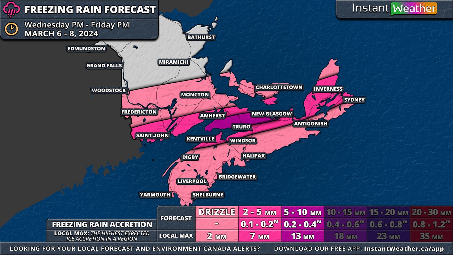
The situation becomes a bit messier starting around midnight as that’s when a persistent band of freezing rain will develop between the rain and snow due to an elevated layer of warm air. This layer of warm air will be shallower on the north side of the freezing rain band and as a result, there will be ice pellets, or sleet, mixed in with the snow here. The freezing rain will push southward during the early morning hours and will settle over Southern New Brunswick, namely the Fundy Coast, and Kings County by sunrise and lasting for a couple of hours. It will then shift further south in the mid-morning to impact Cumberland County, the Northumberland Shore and eventually Northern Cape Breton until the evening. As the storm begins to exit the region, there is the possibility of light freezing drizzle briefly extending across the rest of Nova Scotia.
This extended period of freezing rain will lead to 2-5mm of ice accretion stretching from St. Stephen to Sydney with the possibility of a pocket of 5+mm across Cumberland, Colchester and Pictou Counties. Wind gusts are expected to top out at around 70km/h and when mixed with even small amounts of ice accretion, this could be enough to bring down tree branches and powerlines. Temperatures are expected to remain close to or just below the freezing mark in the areas that will be impacted the greatest by the freezing rain until Saturday, so it won’t be too long before the ice melts.
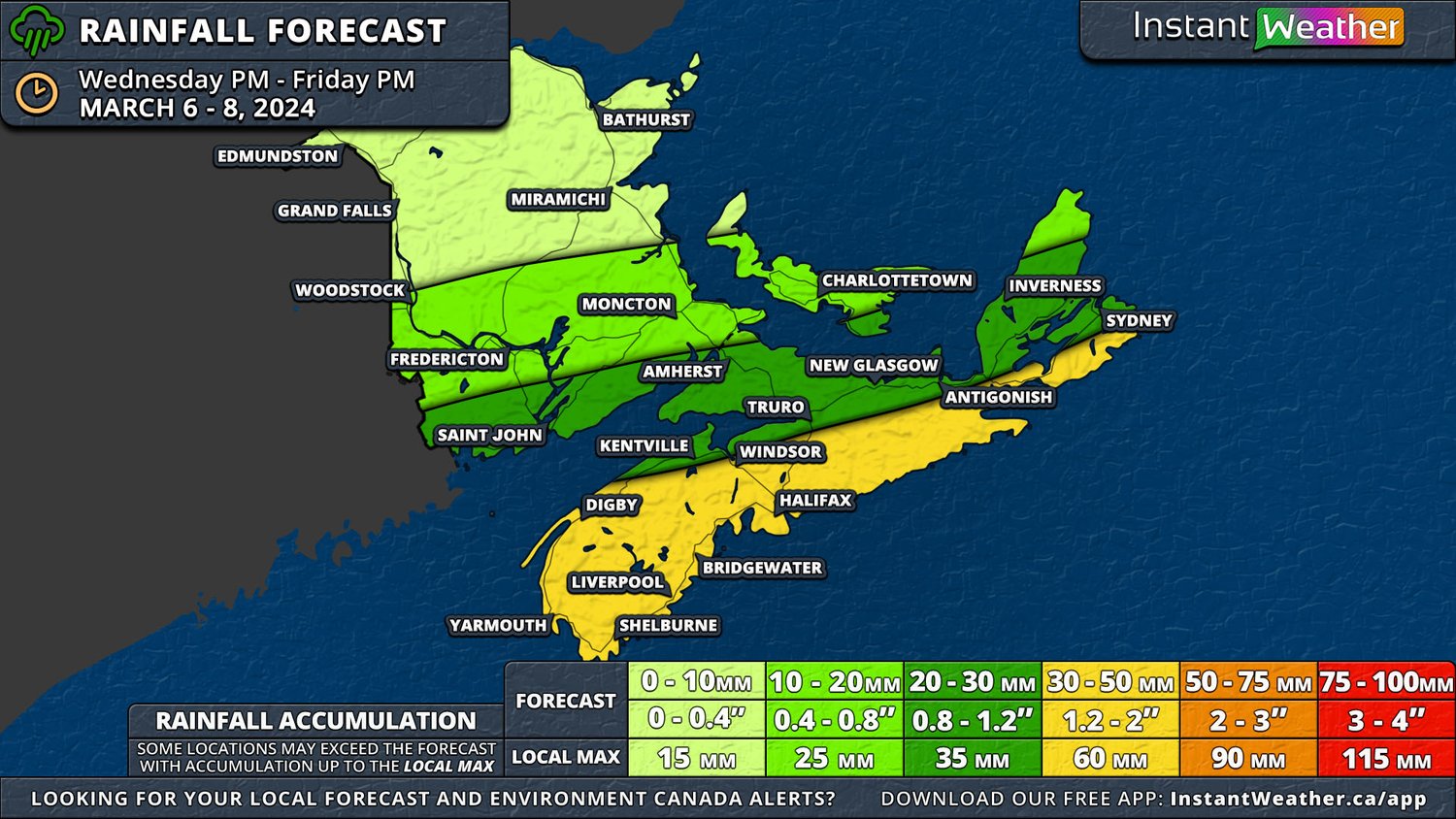
While the freezing rain is a major component to this storm, steady rain falling over an already-soaked Nova Scotia and Southern New Brunswick will once again raise concerns over flooding. Almost this entire area can expect over 30mm of rain, including freezing rain, with upwards of 50mm in Western Nova Scotia and along the Atlantic Coast. The rain will start to make its way out of the region in the mid-afternoon Thursday and in the evening, some freezing drizzle and light snow will take its place across much of mainland Nova Scotia until Friday morning. A rain-snow mix is expected to linger in Guysborough County and Cape Breton from Friday morning and into the evening.

Meanwhile, to the north, the story with this storm will be heavy snow which will be mixed with ice pellets in some areas. A substantial area of Central New Brunswick and Queens County can expect at least 10cm of snow, but Eastern New Brunswick and Prince County could see upwards of 30cm. These snowfall totals include ice pellets, which could end up accounting for as much as 10cm. Most of the snow will dissipate by Thursday evening, but there could be some light flurries lasting into the overnight hours.

The exact positioning and spread of the ice pellets will be dependent on how far north the layer of elevated warm air extends and its thickness. In order for ice pellets to fall, the layer needs to be thick enough for snow to start melting, but not too thick to have it melt completely, and then high enough above the ground that it can refreeze in colder air before hitting the ground. Freezing rain on the other hand, requires a thicker layer of warm air that results in the snow from above to completely melt as it passes through and a shallow cold layer underneath means the raindrops don’t freeze in the air, but rather, they freeze on contact with the surface. An easy way to remember the difference is to think about doughnuts: freezing rain is a glaze on a doughnut while ice pellets are sprinkles on top.

