Do You Want to Build a Snow Turkey? Parts of Ontario to See Up to 10-20cm of Snow for Thanksgiving
/
NOTE: YOU CAN CLICK ON THE MAP TO OPEN A ZOOMABLE IMAGE
October has started on a wild note in Ontario this year. After experiencing record-breaking temperatures soaring past 30°C earlier in the week, we're now shifting gears. The recent days have showcased more traditional fall weather with rain and chilly evenings. Yet, as the forecast suggests, it seems Mother Nature might be pulling a spooky Halloween prank on our region a bit early.
Indeed, the forecast hints at the season's first snowfall covering a vast portion of Northeastern Ontario and extending to the northern regions of Southern Ontario. By Tuesday, some areas could see snow accumulations reaching 10-20cm.
GOOGLE AD (NOT ENDORSED BY INSTANT WEATHER)
As the temperatures gradually dip overnight heading into Sunday morning, anticipated rainfall is expected to transition into wet snow in areas such as Timmins, Cochrane, and Chapleau in Northeastern Ontario. The snow will slowly draw south, enveloping Sudbury, North Bay, and parts of Central Ontario. Considering the ground's retained warmth, most snowfall is likely to melt upon impact.
The snow is set to persist from Sunday night into Monday for Northeastern and Central Ontario. With temperatures possibly plummeting a few degrees below freezing in certain areas, we may start to see the snow accumulating on the ground by Monday morning.
During late Sunday and early Monday, the snow could be heavy at times, leading to slush-covered roads and diminished visibility. It's essential for drivers to be cautious, especially since many might not have transitioned to winter tires yet. Monday will continue the potential for scattered flurries, eventually turning into rain showers as temperatures climb. Although the snow might still be present in Northeastern Ontario by Monday night, it should dissipate by Tuesday morning.
NOTE: YOU CAN CLICK ON THE MAP TO OPEN A ZOOMABLE IMAGE
GOOGLE AD (NOT ENDORSED BY INSTANT WEATHER)
Predicting the exact accumulation is challenging. While models are good at estimating the amount of precipitation that will come from the sky, the ground's warmth and hovering freezing temperatures could result in much of the snow melting on contact.
Raw model data indicates that areas just north of Sudbury, like Timmins and Englehart, could experience the most snow. Here, upwards of 30cm might fall from the sky, but considering the factors mentioned earlier, the actual ground accumulation should end up between 10-20cm. These numbers are a rough idea and depend on various local dynamics.
The next few days carry the potential for both under and overperformance due to the expected amount of precipitation. Maximum accumulation is likely during Sunday night or early Monday. As Monday warms up, any snow gathered on the ground will quickly melt.
The rest of Northeastern Ontario away from the shoreline of Lake Superior and Georgian Bay including Sudbury, Elliot Lake, Chapleau and Cochrane can expect some minor accumulation ranging from 4 to 10cm by early Monday morning.
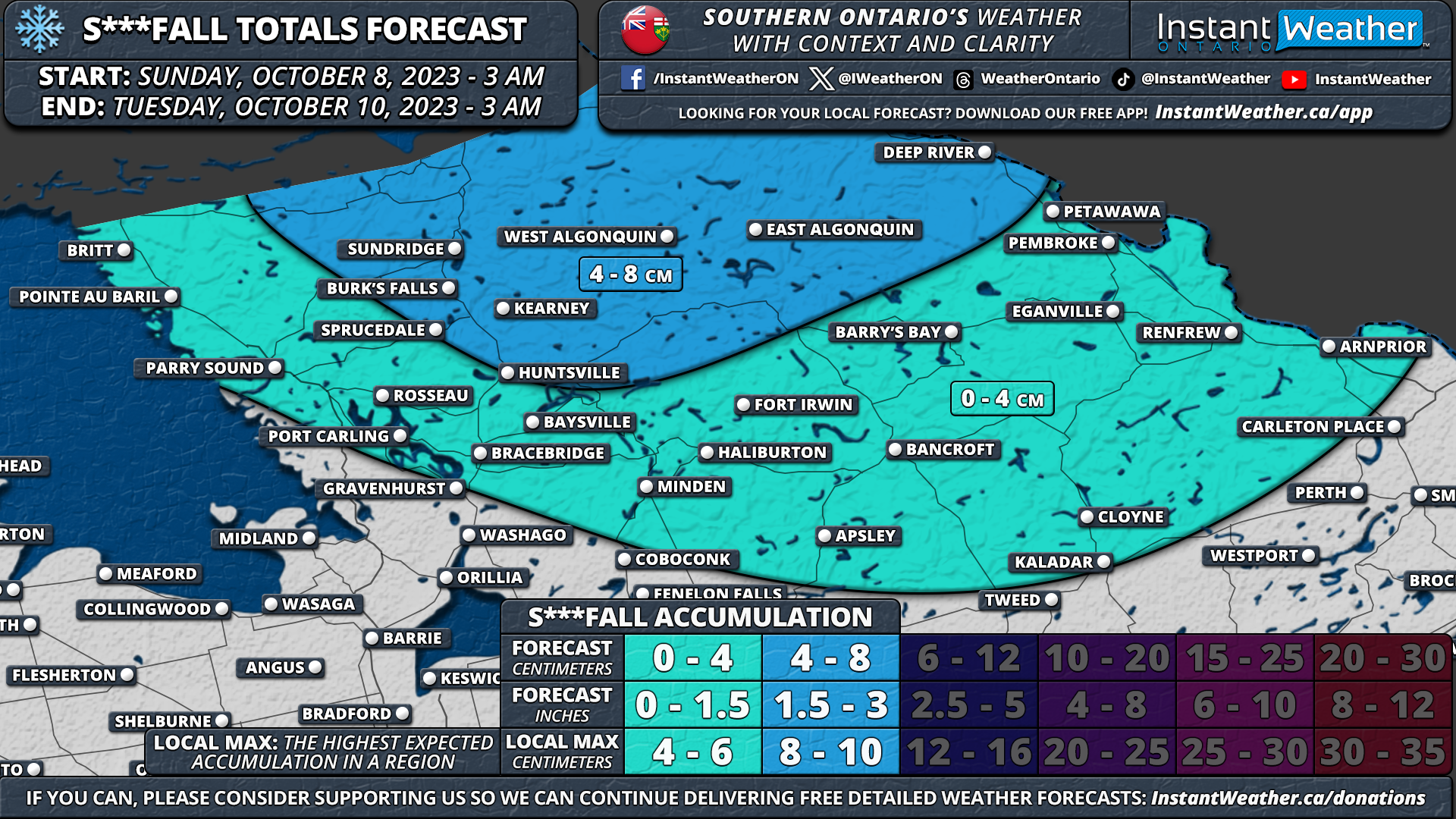
For Southern Ontario, Central Ontario might also experience the season's first few snowflakes, with accumulations possibly reaching 2-6cm in areas like Algonquin Park, Sundridge, and Huntsville. The rest of Central Ontario including Parry Sound, Bracebridge, Haliburton, Bancroft, Pembroke and Renfrew can expect a few flakes, but no substantial accumulation is anticipated.

NOTE: YOU CAN CLICK ON THE MAP TO OPEN A ZOOMABLE IMAGE
GOOGLE AD (NOT ENDORSED BY INSTANT WEATHER)
The imminent cold combined with the Great Lakes' warmth will bring the return of lake-effect precipitation in the coming days. Most of Southern Ontario will be spared from snow, but regions around Lake Huron and Georgian Bay could see rainfall totals of between 25-50mm by Monday's end, with some areas potentially receiving up to 75mm.
Elsewhere in Southern Ontario, intermittent showers are predicted, with the heaviest rainfall in Southwestern and Eastern Ontario. Regions in deep Southwestern Ontario and along the Golden Horseshoe might experience minimal rain, with less than 10mm of accumulation expected.
