Snow Squalls Could Bring Over 10cm of Snow to Parts of Ontario’s Snowbelt on Friday
/
NOTE: YOU CAN CLICK ON THE MAP TO OPEN A ZOOMABLE IMAGE
The chill is set to descend upon Ontario to wrap up the week, heralding the return of lake-effect snow in the traditional snowbelt on Friday. Some regions surrounding Lake Huron, Superior, and Georgian Bay could experience accumulations of over 10cm from the snow squall activity before it diminishes late Friday.
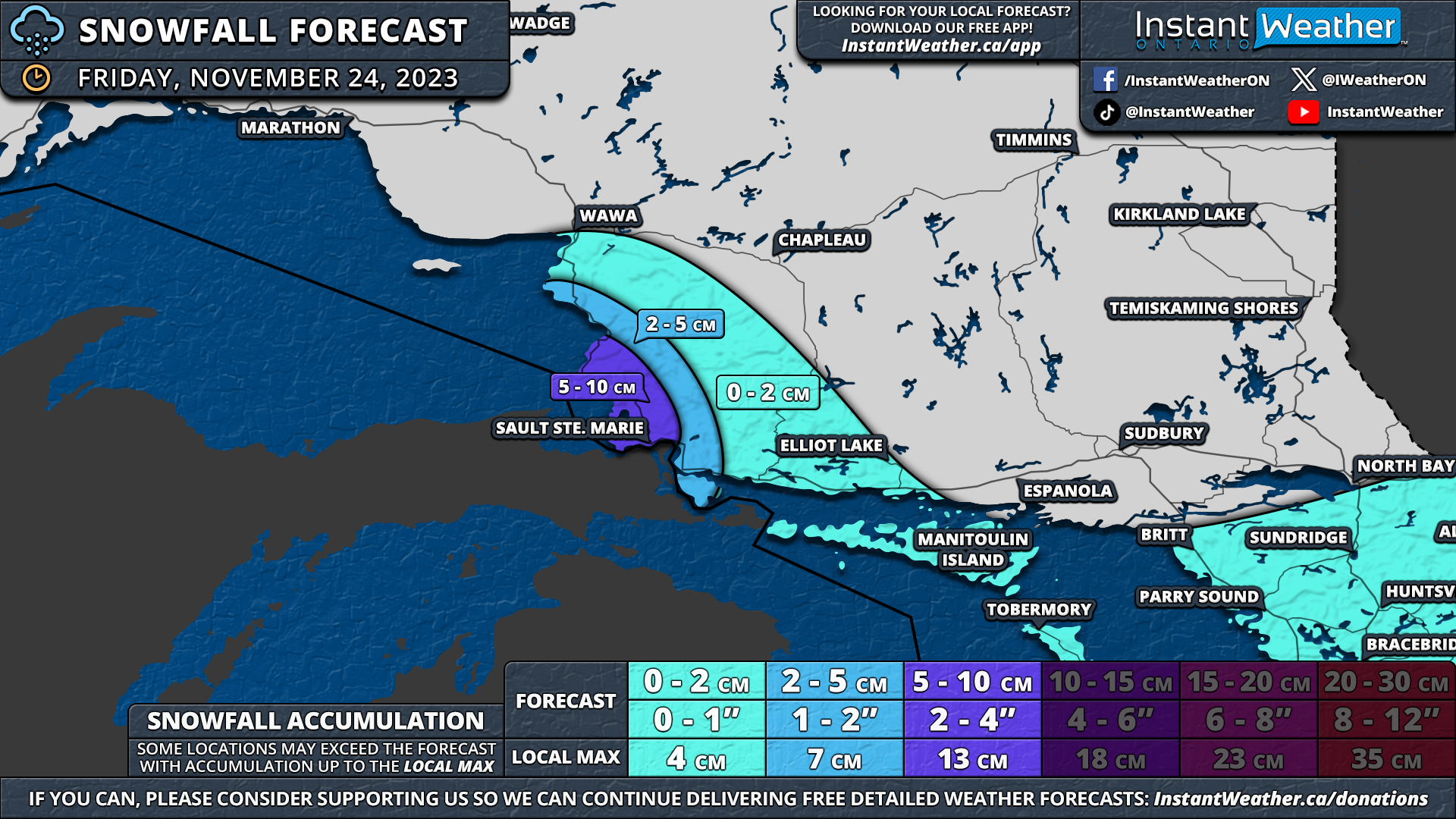
Lake-effect snow has already materialized off Lake Superior in Northern Ontario as of Thursday evening, accompanied by temperatures well below freezing. This trend is expected to persist overnight and into Friday, primarily affecting areas southeast of the lake, including Sault Ste. Marie.
Heading further south, temperatures are still above the freezing point, but this is anticipated to change in the coming hours. Lake-effect snow is expected to commence around midnight, likely remaining relatively unorganized for much of the night.
Current indications suggest the heaviest snowfall will be concentrated in Grey, Bruce, and Simcoe counties, with the activity becoming more organized by early Friday morning. Localized snow squalls are expected to persist throughout the morning and afternoon hours.
The Lake Huron squall is projected to come onshore around Point Elgin and extend inland towards Hanover, while the Georgian Bay squall will focus on the Wasaga Beach, Barrie, and Angus areas. However, it may extend into parts of the Northern Greater Toronto Area (GTA) at times.
Activity off Lake Superior should taper off by late Friday afternoon. However, around Lake Huron and Georgian Bay, lake-effect snow may linger into the evening and potentially even early Saturday morning before tapering off just after midnight. The most intense activity is expected during the morning and afternoon.
NOTE: YOU CAN CLICK ON THE MAP TO OPEN A ZOOMABLE IMAGE
As is typical with a lake-effect event, snowfall totals will vary considerably, depending on the exact placement of the squalls and their duration over a particular area. Our forecast predicts a general 5-10cm in locations including Port Elgin, Chatsworth, Hanover, Wasaga Beach, Angus, and Barrie.
There's potential for a few localized regions to accumulate up to 15cm, as one model, in particular, is aggressive with squall intensity. Conversely, some regions may struggle to reach the 5cm mark due to the localized nature of lake-effect snow.
Between 2-5cm of snow is possible for surrounding regions, including those northeast of Lake Huron and around the southern shoreline of Georgian Bay.
This potential also extends into parts of York Region due to the Georgian Bay snow squall occasionally reaching that far inland, although it isn't guaranteed, and the lake-effect snow may stay closer to the shoreline.
A few flurries are possible for the rest of Southwestern and Central Ontario, including much of the GTA away from the lake. No accumulation is expected, as there won't be enough snow to stick to the ground.
The scenario is similar off Lake Superior, with our forecast calling for between 5-10cm for locations, including Sault Ste. Marie. Again, some locations could exceed that, with upwards of 15cm possible. A few centimetres of snow are possible for the rest of the eastern shoreline of Lake Superior.
