Impactful Winter Storm Staying on Track to Bring Over 50cm of Snow, Significant Freezing Rain and Heavy Rain For the First Weekend of Spring in the Maritimes

NOTE: YOU CAN CLICK ON THE MAP TO OPEN A ZOOMABLE IMAGE WHICH WILL BE EASIER TO READ.

We’re approaching the first weekend of spring and what better way to celebrate than with an intense winter storm that could dump over 50cm of snow across parts of Northern and Central New Brunswick. The uncertainty regarding the storm’s track between major weather models has all but disappeared, with most models now favouring the northern path that is now expected to bring 50+cm of snow to Grand Falls, Woodstock, Bathurst, and through the Acadian Peninsula and Miramichi is still within the 30-50cm range. Further south, Fredericton can expect up to 30cm of snow mixed with ice pellets while Saint John and Moncton will receive 5-15cm along with rain and freezing rain. This region of 5-15cm of snowfall extends into Cumberland County in Nova Scotia and across much of Prince Edward Island, with the exception of Western Prince County, PEI where 15+cm of snow is likely.


GOOGLE AD (NOT ENDORSED BY INSTANT WEATHER)

New Brunswick

The snow will start making its way into the region from the southwest beginning mid-morning Saturday in Charlotte and York Counties and it will continue to spread across New Brunswick and into Prince Edward Island throughout the afternoon. Heavier snow is expected to follow this initial band starting in the late afternoon and early evening which will continue until Sunday morning. Parts of Northern and Central New Brunswick would be looking at 12 hours of snowfall rates of 2-4cm/hr, leading to rapid accumulations of 50+cm across a significant area. The snow will start to dissipate from west to east throughout Sunday morning.

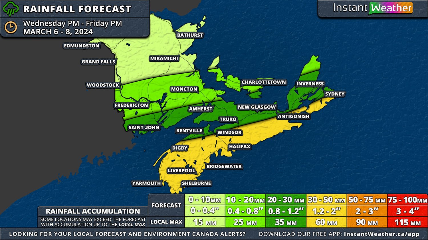
Southern New Brunswick will see the snow transition to rain and freezing rain Saturday evening and continuing until Sunday morning when there will be a brief switch back to snow and a bit of freezing rain before the precipitation ends. This region could easily see 10-50mm of rain, with higher amounts found along the Fundy Coast, from this storm on top of 5-15cm of snow from Saturday morning and afternoon.

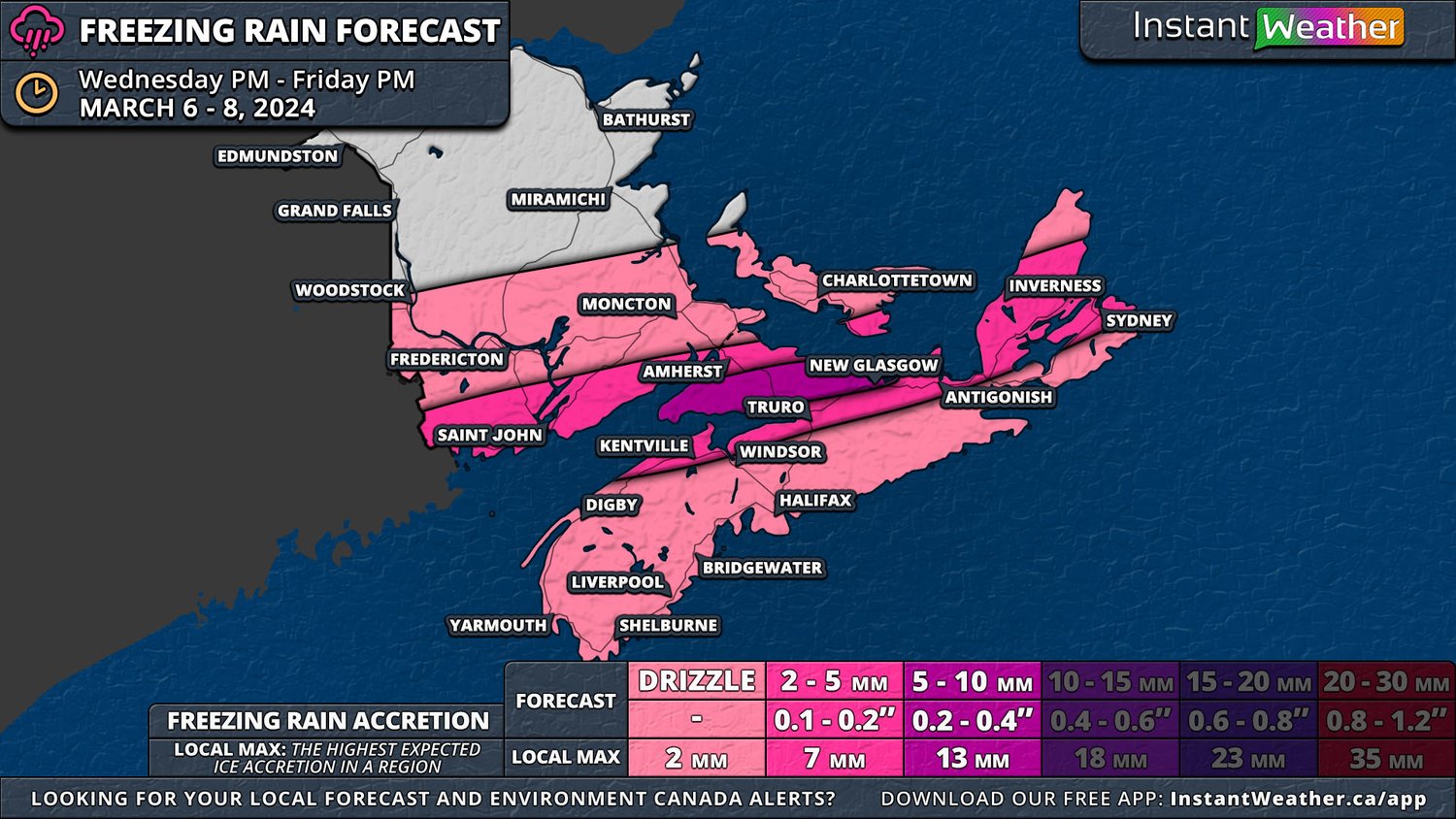
In between the bands of heavy snow and rain associated with this storm, there will be a band of freezing rain and ice pellets that will set up Saturday evening and make its way across Southern New Brunswick and into Western PEI through the overnight and continuing until Sunday morning. With the band of freezing rain becoming stationary for over 6 hours, ice will quickly begin to build-up and some areas could see accretions up to 10mm with locally higher amounts which is a significant amount of ice. The city of Fredericton, in particular, is in the area that will be hit the hardest. As the storm begins to exit the region, the band of freezing rain will shift southeastwards, bringing ice to the Fundy Coast, much of Eastern Nova Scotia and the rest of PEI.

This much ice build-up will be more than enough to create extensive damage to trees and power lines, resulting in widespread outages. Wind gusts will be in the 30-50km/h range on the backside of the storm, but temperatures are expected climb to a few degrees above freezing on Sunday afternoon across Southern New Brunswick which should assist in melting the ice. The freezing rain will be followed by a brief period of snow, which could be heavy and will bring snowfall totals up, especially in the area expecting 15-30cm.


GOOGLE AD (NOT ENDORSED BY INSTANT WEATHER)

Nova Scotia

The snow will start to spread into Western Nova Scotia early Saturday afternoon as the storm pushes into the region, however it will be light and short-lived flurries, leading to less than 5cm of accumulation across much of the province. There will be a break in precipitation for a couple of hours, at which time the temperature is expected to rise, and rain moves in beginning in the evening and continuing, heavy at times especially in the early morning hours, until mid-morning Sunday. We will start to see the rain move out of the region from west to east at that time and gradually ending across the province by the late evening Sunday with the possibility of a very brief transition over to freezing drizzle. Mainland Nova Scotia can expect widespread rainfall totals of 20-50mm while Cape Breton Island will see 10-30mm.


Prince Edward Island

In Prince Edward Island, the snow will start Saturday afternoon and last for several hours and resulting in 5-15cm across most of the province before switching to freezing rain and rain overnight. Prince County can expect upwards of 10mm of ice accretion and up to 20mm of rain while the rest of the Island may see light freezing drizzle along with 20-30mm of rain. The rain will continue into the morning and shortly after sunrise, there will be a transition back to snow from west to east that will last for a few hours as the storm makes its final push across the province before ending Sunday evening.

Significant Winter Storm Expected for the Maritimes for the First Weekend of Spring

NOTE: YOU CAN CLICK ON THE MAP TO OPEN A ZOOMABLE IMAGE WHICH WILL BE EASIER TO READ.

 We’re approaching the first weekend of spring and what better way to celebrate than with an intense winter storm that could dump over 50cm of snow across parts of Northern and Central New Brunswick.

There is still some uncertainty in the track of this storm between major weather models, with some favouring a northern path that would bring 30+cm of snow to Grand Falls, Woodstock, Miramichi, and Bathurst; while others shift the heavy snow further south to have a greater impact on Fredericton, Moncton and into Saint John. This southern shift would also lead to 15-30cm across Prince Edward Island and into Northern Nova Scotia. In our preliminary snowfall map, we’ve leaned towards the northern track as there is a bit more consensus among the models for this track at this point. It is likely that some changes will be made to this map as we draw closer to the weekend.


GOOGLE AD (NOT ENDORSED BY INSTANT WEATHER)

The storm will move through Southern Ontario on Friday and will intensify upon crossing into Upstate New York, a trend that is expected to continue through New England and into the Maritimes. The snow will start making its way into the region from the southwest beginning mid-morning Saturday in Charlotte and York Counties and it will continue to spread across the province and into Prince Edward Island throughout the afternoon. Heavier snow is expected to follow this initial band starting in the late afternoon and early evening which will continue until Sunday morning. Assuming the storm follows the northern track, Northern and Central New Brunswick would be looking at over 12 hours of snowfall rates of 2-4cm/hr, leading to rapid accumulations of 50+cm in some areas. The snow will start to dissipate from west to east throughout Sunday morning.

The northern storm track will see the snow transition to rain across Southern New Brunswick Saturday evening and continuing until Sunday morning when there will be a brief switch back to snow and a bit of freezing rain before the precipitation ends. This region could easily see 30-50mm of rain with this storm on top of 5-15cm of snow from Saturday morning and afternoon.

In between the bands of heavy snow and rain associated with this storm, there will be a strip of freezing rain and ice pellets that will set up Saturday evening and make its way Southern New Brunswick through the overnight and into Sunday morning. The exact area expected to be impacted by the freezing rain and the amount of accretion is still uncertain, but the northern storm track indicates that most of Southern New Brunswick will see some freezing precipitation, with up to 10mm of accretion possible. Wind gusts should top out at 50km/h and with some significant freezing rain, branches and power lines could be brought down, leading to outages. Temperatures are expected to stay below the freezing mark and the skies will be cloudy to start the week so ice buildup may not melt right away.


GOOGLE AD (NOT ENDORSED BY INSTANT WEATHER)

The snow will start to spread into Western Nova Scotia early Saturday afternoon as the storm pushes into the region, however it will be light and short lived, leading to less than 5cm of accumulation across much of the province. There will be a break in precipitation for a couple of hours, at which time the temperature is expected to rise, and rain moves in beginning in the late evening and continuing, heavy at times, through the overnight and into the mid-morning Saturday. We will start to see the rain move out of the region from west to east at that time and gradually ending across the province by the late evening Sunday. Mainland Nova Scotia can expect widespread rainfall totals of 30-50mm while Cape Breton Island will see 10-30mm. The southern storm track, on the other hand, has the freezing rain setting up along the Fundy Coast, most of Prince Edward Island and across Eastern Nova Scotia and Cape Breton Island. Wind gusts in this scenario are up to 70km/h which could result in more damaged trees and power lines, but temperatures here are more likely to exceed 0°C on Monday which should help melt any ice.


GOOGLE AD (NOT ENDORSED BY INSTANT WEATHER)

In Prince Edward Island, the snow will start Saturday afternoon and last for several hours and resulting in 5-15cm before switching to rain overnight. The rain will continue into the morning and shortly after sunrise, there will be a transition back to snow from west to east that will last for a few hours as the storm makes its final push across the province before ending Sunday evening.

 We expect to have an updated forecast available Friday evening, along with additional maps for freezing rain and rainfall, as the storm draws closer and its track becomes clearer.

A Winter Storm Will Bring All Precipitation Types to the Maritimes to Remind Us That It Is Still Technically Winter

NOTE: YOU CAN CLICK ON THE MAP TO OPEN A ZOOMABLE IMAGE WHICH WILL BE EASIER TO READ.

Despite recent rain and mild temperatures across the Maritimes over the past couple of weeks, an incoming storm will bring a variety of precipitation types that will remind us that it is still winter according to the calendar. Light rain has already started to make its way into New Brunswick Wednesday afternoon and evening, spreading eastward across the width of the province. As we approach the overnight hours, that rain will transition to snow for Northern New Brunswick and the rain will begin in Prince County, PEI and Western Nova Scotia.


GOOGLE AD (NOT ENDORSED BY INSTANT WEATHER)

The situation becomes a bit messier starting around midnight as that’s when a persistent band of freezing rain will develop between the rain and snow due to an elevated layer of warm air. This layer of warm air will be shallower on the north side of the freezing rain band and as a result, there will be ice pellets, or sleet, mixed in with the snow here. The freezing rain will push southward during the early morning hours and will settle over Southern New Brunswick, namely the Fundy Coast, and Kings County by sunrise and lasting for a couple of hours. It will then shift further south in the mid-morning to impact Cumberland County, the Northumberland Shore and eventually Northern Cape Breton until the evening. As the storm begins to exit the region, there is the possibility of light freezing drizzle briefly extending across the rest of Nova Scotia.

This extended period of freezing rain will lead to 2-5mm of ice accretion stretching from St. Stephen to Sydney with the possibility of a pocket of 5+mm across Cumberland, Colchester and Pictou Counties. Wind gusts are expected to top out at around 70km/h and when mixed with even small amounts of ice accretion, this could be enough to bring down tree branches and powerlines. Temperatures are expected to remain close to or just below the freezing mark in the areas that will be impacted the greatest by the freezing rain until Saturday, so it won’t be too long before the ice melts.


GOOGLE AD (NOT ENDORSED BY INSTANT WEATHER)

While the freezing rain is a major component to this storm, steady rain falling over an already-soaked Nova Scotia and Southern New Brunswick will once again raise concerns over flooding. Almost this entire area can expect over 30mm of rain, including freezing rain, with upwards of 50mm in Western Nova Scotia and along the Atlantic Coast. The rain will start to make its way out of the region in the mid-afternoon Thursday and in the evening, some freezing drizzle and light snow will take its place across much of mainland Nova Scotia until Friday morning.  A rain-snow mix is expected to linger in Guysborough County and Cape Breton from Friday morning and into the evening.


GOOGLE AD (NOT ENDORSED BY INSTANT WEATHER)

Meanwhile, to the north, the story with this storm will be heavy snow which will be mixed with ice pellets in some areas. A substantial area of Central New Brunswick and Queens County can expect at least 10cm of snow, but Eastern New Brunswick and Prince County could see upwards of 30cm. These snowfall totals include ice pellets, which could end up accounting for as much as 10cm. Most of the snow will dissipate by Thursday evening, but there could be some light flurries lasting into the overnight hours.


GOOGLE AD (NOT ENDORSED BY INSTANT WEATHER)

The exact positioning and spread of the ice pellets will be dependent on how far north the layer of elevated warm air extends and its thickness. In order for ice pellets to fall, the layer needs to be thick enough for snow to start melting, but not too thick to have it melt completely, and then high enough above the ground that it can refreeze in colder air before hitting the ground. Freezing rain on the other hand, requires a thicker layer of warm air that results in the snow from above to completely melt as it passes through and a shallow cold layer underneath means the raindrops don’t freeze in the air, but rather, they freeze on contact with the surface. An easy way to remember the difference is to think about doughnuts: freezing rain is a glaze on a doughnut while ice pellets are sprinkles on top.

Repeat of Last Week with Heavy Rain, Flooding Concerns, and Flash Freeze Risk in the Maritimes for Wednesday and Thursday

In what seems to be a do-over from last week, the Maritimes is once again looking at a heavy rainfall event followed by a steep drop in temperatures to below freezing. The change from last week, however, will be in the areas that receive the most rain. While last week’s rainstorm greatly impacted the Atlantic Coast and Eastern Nova Scotia, this week’s target is Western Nova Scotia and Southern New Brunswick.


GOOGLE AD (NOT ENDORSED BY INSTANT WEATHER)

Scattered showers are expected to move into and across the region through the morning hours Wednesday ahead of the first band of rainfall which starts to push its way into the Maritimes from the southwest in the afternoon. The rain from this band will be steady and light and it is expected to stop short of Antigonish and Eastern Guysborough Counties, as well as Cape Breton Island, where on-and-off light rain should fall starting in the evening. While most of the region will see light precipitation, the rain will be moderate to heavy for much of the event along the Fundy Coast which sets the area up to be the hardest hit from this storm with 75-100mm of rain through Thursday.

 A second, stronger band of precipitation will quickly overtake the initial round of rain from the afternoon, and the entire system will become much more organized overnight Wednesday and into Thursday morning. It’s at that point that we expect the heaviest rain to fall over a large swath of Southern New Brunswick and Western Nova Scotia. At times, rainfall rates could be approaching 10mm/hr in areas along the Fundy Coast, and this will quickly bring rainfall totals towards the 100mm mark.


GOOGLE AD (NOT ENDORSED BY INSTANT WEATHER)

The ground is still frozen across most of the Maritimes which greatly reduces the ability for the rain to be absorbed and when mixed with the warm temperatures, areas with existing snow will see an increase in melting, further adding to localized flooding risk. Luckily with this storm, the heaviest rain is expected in areas with little to no existing snowpack so additional melting should not exacerbate the flooding risk.

 This heavier precipitation will be taking place along a sharp cold front that will cause temperatures to once again plummet to below freezing with the passing of the rain and we’ll see a transition to some light snow across the Maritimes before the storm completely exits the region by the mid-afternoon on Thursday. As a result, there is once again the risk of a flash freeze across much of the region Thursday morning.

 Strong wind gusts will also be a concern with this storm. Widespread gusts of 60-90km/h can be expected in PEI, New Brunswick, and much of Nova Scotia with the passage of the second band of precipitation beginning overnight Wednesday and continuing through Thursday morning. The Fundy Coast and Western Nova Scotia, as well as more exposed coastal areas of mainland Nova Scotia could see wind gusts up to 100km/hr.


GOOGLE AD (NOT ENDORSED BY INSTANT WEATHER)

Significant Rainfall Will Create Flooding Concerns Across Nova Scotia Followed By Rapid Temperature Drop

NOTE: YOU CAN CLICK ON THE MAP TO OPEN A ZOOMABLE IMAGE WHICH WILL BE EASIER TO READ.

After snow fell across much of Eastern Nova Scotia today that came from a passing storm, the next system is hot on its heels. This next storm will bring rainfall to the province along with Prince Edward Island and Southern New Brunswick beginning late Friday afternoon and continuing until Saturday evening.


GOOGLE AD (NOT ENDORSED BY INSTANT WEATHER)

The hardest hit areas already have a substantial base layer of snow from the past few weeks, particularly the Halifax area and eastward to include the Northumberland Shore and Cape Breton Island, and these areas can now expect 30-50mm of rain. The snowpack and frozen ground means that rain will not be readily absorbed so localized flooding is a major concern. These areas will also see significant melting and runoff alongside the rainfall with temperatures staying above freezing throughout the event, adding to flooding and drainage issues. Make sure to keep all storm drains cleared so that the water has somewhere to drain to.

As the rain dissipates starting Saturday afternoon from west to east, the temperatures will plummet below freezing and into negative double digits in many areas overnight. As a result, we will see very icy conditions as the water from the rain and melted snow freezes.

An Additional Southward Shift of Nor'easter Will Now Bring Less than 20cm of Snow to Nova Scotia Beginning Later Today

NOTE: YOU CAN CLICK ON THE MAP TO OPEN A ZOOMABLE IMAGE WHICH WILL BE EASIER TO READ.

Another southward shift of the Nor’easter expected to impact Nova Scotia beginning this afternoon has resulted in another decrease in overall snowfall totals across the province. We are now looking at up to 20cm along the Atlantic Coast as well as into Antigonish County and most of Southern Cape Breton Island.

This drop in accumulation is reflected moving further inland, particularly in Western Nova Scotia. Our forecast remains the same, however, in the Annapolis Valley and Cumberland County, where we still expect less than 5cm to fall over the next 24 hours.


GOOGLE AD (NOT ENDORSED BY INSTANT WEATHER)

The timing of the storm remains unchanged, with the snow moving into the province from west to east beginning in the early afternoon today, reaching Cape Breton Island by the evening. For those in the Halifax area, the snow will move into your area in the mid-afternoon, just in time for the drive home.

The heaviest snow from this storm will still occur in the evening and overnight hours and will be associated with wind gusts up to 70km/h along the Atlantic Coast. Although the peak wind gusts have also decreased with the southern shift in the storm track, blowing snow will remain an issue overnight tonight. The snow starts to dissipate from west to east through Wednesday morning and into the early afternoon in Cape Breton.


GOOGLE AD (NOT ENDORSED BY INSTANT WEATHER)

We are still expecting some onshore flurries for the Northumberland Shore and Northern Cape Breton on the backside of this storm starting Wednesday afternoon and continuing through to Thursday afternoon. Overall accumulations from this have held steady since last night’s update and we are still expecting 5-10cm along the Northumberland Shore and up to 20cm for Inverness County.

At this point, it’s unlikely that we will see a drastic change in the path of the snow before it hits later today, but any additional southward shift could result in a further decrease in snowfall totals.

Southwest Shift Will Keep Bulk of Snow Away from Nova Scotia, 20-30cm Still Possible for Atlantic Coast

NOTE: YOU CAN CLICK ON THE MAP TO OPEN A ZOOMABLE IMAGE WHICH WILL BE EASIER TO READ.

Good news Nova Scotia: the track of the incoming Nor’easter that we’re expecting to hit tomorrow has shifted southward since the preliminary outlook we posted yesterday. There is still a little bit of uncertainty regarding the exact track, but it is becoming clearer the closer we come to the event.

This southward shift in the track means that the heaviest snow will stay offshore and only areas along the Atlantic Coast will see 20-30cm of snow as opposed to the entire province. Further inland, snowfall totals decrease rapidly with less than 5cm expected in the northern parts of the Annapolis Valley and Cumberland County.


GOOGLE AD (NOT ENDORSED BY INSTANT WEATHER)

The timeline for this storm remains mostly the same since yesterday’s update with the snow moving into the province from west to east beginning in the early afternoon Tuesday, reaching Cape Breton Island by the evening. The snowfall rates will increase up to 2-3cm/hr beginning in the early evening along the Atlantic Coast.

At the same time, the winds will also ramp up with widespread gusts in the 60-70km/h range and up to 80km/h along coastal areas. This heavy show and strong winds should continue for several hours overnight before the snow starts to dissipate from west to east through Monday morning and into the early afternoon in Cape Breton. As a result, blowing snow will be a concern overnight Tuesday.


GOOGLE AD (NOT ENDORSED BY INSTANT WEATHER)

We are still expecting some onshore flurries for the Northumberland Shore and Northern Cape Breton on the backside of this storm starting Wednesday afternoon and continuing through to Thursday afternoon. However, overall accumulations from this have also decreased and we are now expecting 5-10cm along the Northumberland Shore and up to 20cm for Inverness County.

We are going to continue to monitor the path of this storm as it makes its final approach into the Maritimes and we will issue an updated forecast in the morning if there are any major changes.

Another Dumping of Snow on the Way for Nova Scotia With Up to 30cm Possible Starting Tuesday

NOTE: YOU CAN CLICK ON THE MAP TO OPEN A ZOOMABLE IMAGE WHICH WILL BE EASIER TO READ.

The upcoming snowstorm poised to strike Nova Scotia is quickly on its way, and while there remains some uncertainty regarding the precise path of the storm and the expected snowfall amounts, it's becoming increasingly apparent that it will have significant impacts on the province.

Fortunately, this storm isn't anticipated to be as severe as the one experienced earlier in the month. Nevertheless, we aim to give you a glimpse into the potential effects of this storm before releasing our comprehensive forecast tomorrow.


GOOGLE AD (NOT ENDORSED BY INSTANT WEATHER)

As it stands, we're expecting that most Nova Scotia will see snow accumulations of 20-30cm from Tuesday morning through Wednesday. The Annapolis Valley and Cumberland County are the exceptions, where snowfall is projected to be in the range of 10-20cm.

Accompanying wind gusts could reach up to 80km/h, raising concerns about blowing snow again. Please remember, that this initial outlook is subject to change as we gain a clearer picture of the storm's trajectory.

Despite the storm's uncertain path, the timeline is clearer. Snow is expected to sweep in from the west late Tuesday morning and early afternoon, spreading eastward across the province during the afternoon and evening. The peak of the snowfall, along with the strongest winds, is expected to occur Tuesday evening, continuing into the night. The storm is forecasted to taper off from west to east starting Wednesday morning and into the afternoon.


GOOGLE AD (NOT ENDORSED BY INSTANT WEATHER)

In the aftermath of the storm, coastal areas of Pictou and Antigonish Counties, as well as Northern Cape Breton Island, are likely to experience onshore flurries that will persist through Thursday. These areas could receive an additional 30+ cm of snow, which is not accounted for in the accumulations depicted on the Snowstorm Threat map.

Significant Snowstorm Threatens to Dump Up to 100cm of Snow on Atlantic Canada Through the Weekend

NOTE: YOU CAN CLICK ON THE MAP TO OPEN A ZOOMABLE IMAGE WHICH WILL BE EASIER TO READ.

Despite Shubenacadie Sam’s prediction of an early spring Friday morning, it seems that winter still has its grips on the Maritimes for now. Since our forecast from Wednesday night, there has been increasing confidence that we’re looking at an impactful multi-day snowfall event for Nova Scotia and Prince Edward Island from Friday afternoon straight through to Monday evening.

The low-pressure system has already begun to move into the region from the south and is slated to become quasi-stationary off the coast of Nova Scotia for several days, resulting in a healthy dumping of snow for Eastern PEI, Eastern Mainland Nova Scotia, and Cape Breton Island. 


GOOGLE AD (NOT ENDORSED BY INSTANT WEATHER)

As the storm settles into its holding pattern overnight Friday, steady light snow will spread throughout Nova Scotia and into PEI. By dawn on Saturday, widespread snowfall totals of 5-20cm across much of the affected area. Yarmouth and Digby Counties in Nova Scotia can expect only trace amounts of snow and will not see much more throughout the remainder of the event.

The steady snow will continue throughout the day on Saturday, and it may become heavy at times in Eastern Nova Scotia. Overall snowfall totals for Saturday will easily be in the 20-40cm range from New Glasgow and eastward apart from portions of Inverness and Victoria Counties which will be closer to 10-20cm for the day.

A bit to the west, Cumberland County and south through to Halifax can expect 10-15cm of snow to fall on Saturday and less than 10cm further west. In PEI, Charlottetown can expect approximately 10cm on Saturday and closer to 20cm in eastern King’s County.

The centre of the low shifts east Saturday evening before the storm retrogrades back westwards Sunday morning. This will bring an intense bout of heavy snow and wind gusts of 50-70km/h over the course of the day and could easily create blizzard conditions in eastern Nova Scotia.


GOOGLE AD (NOT ENDORSED BY INSTANT WEATHER)

Snowfall rates could easily exceed 3cm/hr for most of the day across Southern Cape Breton and into Antigonish and Guysborough. In these hardest hit areas, snowfall for Sunday will be in the 30-50cm range, which when combined with the snow from overnight Friday and all day Saturday, plus lingering light snow on Monday, could result in total amounts approaching and possibly surpassing 100cm.

The snow will begin to dissipate Sunday evening for Halifax and westward, but it will linger for the rest of the province and PEI overnight and into Monday morning. It is at this point that snow will push further into Prince County and Southeastern New Brunswick for a few hours, bringing 5-10cm of snow. On Monday afternoon, the system begins to exit the region and the remaining snow will finally dissipate through the evening hours.

Snowy End to the Week for New Brunswick & Prince Edward Island With Up to 20cm of Snow Possible by Friday

NOTE: YOU CAN CLICK ON THE MAP TO OPEN A ZOOMABLE IMAGE WHICH WILL BE EASIER TO READ.

Following a potent storm that hit Nova Scotia at the beginning of the week, more snow is on the way to finish the week for New Brunswick and Prince Edward Island beginning early Thursday morning and continuing through to Friday afternoon. Trace amounts of snow will be expected across Nova Scotia in this timeframe, but the province won’t be left out for too long.

The snow will move into Northern New Brunswick from the north starting before sunrise and it will gradually spread southwards across the province and into PEI throughout the day. The light snow will continue for up to 24 hours before dissipating from west to east.

Northeast New Brunswick and the Acadian Peninsula can expect the greatest amount of snow, with up to 20cm of accumulation since this region will see snow early and the snow will persist well into the evening hours here. Accumulations will decrease moving southward through the rest of the province and Prince Edward Island.


GOOGLE AD (NOT ENDORSED BY INSTANT WEATHER)

The snow is not likely to extend too far south into Nova Scotia beyond Cumberland and Inverness Counties, but there is still the chance for trace amounts of snow across the province by early Friday afternoon.

At this point, a second system from the south will begin to move into the Maritimes. The exact timing of the start of this second system is still unknown, with weather models suggesting the precipitation will likely begin as rain early Friday afternoon before changing over to snow.

There is an increasing possibility that this low-pressure system could stall south of Newfoundland, resulting in several days of snow across Nova Scotia, before backtracking westwards which will bring heavier snowfall to Cape Breton Island and Eastern Nova Scotia on Sunday. There is still too much uncertainty with this storm so stay tuned for our forecast over the next few days.


GOOGLE AD (NOT ENDORSED BY INSTANT WEATHER)

Yet Another Messy Winter Storm & Damaging Wind Gusts on the Way for the Maritimes This Weekend

NOTE: YOU CAN CLICK ON THE MAP TO OPEN A ZOOMABLE IMAGE WHICH WILL BE EASIER TO READ.

Over the last few days, we’ve been tracking a potent low-pressure system that has been making its way through the United States and has been cutting through Southern Ontario Friday, bringing heavy snowfall, strong winds, and even some thundersnow!

From there, it will continue to track eastwards and will impact the Maritimes beginning late morning Saturday and continuing through to Sunday morning. In comparison to the storm earlier this week, this storm will track further north and bring less precipitation overall, but the wind gusts could be higher and there will be a much greater chance for widespread freezing rain and ice pellets.

Similarly to the previous storm, this storm will also feature a transition from snow to rain across a large portion of the Maritimes as temperatures rise and there is the risk of flash freeze across Northern New Brunswick as temperatures fall once again on Sunday.


GOOGLE AD (NOT ENDORSED BY INSTANT WEATHER)

NOTE: YOU CAN CLICK ON THE MAP TO OPEN A ZOOMABLE IMAGE WHICH WILL BE EASIER TO READ.

The precipitation is expected to hit Western Nova Scotia and New Brunswick in the late morning hours of Saturday and spread across the entirety of the Maritimes by the evening.

In Nova Scotia, it will begin as light snow or freezing rain before switching over and continuing as rain for the duration of the event. A majority of the province can expect 5-20mm of rain by Sunday afternoon.

Queens and Kings Counties in Prince Edward Island can also anticipate a bit of light snow to start in the early afternoon before it switches to rain and 5-10mm will fall.

These areas can expect to see a light dusting of less than 2cm of snow which will quickly be melted by the following rain and above freezing temperatures.


GOOGLE AD (NOT ENDORSED BY INSTANT WEATHER)

NOTE: YOU CAN CLICK ON THE MAP TO OPEN A ZOOMABLE IMAGE WHICH WILL BE EASIER TO READ.

Southeastern New Brunswick, including Moncton, and Prince’s County in PEI will start with some light snow (up to 5cm), followed by a couple of hours of freezing rain. Still, ice accretion will be limited to a couple of millimetres before the rain begins. Rainfall totals here are expected to be 5-10mm including freezing rain.

A bit further north and west, in a swath that includes Saint John and Fredericton, freezing rain remains a possibility, but more snow is expected before the changeover to rain. Upwards of 10cm should fall in this region and rainfall totals should cap out at 10mm, with the Saint John area approaching 15mm.

Moving northwards, much less rain, a maximum of 5mm, is expected and precipitation will fall mostly as sleet (ice pellets) and snow for most of the storm before a transition to rain towards the end of the event.

Across the northernmost part of New Brunswick, temperatures will climb overnight to hover around the freezing mark so it’s not expected that there will be a change from snow to rain, but it can’t be completely ruled out that there may be a few drops. This area is where snowfall totals will exceed 15cm.

Another major factor with the storm, as with the one on Wednesday, will be damaging wind gusts, however, the winds are expected to be much stronger in some areas. Along the Atlantic Coast in Nova Scotia and across PEI, gusts will be over 90km/h.

Southern New Brunswick and in the interior of Nova Scotia can expect wind gusts up to 90km/h, but there is the possibility of stronger gusts along the Fundy Coast.

The strength of the winds will diminish moving northwards through New Brunswick, apart from the Acadian Peninsula, which should limit hazardous driving conditions due to blowing snow and the likelihood of the blizzard conditions that have been associated with this storm in areas to the west.

The strongest wind gusts will be found along the coast of Digby and Yarmouth Counties where gusts will likely exceed 100km/h. The same also goes for the coast of Inverness County, however, there is the possibility that gusts could top out over 130km/h here.

Along with the issues caused by damaging winds such as downed trees and power lines, pounding surf and storm surge will be a threat with this storm as the timing will correlate with astronomical high tide Saturday afternoon and evening.


GOOGLE AD (NOT ENDORSED BY INSTANT WEATHER)

Winter Storm Threat Across the Maritimes on Wednesday With Significant Snow, Wind & Rain

NOTE: YOU CAN CLICK ON THE MAP TO OPEN A ZOOMABLE IMAGE WHICH WILL BE EASIER TO READ.

The storm that has already brought a diverse range of precipitation to Ontario on Tuesday is set to continue its eastward journey, bringing with it a mix of heavy rain, snow, and the potential for mixed precipitation to the Maritimes. Accompanying these are strong wind gusts expected throughout Wednesday.


GOOGLE AD (NOT ENDORSED BY INSTANT WEATHER)

NOTE: YOU CAN CLICK ON THE MAP TO OPEN A ZOOMABLE IMAGE WHICH WILL BE EASIER TO READ.


Initially, as the storm enters the region shortly after midnight, Western Nova Scotia and Southwestern New Brunswick will experience snowfall. This snow is predicted to spread across the Maritimes during the early morning hours. However, in Western Nova Scotia, the snow will soon transition into rain, and this area is likely to experience rain predominantly throughout the day.

As the morning progresses, this change from snow to rain will gradually move eastwards, reaching Central Nova Scotia, including Halifax, and Southwestern New Brunswick.

Meanwhile, light snow is expected in the rest of the Maritimes, except for Northern New Brunswick. Here, heavier snowfall is anticipated, particularly in the Acadian Peninsula, where snow could fall at rates of up to 4cm per hour.


GOOGLE AD (NOT ENDORSED BY INSTANT WEATHER)

NOTE: YOU CAN CLICK ON THE MAP TO OPEN A ZOOMABLE IMAGE WHICH WILL BE EASIER TO READ.


In the afternoon, rain will become the primary form of precipitation across most of mainland Nova Scotia and Southern New Brunswick. It is during this time that regions like Prince Edward Island, Central New Brunswick, and most of Cape Breton Island will witness the transition from snow to rain.

However, the Cape Breton Highlands will continue to experience snow for most of the afternoon. Northern New Brunswick will also see persistent, occasionally heavy, snowfall during the afternoon, leading to significant snow accumulations in this area.

Along the Atlantic Coast of Nova Scotia, expect heavy rain with up to 30mm anticipated.


GOOGLE AD (NOT ENDORSED BY INSTANT WEATHER)

NOTE: YOU CAN CLICK ON THE MAP TO OPEN A ZOOMABLE IMAGE WHICH WILL BE EASIER TO READ.

The evening will bring changes as well, with areas like the Cape Breton Highlands and Northern New Brunswick finally transitioning from snow to rain. However, rainfall in these regions is expected to be brief and light before the storm dissipates.

Contrastingly, the Acadian Peninsula, including locales such as Bathurst and Miramichi, will likely see little to no rain before the storm's end. This area could accumulate over 20cm of snow by day's end.

With the day's transitions from snow to rain, there's a potential for a brief period of freezing rain or ice pellets. However, any freezing precipitation is expected to be minimal and short-lived, owing to rapidly rising temperatures. Additionally, strong, potentially damaging winds will be a significant factor in this storm.

Widespread gusts of up to 100km/h, and even higher in coastal areas, are anticipated. These strong winds may lead to power outages resulting from downed lines and tree limbs, and the saturated ground increases the likelihood of uprooted trees.

First Significant Snowfall of the Year Is on the Way for Nova Scotia With Up to 20cm of Snow Starting Sunday

NOTE: YOU CAN CLICK ON THE MAP TO OPEN A ZOOMABLE IMAGE WHICH WILL BE EASIER TO READ.

As we finish the first week of 2024, the Maritimes, Western Nova Scotia in particular, can expect their first significant snowfall of the new year. This storm, which is already impacting New England, will pass to the south of Nova Scotia, clipping the western half of the province with snow beginning Sunday morning and continuing through to early Monday morning.


GOOGLE AD (NOT ENDORSED BY INSTANT WEATHER)

The morning will start with some light snow as the storm pushes its way into the region. A large swath of the Maritimes, mainly Central Nova Scotia and Southern New Brunswick, will see some light snow from this storm, but not much in terms of accumulation.

In Western Nova Scotia, the snowfall is expected to intensify in the afternoon and peak in the evening, bringing snowfall rates around 2-4cm/hr and ramping up the accumulation. The South Shore will be the hardest hit area, where 15-20cm of snow is forecast to fall and there is the possibility of up to 25cm locally. 


GOOGLE AD (NOT ENDORSED BY INSTANT WEATHER)

As the storm passes, wind gusts up to 70km/h will coincide with the snow so reduced visibility due to blowing snow will result in hazardous travel conditions. Luckily these conditions will be fairly short-lived and will improve by Monday morning.


GOOGLE AD (NOT ENDORSED BY INSTANT WEATHER)

First Snowstorm of 2024 Is Taking Aim at Eastern Newfoundland With Up to 30cm of Snow on Friday

NOTE: YOU CAN CLICK ON THE MAP TO OPEN A ZOOMABLE IMAGE WHICH WILL BE EASIER TO READ.

As we embark on the new year, Eastern Newfoundland is bracing for its first significant weather challenge. Only a few days into the year, we find ourselves anticipating a major storm. This storm is expected to usher in a considerable amount of snow, starting Friday morning and persisting until Saturday morning.

This imminent snowfall is attributed to a low-pressure system set to pass east of the province. While a substantial snow accumulation of over 10cm is forecasted for most of Eastern Newfoundland, the Avalon Peninsula is anticipated to bear the brunt of this storm. Here, snow accumulations could reach up to 30cm, with the possibility of even higher local amounts.


GOOGLE AD (NOT ENDORSED BY INSTANT WEATHER)

The onset of the snow is slated for Friday morning and is likely to extend into the late hours of Friday or the early hours of Saturday. The intensity of the snowfall is expected to peak later in the afternoon and continue into the evening. Particularly on the Avalon Peninsula, snowfall rates could approach 5cm per hour over several hours.

Concurrently, wind gusts reaching speeds of up to 80km/h are predicted to commence and persist through the night. These conditions are likely to create blizzard-like scenarios, severely hampering visibility and making driving conditions very dangerous.


GOOGLE AD (NOT ENDORSED BY INSTANT WEATHER)

Residents should prepare for significant disruptions caused by this storm. The combination of heavy snow and strong winds is likely to impact roadways, potentially leading to hazardous travel conditions. It is advisable to stay updated on weather conditions and plan accordingly to ensure safety during this period of active weather.


GOOGLE AD (NOT ENDORSED BY INSTANT WEATHER)

Heavy Rains to Heavy Snow in Western Newfoundland Bringing Up to 60cm Through Friday

NOTE: YOU CAN CLICK ON THE MAP TO OPEN A ZOOMABLE IMAGE WHICH WILL BE EASIER TO READ.

Moisture continues to stream into the province from the south, and this trend is expected to persist throughout Friday and possibly into Saturday morning before a pause in the precipitation occurs. However, a surge of cold air from the west will transition the recent heavy rains into heavy snow starting overnight and into early Friday morning.


GOOGLE AD (NOT ENDORSED BY INSTANT WEATHER)

The shift will first occur over the Northern Peninsula, then gradually spread south and east into Central Newfoundland during the afternoon.

Expect the snow to be intense at times, with a broad area of Western Newfoundland—including the eastern half of the Northern Peninsula, the Connaigre Peninsula, and areas extending southward towards Deer Lake—anticipating over 60cm of snow, and potentially more in localized areas, by Friday's end.

Accompanying this significant snowfall will be wind gusts nearing 100km/h, creating occasional blizzard conditions that will make travel treacherous.


GOOGLE AD (NOT ENDORSED BY INSTANT WEATHER)

In areas of Western Newfoundland less affected, the remainder of the Island will begin to see snow by Friday afternoon as the cold air pushes eastward, gradually converting the rain to snow. This transition may include brief periods of freezing rain and/or ice pellets.

Snowfall totals in Central and Eastern Newfoundland will be considerably lower, with most of Central Newfoundland expecting under 30cm and Eastern Newfoundland, including the Avalon, less than 15cm.

The Southeast Avalon will experience the least snowfall, with no more than 5cm predicted by Friday's end. Along the South Coast, the rain will continue before it transitions to snow, placing Port-Aux-Basques and Burgeo in the 5-15cm range.


GOOGLE AD (NOT ENDORSED BY INSTANT WEATHER)