UPDATE: Clear Conditions Across the Maritimes Will Be Ideal for Monday's Total Solar Eclipse

NOTE: YOU CAN CLICK ON THE MAP TO OPEN A ZOOMABLE IMAGE WHICH WILL BE EASIER TO READ.

It is now less than 24 hours until the total solar eclipse that will cross the skies over the Maritimes and being this close to the event, we’re very confident in what the conditions will be for viewing the eclipse. The Maritimes will be lucky enough to have the path of totality to cross the region so clear skies are absolutely crucial in order to properly experience this once-in-a-lifetime event to its fullest with the drastic loss of sunlight, a drop in temperature and the visibility of the Sun’s corona.


GOOGLE AD (NOT ENDORSED BY INSTANT WEATHER)

Safety Warning

In order to safely enjoy the eclipse, it's crucial to use ISO 12312-2 certified solar glasses. Directly looking the sun, even during an eclipse, can cause serious, and possibly permanent, damage to your eyes. You can only view the eclipse without the glasses during the few minutes of totality. Solar glasses are designed to block harmful solar radiation and protect your eyes while allowing you to safely witness the event.

Never use makeshift viewing solutions like sunglasses or homemade filters, as they do not offer adequate protection against the sun's rays. Also, remember that the same rules apply to taking pictures with your phone. The sun can damage your camera’s sensors if you don’t have the proper solar filter (such as the same solar glasses for your eyes).


Your Guide to the Eclipse:


Our initial forecast showed that most of the Maritimes would be under clear or mostly clear skies for Monday afternoon, with the possibility of clouds building in Northern New Brunswick and into Prince Edward Island. The overall outlook of clear skies remains, but the location of brief scattered clouds has changed. New Brunswick and PEI are no longer under the threat of any clouds, but now it is Nova Scotia that is expecting to see clouds. This does not mean that eclipse viewing chances will be ruined for those in Nova Scotia; the clouds will be very short-lived and are expected clear just in time for peak Sun coverage across the province, shortly after 4:30pm.

Clear Skies in Store for Eclipse Watchers Across the Maritimes

NOTE: YOU CAN CLICK ON THE MAP TO OPEN A ZOOMABLE IMAGE WHICH WILL BE EASIER TO READ.

We’re now in the last few days before the total solar eclipse that will briefly darken the skies across the Maritimes on Monday and we’re now getting a clearer idea of the weather conditions that we can expect for that short window of totality. Clear skies are definitely a must in order to experience the full effect of the total eclipse; the drastic loss of sunlight, a drop in temperature and the visibility of the Sun’s corona.


GOOGLE AD (NOT ENDORSED BY INSTANT WEATHER)

Safety Warning

In order to safely enjoy the eclipse, it's crucial to use ISO 12312-2 certified solar glasses. Directly looking the sun, even during an eclipse, can cause serious, and possibly permanent, damage to your eyes. You can only view the eclipse without the glasses during the few minutes of totality. Solar glasses are designed to block harmful solar radiation and protect your eyes while allowing you to safely witness the event.

Never use makeshift viewing solutions like sunglasses or homemade filters, as they do not offer adequate protection against the sun's rays. Also, remember that the same rules apply to taking pictures with your phone. The sun can damage your camera’s sensors if you don’t have the proper solar filter (such as the same solar glasses for your eyes).


Your Guide to the Eclipse:

The forecast for Monday looks excellent good for eclipse watchers with areas in the path of totality expected to be clear or mostly clear in the afternoon. The cloud cover that will blanket the region throughout the day Saturday will start to gradually diminish Sunday afternoon, resulting in clear skies for most of Newfoundland by Monday morning which will last through the eclipse.

There is the possibility of scattered clouds returning Monday afternoon across Northern New Brunswick, just in time for the start of the eclipse, and spreading into Prince Edward Island and Cape Breton before the end of the event. The cloud cover isn't expected to be too thick at this point so it hopefully will not hamper the ability of people in these areas to see this magnificent event.


Impactful Winter Storm Staying on Track to Bring Over 50cm of Snow, Significant Freezing Rain and Heavy Rain For the First Weekend of Spring in the Maritimes

NOTE: YOU CAN CLICK ON THE MAP TO OPEN A ZOOMABLE IMAGE WHICH WILL BE EASIER TO READ.

We’re approaching the first weekend of spring and what better way to celebrate than with an intense winter storm that could dump over 50cm of snow across parts of Northern and Central New Brunswick. The uncertainty regarding the storm’s track between major weather models has all but disappeared, with most models now favouring the northern path that is now expected to bring 50+cm of snow to Grand Falls, Woodstock, Bathurst, and through the Acadian Peninsula and Miramichi is still within the 30-50cm range. Further south, Fredericton can expect up to 30cm of snow mixed with ice pellets while Saint John and Moncton will receive 5-15cm along with rain and freezing rain. This region of 5-15cm of snowfall extends into Cumberland County in Nova Scotia and across much of Prince Edward Island, with the exception of Western Prince County, PEI where 15+cm of snow is likely.


GOOGLE AD (NOT ENDORSED BY INSTANT WEATHER)

New Brunswick

The snow will start making its way into the region from the southwest beginning mid-morning Saturday in Charlotte and York Counties and it will continue to spread across New Brunswick and into Prince Edward Island throughout the afternoon. Heavier snow is expected to follow this initial band starting in the late afternoon and early evening which will continue until Sunday morning. Parts of Northern and Central New Brunswick would be looking at 12 hours of snowfall rates of 2-4cm/hr, leading to rapid accumulations of 50+cm across a significant area. The snow will start to dissipate from west to east throughout Sunday morning.

Southern New Brunswick will see the snow transition to rain and freezing rain Saturday evening and continuing until Sunday morning when there will be a brief switch back to snow and a bit of freezing rain before the precipitation ends. This region could easily see 10-50mm of rain, with higher amounts found along the Fundy Coast, from this storm on top of 5-15cm of snow from Saturday morning and afternoon.

In between the bands of heavy snow and rain associated with this storm, there will be a band of freezing rain and ice pellets that will set up Saturday evening and make its way across Southern New Brunswick and into Western PEI through the overnight and continuing until Sunday morning. With the band of freezing rain becoming stationary for over 6 hours, ice will quickly begin to build-up and some areas could see accretions up to 10mm with locally higher amounts which is a significant amount of ice. The city of Fredericton, in particular, is in the area that will be hit the hardest. As the storm begins to exit the region, the band of freezing rain will shift southeastwards, bringing ice to the Fundy Coast, much of Eastern Nova Scotia and the rest of PEI.

This much ice build-up will be more than enough to create extensive damage to trees and power lines, resulting in widespread outages. Wind gusts will be in the 30-50km/h range on the backside of the storm, but temperatures are expected climb to a few degrees above freezing on Sunday afternoon across Southern New Brunswick which should assist in melting the ice. The freezing rain will be followed by a brief period of snow, which could be heavy and will bring snowfall totals up, especially in the area expecting 15-30cm.


GOOGLE AD (NOT ENDORSED BY INSTANT WEATHER)

Nova Scotia

The snow will start to spread into Western Nova Scotia early Saturday afternoon as the storm pushes into the region, however it will be light and short-lived flurries, leading to less than 5cm of accumulation across much of the province. There will be a break in precipitation for a couple of hours, at which time the temperature is expected to rise, and rain moves in beginning in the evening and continuing, heavy at times especially in the early morning hours, until mid-morning Sunday. We will start to see the rain move out of the region from west to east at that time and gradually ending across the province by the late evening Sunday with the possibility of a very brief transition over to freezing drizzle. Mainland Nova Scotia can expect widespread rainfall totals of 20-50mm while Cape Breton Island will see 10-30mm.


Prince Edward Island

In Prince Edward Island, the snow will start Saturday afternoon and last for several hours and resulting in 5-15cm across most of the province before switching to freezing rain and rain overnight. Prince County can expect upwards of 10mm of ice accretion and up to 20mm of rain while the rest of the Island may see light freezing drizzle along with 20-30mm of rain. The rain will continue into the morning and shortly after sunrise, there will be a transition back to snow from west to east that will last for a few hours as the storm makes its final push across the province before ending Sunday evening.

Significant Winter Storm Expected for the Maritimes for the First Weekend of Spring

NOTE: YOU CAN CLICK ON THE MAP TO OPEN A ZOOMABLE IMAGE WHICH WILL BE EASIER TO READ.

 We’re approaching the first weekend of spring and what better way to celebrate than with an intense winter storm that could dump over 50cm of snow across parts of Northern and Central New Brunswick.

There is still some uncertainty in the track of this storm between major weather models, with some favouring a northern path that would bring 30+cm of snow to Grand Falls, Woodstock, Miramichi, and Bathurst; while others shift the heavy snow further south to have a greater impact on Fredericton, Moncton and into Saint John. This southern shift would also lead to 15-30cm across Prince Edward Island and into Northern Nova Scotia. In our preliminary snowfall map, we’ve leaned towards the northern track as there is a bit more consensus among the models for this track at this point. It is likely that some changes will be made to this map as we draw closer to the weekend.


GOOGLE AD (NOT ENDORSED BY INSTANT WEATHER)

The storm will move through Southern Ontario on Friday and will intensify upon crossing into Upstate New York, a trend that is expected to continue through New England and into the Maritimes. The snow will start making its way into the region from the southwest beginning mid-morning Saturday in Charlotte and York Counties and it will continue to spread across the province and into Prince Edward Island throughout the afternoon. Heavier snow is expected to follow this initial band starting in the late afternoon and early evening which will continue until Sunday morning. Assuming the storm follows the northern track, Northern and Central New Brunswick would be looking at over 12 hours of snowfall rates of 2-4cm/hr, leading to rapid accumulations of 50+cm in some areas. The snow will start to dissipate from west to east throughout Sunday morning.

The northern storm track will see the snow transition to rain across Southern New Brunswick Saturday evening and continuing until Sunday morning when there will be a brief switch back to snow and a bit of freezing rain before the precipitation ends. This region could easily see 30-50mm of rain with this storm on top of 5-15cm of snow from Saturday morning and afternoon.

In between the bands of heavy snow and rain associated with this storm, there will be a strip of freezing rain and ice pellets that will set up Saturday evening and make its way Southern New Brunswick through the overnight and into Sunday morning. The exact area expected to be impacted by the freezing rain and the amount of accretion is still uncertain, but the northern storm track indicates that most of Southern New Brunswick will see some freezing precipitation, with up to 10mm of accretion possible. Wind gusts should top out at 50km/h and with some significant freezing rain, branches and power lines could be brought down, leading to outages. Temperatures are expected to stay below the freezing mark and the skies will be cloudy to start the week so ice buildup may not melt right away.


GOOGLE AD (NOT ENDORSED BY INSTANT WEATHER)

The snow will start to spread into Western Nova Scotia early Saturday afternoon as the storm pushes into the region, however it will be light and short lived, leading to less than 5cm of accumulation across much of the province. There will be a break in precipitation for a couple of hours, at which time the temperature is expected to rise, and rain moves in beginning in the late evening and continuing, heavy at times, through the overnight and into the mid-morning Saturday. We will start to see the rain move out of the region from west to east at that time and gradually ending across the province by the late evening Sunday. Mainland Nova Scotia can expect widespread rainfall totals of 30-50mm while Cape Breton Island will see 10-30mm. The southern storm track, on the other hand, has the freezing rain setting up along the Fundy Coast, most of Prince Edward Island and across Eastern Nova Scotia and Cape Breton Island. Wind gusts in this scenario are up to 70km/h which could result in more damaged trees and power lines, but temperatures here are more likely to exceed 0°C on Monday which should help melt any ice.


GOOGLE AD (NOT ENDORSED BY INSTANT WEATHER)

In Prince Edward Island, the snow will start Saturday afternoon and last for several hours and resulting in 5-15cm before switching to rain overnight. The rain will continue into the morning and shortly after sunrise, there will be a transition back to snow from west to east that will last for a few hours as the storm makes its final push across the province before ending Sunday evening.

 We expect to have an updated forecast available Friday evening, along with additional maps for freezing rain and rainfall, as the storm draws closer and its track becomes clearer.

Significant Snowstorm Threatens to Dump Up to 100cm of Snow on Atlantic Canada Through the Weekend

NOTE: YOU CAN CLICK ON THE MAP TO OPEN A ZOOMABLE IMAGE WHICH WILL BE EASIER TO READ.

Despite Shubenacadie Sam’s prediction of an early spring Friday morning, it seems that winter still has its grips on the Maritimes for now. Since our forecast from Wednesday night, there has been increasing confidence that we’re looking at an impactful multi-day snowfall event for Nova Scotia and Prince Edward Island from Friday afternoon straight through to Monday evening.

The low-pressure system has already begun to move into the region from the south and is slated to become quasi-stationary off the coast of Nova Scotia for several days, resulting in a healthy dumping of snow for Eastern PEI, Eastern Mainland Nova Scotia, and Cape Breton Island. 


GOOGLE AD (NOT ENDORSED BY INSTANT WEATHER)

As the storm settles into its holding pattern overnight Friday, steady light snow will spread throughout Nova Scotia and into PEI. By dawn on Saturday, widespread snowfall totals of 5-20cm across much of the affected area. Yarmouth and Digby Counties in Nova Scotia can expect only trace amounts of snow and will not see much more throughout the remainder of the event.

The steady snow will continue throughout the day on Saturday, and it may become heavy at times in Eastern Nova Scotia. Overall snowfall totals for Saturday will easily be in the 20-40cm range from New Glasgow and eastward apart from portions of Inverness and Victoria Counties which will be closer to 10-20cm for the day.

A bit to the west, Cumberland County and south through to Halifax can expect 10-15cm of snow to fall on Saturday and less than 10cm further west. In PEI, Charlottetown can expect approximately 10cm on Saturday and closer to 20cm in eastern King’s County.

The centre of the low shifts east Saturday evening before the storm retrogrades back westwards Sunday morning. This will bring an intense bout of heavy snow and wind gusts of 50-70km/h over the course of the day and could easily create blizzard conditions in eastern Nova Scotia.


GOOGLE AD (NOT ENDORSED BY INSTANT WEATHER)

Snowfall rates could easily exceed 3cm/hr for most of the day across Southern Cape Breton and into Antigonish and Guysborough. In these hardest hit areas, snowfall for Sunday will be in the 30-50cm range, which when combined with the snow from overnight Friday and all day Saturday, plus lingering light snow on Monday, could result in total amounts approaching and possibly surpassing 100cm.

The snow will begin to dissipate Sunday evening for Halifax and westward, but it will linger for the rest of the province and PEI overnight and into Monday morning. It is at this point that snow will push further into Prince County and Southeastern New Brunswick for a few hours, bringing 5-10cm of snow. On Monday afternoon, the system begins to exit the region and the remaining snow will finally dissipate through the evening hours.

Snowy End to the Week for New Brunswick & Prince Edward Island With Up to 20cm of Snow Possible by Friday

NOTE: YOU CAN CLICK ON THE MAP TO OPEN A ZOOMABLE IMAGE WHICH WILL BE EASIER TO READ.

Following a potent storm that hit Nova Scotia at the beginning of the week, more snow is on the way to finish the week for New Brunswick and Prince Edward Island beginning early Thursday morning and continuing through to Friday afternoon. Trace amounts of snow will be expected across Nova Scotia in this timeframe, but the province won’t be left out for too long.

The snow will move into Northern New Brunswick from the north starting before sunrise and it will gradually spread southwards across the province and into PEI throughout the day. The light snow will continue for up to 24 hours before dissipating from west to east.

Northeast New Brunswick and the Acadian Peninsula can expect the greatest amount of snow, with up to 20cm of accumulation since this region will see snow early and the snow will persist well into the evening hours here. Accumulations will decrease moving southward through the rest of the province and Prince Edward Island.


GOOGLE AD (NOT ENDORSED BY INSTANT WEATHER)

The snow is not likely to extend too far south into Nova Scotia beyond Cumberland and Inverness Counties, but there is still the chance for trace amounts of snow across the province by early Friday afternoon.

At this point, a second system from the south will begin to move into the Maritimes. The exact timing of the start of this second system is still unknown, with weather models suggesting the precipitation will likely begin as rain early Friday afternoon before changing over to snow.

There is an increasing possibility that this low-pressure system could stall south of Newfoundland, resulting in several days of snow across Nova Scotia, before backtracking westwards which will bring heavier snowfall to Cape Breton Island and Eastern Nova Scotia on Sunday. There is still too much uncertainty with this storm so stay tuned for our forecast over the next few days.


GOOGLE AD (NOT ENDORSED BY INSTANT WEATHER)

Yet Another Messy Winter Storm & Damaging Wind Gusts on the Way for the Maritimes This Weekend

NOTE: YOU CAN CLICK ON THE MAP TO OPEN A ZOOMABLE IMAGE WHICH WILL BE EASIER TO READ.

Over the last few days, we’ve been tracking a potent low-pressure system that has been making its way through the United States and has been cutting through Southern Ontario Friday, bringing heavy snowfall, strong winds, and even some thundersnow!

From there, it will continue to track eastwards and will impact the Maritimes beginning late morning Saturday and continuing through to Sunday morning. In comparison to the storm earlier this week, this storm will track further north and bring less precipitation overall, but the wind gusts could be higher and there will be a much greater chance for widespread freezing rain and ice pellets.

Similarly to the previous storm, this storm will also feature a transition from snow to rain across a large portion of the Maritimes as temperatures rise and there is the risk of flash freeze across Northern New Brunswick as temperatures fall once again on Sunday.


GOOGLE AD (NOT ENDORSED BY INSTANT WEATHER)

NOTE: YOU CAN CLICK ON THE MAP TO OPEN A ZOOMABLE IMAGE WHICH WILL BE EASIER TO READ.

The precipitation is expected to hit Western Nova Scotia and New Brunswick in the late morning hours of Saturday and spread across the entirety of the Maritimes by the evening.

In Nova Scotia, it will begin as light snow or freezing rain before switching over and continuing as rain for the duration of the event. A majority of the province can expect 5-20mm of rain by Sunday afternoon.

Queens and Kings Counties in Prince Edward Island can also anticipate a bit of light snow to start in the early afternoon before it switches to rain and 5-10mm will fall.

These areas can expect to see a light dusting of less than 2cm of snow which will quickly be melted by the following rain and above freezing temperatures.


GOOGLE AD (NOT ENDORSED BY INSTANT WEATHER)

NOTE: YOU CAN CLICK ON THE MAP TO OPEN A ZOOMABLE IMAGE WHICH WILL BE EASIER TO READ.

Southeastern New Brunswick, including Moncton, and Prince’s County in PEI will start with some light snow (up to 5cm), followed by a couple of hours of freezing rain. Still, ice accretion will be limited to a couple of millimetres before the rain begins. Rainfall totals here are expected to be 5-10mm including freezing rain.

A bit further north and west, in a swath that includes Saint John and Fredericton, freezing rain remains a possibility, but more snow is expected before the changeover to rain. Upwards of 10cm should fall in this region and rainfall totals should cap out at 10mm, with the Saint John area approaching 15mm.

Moving northwards, much less rain, a maximum of 5mm, is expected and precipitation will fall mostly as sleet (ice pellets) and snow for most of the storm before a transition to rain towards the end of the event.

Across the northernmost part of New Brunswick, temperatures will climb overnight to hover around the freezing mark so it’s not expected that there will be a change from snow to rain, but it can’t be completely ruled out that there may be a few drops. This area is where snowfall totals will exceed 15cm.

Another major factor with the storm, as with the one on Wednesday, will be damaging wind gusts, however, the winds are expected to be much stronger in some areas. Along the Atlantic Coast in Nova Scotia and across PEI, gusts will be over 90km/h.

Southern New Brunswick and in the interior of Nova Scotia can expect wind gusts up to 90km/h, but there is the possibility of stronger gusts along the Fundy Coast.

The strength of the winds will diminish moving northwards through New Brunswick, apart from the Acadian Peninsula, which should limit hazardous driving conditions due to blowing snow and the likelihood of the blizzard conditions that have been associated with this storm in areas to the west.

The strongest wind gusts will be found along the coast of Digby and Yarmouth Counties where gusts will likely exceed 100km/h. The same also goes for the coast of Inverness County, however, there is the possibility that gusts could top out over 130km/h here.

Along with the issues caused by damaging winds such as downed trees and power lines, pounding surf and storm surge will be a threat with this storm as the timing will correlate with astronomical high tide Saturday afternoon and evening.


GOOGLE AD (NOT ENDORSED BY INSTANT WEATHER)

Winter Storm Threat Across the Maritimes on Wednesday With Significant Snow, Wind & Rain

NOTE: YOU CAN CLICK ON THE MAP TO OPEN A ZOOMABLE IMAGE WHICH WILL BE EASIER TO READ.

The storm that has already brought a diverse range of precipitation to Ontario on Tuesday is set to continue its eastward journey, bringing with it a mix of heavy rain, snow, and the potential for mixed precipitation to the Maritimes. Accompanying these are strong wind gusts expected throughout Wednesday.


GOOGLE AD (NOT ENDORSED BY INSTANT WEATHER)

NOTE: YOU CAN CLICK ON THE MAP TO OPEN A ZOOMABLE IMAGE WHICH WILL BE EASIER TO READ.


Initially, as the storm enters the region shortly after midnight, Western Nova Scotia and Southwestern New Brunswick will experience snowfall. This snow is predicted to spread across the Maritimes during the early morning hours. However, in Western Nova Scotia, the snow will soon transition into rain, and this area is likely to experience rain predominantly throughout the day.

As the morning progresses, this change from snow to rain will gradually move eastwards, reaching Central Nova Scotia, including Halifax, and Southwestern New Brunswick.

Meanwhile, light snow is expected in the rest of the Maritimes, except for Northern New Brunswick. Here, heavier snowfall is anticipated, particularly in the Acadian Peninsula, where snow could fall at rates of up to 4cm per hour.


GOOGLE AD (NOT ENDORSED BY INSTANT WEATHER)

NOTE: YOU CAN CLICK ON THE MAP TO OPEN A ZOOMABLE IMAGE WHICH WILL BE EASIER TO READ.


In the afternoon, rain will become the primary form of precipitation across most of mainland Nova Scotia and Southern New Brunswick. It is during this time that regions like Prince Edward Island, Central New Brunswick, and most of Cape Breton Island will witness the transition from snow to rain.

However, the Cape Breton Highlands will continue to experience snow for most of the afternoon. Northern New Brunswick will also see persistent, occasionally heavy, snowfall during the afternoon, leading to significant snow accumulations in this area.

Along the Atlantic Coast of Nova Scotia, expect heavy rain with up to 30mm anticipated.


GOOGLE AD (NOT ENDORSED BY INSTANT WEATHER)

NOTE: YOU CAN CLICK ON THE MAP TO OPEN A ZOOMABLE IMAGE WHICH WILL BE EASIER TO READ.

The evening will bring changes as well, with areas like the Cape Breton Highlands and Northern New Brunswick finally transitioning from snow to rain. However, rainfall in these regions is expected to be brief and light before the storm dissipates.

Contrastingly, the Acadian Peninsula, including locales such as Bathurst and Miramichi, will likely see little to no rain before the storm's end. This area could accumulate over 20cm of snow by day's end.

With the day's transitions from snow to rain, there's a potential for a brief period of freezing rain or ice pellets. However, any freezing precipitation is expected to be minimal and short-lived, owing to rapidly rising temperatures. Additionally, strong, potentially damaging winds will be a significant factor in this storm.

Widespread gusts of up to 100km/h, and even higher in coastal areas, are anticipated. These strong winds may lead to power outages resulting from downed lines and tree limbs, and the saturated ground increases the likelihood of uprooted trees.

Not a Typo: An Additional 200+mm of Rain for Parts of Newfoundland & More Rain for Already Drenched Nova Scotia

NOTE: YOU CAN CLICK ON THE MAP TO OPEN A ZOOMABLE IMAGE WHICH WILL BE EASIER TO READ.

After a wet and windy Tuesday, Western Newfoundland, particularly along the South Coast, braces for continued heavy rainfall overnight and into Wednesday. The hardest-hit areas may experience rainfall rates surpassing 10mm/hr, likely leading to flooding and road washouts.


GOOGLE AD (NOT ENDORSED BY INSTANT WEATHER)

By Thursday morning, a shift to colder air will see the rain on the Northern Peninsula gradually transform into snow, extending south and east into Central Newfoundland by afternoon.

This snowfall, heavy at times, could leave Western Newfoundland under a blanket of up to 60cm by Friday's end. Accompanying wind gusts up to 100km/h are expected, potentially causing blizzard conditions and making travel treacherous.

Thursday night into Friday, the snow will extend to Eastern Newfoundland and the Avalon, with accumulations ranging between 5-15cm for most areas. A detailed snowfall forecast map will be available Wednesday evening.


GOOGLE AD (NOT ENDORSED BY INSTANT WEATHER)

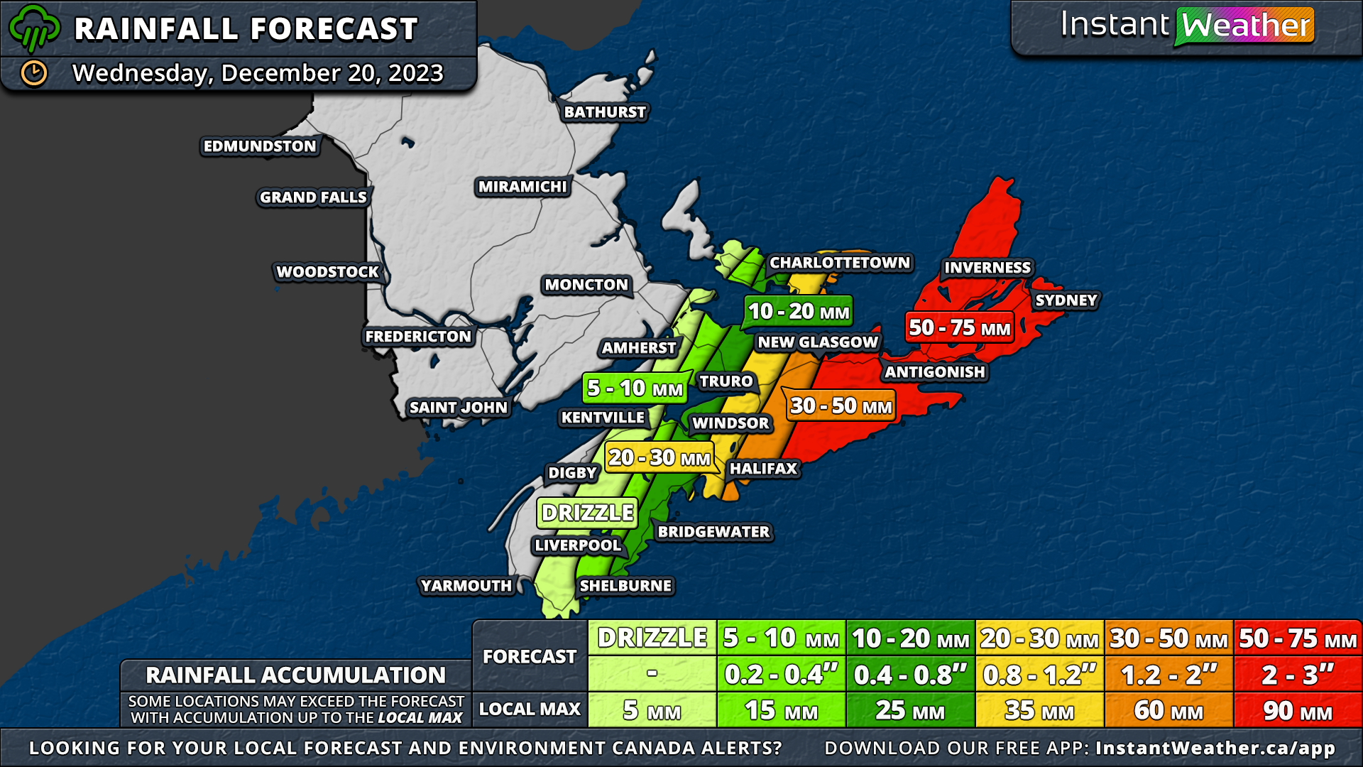
In the meantime, across the Cabot Strait, a rainy start to the week that saw Halifax and east of the city getting hit with 50-100+mm of rain will continue Wednesday when an additional 20-75mm will fall, with the higher amounts further eastward.

Meanwhile, across the Cabot Strait, Halifax and its eastern areas, already drenched with 50-100+mm of rain, anticipate an additional 20-75mm on Wednesday, with the heftier totals expected further east. This mirrors the flood and washout concerns seen in Southern Newfoundland, with up to 75mm of rain forecasted for the Eastern mainland and Cape Breton Island, where rainfall rates could reach 15mm/hr.

New Brunswick is set for a respite from the rain, unlike most of Prince Edward Island. While Prince County might experience minimal rain or drizzle, a stark contrast in Queens and Kings Counties will see drizzle in the west and over 30mm of rain along the eastern coast of Kings County. The rain in PEI, however, will be shorter-lived than in Nova Scotia, concluding Wednesday evening.


GOOGLE AD (NOT ENDORSED BY INSTANT WEATHER)

Nova Scotia on Thursday will see light rain persist overnight. Early Thursday might bring a brief period of freezing rain before it clears from the eastern mainland. Cape Breton Island may also undergo this freezing rain phase, transitioning to light snow that could last throughout the day and into early Friday. A snowfall forecast for this region will be posted on Wednesday evening as well.

Yet Another Strong Rain & Wind Storm Takes Aim at the Maritimes to Start the Week

NOTE: YOU CAN CLICK ON THE MAP TO OPEN A ZOOMABLE IMAGE WHICH WILL BE EASIER TO READ.

This week opens with a familiar scenario: wet and windy conditions as another storm lashes the Maritimes. A low-pressure system travelling up the American coast is set to affect the region from late Sunday through Tuesday.

The storm is expected to deliver rainfall ranging from 10mm to over 100mm, accompanied by wind gusts surpassing 100km/h.


GOOGLE AD (NOT ENDORSED BY INSTANT WEATHER)

The onset of rain in Western New Brunswick late Sunday will mark the storm's arrival, spreading eastward into Nova Scotia and PEI overnight and continuing into Monday morning.

Intensifying by Monday afternoon, rainfall rates are expected to exceed 5mm/hr, reaching up to 10mm/hr in the hardest hit areas. The downpour will gradually diminish overnight, with lingering rain in Eastern Nova Scotia into Tuesday.

Unlike last week's storm, Nova Scotia is on tap for the heaviest rainfall from this system, anticipating over 100mm east of Halifax and isolated areas possibly receiving upwards of 125mm. The Halifax Region is likely to see 75-100mm, while a broad section of the province faces 50-75mm.

Areas like Cumberland County, the Annapolis Valley, Yarmouth and Shelburne Counties, and most of Cape Breton will see around 25-50mm. However, the tip of Inverness and Victoria Counties will see the least, with less than 25mm forecasted. Given the rapid accumulation, localized flooding is a significant concern, particularly in and around Halifax.


GOOGLE AD (NOT ENDORSED BY INSTANT WEATHER)

New Brunswick's rainfall totals will be more modest, with a general expectation of 25-50mm province-wide, including Woodstock, Fredericton, Moncton, and Saint John. Northern and Eastern parts of the province anticipate 10-25mm, spanning from Edmundston to Bathurst and nearly reaching the Chignecto Isthmus.

The highest rainfall totals in the province, between 50-75mm, is predicted for Southwest New Brunswick. PEI's rainfall totals will differ from last week, with lesser amounts in the west and more in the east.

Prince County and western Queens County can expect 10-25mm, while the bulk of Queens County and Kings County are likely to receive 25-50mm.


GOOGLE AD (NOT ENDORSED BY INSTANT WEATHER)

As with last week’s storm, strong wind gusts are anticipated with this storm. New Brunswick can expect gusts up to 95km/h, intensifying to over 100km/h in the south along the Fundy Region.

Prince Edward Island may experience slightly stronger winds than last week, with gusts potentially exceeding 100km/h.

Nova Scotia will encounter similar windy conditions to the previous storm, with widespread gusts of 85-95km/h and up to 110km/h along coastal areas.

The potential for power outages remains high, especially as some trees and branches were weakened by last week's storm.

Currently, models indicate a second system could bring more rain to the region, but are divided on its trajectory. One model suggests additional rainfall over Eastern Nova Scotia, while another predicts the storm will remain well offshore.

Any extra rainfall could exacerbate the already heightened flood risks in the area.

Batten Down the Hatches Maritimes! Very Windy and Wet Day in Store for Monday

NOTE: YOU CAN CLICK ON THE MAP TO OPEN A ZOOMABLE IMAGE WHICH WILL BE EASIER TO READ.

A powerful storm is pushing its way northward along the American East Coast and the leading edge has already started to push into the Maritimes with rain beginning to fall in New Brunswick.

While rain is expected to some degree across the entire region, New Brunswick will see the bulk of it, with some areas looking at up to 75mm by the end of the day tomorrow.


GOOGLE AD (NOT ENDORSED BY INSTANT WEATHER)

The rain will be light to start, before increasing in intensity overnight and remaining steady throughout the day and rainfall rates may exceed 5mm/hr at times during the morning.

In the Northwest Region, cooler temperatures will result in most of the precipitation to fall as snow, meaning that instead of 50-75mm of rain, this area is looking at upwards of 30cm of snow.

Beyond New Brunswick, precipitation becomes less of an issue for most of the rest of the Maritimes. Nova Scotia and PEI can expect 5-20mm of rain, with the exception of Prince County where 20-50mm of rain is possible.


GOOGLE AD (NOT ENDORSED BY INSTANT WEATHER)

As the centre of the storm approaches and crosses through the Maritimes on Monday, the winds will begin to ramp up, peaking in the early afternoon. The strongest wind gusts will be over 100km/h for coastal areas in Southern New Brunswick and across Western and Central Nova Scotia.

These strong gusts will penetrate quite far inland meaning the rest of Nova Scotia, most of Central and Southern New Brunswick and the entirety of PEI can expect wind gusts over 80km/h. These strong winds will very likely result in widespread power outages across the entire region.

Winter Storm to Impact Atlantic Canada With Up to 20cm of Snow Beginning Sunday Night

NOTE: YOU CAN CLICK ON THE MAP TO OPEN A ZOOMABLE IMAGE WHICH WILL BE EASIER TO READ.

After a rather rainy start to the season in Atlantic Canada, a significant change is on the horizon with widespread snowfall anticipated overnight tonight.


GOOGLE AD (NOT ENDORSED BY INSTANT WEATHER)

Southern New Brunswick and much of Central Nova Scotia are expected to experience snowfall in the 15-20cm range from Sunday night through Tuesday.

While localized patches could see amounts exceeding 20cm, the Atlantic coast of Nova Scotia will likely have limited snowfall due to above-freezing temperatures, resulting in some or all of the precipitation falling as rain.

The low-pressure system driving this weather shift has already begun its movement into the region, bringing light rain and snow to Southern Nova Scotia. As it progresses closer, the snow will extend north and eastward, covering the entire province and reaching into New Brunswick and Prince Edward Island.


GOOGLE AD (NOT ENDORSED BY INSTANT WEATHER)

By early Monday afternoon, the snow will gradually taper off from west to east, and the storm is expected to exit the region by late evening. Some light flurries may linger overnight Monday into Tuesday afternoon, contributing an additional couple of centimetres of snow.

Since the low-pressure centre will track to the south of Nova Scotia, the expected snowfall totals begin to decrease in Northern New Brunswick.