BREAKING: Environment Canada Forecasting Possible Significant Freezing Rain for Parts of Ontario
/
NOTE: CLICK OR TAP THE IMAGE TO OPEN AN IMAGE YOU CAN ZOOM
Environment Canada is monitoring a deep low-pressure system expected to affect Ontario late Sunday through Monday. While details remain uncertain this early on, a “significant, prolonged period of freezing rain event” is possible as per Environment Canada’s meteorologists. In addition to the freezing rain, heavy snow, and strong winds are possible in parts of the province. Surfaces like roads, sidewalks, and trees may become dangerously icy, and widespread power outages are possible if this continues to trend strong.
NOTE: CLICK OR TAP THE IMAGE TO OPEN AN IMAGE YOU CAN ZOOM
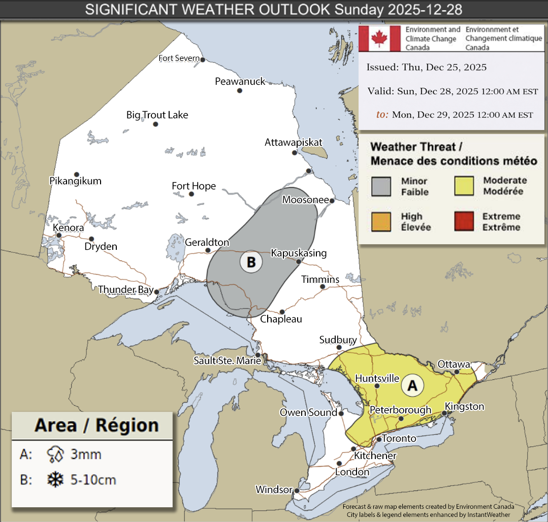
Sunday, December 28th:
Location A (Ice, 3mm): A potential freezing rain event could glaze roads and walkways across eastern and central Ontario and parts of the Greater Golden Horseshoe. Confidence remains low regarding exact timing, precipitation type, and coverage.
Location B (Snow, 5–10cm): Northeastern Ontario may see 5 to 10 cm of snow, leading to difficult travel conditions and reduced visibility. Snowfall amounts and affected areas remain uncertain this early on.

NOTE: CLICK OR TAP THE IMAGE TO OPEN AN IMAGE YOU CAN ZOOM
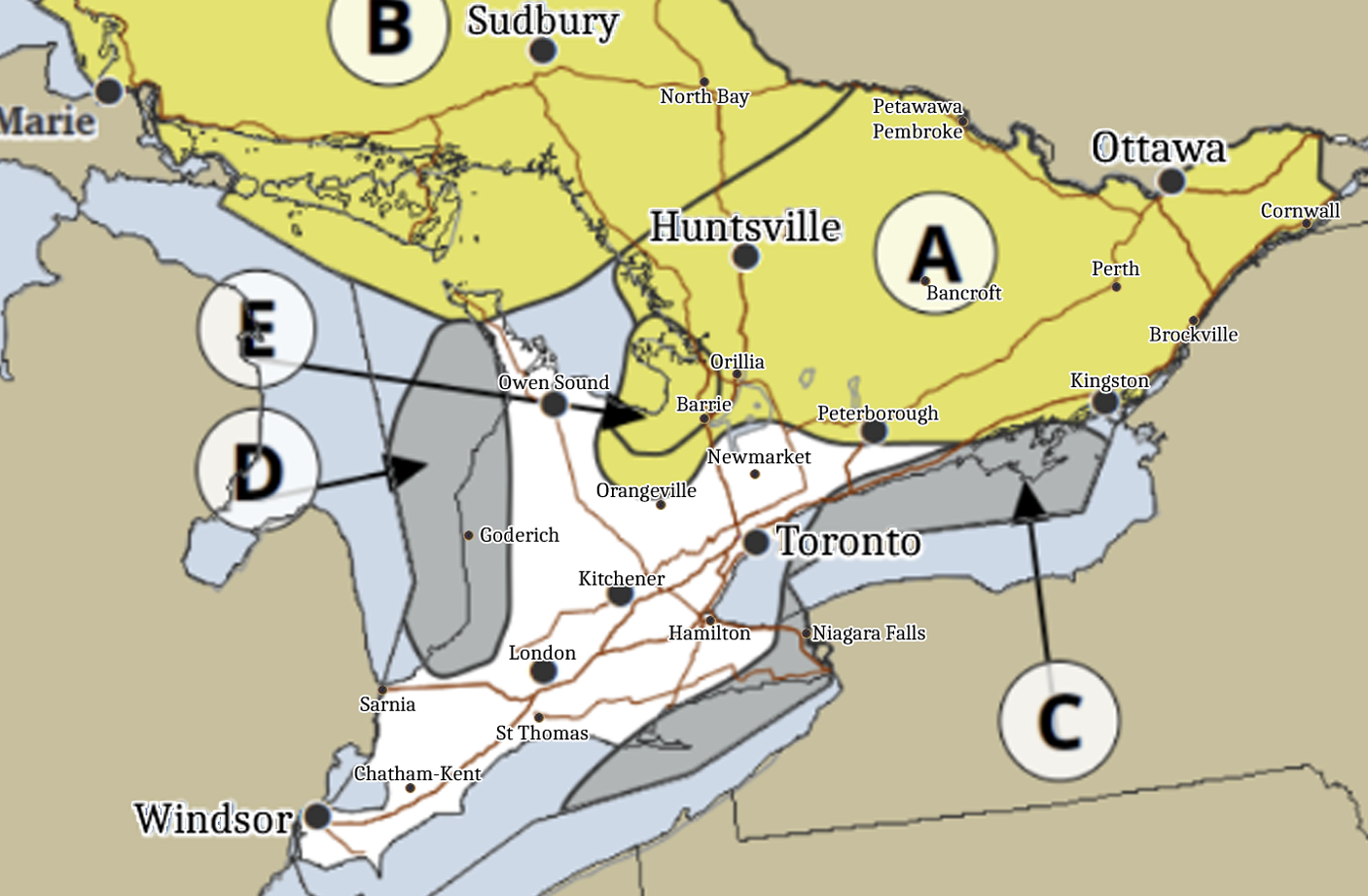
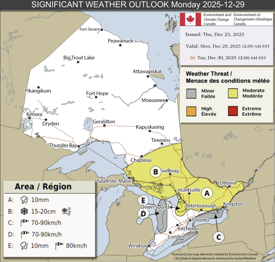
Monday, December 29th:
Location A (Ice, 10mm+): A strong and deep low could produce significant, prolonged freezing rain across eastern and central Ontario, with ice accretion on trees and power lines leading to branch breakage and power outages.
Location B (Snow & Blowing Snow, 15–20 cm): Portions of northeastern and central Ontario may receive 15–20 cm of snow with blowing snow and gusts up to 70 km/h, causing difficult travel and reduced visibility.
Locations C & D (Wind, 70–90 km/h): Westerly or northwesterly wind gusts of 70–90 km/h are possible along the eastern shores of Lake Huron, northeastern shores of Lake Ontario, and Lake Erie, potentially tossing loose objects and causing power outages.
Location E (Ice & Wind, 10 mm & 80 km/h): Southeast of Georgian Bay may experience a combination of prolonged freezing rain and wind gusts up to 80–90 km/h, resulting in ice build-up and possible significant impacts. Confidence remains moderate to low for precipitation type, amounts, and exact areas but we’ll continue to monitor this carefully over the next few days to see how it progresses.
NOTE: CLICK OR TAP THE IMAGE TO OPEN AN IMAGE YOU CAN ZOOM

NOTE: CLICK OR TAP THE IMAGE TO OPEN AN IMAGE YOU CAN ZOOM
In summary:
The exact details of this event continue to unfold and there is potential for this to change. However, there is quite a bit of agreement on the models at this time regarding the prolonged freezing event with strong wind gusts. Please be prepared for slippery roads, reduced visibility and potential power outages and now would be a good time to begin reviewing your travel plans if you plan to travel on Sunday or Monday. More details ASAP.


