Poorly Timed Alberta Clipper to Bring Up to 10-20cm of Snow to Southern Ontario Ahead of Wednesday Morning Commute
/
NOTE: YOU CAN CLICK ON THE MAP TO OPEN A ZOOMABLE IMAGE

As we enter the final days of February, it appears the month is set to go out like a lion across Southern Ontario. A poorly timed Alberta clipper is expected to sweep through the region overnight Tuesday into Wednesday, bringing a widespread snowfall and a return to more wintry conditions just as many were starting to get used to some slightly milder weather.
While total accumulation with this system is not expected to be overly significant by late February standards, with general widespread amounts of 5 to 10 cm and some localized pockets closer to 15 cm, what makes this event potentially impactful is the timing and how it lines up with the Wednesday morning commute.
The bulk of this snow is forecast to fall during the overnight hours, lasting into early Wednesday morning. That means many roads will be snow-covered with very little time for crews to fully clear and treat surfaces before traffic begins to build.
Even though snowfall rates are not expected to be extreme, the steady nature of the snow will allow it to accumulate on untreated roads, potentially resulting in slow travel, slippery conditions and even some school bus cancellations in areas where backroads remain snow-covered.
Wind gusts approaching 40 to 60 km/h throughout the morning hours could further reduce visibility due to blowing snow, especially in more exposed areas such as regions east of Lake Huron and around Georgian Bay. Even if the snowfall itself is light to moderate, the added wind will make it feel more intense at times and could create brief periods of near whiteout conditions in open stretches of highway and rural roads.
The system snow is expected to wrap up by the late morning hours as the clipper exits our region to the east. However, that will not necessarily mark the end of the story. Behind the system, a surge of colder Arctic air is forecast to move in, briefly reawakening Lake Huron and Georgian Bay. Ice coverage on both lakes has decreased somewhat over the past few weeks, thanks to temperatures running above seasonal norms, and that open water may allow for renewed lake effect snow development.
As the colder air flows over the relatively milder lake waters, some localized pockets of heavier lake effect snow could develop throughout the day on Wednesday. There is still some uncertainty regarding the exact intensity of this activity, particularly given the remaining ice coverage, which can limit how much moisture the bands are able to tap into. In addition, wind direction is expected to shift throughout the day, making it difficult for any one band to lock in over a single community for an extended period of time.
If the lake effect does organize, it could bring an additional 5 to 10 cm of snow on top of the 5 to 10 cm from the clipper system. That means some areas east of Lake Huron and Georgian Bay could be looking at a combined total of 10 to 20 cm by the end of the day Wednesday, especially in communities that see multiple rounds of heavier bursts.
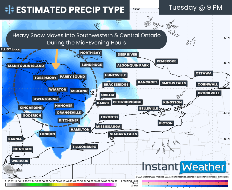
PRECIP TYPE - MAP FROM WEATHERBELL
Current indications suggest the initial bands of heavier snow associated with the clipper should move into regions around Lake Huron and Georgian Bay sometime during the mid to late evening hours on Tuesday. It looks to be heaviest around Grey and Bruce counties at first, before slowly expanding eastward through the rest of the evening and into Central Ontario.
Wind gusts will also be increasing through the evening, leading to blowing snow and reduced visibility overnight. Travel could become fairly difficult, particularly in rural areas and on secondary highways, as the heavier snow moves through during the late evening and overnight hours.
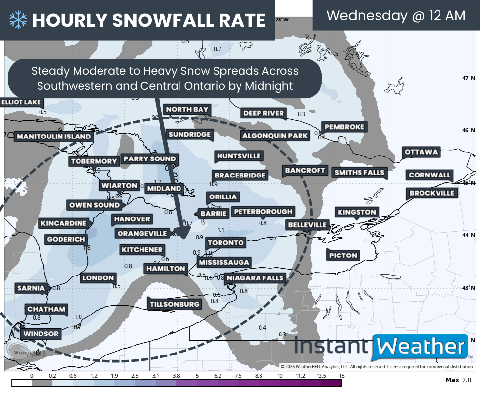
Hourly snowfall rates (cm) - MAP FROM WEATHERBELL
By around midnight, most of Southwestern and Central Ontario should be seeing widespread steady snowfall, with the snow stretching into the Greater Toronto Area as well. The GTA is not expected to see the heaviest bands, but steady snow through the overnight hours will still be enough to create snow-covered roads by daybreak.
This snow will not be particularly intense, with hourly snowfall rates generally near or slightly below 1 cm per hour. However, when that steady snowfall persists for several hours overnight, those hourly amounts can add up quickly. A consistent light to moderate snowfall over a 4 to 6-hour window is more than enough to create slick travel conditions by morning.
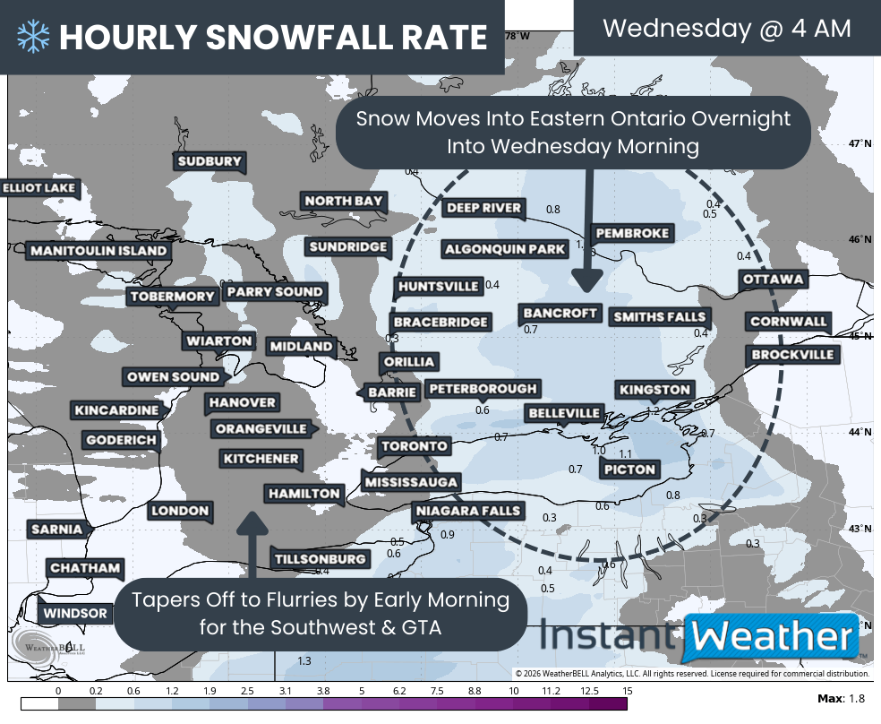
Hourly snowfall rates (cm) - MAP FROM WEATHERBELL
Once the snow begins in any given area, it should last for roughly 4 to 6 hours before tapering off. In Southwestern Ontario and the Golden Horseshoe, snowfall should come to an end by the mid-morning hours on Wednesday, while areas farther east will see snow lingering a bit longer.
This is also when the snow will begin to push into Eastern Ontario, setting up for ongoing snowfall right at the height of the morning commute in that region. That timing could lead to more noticeable impacts for communities along the St Lawrence River and into the Ottawa Valley, where snow may still be falling steadily as people head to work and school.
Aside from Eastern Ontario, the snow should be mostly done by sunrise across much of Southern Ontario. However, even if flakes are no longer falling, road conditions may still be less than ideal. With snow ending around 3 to 5 AM in many areas, that leaves a narrow window for cleanup operations, especially in regions with extensive rural road networks and less traffic to help pack down and melt the snow.
The exact impacts will vary depending on location. In more urban areas such as the Greater Toronto Area, cleanup on major highways and primary roads should occur relatively quickly, meaning the morning commute will likely be slower than usual but still manageable. In more rural communities, continued blowing snow combined with existing overnight accumulation could be enough to lead to significant travel delays and the possibility of school bus cancellations.
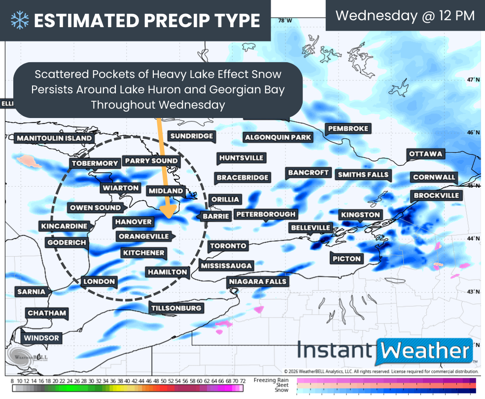
PRECIP TYPE - MAP FROM WEATHERBELL
Another factor we will be closely watching is the development of scattered lake effect snow bands by the late morning hours on Wednesday, continuing into the afternoon and evening. These bands appear most likely to focus on areas east of Lake Huron and Georgian Bay, but shifting winds could occasionally push bursts of heavier snow into neighbouring regions.
Because both Lake Huron and Georgian Bay remain partially ice-covered, the available moisture for lake effect development is somewhat limited. That should help prevent the bands from becoming extremely intense or long-lasting. Changing wind direction throughout Wednesday will also reduce the likelihood of a single band sitting over one community for many hours.
That said, wherever a lake effect band does set up, conditions can deteriorate quickly. Heavy snowfall rates and sharply reduced visibility are possible in these localized areas.
There are some indications that northern portions of Grey and Bruce counties could see more persistent lake effect activity later Wednesday and into the early overnight hours. If that scenario materializes, slightly higher totals would be possible in those areas, particularly along the Bruce Peninsula.

NOTE: YOU CAN CLICK ON THE MAP TO OPEN A ZOOMABLE IMAGE

Looking strictly at the snowfall totals from the clipper itself, most of Southern Ontario is expected to see around 5 to 10 cm by the time it tapers off Wednesday morning. A few localized spots could approach 15 cm if they happen to sit under a heavier band for a longer period, but those higher totals will be the exception rather than the rule.
Adding in the lake effect component, another 5 to 10 cm is possible through the day on Wednesday for areas east of Lake Huron and Georgian Bay. That would bring combined totals into the 10 to 20 cm range for communities such as Goderich, Kincardine, Hanover, Owen Sound, Wiarton, Tobermory, Midland, Orillia, Bracebridge and Parry Sound.
Lower snowfall totals under 5 cm are expected for Deep Southwestern Ontario, parts of the Niagara region and along the St Lawrence River in Eastern Ontario. The latest data suggests the system will carry less moisture into these areas, and some locations may briefly sit in a dry slot, resulting in lighter and more intermittent snowfall. Even so, localized amounts closer to 8 cm cannot be ruled out where steadier snow manages to develop for a few hours.
Overall, while this Alberta clipper is not shaping up to be a blockbuster winter storm, its overnight timing, steady snowfall and gusty winds will likely be enough to cause headaches for the Wednesday morning commute across parts of Southern Ontario.


