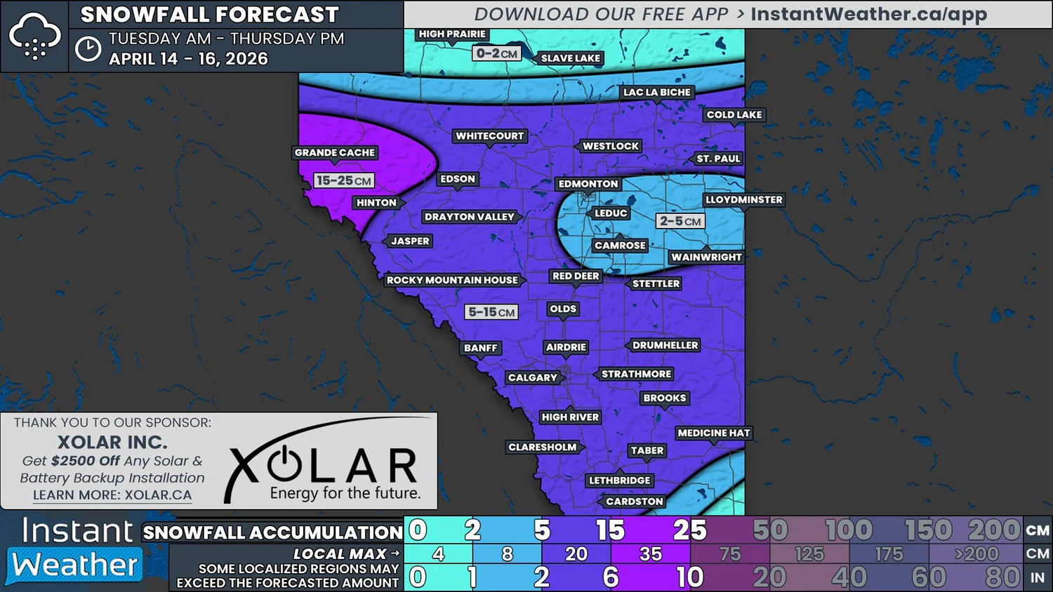
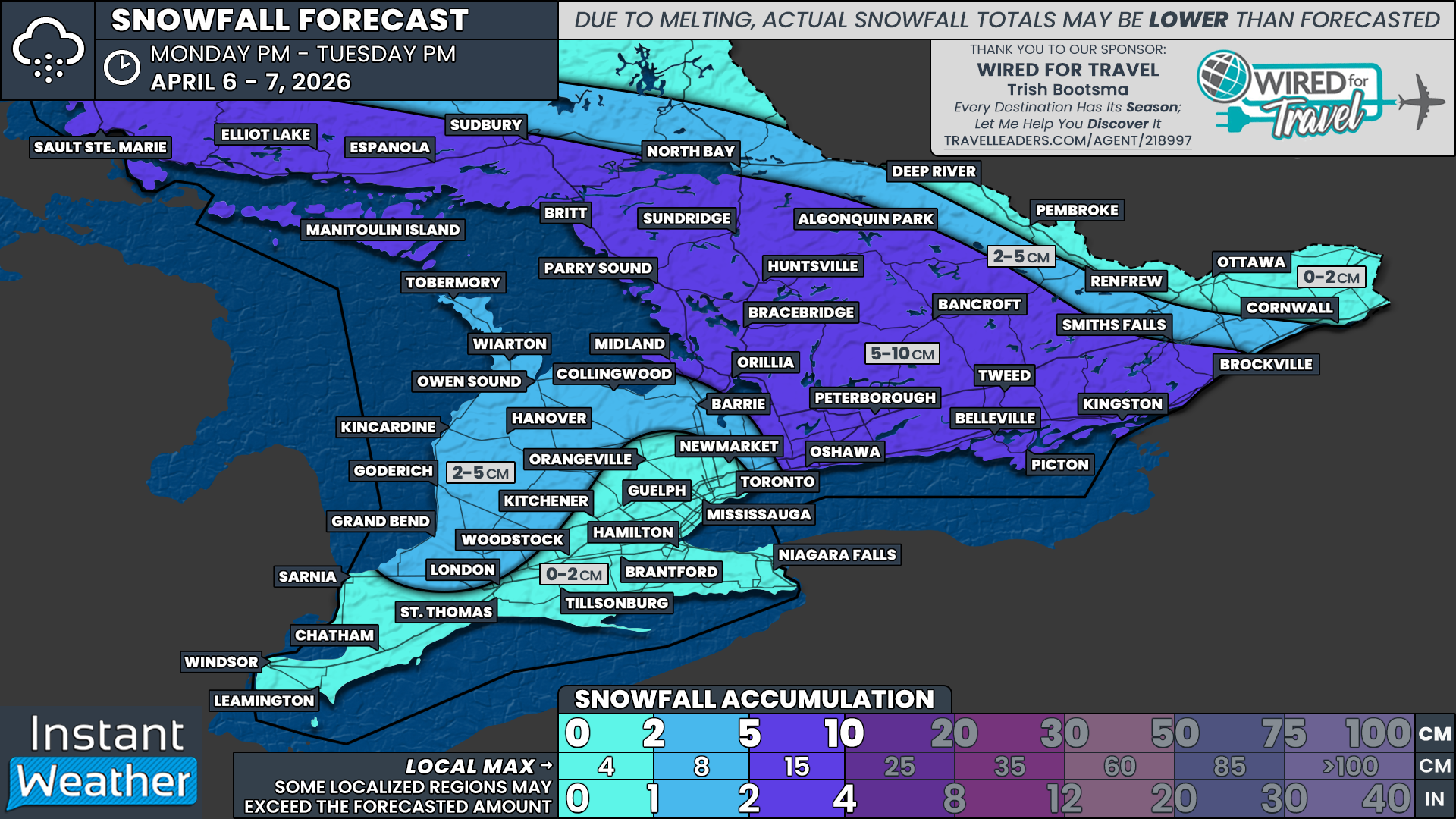
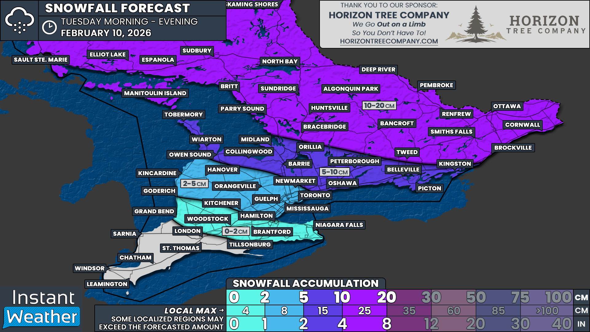
Buckle Up: Parts of Saskatchewan & Manitoba About to Get Hammered By an Intense Spring Storm This Week
/
NOTE: YOU CAN CLICK ON THE MAP TO OPEN A ZOOMABLE IMAGE
We may be in the latter half of April, but winter is still hanging on across the Prairies. On Wednesday, a massive low pressure system will begin to develop which will bring chaos to Saskatchewan and Manitoba over the next few days.
Unfortunately, we’re looking at all precipitation types in both provinces, with some places possibly expecting full-on blizzard conditions, while others could see temperatures in the 20s and severe thunderstorms. This makes for a very complicated forecast, but we’ll do our best to break it down for you here.
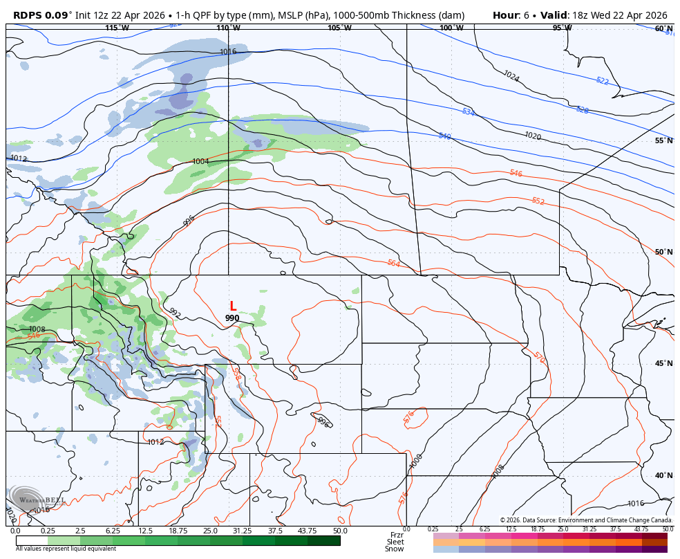
The rdps model showing precipitation type and intensity at 12pm cst/1pm CT on Wednesday, courtesy of WeatherBell.
The rdps model showing precipitation type and intensity at 7pm cst/8pm CT on Wednesday, courtesy of WeatherBell.
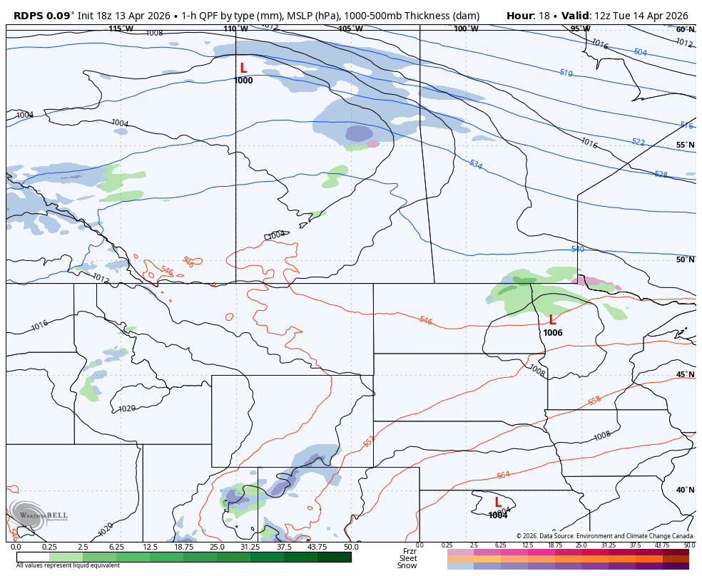
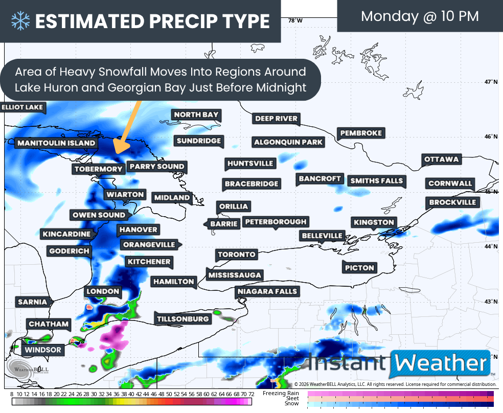
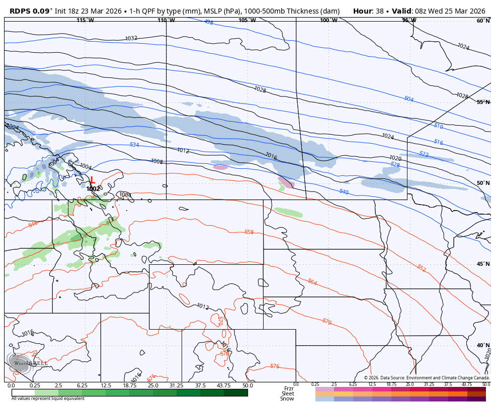
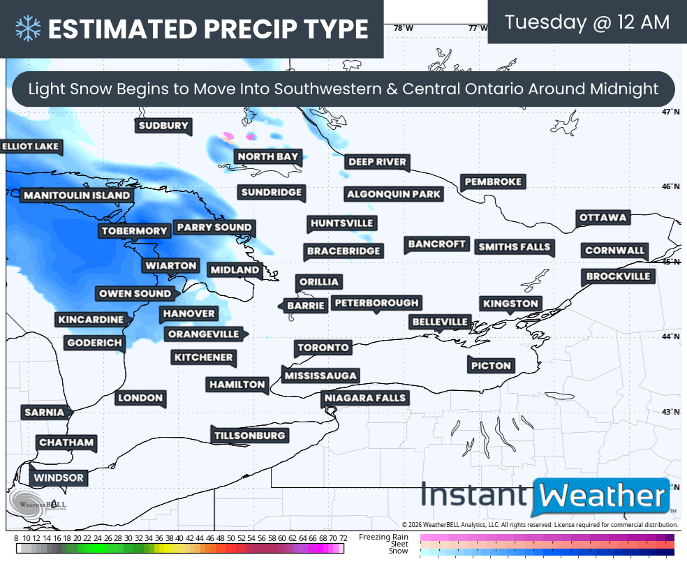
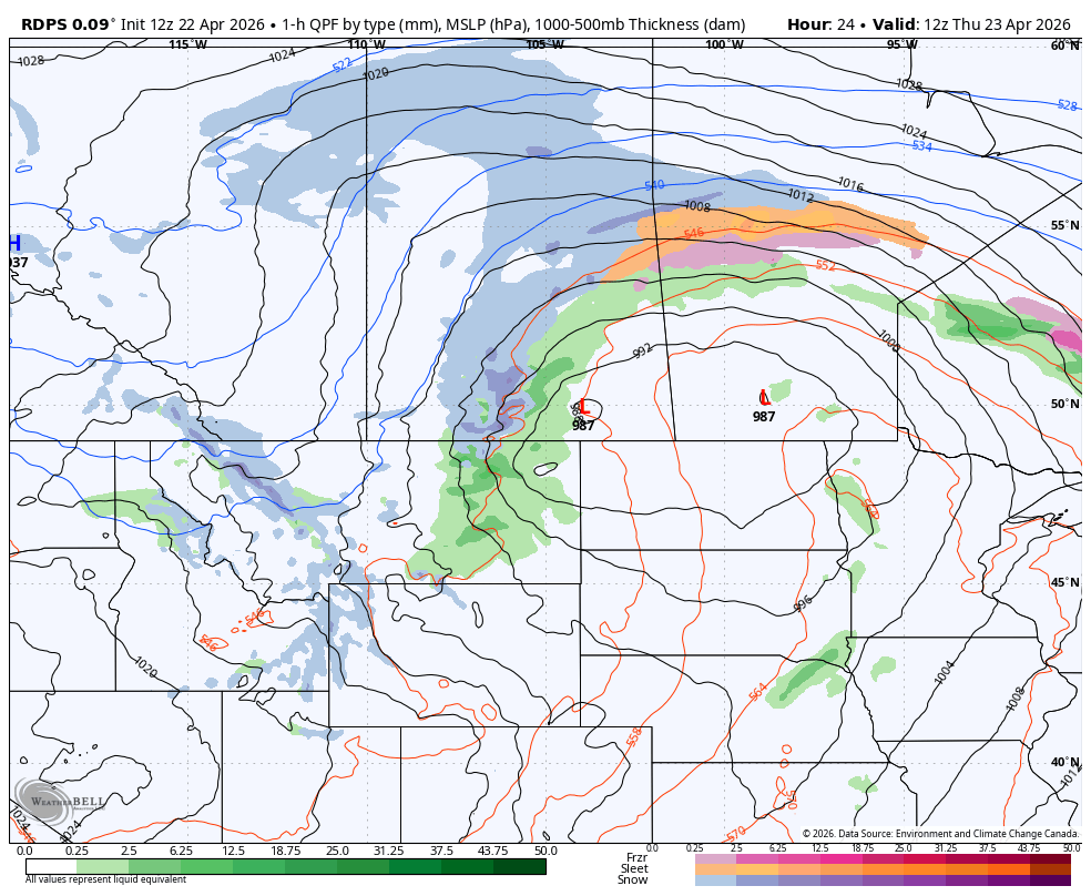
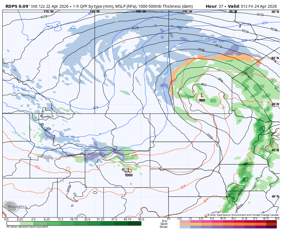
An area of light to moderate rainfall began to move into Northern Saskatchewan from Alberta on Wednesday morning, which then started to transition to snow before the lunch hour.
Through the afternoon and into the evening, the area of snowfall will expand and spread eastward as the low strengthens and becomes more organized. Meanwhile, the trailing rainfall will make its way into Central and Southern Saskatchewan.
The snowfall will be fairly light at first, but there is expected to be some pockets of more moderate snowfall during the evening. However, things will really start to ramp up as we get later in the evening and continuing into the overnight hours, just as the leading edge of the storm will start to cross into Northern Manitoba.
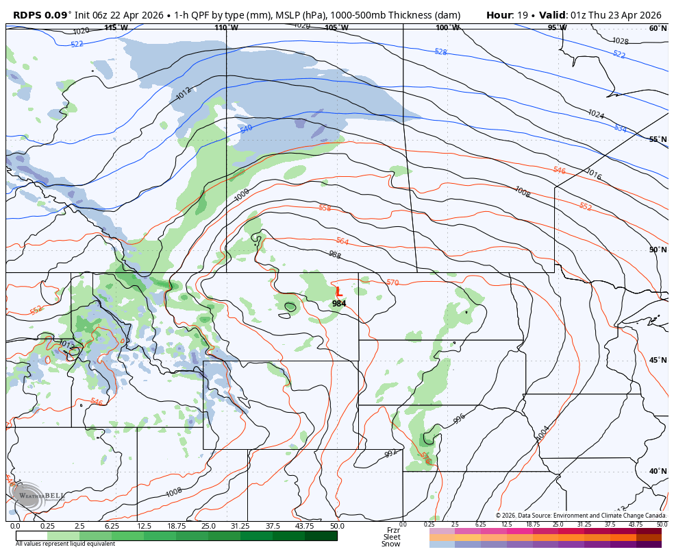
The rdps model showing precipitation type and intensity at 12am cst/1am CT on Thursday, courtesy of WeatherBell.
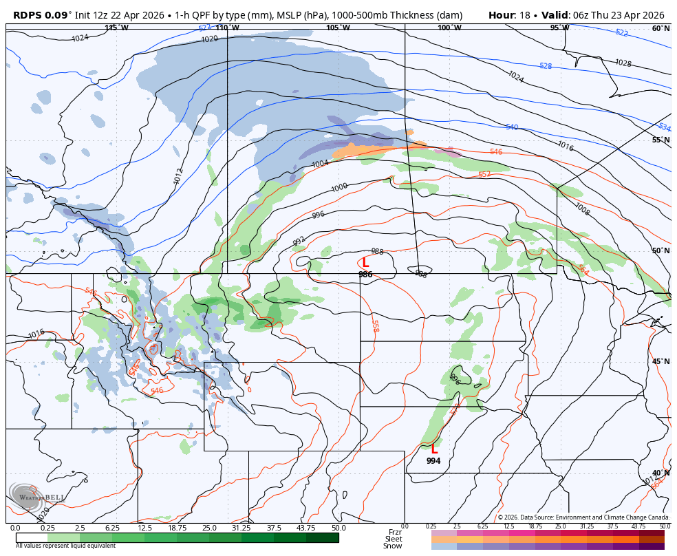
The rdps model showing precipitation type and intensity at 6am cst/7Am CT on Thursday, courtesy of WeatherBell.
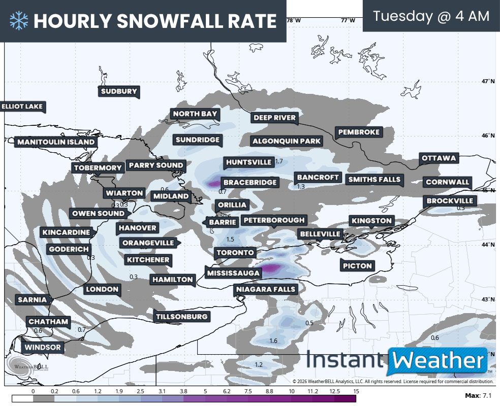
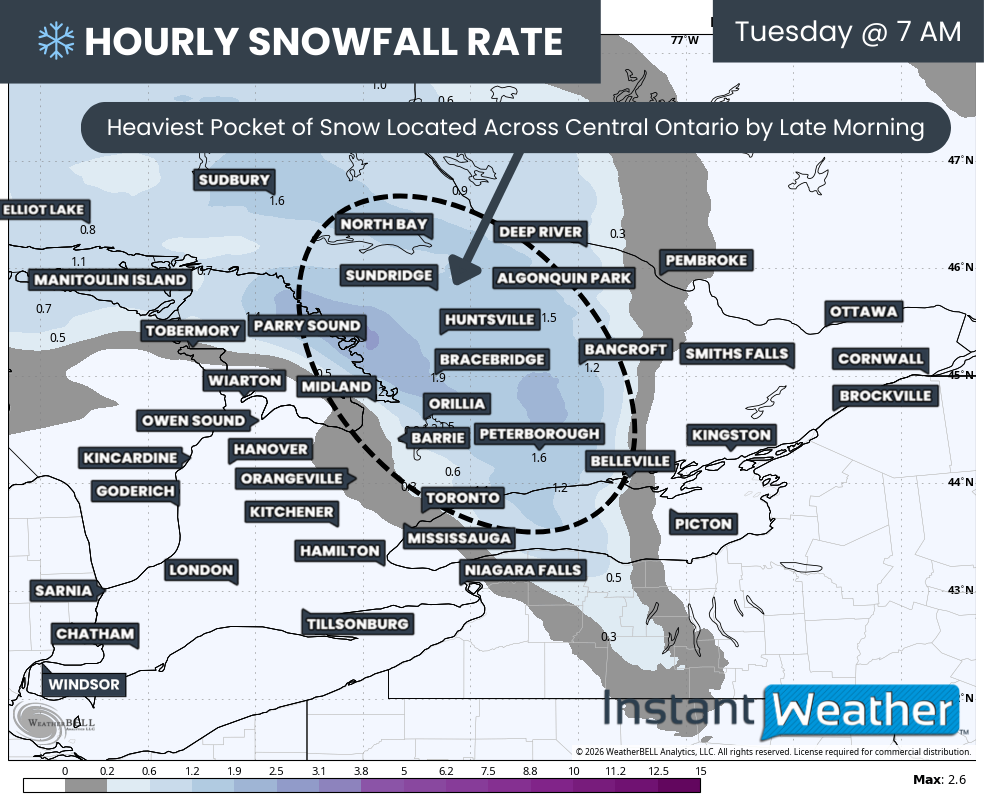
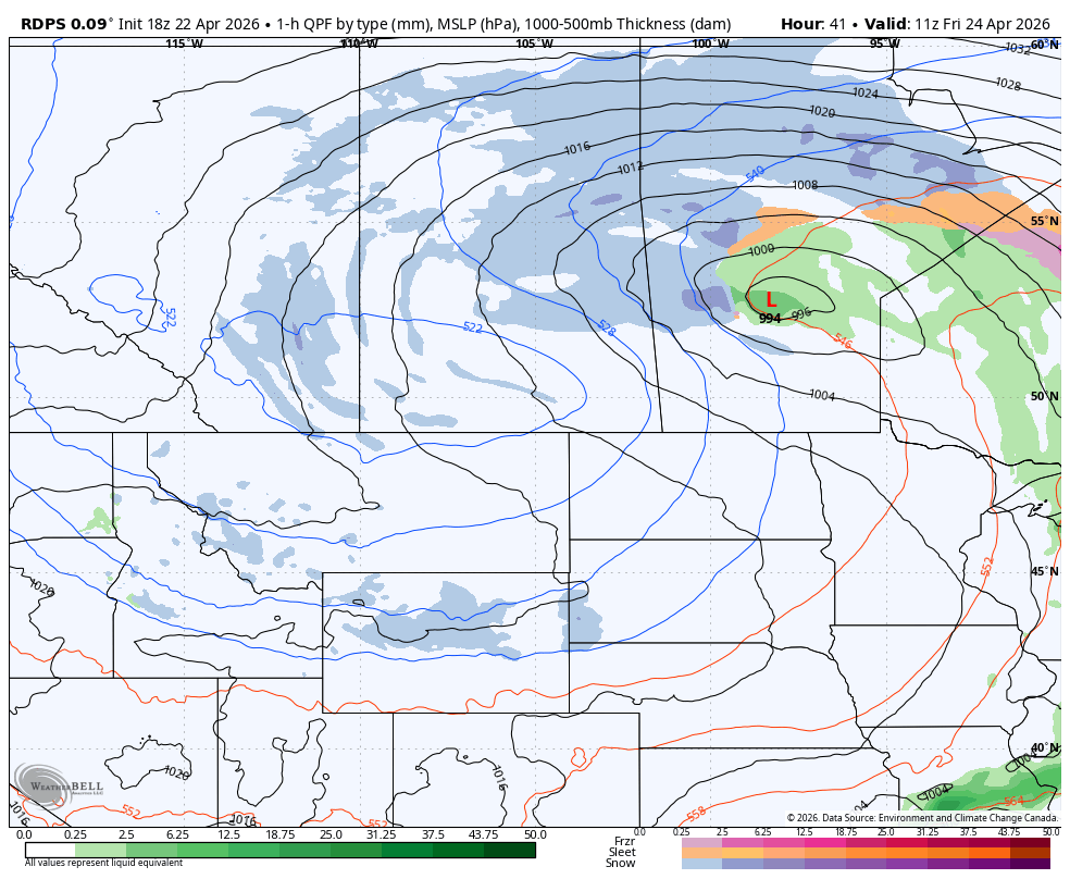
This is when the heaviest snow will start to develop, falling at a rate of up to 3cm/hr, and it is expected to persist well into the afternoon across a significant swath of Northern Saskatchewan.
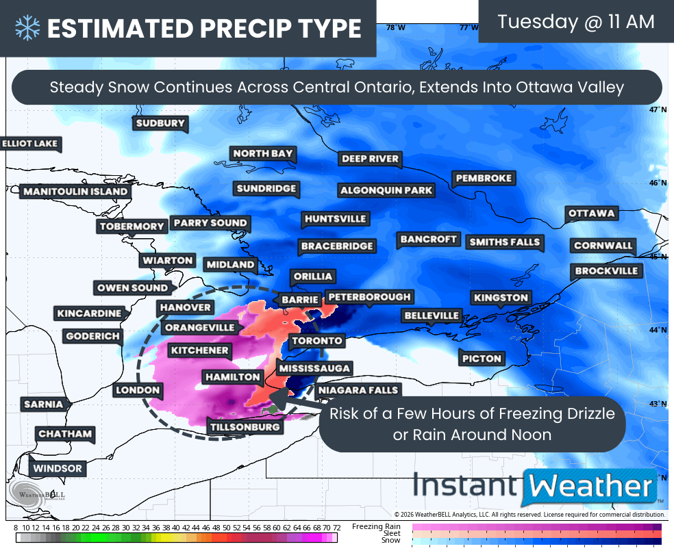
Meanwhile, the heavy rain that is expected to track through West Central and Southwest Saskatchewan overnight Wednesday will start to transition over to snow Thursday morning, as cold air from the Arctic is pulled in around the backside of the system. A quick 5-15cm of snow will be dumped over much of this region by the late afternoon/early evening, at which time this area of snowfall will begin to dissipate.
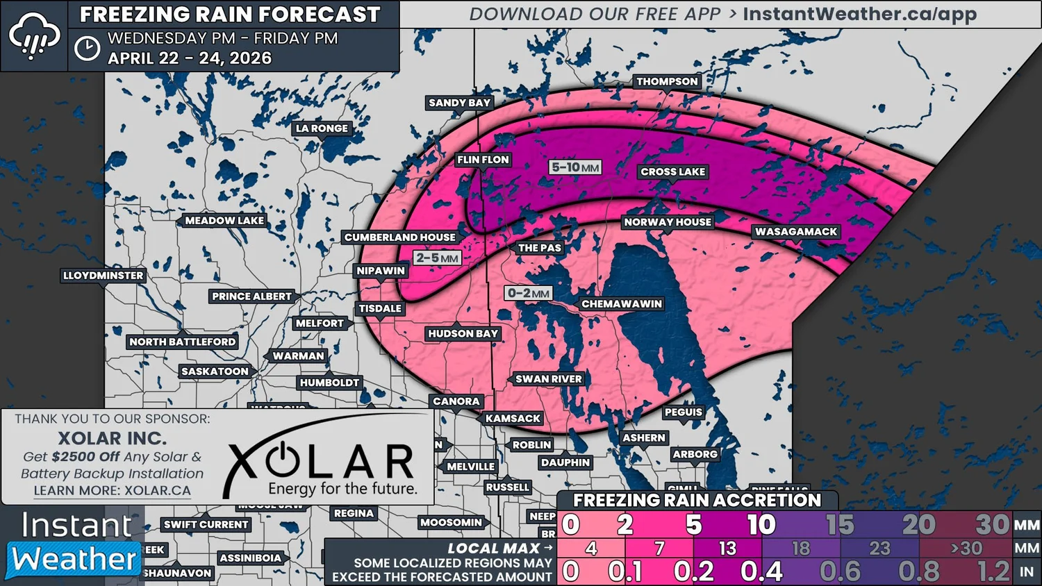
Also during the early morning hours, freezing rain and ice pellets will be added to the mixture of rain and snow in Northeastern Saskatchewan and into Northern Manitoba. The freezing rain could be quite heavy at times across a fairly narrow path that stretches from approximately Cumberland House and Flin Flon to the Ontario border.
Ice accretions above 5mm, and even as high as 10mm, are possible by the early afternoon Thursday, which has prompted Environment Canada to issue Winter Storm and Freezing Rain Warnings alongside the Snowfall Warnings. This is a significant amount of ice buildup that will likely damage both trees and powerlines and could lead to prolonged power outages for the area, so be prepared.
NOTE: YOU CAN CLICK ON THE MAP TO OPEN A ZOOMABLE IMAGE
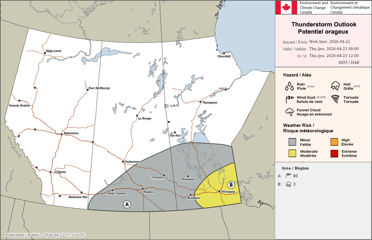
Environment Canada Thunderstorm Lookout Map for Thursday morning
The situation across Southern Manitoba and into the Southeast corner of Saskatchewan will be remarkably different. Late Wednesday evening and into the early morning hours of Thursday, there will be the risk of some elevated thunderstorms, particularly to the east of Brandon, that could have the potential to produce up to Toonie-sized hail.
Temperatures will then climb into the upper teens and low 20s in the afternoon in this region before the cold front slides through during the late afternoon and evening. This will trigger development of additional, marginally severe thunderstorms from Winnipeg eastward.
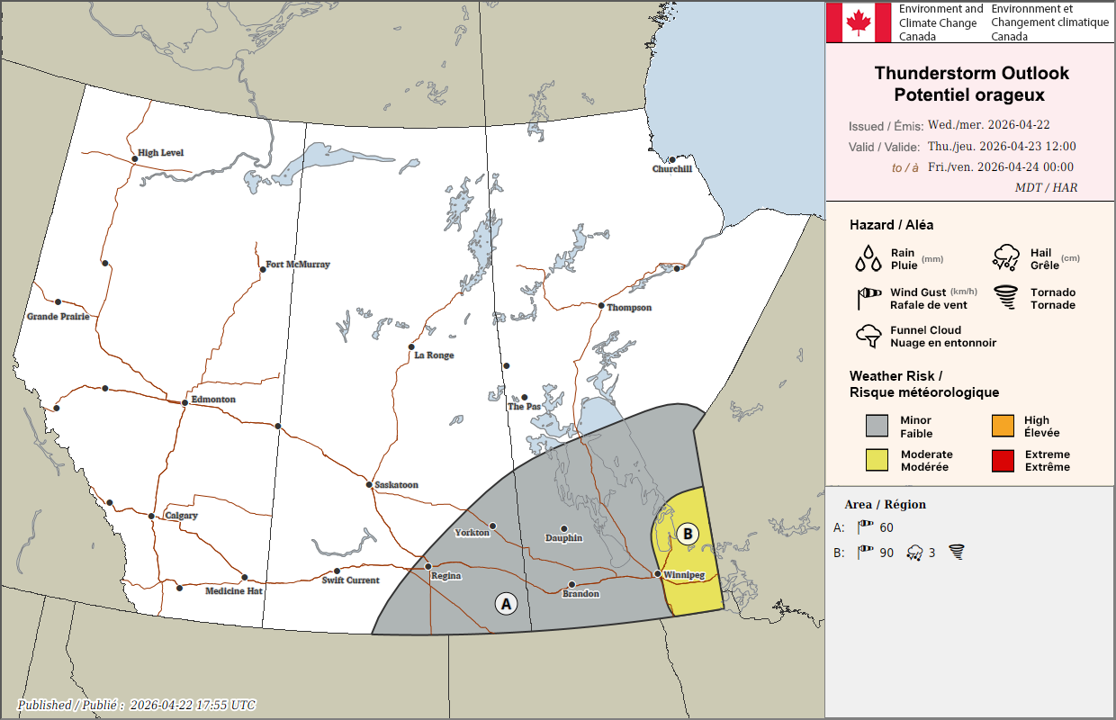
Environment Canada Thunderstorm Lookout Map for Thursday Afternoon and evening
The thunderstorms will likely form in lines, but an individual supercell or two could be possible. These storms may produce strong wind gusts up to 90km/h, Toonie-sized, and the possibility of a tornado can not be ruled out.
As of Wednesday afternoon, this thunderstorm development is conditional on a few factors so if, when, and where they might occur could change. We will definitely be watching the situation closely.
Outside of this area, to the north and west, there is a lesser risk from thunderstorms throughout the day, with strong wind gusts being the main concern. We will go into more detail about the wind later in the forecast.
The rdps model showing precipitation type and intensity at 7pm cst/8pm CT on Thursday, courtesy of WeatherBell.
The rdps model showing precipitation type and intensity at 5Am cst/6Am CT on Friday, courtesy of WeatherBell.
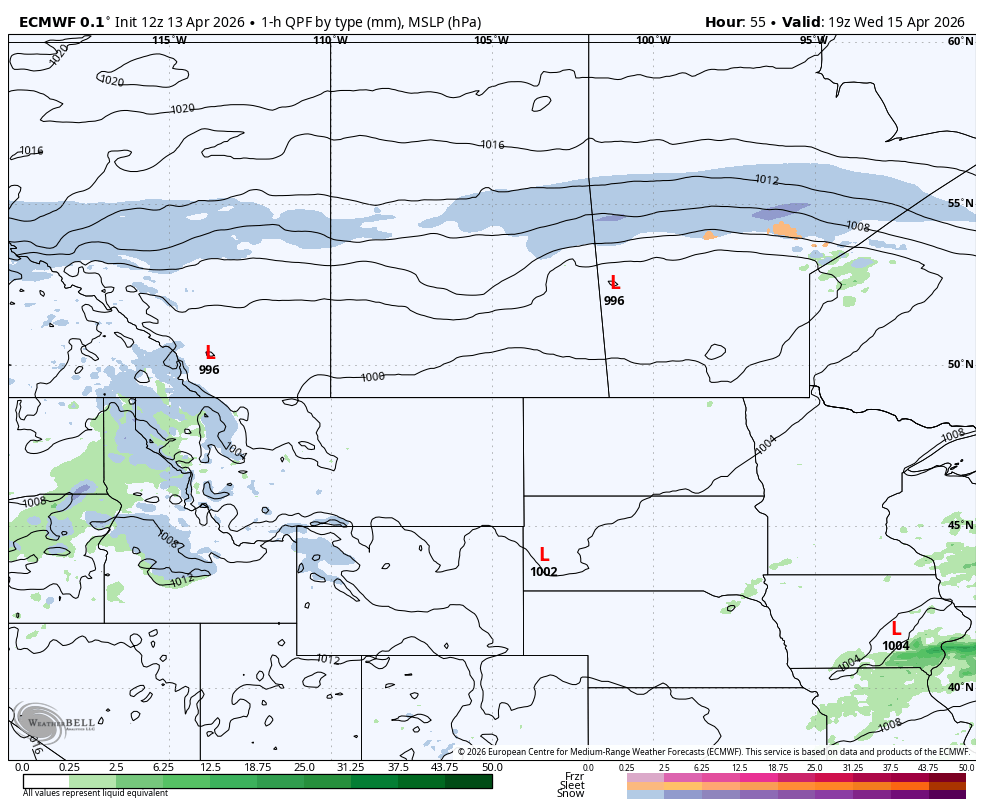
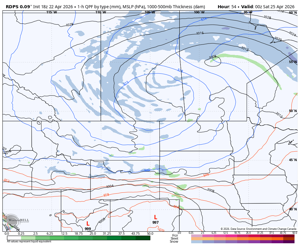
As we get into Thursday evening, the system begins to lose some organization in Saskatchewan, while the heavier snow sets up in Northern Manitoba.
Overnight, the low will start to track northward and it will continue along with path through the day Friday. During this time, there is a possibility of brief freezing drizzle in Central Manitoba, but very little ice would build up.
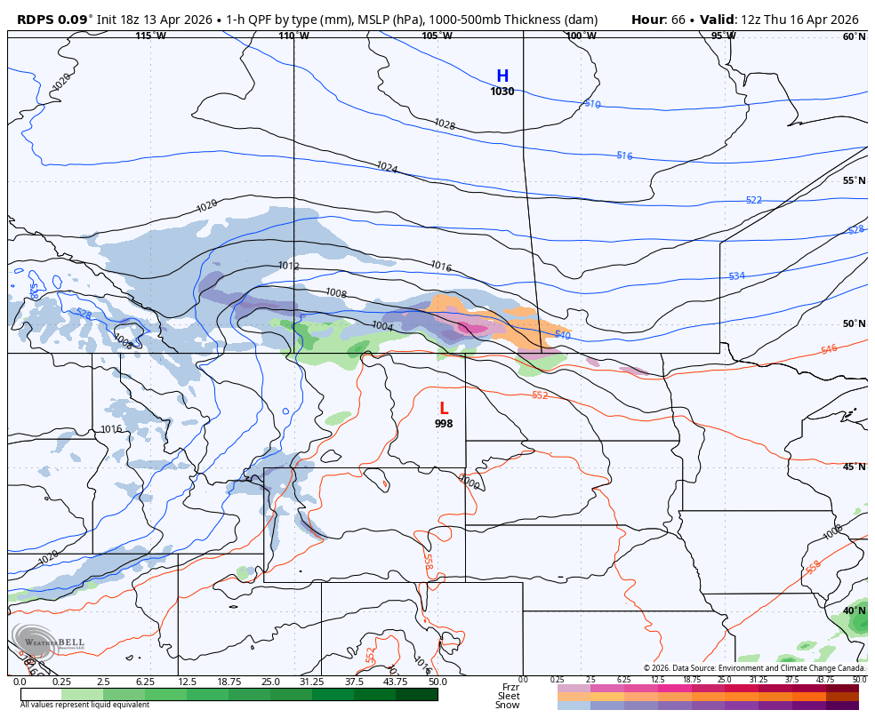
The heavy snow will continue to fall in Northern Manitoba into the afternoon, while large areas of lighter snow will wrap around the low and settle over Saskatchewan for the majority of the day.
By Friday evening, the entire system will start to fall apart and the snow will taper off overnight. A few flurries will linger through Saturday morning, which may add a centimetre or two to the total accumulations across both Saskatchewan and Manitoba.
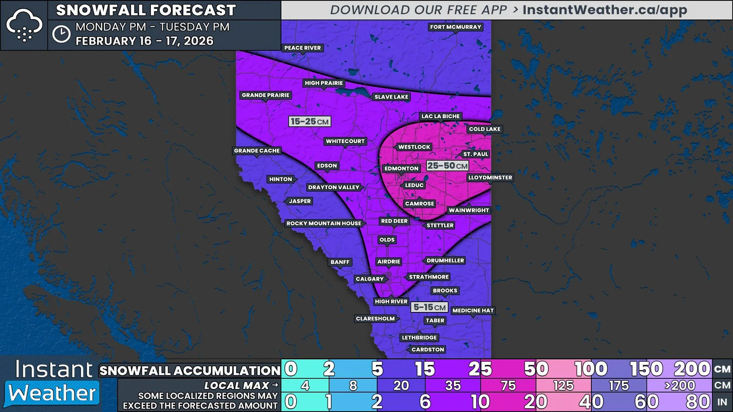
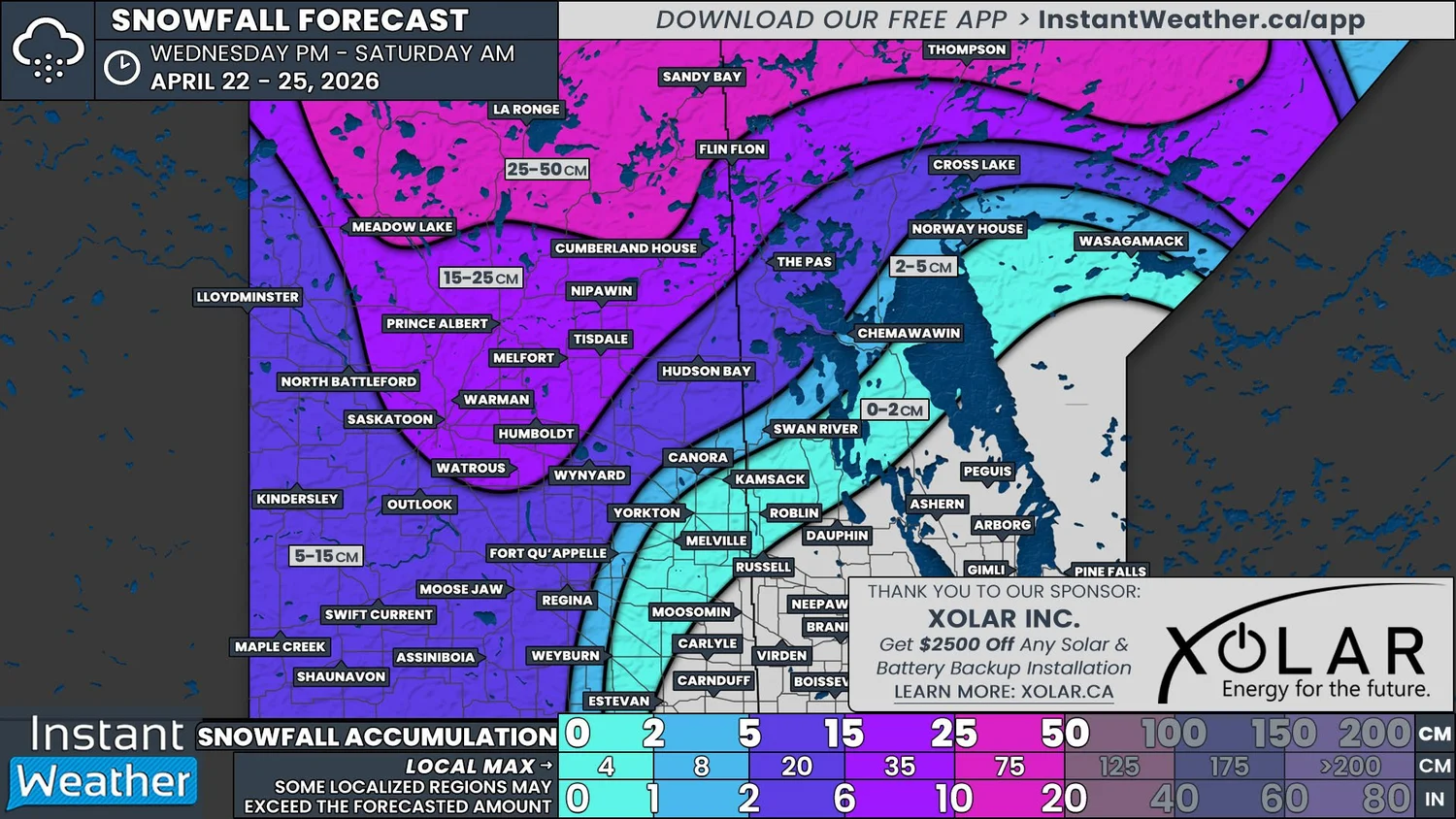
By the time the storm has finished, a total of 25-50cm of fresh snow is expected to fall across a large stretch of Northern Saskatchewan and Manitoba. An area of 15-25cm will extend southward into Central Saskatchewan while most of the rest of the province will be in the 5-15cm range.
Heavy rain is also a concern for areas to the south of the heaviest snowfall. Rainfall totals approaching 30mm could lead to some localized flooding, especially in areas where the ground is still partially frozen.
The rdps model showing precipitation type and intensity at 6pm cst/7pm CT on Friday, courtesy of WeatherBell.
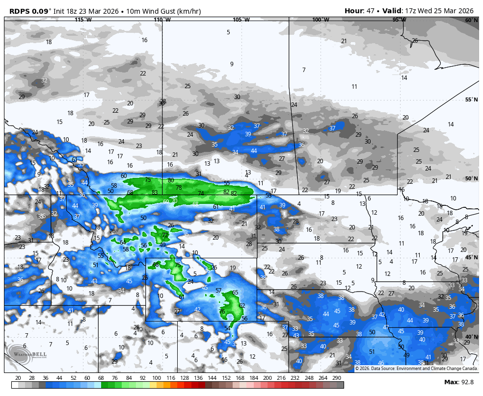
Precipitation will not be the only hazard this storm brings; strong wind gusts will also be a concern.
Strong wind gusts up to 90km/h, and possibly up to 100km/h in the Cypress Hills area, will develop this evening in Southeastern Alberta and Southwest Saskatchewan. These strong winds will continue in this region through to the morning before they start to travel eastward. They will cross Southern Saskatchewan through the day and into Southwest Manitoba by the evening, before they die down overnight.
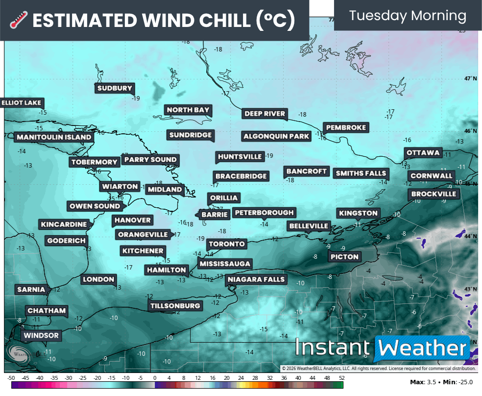
Further north, where the heavy snow is slated to fall, the winds will not be quite as strong, topping out at around 70km/h. This still poses a major issue as it will likely lead to widespread whiteouts, and even crossing the threshold of being a blizzard, across Northern Saskatchewan and Manitoba. These will be treacherous conditions to attempt to travel in this region, so it will be best to postpone any unnecessary travel until the storm is over.
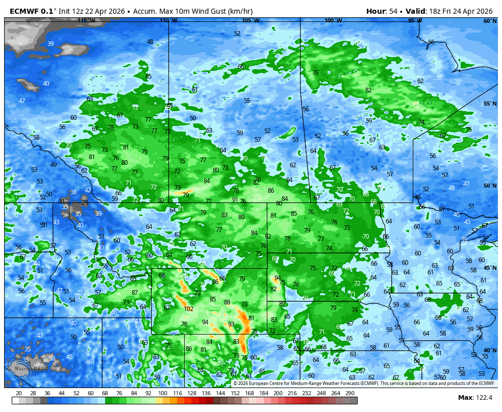
The ECMWF model showing Maximum Wind gust by 12pm CST/1PM CT Friday, courtesy of WeatherBell.