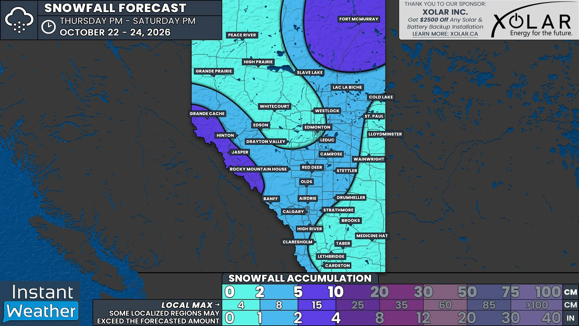
Edmonton Area in the Crosshairs for Strong Severe Thunderstorms Tuesday with Threat of Very Large Hail and Possible Tornadoes

NOTE: YOU CAN CLICK ON THE MAP TO OPEN A ZOOMABLE IMAGE

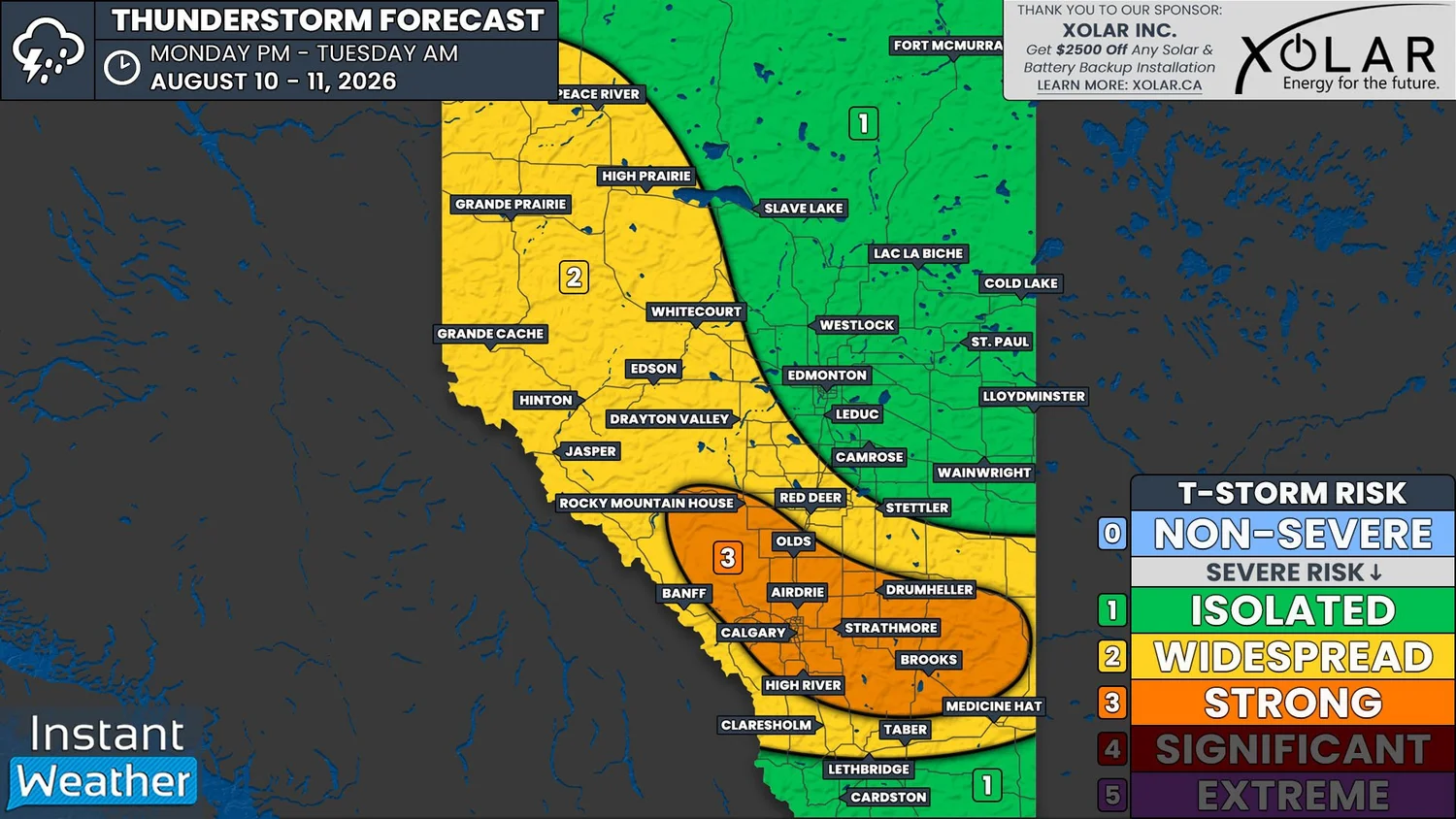
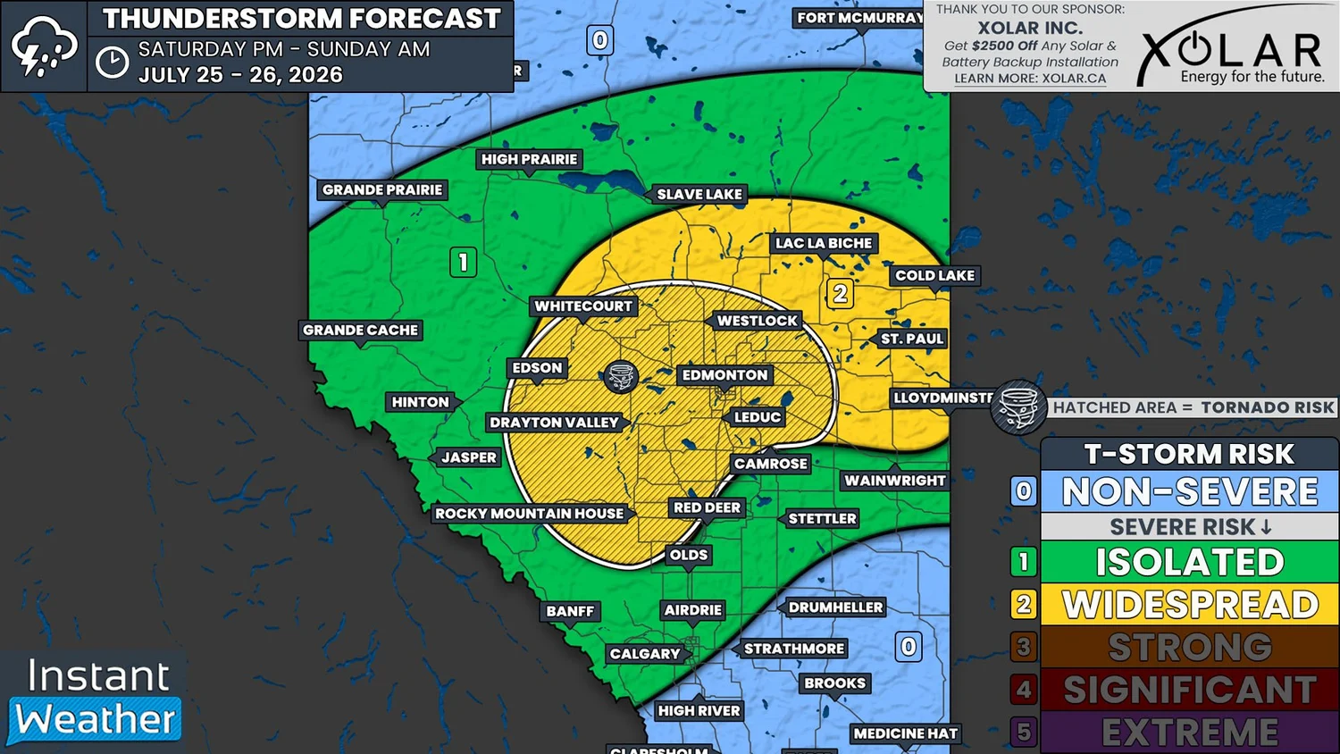
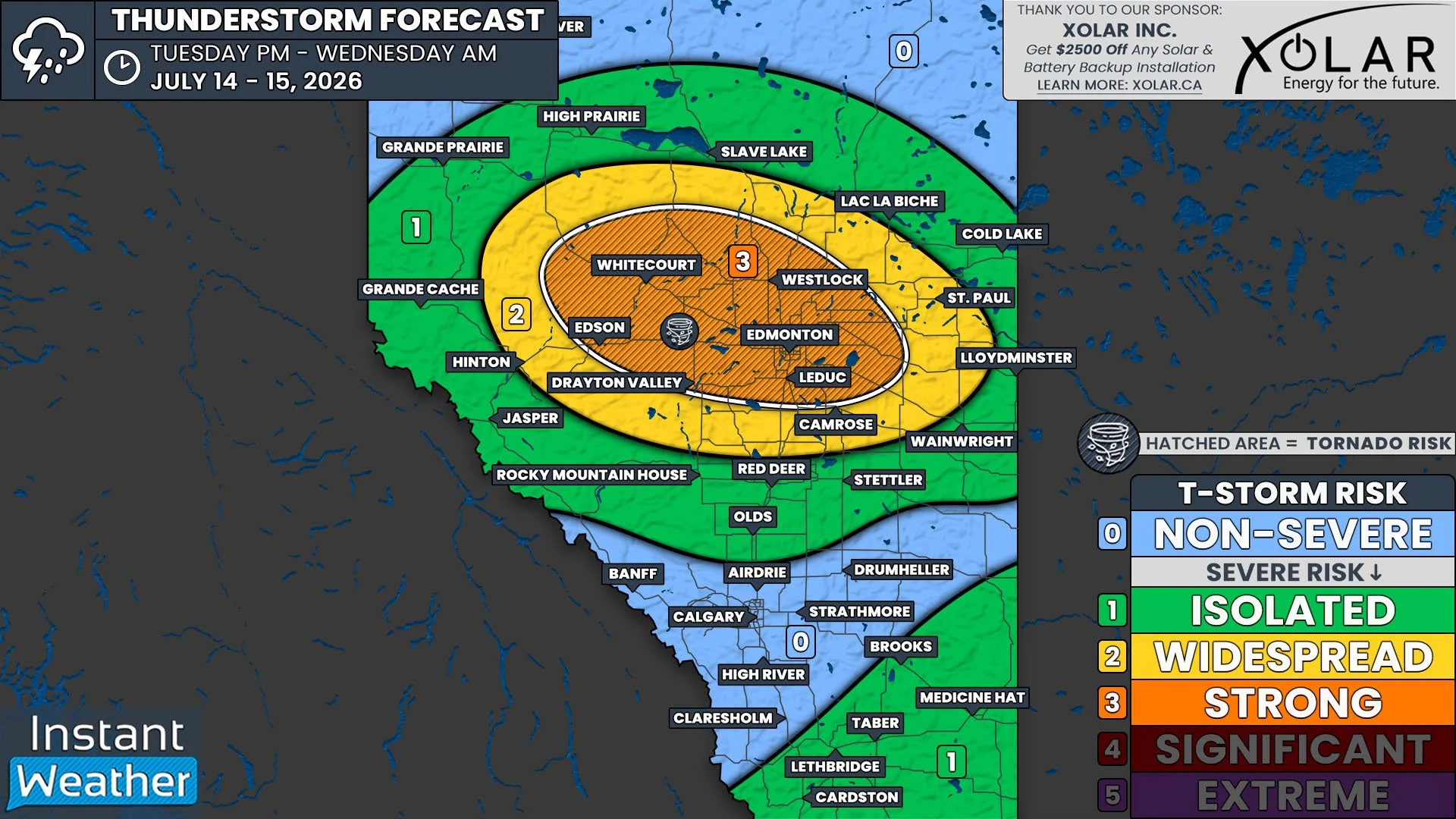
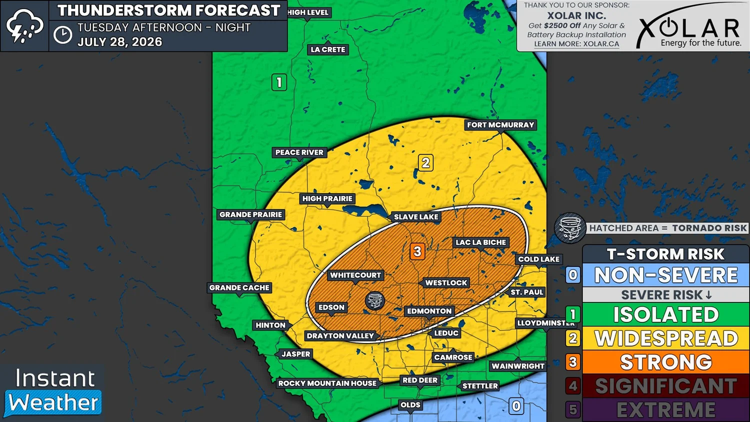
It’ll be yet another day with the threat of strong severe thunderstorms for parts of Alberta. Today’s risk will be along the Highway 43 corridor between Whitecourt and Edmonton, and throughout the surrounding area, including Edson, Drayton Valley, and Westlock.

There will be plenty of instability in the atmosphere across Central Alberta and into parts of Northern Alberta today, with upwards of 3000J/kg of CAPE being shown on weather models beginning this afternoon. Additionally, ample moisture and shear throughout the region will lead to all the necessary ingredients being in place for some strong severe thunderstorms to develop.

Today’s thunderstorms could possibly begin in the Foothills in the mid-to-late afternoon, but it’s more likely that storms will fire up in this area during the early evening. Once the isolated storms do start to develop, they are expected to rapidly strengthen into strong supercells, which will track mostly eastward across the province through the remainder of the evening and overnight.

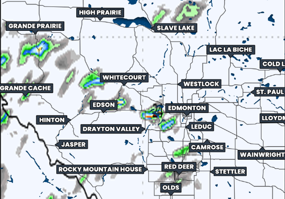
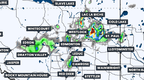
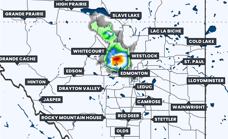
Hourly Precipitation at 1Am MDT, courtesy of weatherbell.

These severe thunderstorms are expected to reach the Edmonton area sometime in the late evening or shortly after midnight, around 11pm-2am. These thunderstorms could very likely maintain their strength up until this point, however there is also the possibility that the storms will weaken to the west, before hitting Edmonton. Regardless, as we progress overnight and into the pre-dawn hours, and the storms continue tracking eastwards, they are expected to weaken considerably and will likely dissipate before reaching the Saskatchewan border.

The greatest threat from the strong supercell thunderstorms today will be very large hail, which could end up being up to tennis ball size. There will also be the risk of damaging wind gusts in excess of 100km/h, intense rainfall, and even the possibility of a tornado or two.

In the meantime, there will be a more isolated severe risk this afternoon and evening in Southeastern Alberta. The storms in this part of the province aren’t expected to be particularly strong, especially when compared to the storms further north, with the main concern being some strong wind gusts, small hail, and pockets of heavy rain.

Given that today’s strong severe thunderstorms will have tornado potential continuing after dark, especially in such a populated area, it’s crucial to ensure that you have all of your devices charged and that you have more than one way to receive critical alerts. We expect to be live-streaming today’s storms once they begin to develop, along with those in Ontario, Quebec, and New Brunswick, so be sure to tune in!


Potential Record-Breaking Heat to Fuel Severe Thunderstorm Threat Across Southern Ontario Tuesday

NOTE: YOU CAN CLICK ON THE MAP TO OPEN A ZOOMABLE IMAGE

Dangerously hot temperatures are returning to Southern Ontario, bringing another multi-day heat wave to the region. This heat wave is expected to peak on Tuesday, when temperatures could climb into the mid to upper 30s across many communities.

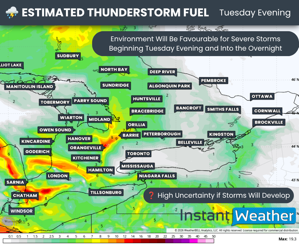
As temperatures rise, so does the instability in the atmosphere, and Tuesday will be no exception. The intense heat will help fuel the potential for strong to severe thunderstorms across parts of Southern Ontario.

The greatest severe weather threat is expected to focus on the Ottawa Valley, where a cold front will move through the hot, humid air during the late afternoon and early evening. As the front arrives, it is expected to spark a line of thunderstorms capable of quickly becoming severe.

The environment appears favourable for some of these storms to develop into supercells capable of producing all severe weather hazards, including destructive wind gusts, golf ball-sized hail and a few tornadoes.

Elsewhere across Southern Ontario, widespread thunderstorm development is not expected as there is no well-defined trigger in place. However, isolated storms could still develop along lake breeze boundaries or from outflow boundaries generated by other storms. With plenty of instability available, any storm that manages to form could become severe. Most communities, however, are expected to remain dry on Tuesday.


Join Us on YouTube for Storm Coverage:

We'll be providing comprehensive live coverage of any storms that develop Tuesday on our YouTube channel. Our team will be tracking storms in real time with live radar analysis, warnings, and storm reports, so if severe weather threatens your area, be sure to join us live to help stay informed.


Another developing story that could have significant implications for Southern Ontario’s weather is the rapid increase in wildfire activity across Northwestern Ontario. A large number of new wildfires ignited over the past day, and the smoke from these fires is expected to begin spreading into Southern Ontario as early as Tuesday. An even more significant plume is expected to arrive on Wednesday.

In addition to air quality concerns, this smoke could also influence thunderstorm development on Tuesday by limiting the amount of sunshine reaching the surface. If enough smoke is present, it could reduce instability and lead to fewer storms than currently expected.

NOTE: YOU CAN CLICK ON THE MAP TO OPEN A ZOOMABLE IMAGE

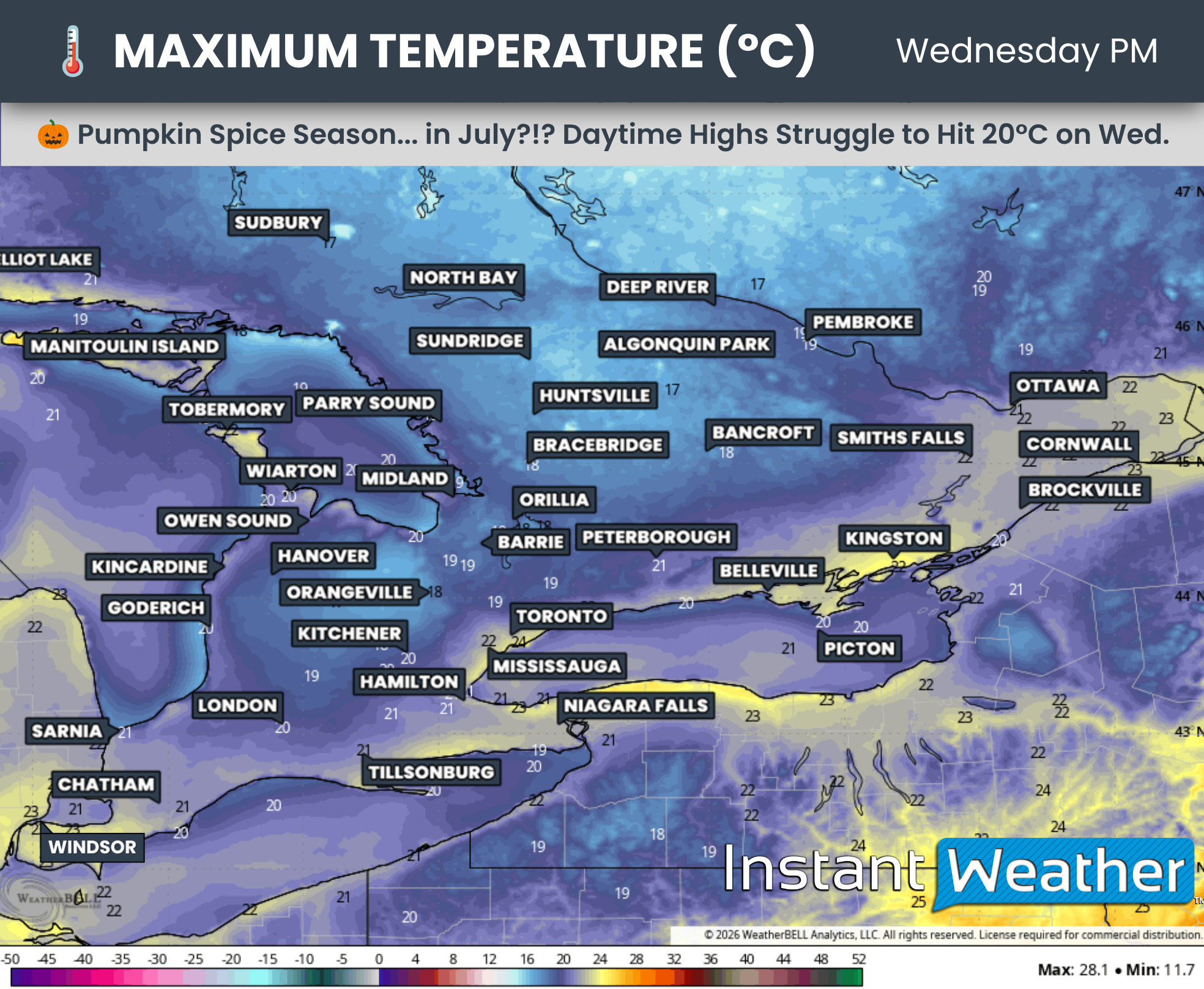
Tuesday is shaping up to be a sweltering day, with temperatures climbing above 35°C across a large portion of Southern Ontario and potentially approaching the 40°C mark in a few locations. That’s before factoring in the humidity, which could make it feel more like the mid to upper 40s.

The hottest conditions are expected in a corridor stretching from Deep Southwestern Ontario through the Golden Horseshoe and into the Ottawa Valley. Afternoon highs here will likely range between 36 and 38°C, with parts of the Greater Toronto Area potentially reaching 39 to 40°C.

One reason the Greater Toronto Area could end up even hotter than surrounding communities is because of the urban heat island effect. Cities are filled with concrete, asphalt and buildings that absorb heat from the sun throughout the day and slowly release it back into the surrounding air. With fewer trees and green spaces to provide cooling, temperatures in urban areas can end up several degrees warmer than nearby rural locations, especially during prolonged heat waves.

The remainder of Southern Ontario can expect highs ranging from 30 to 36°C. Communities located directly along the northeastern shores of Lake Erie and Lake Ontario, as well as the eastern shores of Lake Huron and Georgian Bay, could be 5 to 10°C cooler thanks to cooling lake breezes.

Humidity is not expected to be quite as intense as it was during the late June heat wave, when humidex values approached 50°C in some areas. Even so, it will still make conditions feel like the low to mid 40s, with a few locations around the Golden Horseshoe potentially approaching the upper 40s.

These temperatures can become dangerous very quickly, especially for older adults, young children, people with chronic health conditions and anyone spending extended periods outdoors. Stay well hydrated, avoid strenuous outdoor activities during the hottest part of the day, wear lightweight clothing and seek air-conditioned spaces whenever possible.

Never leave children or pets inside a parked vehicle, even for a few minutes, as temperatures inside can rise to life-threatening levels in a very short amount of time!

DATA FROM WEATHERBELL

The hot, dry weather has also created ideal conditions for wildfire growth across Northwestern Ontario, and we’ve seen exactly that over the past 12 hours.

More than a dozen new wildfires have ignited, with many of them concentrated northwest of Thunder Bay. A southeasterly wind flow is expected to carry smoke from these fires into Southern Ontario over the next several days.

Initially, much of this smoke should remain high in the atmosphere. However, by Wednesday we could be dealing with a significant wildfire smoke event across Southern Ontario as more of the smoke mixes down to the surface, potentially leading to hazardous air quality. More details on that once models start ingesting the data from the new fire.

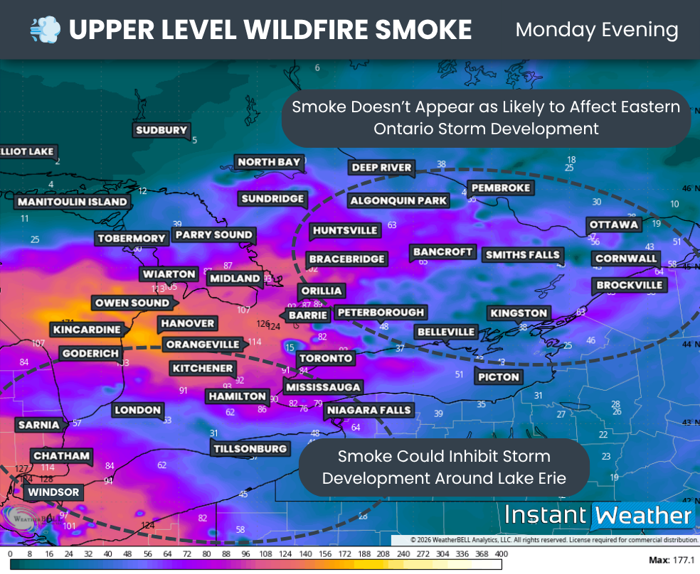
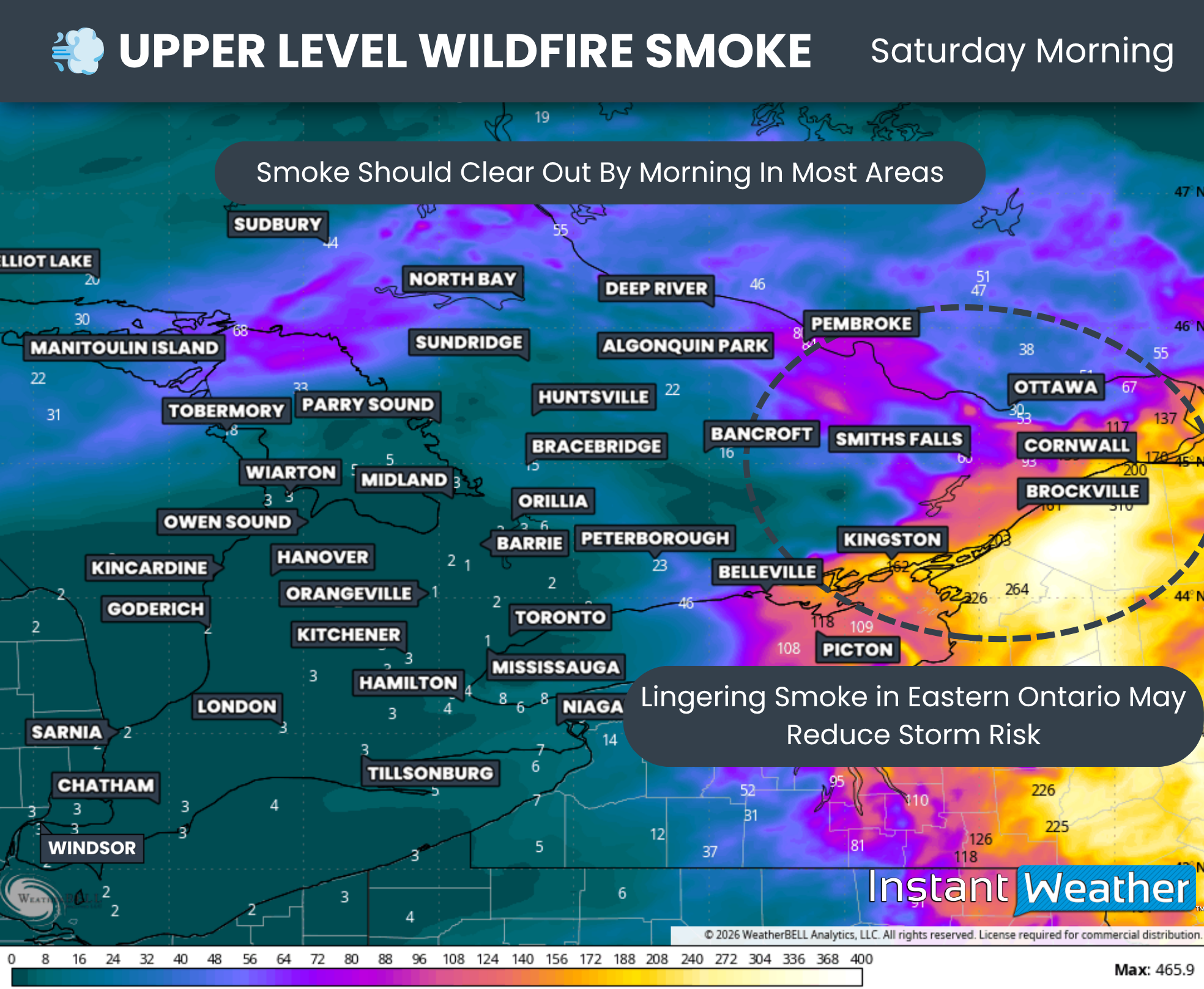
Even Tuesday’s elevated smoke could influence our weather, particularly across Central and Eastern Ontario. We’ve seen in the past that thicker smoke can reduce the amount of sunlight reaching the ground, limiting daytime heating and making it more difficult for thunderstorms to develop.

As a result, there is a real possibility that Tuesday’s severe weather threat could underperform if the smoke becomes thick enough to suppress storm development.

DATA FROM WEATHERBELL

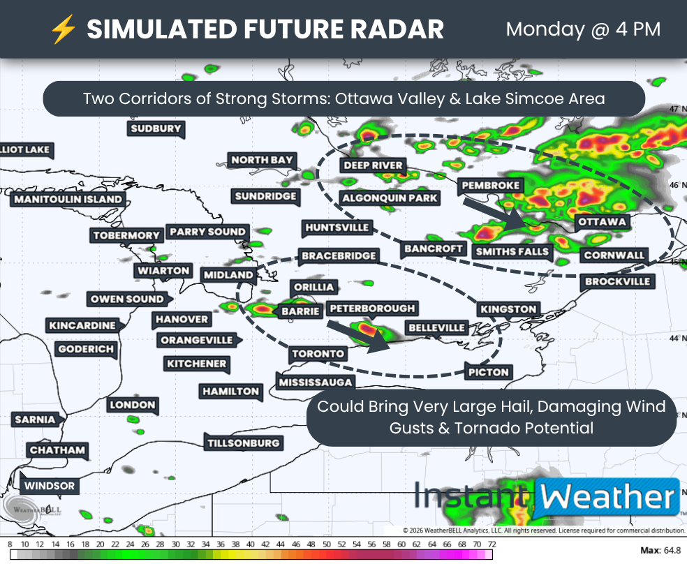
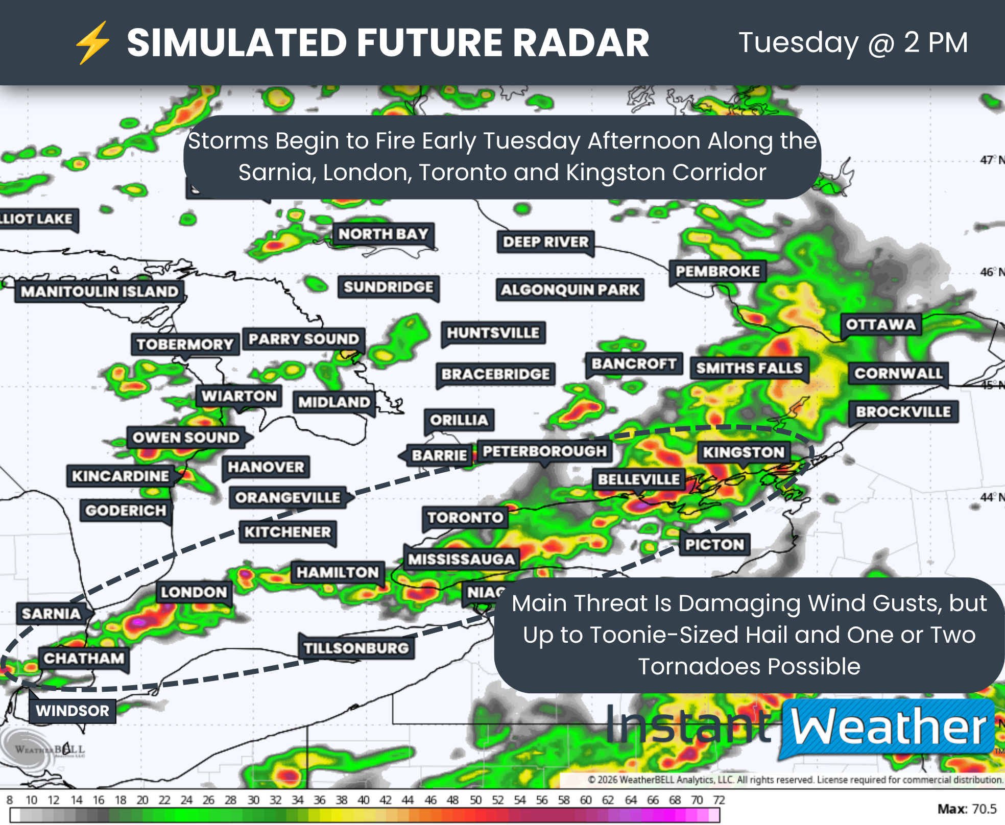
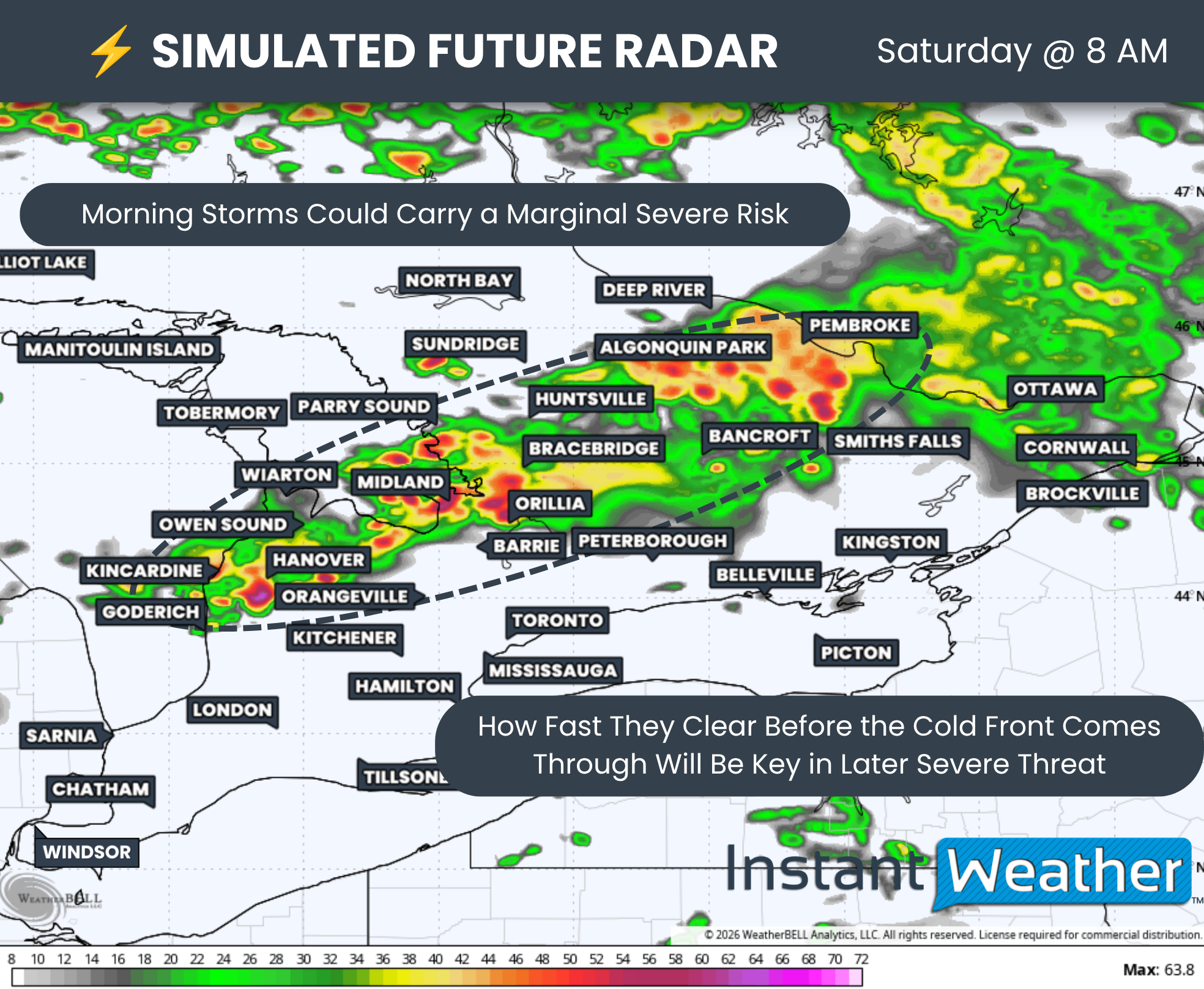
Assuming the smoke does not significantly interfere, the latest model data shows a line of thunderstorms developing around the dinner hour from North Bay to just north of Ottawa.

The exact timing will depend on when the cold front arrives, but the primary threat window currently appears to be between 4 PM and 10 PM.

These storms are then expected to track southeast through the Ottawa Valley, potentially affecting portions of Central Ontario before continuing into southeastern Quebec and eventually crossing into the northeastern United States.

We could also see isolated thunderstorms develop during the afternoon and early evening across other parts of Southern Ontario. These would likely be triggered by lake breeze boundaries or other localized features that weather models often struggle to resolve.

Any storm that is able to develop could quickly become severe, producing damaging wind gusts and large hail. The greatest tornado threat remains focused across Eastern Ontario.

NOTE: YOU CAN CLICK ON THE graphic TO OPEN A ZOOMABLE IMAGE


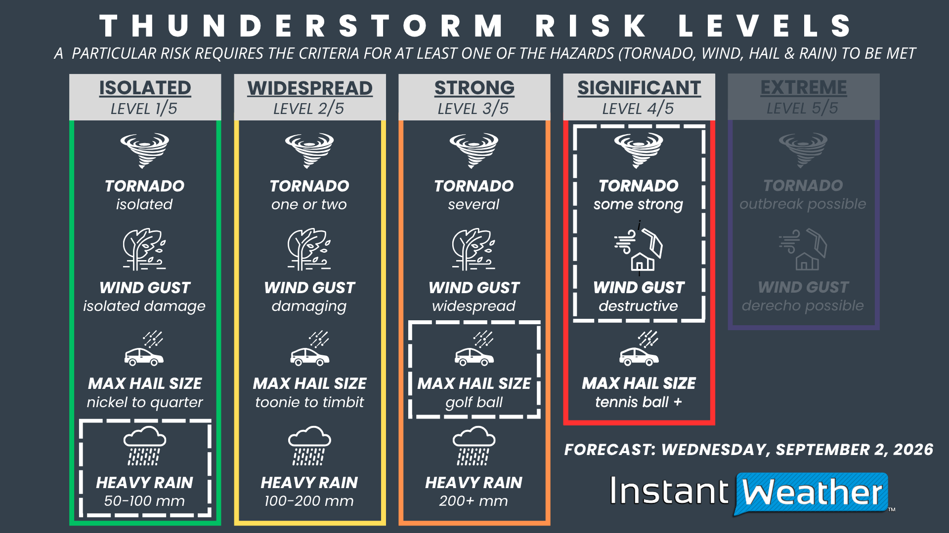
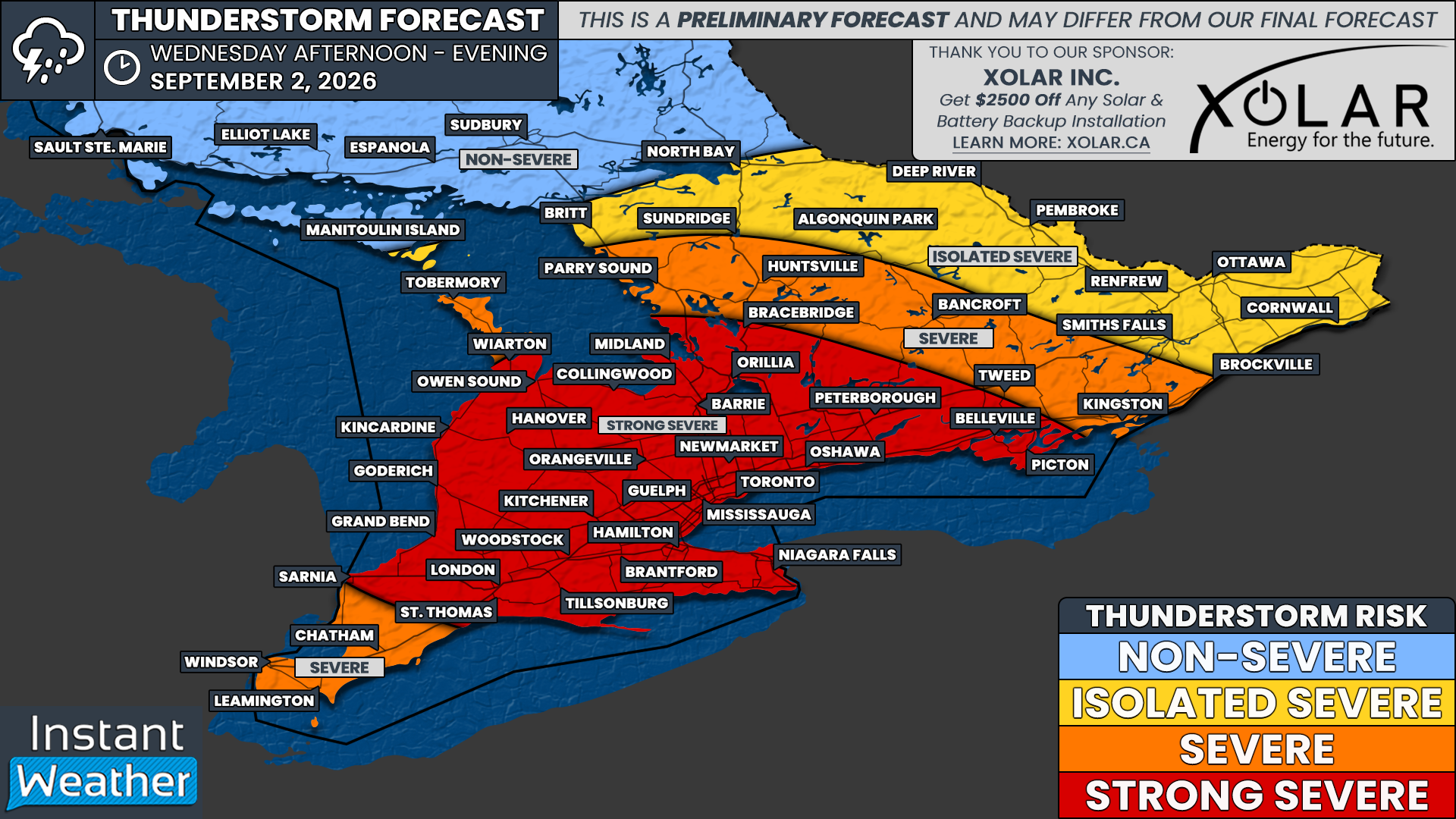
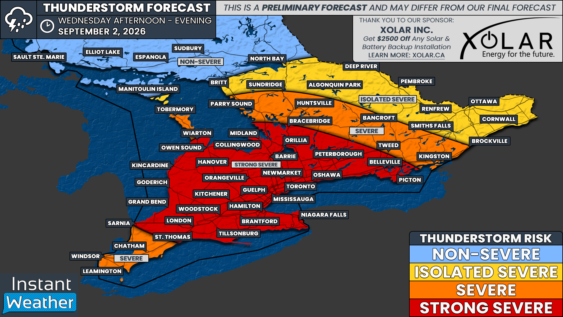
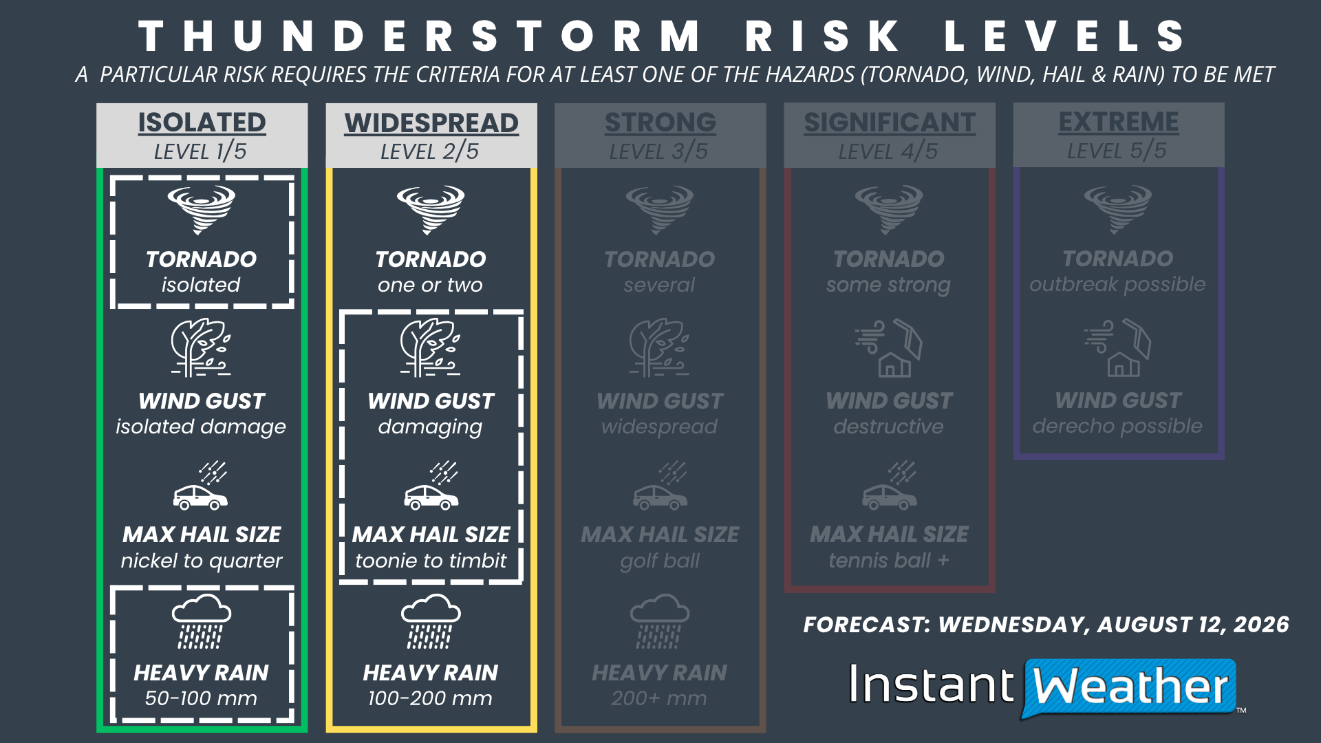
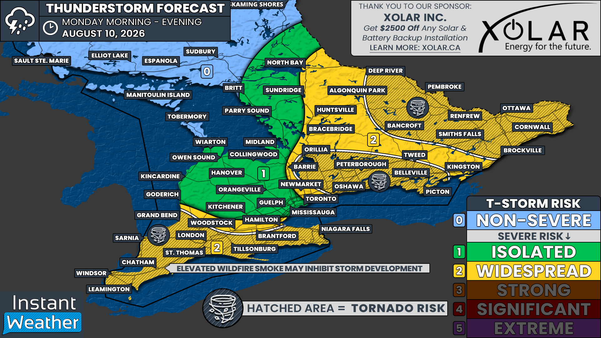
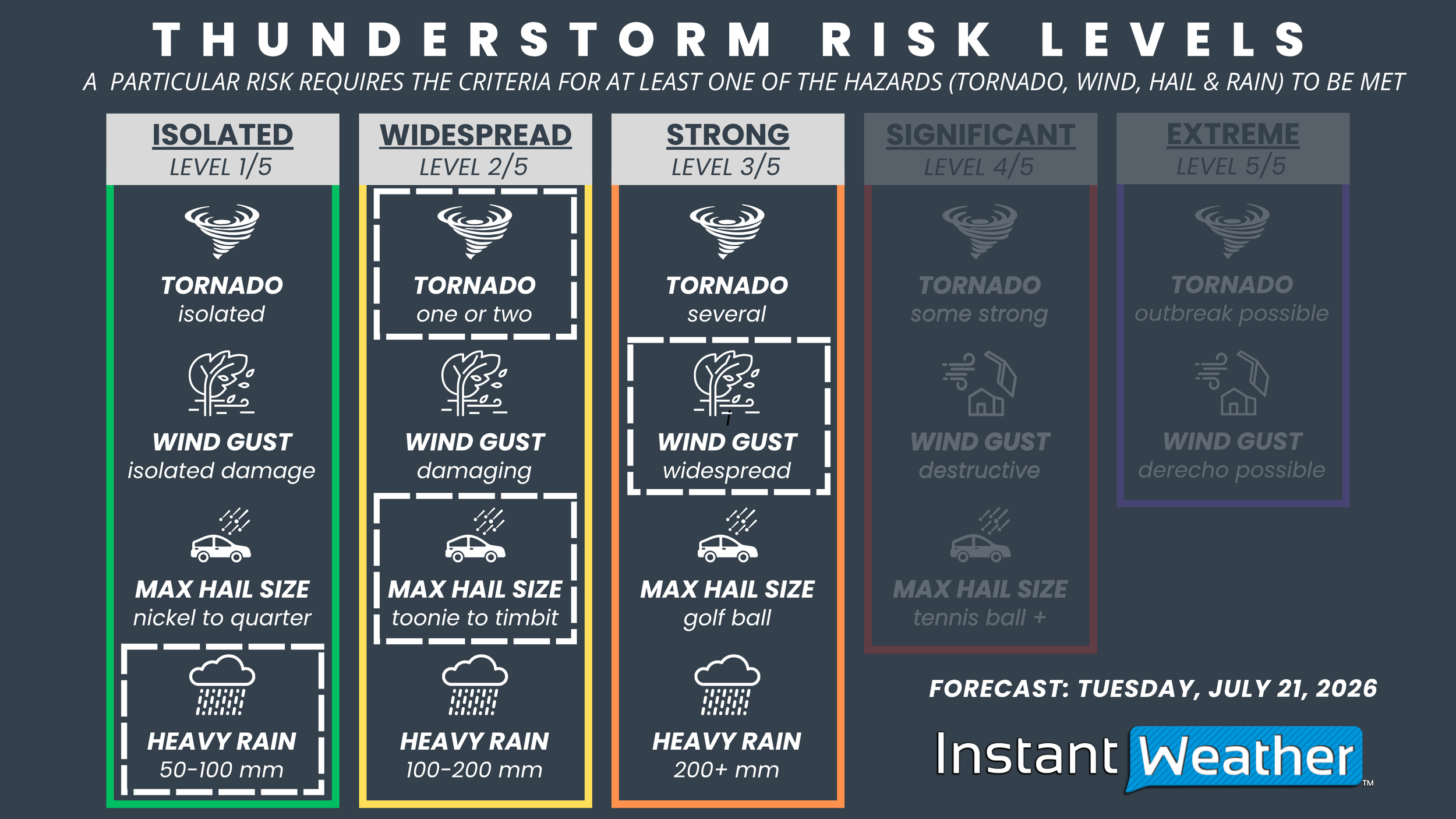
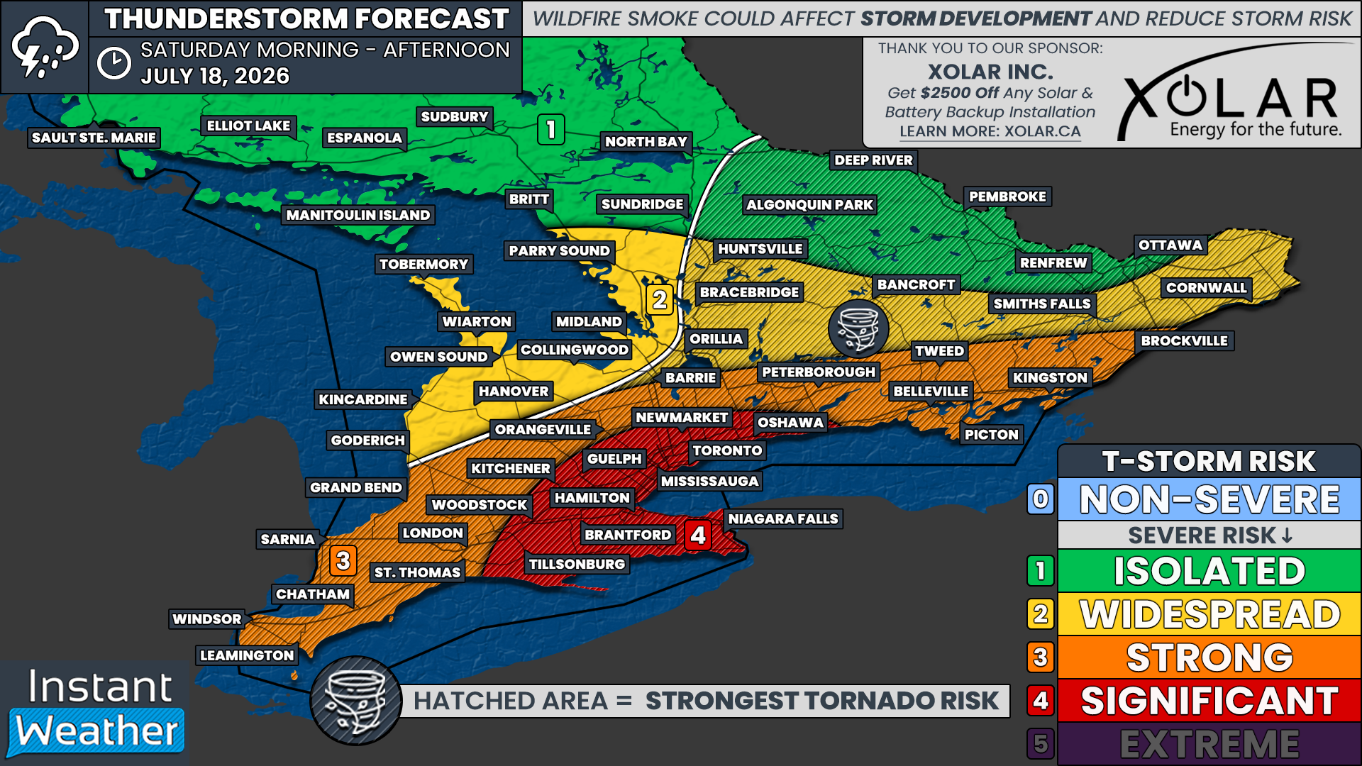
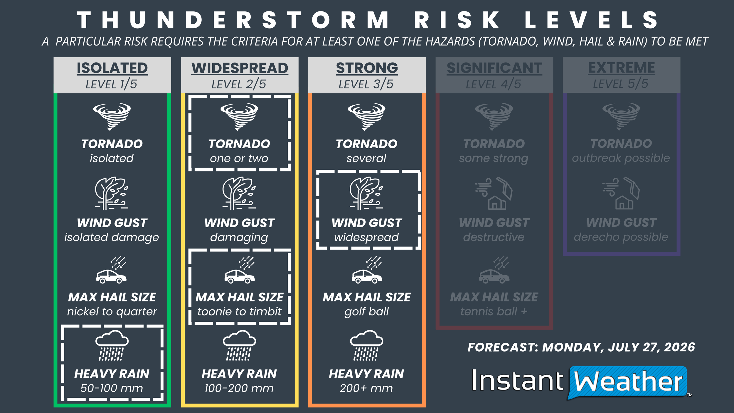
Based on the expected environment, we’re forecasting a “Strong” (Level 3 of 5) severe weather risk for Ottawa, Cornwall, Smiths Falls, Renfrew, Pembroke and Deep River. This reflects the potential for widespread damaging wind gusts, golf ball-sized hail, one or two tornadoes and localized flash flooding.

A “Widespread” (Level 2 of 5) severe weather risk extends across the rest of Eastern and portions of Central Ontario, including Brockville, Bancroft, Huntsville, Algonquin Park, Sundridge and North Bay. Confidence is a bit lower than across the Ottawa Valley, but several severe storms remain possible with damaging wind gusts, Timbit-sized hail and an isolated tornado.

The remainder of Southern Ontario is under an “Isolated” (Level 1 of 5) severe weather risk. Most communities in this area will likely remain storm-free. However, if a thunderstorm is able to develop along a lake breeze or another localized boundary, it could produce isolated damaging wind gusts and up to quarter-sized hail.

Widespread Tornado and Large Hail Threat with Another Risk of Severe Thunderstorms in Alberta & Saskatchewan Saturday

NOTE: YOU CAN CLICK ON THE MAP TO OPEN A ZOOMABLE IMAGE

Following yesterday's widespread severe weather, in which multiple tornadoes were reported to have touched down in Central Saskatchewan, as well as one possibly touching down to the west of Edmonton, we're in for yet another day with the risk for strong severe thunderstorms.

For several days, weather models have been showing that the environment could be extremely unstable today, especially across much of Saskatchewan, which could result in a fairly significant severe weather outbreak. Working against this, however, is the likelihood that there could actually be too heat higher up in the atmosphere, which could create a strong capping inversion that would hinder thunderstorm development. This is expected to be the case for much of Southern Saskatchewan today, where there will be a more isolated severe risk. It's important to note that any storms that are able to develop in this region will probably be quite strong.

Shifting northward, the capping should be less of an issue in Central and Northern parts of Alberta and Saskatchewan. Across this large swath of the Prairies, severe thunderstorms are expected to develop much more readily in a favourable environment.

Although there are already some thunderstorms this morning in Central and Northern Alberta, the storms that we are most concerned about are expected to beginning developing early this afternoon in Western Alberta, which will track mostly eastward through the afternoon.

As these storms cross into Saskatchewan early this evening, they could strengthen considerably as they move through the most ideal environment. These thunderstorms are expected to maintain their strength as they cross Saskatchewan during the evening and into the overnight hours. As they approach the provincial border and cross into Western Manitoba, the storms are expected to weaken and then dissipate in the early morning hours.

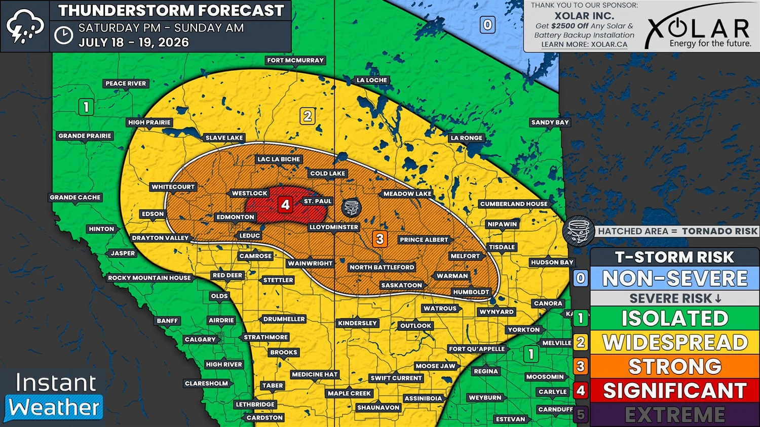
At their strongest, the severe thunderstorms today could easily produce large golf ball to tennis ball size hail, damaging wind gusts up to and possibly exceeding 100km/h, and heavy rain. There will be a widespread risk of tornadoes today in the area outlined in yellow and even in Southern Saskatchewan if storms are able to form there, but the most significant risk will be in the orange region. An area of particular concern today will be around North Battleford, Saskatoon, and Prince Alberta.

This is looking like it could be another long day with a heightened severe weather threat across the Prairies. Given today’s widespread tornado risk, please ensure that you have all of your devices charged and that you have more than one way to receive critical alerts. We expect to be livestreaming today’s storms so be sure to tune in!


Massive Tennis Ball Hail and Tornado Threat from Strong Severe Thunderstorms Across All Three Prairie Provinces Thursday

NOTE: YOU CAN CLICK ON THE MAP TO OPEN A ZOOMABLE IMAGE

Yesterday, two tornadoes have been confirmed to have touched near the Alberta-Saskatchewan border, south of Lloydminster. So far, no damage has been reported from the first tornado that began southwest of Paradise Valley, Alberta. The same can not be said for the second tornado, which tracked through Dillberry Lake Provincial Park, where it damaged trees, flipped a trailer, and caused minor injuries.

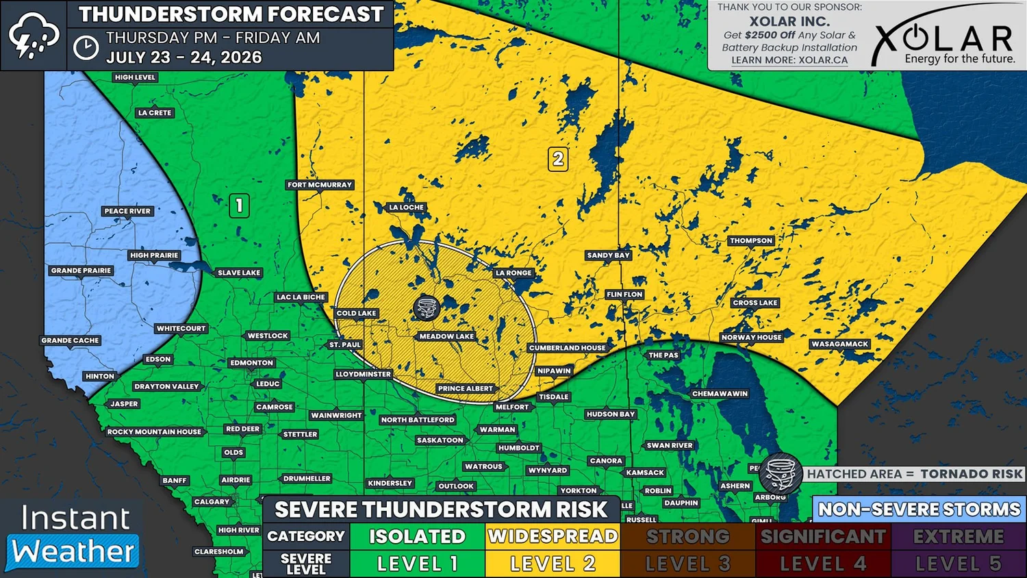
Unfortunately, this area will once again be at risk for tornadoes today, as we are looking at two particular regions in the Prairies where there could be strong severe thunderstorms capable of producing very large hail and tornadoes. The first area of concern will be in Southwestern Manitoba and extending northward into the Parkland and Interlake Regions. The second area is further west, extending southeastward from Wainwright, through Kindersley, to the Moose Jaw and Regina area.

To start things off, we’ll take a look at the severe risk in Eastern Saskatchewan and into Manitoba. As discussed in yesterday’s forecast, last night’s storms did manage to track across Saskatchewan overnight and persist through to the daylight hours today. They weakened considerably after crossing the Manitoba border and have gradually dissipated this morning.

Despite the lingering storms, the same low and frontal boundary setup that triggered yesterday’s tornadoes is positioned over Southern Saskatchewan and it will continue tracking eastward today.

Future Surface weather map with the positions of highs, lows, and fronts displayed for 12pm cst/1pm CDT on Thursday, courtesy of the national weather service.

Temperatures will climb into the mid-to-upper 20s and dewpoints into the low 20s across much of Southeastern Saskatchewan and Southern Manitoba today, meaning there will be plenty of moisture. The environment will also be quite unstable, with CAPE values possibly as high as 3000J/kg. Along with a decent amount of shear, all of the ingredients will be in place for strong severe thunderstorms to develop this afternoon as the low tracks through the region.

Thunderstorms could start to develop in the early afternoon in Southeastern Saskatchewan, along the warm and occluded fronts. However it’s looking more likely that storm initiation will occur on the other side of the Saskatchewan-Manitoba border in the mid-afternoon.

Simulated reflectivity at 3pm CdT, courtesy of weatherbell.

Given the extensive north-south orientation of the warm and occluded fronts, it’s possible that there could be widespread severe thunderstorm development that extends northwards from the international border to north of Flin Flon. While there is this large severe risk, the strongest severe thunderstorms are expected to remain further south.

The storms in Southern Manitoba are expected to strengthen quickly once they develop, especially if they interact with any lingering outflow boundaries from this mornings thunderstorms. If this were to happen, we could see some fairly explosive development in the region. There could be a few supercell storms, but it’s mostly looking like the storms will be multicellular in nature.

As the front slowly continues to track eastward and crosses Manitoba through the afternoon and evening, so too will the storms. In fact, these slow moving, moisture-laden storms could dump a lot of rain over an area that has already been dealing with major flooding issues, so be prepared.

Other than exacerbating the flooding concerns, if things really ramp up this afternoon and evening, the strong severe thunderstorms could potentially produce some massive hail today, with estimates of hail as large as tennis balls being possible. Damaging wind gusts up to 120km/h are also likely with these strong storms, and there will also be a threat of tornadoes if we end up seeing some of that explosive development.

The severe weather threat could possibly move into Winnipeg and the Red River Valley in the evening, but most models are showing the storms tracking southeastward into the States. The possibility of storms in this region is still a bit questionable, so we’re forecasting a widespread risk to the east of the area of strongest storms.

Simulated reflectivity, with added storm motion, at 7pm CdT, courtesy of weatherbell.

While storms are impacting Southern Manitoba, there will also be the risk of some severe thunderstorms further west.

A new low has been forming over Southern Alberta and it could trigger thunderstorms to develop this afternoon, but it’s looking like a boom or bust situation in this region. There will be plenty of moisture and a decent amount of instability, but there could actually be too much shear for thunderstorms to survive.

If storms are able to develop today and they aren’t over-sheared, they will likely be supercells that could start up in Central Alberta and track southeastward across West Central and Southwestern Saskatchewan. Models that are showing thunderstorm development are suggesting that these could end up being long-lived storms again, which could continue into the overnight and early morning hours as they approach the Montana border.

total Precipitation as of 3pm MDT/CST shows possible tracks of long-lived thunderstorms, courtesy of weatherbell.

The greatest risk of strong severe thunderstorms in Alberta and Western Saskatchewan today will exist from Wainwright to Moose Jaw and if these strong storms do develop, it could be a similar situation as yesterday. Very large hail, that could be tennis ball size or larger, would once again be the main severe threat. Damaging wind gusts well in excess of 100km/h will also be possible and there will be the threat of tornadoes, too.

Beyond the two areas we’ve highlighted as having the strongest severe thunderstorms today, there will also be a widespread severe risk across much of the Southern Prairies as a result of a favourable environmental conditions.

Shortly after 10:30am local time, Environment Canada has issued a Yellow Severe Thunderstorm Watch for parts of Central and Southern Alberta. Similar Watches will likely be issued in Saskatchewan and Manitoba in the coming hours.

As always, we will be monitoring today’s thunderstorm development very closely. We intend on live streaming today’s storms, as well as the risk in Southern Ontario, so please be sure to tune in and stay safe!

Severe Storm Risk Targets GTA and Southern Ontario Thursday With Damaging Winds Possible

NOTE: YOU CAN CLICK ON THE MAP TO OPEN A ZOOMABLE IMAGE

With the return of more seasonal temperatures across Southern Ontario, the past week has been fairly quiet on the storm front. That has certainly been a noticeable change compared to the nearly daily severe weather risks we were dealing with during the prolonged heat event that kicked off the month.

However, that quieter pattern is expected to come to an end on Thursday as a cold front sweeps across Southern Ontario during the afternoon, bringing back the threat for severe thunderstorms in some areas.

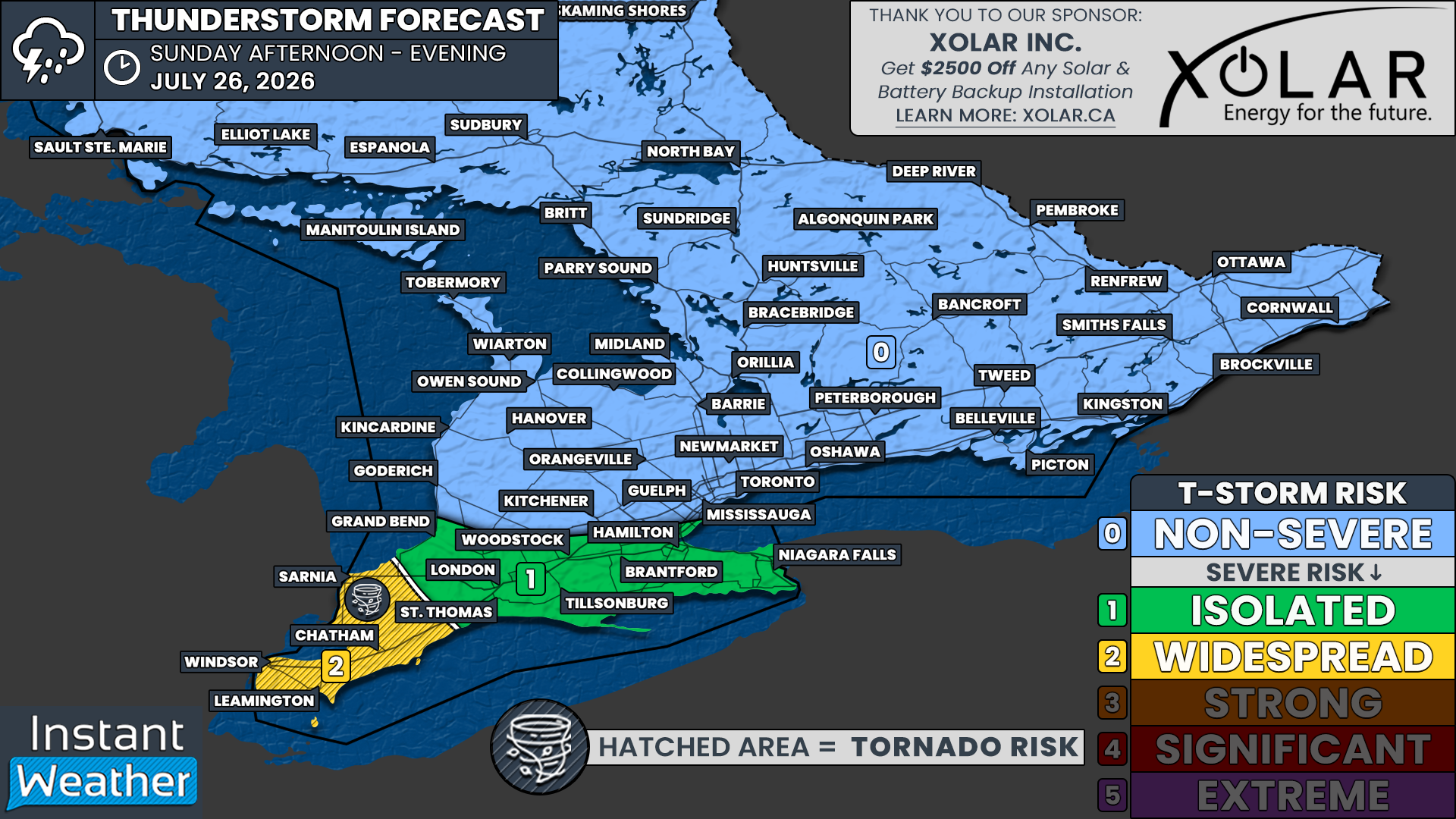
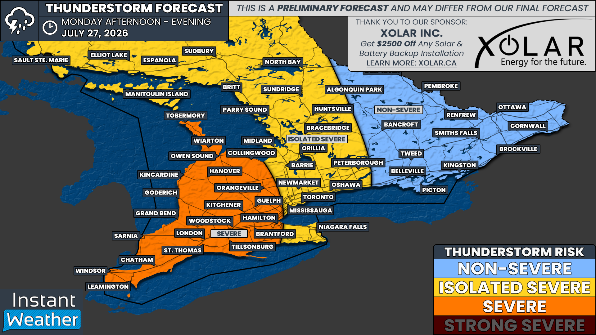
The highest risk for severe weather appears to be focused on Deep Southwestern Ontario, extending along the Lake Erie shoreline, through the Greater Toronto Area and along the Hwy 401 corridor into Kingston. This is where we have a widespread severe weather risk, with multiple severe storms possible through the afternoon.

Based on the latest data, a line of storms is likely to develop along the approaching cold front and move into an environment supportive of some of these storms becoming severe. The main threat appears to be damaging wind gusts, but large hail and localized flooding will also be possible with the strongest storms.

As for the tornado risk, it appears to be highest from around Lake Simcoe eastward into the Kingston area. However, this risk is still fairly questionable and will depend on how storms develop and interact with the local environment.


Join Us on YouTube for Storm Coverage:

We'll be providing comprehensive live coverage of any storms that develop Thursday on our YouTube channel. Our team will be tracking storms in real time with live radar analysis, warnings, and storm reports, so if severe weather threatens your area, be sure to join us live to help stay informed.


The main timeframe for storm development appears to begin during the early afternoon, with storms likely stretching from Lake Simcoe through Kitchener, London and into the Sarnia area between 1 and 4 PM.

These storms are expected to slowly track south and east through the afternoon, potentially moving into the Golden Horseshoe, Peterborough and Kingston area by the mid to late afternoon.

Keep in mind, not everyone will see severe storms. This is not expected to be a solid wall of storms affecting every community. Instead, storms will likely be somewhat isolated to scattered, but the environment in place means that any storm that does develop could become severe.

The storm risk should quickly diminish after the dinner hour as daytime heating fades and the front moves through. However, this will depend on the exact timing of the front. If it arrives a little later than expected, the severe risk may continue into the early evening hours for some areas.

NOTE: YOU CAN CLICK ON THE GRAPHIC TO OPEN A ZOOMABLE IMAGE


Based on the environment, we have gone with a ‘widespread’ severe weather risk, mainly driven by the potential for damaging wind gusts. Nickel to quarter-size hail and an isolated tornado are also possible.

This risk zone includes Windsor, Chatham, Sarnia, London, Hamilton, Niagara Falls, Kitchener, Guelph, Toronto, Newmarket, Peterborough, Belleville, Kingston and Brockville.

We also have an isolated severe risk for the rest of Southwestern Ontario, through Central Ontario and into the Ottawa Valley. This includes Ottawa, Cornwall, Renfrew, Bancroft, Muskoka, Orillia, Barrie, Midland, Collingwood, Orangeville, Hanover, Kincardine and Goderich.

Storms in this zone are more likely to remain non-severe, but we can’t rule out one or two isolated severe storms. This is especially true if the front is slower than expected, which could allow stronger storms to develop farther north and west before tracking into the main risk zone.

Threat of Tennis Ball Hail, Damaging Winds, and Tornadoes on Wednesday as Strong Severe Thunderstorms Take Aim at Parts of Alberta & Saskatchewan

NOTE: YOU CAN CLICK ON THE MAP TO OPEN A ZOOMABLE IMAGE

After a bit of a break yesterday, severe weather returns today to parts of Alberta and Saskatchewan. There is a widespread risk of severe thunderstorms across large swaths of both provinces today, however there is a threat of particularly strong severe thunderstorms for parts of Eastern Alberta and Western Saskatchewan.

The environment will be quite unstable throughout the region today, with CAPE values expected to climb as high as 2500J/kg. Combined with plenty of moisture and a considerable amount of shear, conditions will be favourable for thunderstorm development.

Some storms have already begun this morning to the northwest of Lac la Biche, and the bulk of today’s storms are expected to initiate in the Alberta Foothills later this morning and into the early afternoon. The storms will develop along a warm front that’s associated with a low which will move into Northern Alberta from British Columbia. It’s expected that today’s thunderstorms will start off as small individual storms, but they should quickly grow and strengthen as the track eastward across Alberta and reach the Saskatchewan border by the late afternoon.

Hourly Precipitation at 6pm MDT, courtesy of weatherbell.

The strongest storms of the day are expected to occur during the late afternoon and into the evening, impacting parts of Eastern Alberta approaching the Saskatchewan border and extending eastward as far as Saskatoon. The main risks from these storms will be up to tennis ball sized hail and very damaging wind gusts that could be upwards of 120km/h, however, this area will also have the threat of tornadoes.

As we progress later into the evening and overnight, the storms will continue to track east across Saskatchewan, but they are expected to have weakened slightly. The thunderstorms could end up persisting straight through the night and approach the Manitoba border around sunrise tomorrow.
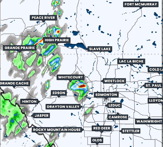
Simulated reflectivity at 6Am CST, courtesy of weatherbell.

There is a bit of uncertainty associated with today’s thunderstorm risk for Southern Alberta. A few weather models are showing little to no thunderstorm activity in this area and this potential lack of development could be due to the presence of smoke from wildfires in British Columbia. Regardless, the environment in this region will still be primed for thunderstorm development, which is why we have opted to forecast a widespread risk for this region.

Environment Canada has already issued Yellow and Orange level Severe Thunderstorm Watches for much of Central and Southern Alberta and these will likely be extended into Saskatchewan in the coming hours. We will be monitoring today’s thunderstorm development very closely and we will possibly go live later on so be sure to stay tuned!


Widespread Strong Severe Thunderstorm Risk Across the Prairies Sunday with Tornado Threat in Southwestern Manitoba

NOTE: YOU CAN CLICK ON THE MAP TO OPEN A ZOOMABLE IMAGE

It’s another day with the possibility of severe weather across the Prairies. Today’s risk extends eastward from Southern Alberta through Central Saskatchewan and throughout most of Central and Southern Manitoba.

There are going to be two areas where we will be watching for thunderstorm development later today. The first being in Southern Alberta and the second in Southeastern Saskatchewan and Southwestern Manitoba.
Starting in Alberta, the combination of heat and moisture from the south, along with considerable instability, will create the ideal environment for severe thunderstorms to develop this afternoon. The storms are expected to be supercells or multicellular that would develop in the Southern Foothills.

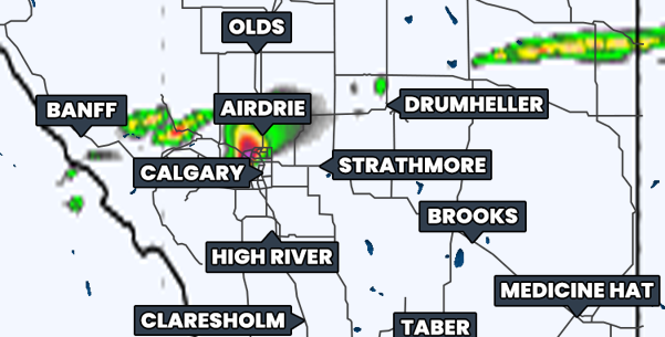
As the storms track eastward beyond the Foothills, they should become severe and possibly long-tracked thunderstorms. Looking at weather models, it appears as though things will strengthen to the east of Calgary, but there will still be an isolated severe risk for the City and the crowds at the Stampede.

Simulated reflectivity at 6pm MDT, courtesy of weatherbell.

The thunderstorms that develop in Southern Alberta this afternoon could very well maintain their strength and continue tracking eastward straight across Central Saskatchewan through the late evening and into the overnight hours. There is a bit of a question mark with this, with some models showing this possibility while others show nothing impacting Saskatchewan.

Regardless, the thunderstorms that do end up developing in this region could be quite strong and have the potential to create very large hail that could possibly be as big as tennis balls, as well as damaging wind gusts in excess of 100km/h.


The secondary area of severe threat for today will exist in Southeastern Saskatchewan and across much of Southern and Central Manitoba.

The development of storms in this region will be courtesy of a cold front from a low pressure system that will move into the region this afternoon. The environment in this area will already be primed with substantial instability (CAPE values upwards of 3000J/kg) and a significant amount of vertical shear so thunderstorms will likely be quite strong, especially in Southwestern Manitoba.

Thunderstorm development in this part of the Prairies could kick off later this afternoon/early evening in deep Southeastern Saskatchewan and Southwestern Manitoba. These storms could then intensify quickly as they track east-northeastward across Southern Manitoba throughout the evening and overnight.

Simulated reflectivity at 9pm CDT, courtesy of weatherbell.

As with to the west, the severe thunderstorms that impact Southeastern Saskatchewan and Manitoba could also be quite strong. The entire region could experience large hail and damaging wind gusts, but in Southwestern Manitoba, where the strongest storms will likely hit, there could be hail as large as tennis balls. There is also the risk of tornado development throughout the evening that extends from Southeastern Saskatchewan to east of Winnipeg and northward into the Parkland and Interlake Regions.

We will be monitoring today’s thunderstorm development very closely and be sure to tune in later when we go live!


Another Round of Damaging Storms Could Hit Southern Ontario Thursday With Tornado Risk Increasing

THIS FORECAST IS SPONSORED BY:

NOTE: YOU CAN CLICK ON THE MAP TO OPEN A ZOOMABLE IMAGE

After an active Canada Day that saw storms sweep through Southern Ontario, causing damage and power outages from widespread damaging wind gusts, Thursday may feel like déjà vu for some areas. For parts of the province, this could be the third severe weather risk of the week.

Fueling all of this active weather is the ongoing heat event, which has led to temperatures soaring into the mid to upper 30s across many locations. Thursday is expected to be similarly hot, creating more than enough instability for another round of severe weather.

While Wednesday’s risk was mainly focused on damaging wind gusts, Thursday could feature a more defined tornado risk, with one or two tornadoes possible. The focus of this tornado risk appears to be in Southwestern Ontario near the Lake Huron shoreline, along with parts of Eastern Ontario, including the Ottawa Valley.

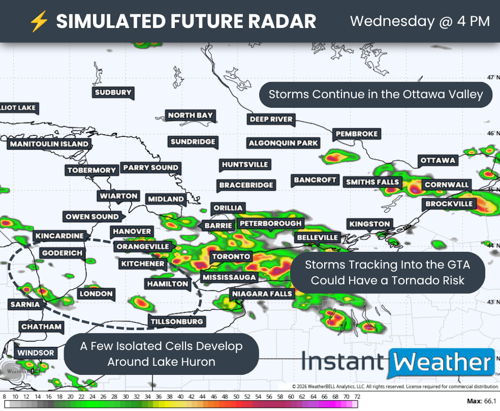
The damaging wind gust threat also remains very present. Similar linear-like storms could sweep through a corridor from Lake Huron into the GTA, and then toward the Lake Simcoe, Peterborough and Kingston areas.

Up to Timbit-sized hail is also possible, especially across Eastern Ontario, along the Lake Huron shoreline and around the London area. In these regions, a more isolated storm mode could support a few supercell thunderstorms.

Once again, models are struggling to pinpoint exactly when and where storm development will happen. They tend to perform poorly in these types of dynamic setups, especially when storms are triggered by smaller-scale features such as lake breezes and outflow boundaries from other storms.

What we do know is where the strongest environment is located, along with a rough idea of where models are most likely to develop storms.

That begins during the afternoon, when we could see isolated cells develop from the Lake Simcoe area down toward Kingston. These storms could support a tornado risk, which is why this corridor is also highlighted on our map for tornado potential.

However, confidence is lower in this area. Not every model shows storm development, so this part of the forecast will depend heavily on whether the right triggers are in place.

Another zone of possible storm development can be found across the Ottawa Valley and Eastern Ontario during the evening. A strong shear environment could support rotation if storms are able to develop.

Similar to the afternoon Lake Simcoe risk, confidence is lower here because not all models show storm development. The threat will depend on whether storms can actually form and take advantage of the environment.

The Lake Huron storms may eventually merge into a larger complex and bring a potential late-night damaging wind gust risk through the GTA and Niagara region.

There is still some question about how long this complex would be able to maintain its strength, especially once we lose daytime heating. However, if it holds together, damaging wind gusts could once again become a concern.

NOTE: YOU CAN CLICK ON THE GRAPHIC TO OPEN A ZOOMABLE IMAGE

THIS FORECAST IS SPONSORED BY:


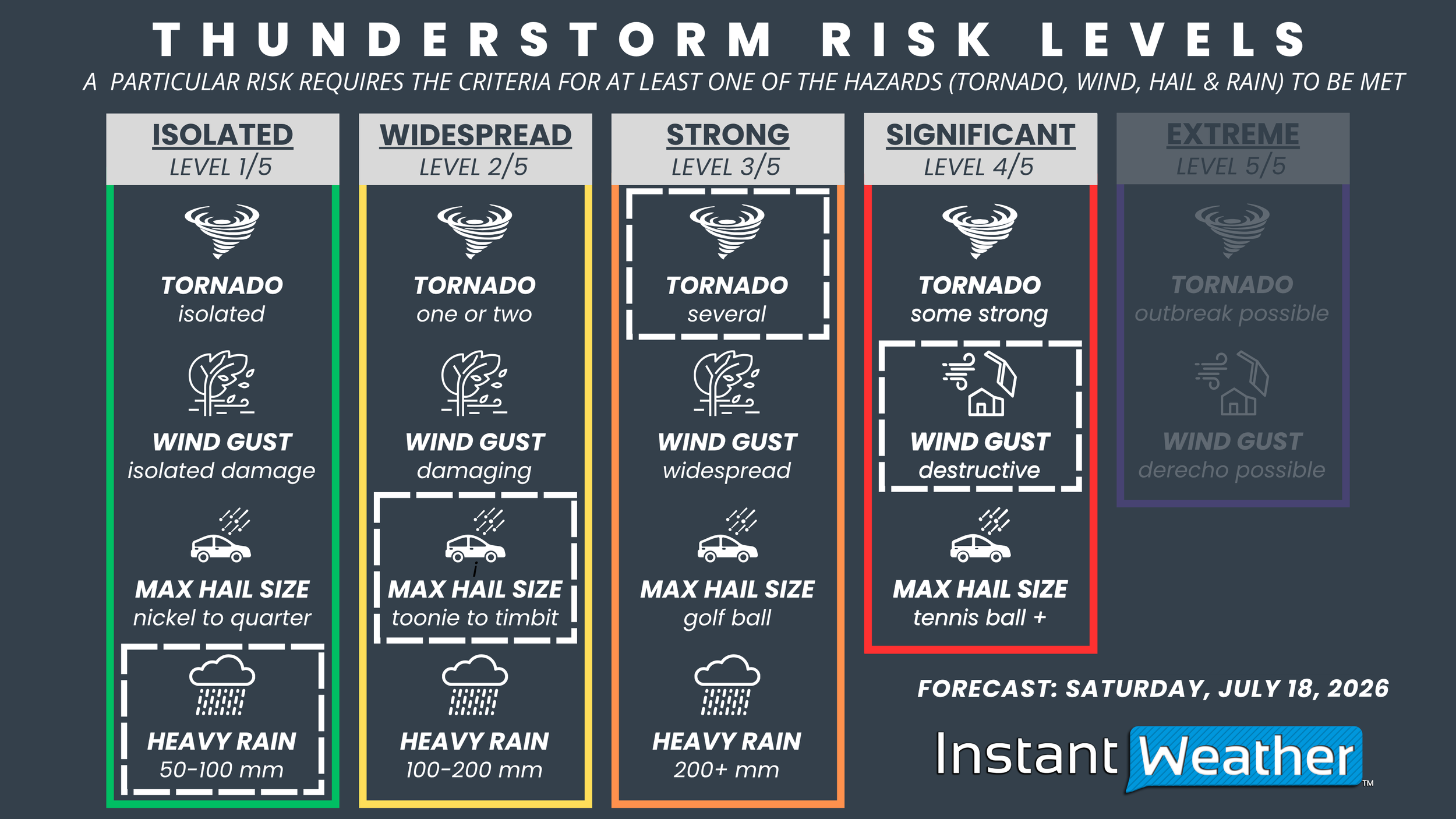
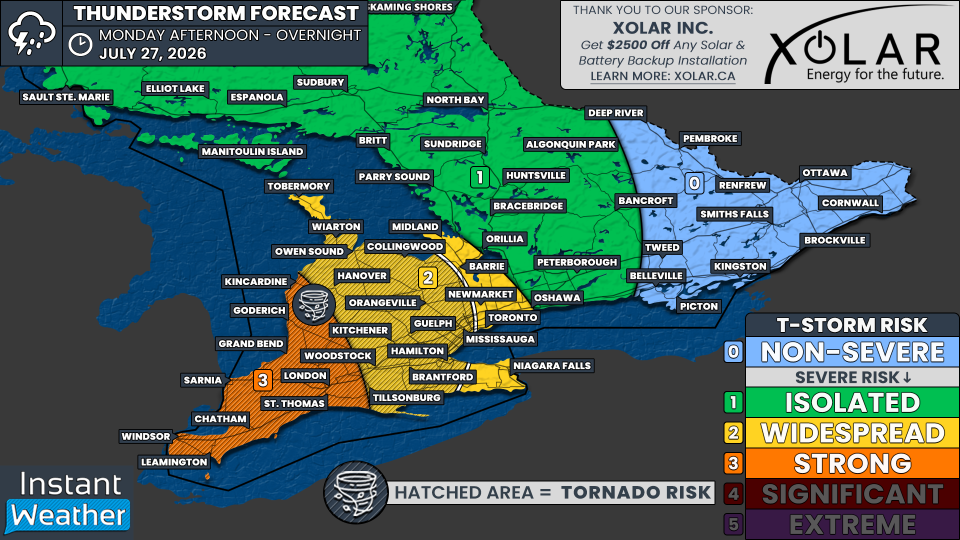
Overall, the forecast for Thursday looks quite similar to Wednesday. We have a “Strong” (Level 3/5) severe risk across a large area, but this time it also includes portions of Deep Southwestern Ontario, including the Sarnia and London areas, along with the Golden Horseshoe.

Other locations included in this risk zone are Goderich, Owen Sound, Kitchener, Hamilton, Guelph, Toronto, Newmarket, Barrie, Orillia, Peterborough, Belleville and Kingston.

This risk is being driven by the potential for strong wind gusts within this corridor, with multiple linear storms possible. If these storms can organize, they could lead to widespread wind damage. There is also the risk for up to Timbit-sized hail and one or two tornadoes.

We have a “Widespread” (Level 2/5) severe risk for Windsor, Chatham and the Lake Erie shoreline, extending into the Niagara region. There is also another “Widespread “ risk zone through Muskoka, Algonquin Park, Bancroft and the Ottawa Valley.

These areas are outside the zone most likely to see the most widespread damaging wind gusts, so the primary threat here will be driven by up to Timbit-sized hail and the risk for one or two tornadoes.

Another major concern is flooding, especially in the Ottawa Valley. This region saw significant flooding on Wednesday after more than 100 mm of rain fell in some areas. Flooding could once again become a serious issue if storms linger over the same communities or repeatedly track over the Ottawa area.

For northern sections of Central Ontario into Northeastern Ontario, including North Bay, Sudbury and Elliot Lake, we have an “Isolated” (Level 1/5) severe risk. We are not expecting widespread severe weather in this area, but with so much energy in the atmosphere, we cannot rule out an isolated pop-up storm capable of becoming severe.

Strong Severe Storm Risk Threatens Canada Day Across Southern Ontario, Damaging Winds and Isolated Tornadoes Possible

NOTE: YOU CAN CLICK ON THE MAP TO OPEN A ZOOMABLE IMAGE

Hot and humid weather has arrived across Southern Ontario just in time for Canada Day, with temperatures soaring into the mid-to-upper 30s, with the humidex making it feel into the 40s. While many will be heading outside to celebrate, this intense heat is also creating an atmosphere that is primed for severe thunderstorms later today.

Unfortunately, this stormy weather could put a damper on Canada Day celebrations, particularly across portions of Southwestern, Central and Eastern Ontario.

We are tracking a conditional severe weather threat for Wednesday afternoon and evening, with the risk potentially continuing into the overnight hours. The hot, humid air will provide plenty of fuel for thunderstorm development. Wherever storms are able to form, they could rapidly become severe thanks to the extremely unstable atmosphere.

In addition to isolated storm development, there is also the potential for one or more organized linear complexes of thunderstorms to move through Southern Ontario. If these systems develop and hold together, they could produce widespread damaging wind gusts across a large portion of the province.

We continue to describe today's threat as conditional because forecast models are doing a poor job of determining exactly where storms will develop. We know the environment is more than capable of supporting severe thunderstorms, but storms first need to form in order to take advantage of the available instability.

Development may be triggered by lake breeze boundaries, leftover outflow boundaries from earlier storms, or other small-scale features that are notoriously difficult to predict ahead of time. As a result, not everyone will see a thunderstorm today, but those that do could experience very intense conditions.


Join Us on YouTube for Storm Coverage:

We'll be providing comprehensive live coverage of any storms that develop today on our YouTube channel. Our team will be tracking storms in real time with live radar analysis, warnings, storm reports and chaser coverage, so if severe weather threatens your area, be sure to join us live to help stay informed.


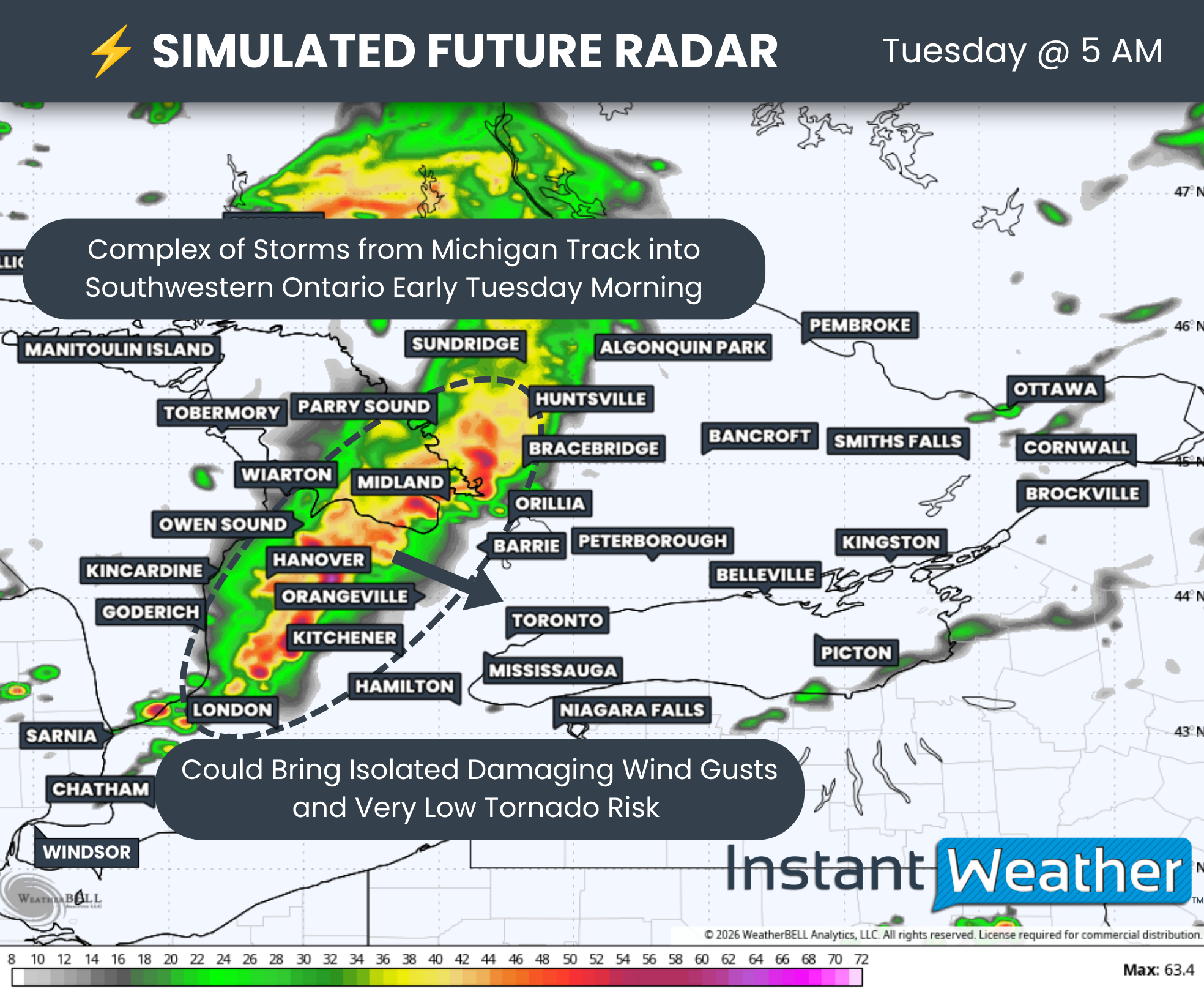
As of 1 PM, we're already watching a strong complex of thunderstorms developing over Northern Michigan that is tracking toward Lake Huron and eventually Southwestern Ontario by the mid to late afternoon. If this complex is able to maintain its strength as it crosses into Ontario, it could produce widespread damaging wind gusts from areas east of Lake Huron through the Lake Simcoe region and eventually into Eastern Ontario.

Additional thunderstorms may also develop later today across Quebec before sweeping into portions of Eastern Ontario and the Ottawa Valley during the evening and early overnight hours.

Outside of these organized storm complexes, isolated thunderstorms may develop almost anywhere across Southern Ontario this afternoon and evening. If they are able to establish themselves before merging into larger clusters, a few discrete supercells could develop.

These storms would be capable of producing damaging wind gusts, hail up to the size of Timbits and an isolated tornado. While the tornado threat appears highest across Eastern Ontario, an isolated tornado cannot be ruled out anywhere in Southern Ontario today.

NOTE: YOU CAN CLICK ON THE GRAPHIC TO OPEN A ZOOMABLE IMAGE

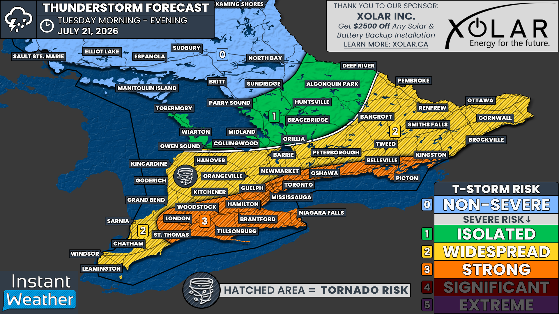
We have a 'Strong' (Level 3/5) severe weather risk for locations including Goderich, Kincardine, Owen Sound, Hanover, Collingwood, Midland, Barrie, Orillia, Bracebridge, Peterborough, Tweed, Bancroft, Smiths Falls, Renfrew, Ottawa, Brockville and Cornwall. This higher risk is primarily driven by the potential for widespread damaging wind gusts this afternoon and evening, although large hail and an isolated tornado are also possible.

Surrounding areas, including Grand Bend, Woodstock, Kitchener, Guelph, Hamilton, Toronto, Newmarket, Oshawa and Kingston, are under a 'Widespread' (Level 2/5) severe weather risk. These locations could also experience damaging wind gusts if storm complexes hold together, although the tornado risk is somewhat lower compared to Central and Eastern Ontario.

We also have an 'Isolated' (Level 1/5) severe weather risk across the rest of Deep Southwestern Ontario, along with the Niagara region. While storm coverage is expected to remain limited here, any storm that does develop could quickly become severe given the highly unstable environment.

Farther north, we have gone with an 'Widespread' (Level 2/5) to 'Isolated' (Level 1/5) severe weather risk across northern portions of Central Ontario, including North Bay and Sudbury. Storms that develop in this region could strengthen before tracking south and eastward into Quebec and Eastern Ontario.

The severe weather threat should gradually diminish around midnight. However, thunderstorms may continue overnight as the atmosphere will remain exceptionally unstable despite the loss of daytime heating. If a mature storm complex is able to move through overnight, isolated severe weather will remain possible, with damaging wind gusts posing the primary threat.

Multiple Tornadoes and Tennis Ball Sized Hail Possible Monday Across Manitoba and Northwestern Ontario

NOTE: YOU CAN CLICK ON THE MAP TO OPEN A ZOOMABLE IMAGE

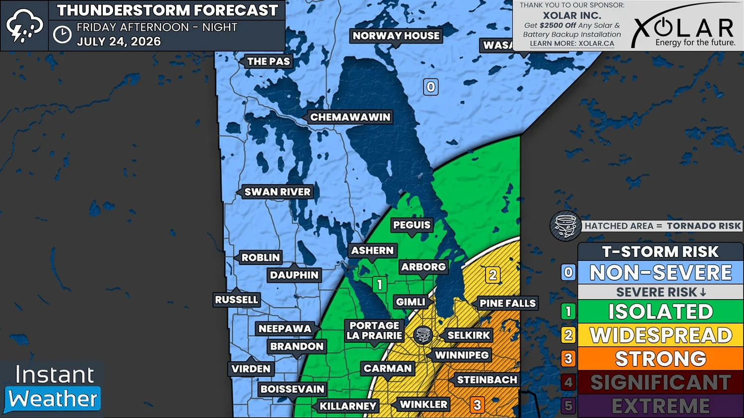
After a destructive severe weather outbreak that brought violent tornadoes to Western Manitoba on Sunday, the risk shifts eastward into Winnipeg, Eastern Manitoba and Northwestern Ontario on Monday.

Based on the latest forecast data, today's storms could bring a similarly dangerous setup with the potential for significant severe weather, including multiple tornadoes, huge hail up to the size of tennis balls, destructive wind gusts in excess of 100 km/h, and areas of flash flooding.

The greatest concern is across areas just southeast of Winnipeg where we have issued a 'significant' severe weather risk. This includes Winkler, Steinbach, Kenora, Dryden, Atikokan and Fort Frances.

Storms that develop in this corridor will have the potential to rapidly become powerful supercells capable of producing all severe weather hazards. The tornado threat is expected to be highest in this zone where atmospheric conditions appear most favourable for rotating thunderstorms.

A 'strong' severe weather risk extends across the rest of South-central and Eastern Manitoba, including Winnipeg, Portage la Prairie, Carman, Killarney, Selkirk, Gimli, Ashern, Arborg, Peguis, Pine Falls, Red Lake, Sioux Lookout and Thunder Bay.

While damaging wind gusts and large hail will likely be the primary hazards across much of this area, an isolated tornado cannot be ruled out, especially across South-central Manitoba and the Interlake region where conditions may still support discrete rotating storms before they begin to organize into larger clusters.

Farther west, there is a widespread to isolated severe weather risk across Western Manitoba, including Brandon, Virden, Dauphin, Roblin and Swan River. Flooding is expected to be the biggest concern in this region as slow-moving thunderstorms could repeatedly track over the same communities.

Rainfall totals could exceed 100 mm in localized areas, leading to flash flooding. An isolated tornado also cannot be ruled out around the Brandon area during the afternoon should any storms remain isolated long enough to become organized.

SIMULATED RADAR - MAP FROM WEATHERBELL

Today's severe weather threat is expected to begin during the afternoon with slow-moving thunderstorms developing across Western Manitoba, particularly near the Brandon area.

These storms will move very little, increasing the risk of training thunderstorms where multiple storms repeatedly pass over the same locations.

This could quickly lead to localized flooding, but these storms may also be capable of producing large hail, damaging wind gusts and even an isolated tornado.

SIMULATED RADAR - MAP FROM WEATHERBELL

The primary severe weather outbreak is expected to unfold later in the afternoon and into the early evening as isolated thunderstorms develop along the international border from Winkler eastward through Southeastern Manitoba and into Fort Frances in Northwestern Ontario.

The atmosphere during this period is expected to be highly supportive of supercell development. Any storm that can remain isolated will have the potential to produce tornadoes, very large hail and destructive wind gusts.

Hail could reach the size of tennis balls in the strongest storms, which would be capable of causing significant damage to vehicles, roofs and crops.

Winnipeg sits near the northwestern edge of the greatest severe weather threat. While current guidance keeps the most dangerous storms just southeast of the city, even a small shift farther west could bring a much higher tornado risk into the Winnipeg area.

SIMULATED RADAR - MAP FROM WEATHERBELL

The tornado threat should gradually decrease after sunset as daytime heating fades and the atmosphere becomes less favourable for discrete supercells. However, that will not mark the end of the severe weather threat.

As the evening progresses, many of the isolated storms are expected to merge into one or more organized lines of thunderstorms. While the tornado risk will lessen, these storm lines could produce widespread destructive wind gusts capable of causing tree damage, power outages and structural damage across parts of Manitoba and Northwestern Ontario.

These storms could reach the Winnipeg and Thunder Bay regions around midnight with another round of severe weather. Although the primary concern overnight will shift toward damaging straight-line winds, an isolated nocturnal tornado cannot be completely ruled out.

The severe weather threat should come to an end across Manitoba after midnight as the storm complex moves eastward. However, portions of Northwestern Ontario may continue to see strong to severe thunderstorms into Tuesday morning before the system gradually weakens and exits the region.


Tornado Risk for Regina Area as Significant Severe Storm Risk Target Saskatchewan & Manitoba Saturday

NOTE: YOU CAN CLICK ON THE MAP TO OPEN A ZOOMABLE IMAGE

After a brief reprieve from active weather across Saskatchewan and Western Manitoba, the threat of severe thunderstorms returns on Saturday. This round of storms could bring a potentially significant severe weather risk to portions of Southeastern Saskatchewan, especially around Weyburn and Estevan.

Isolated thunderstorms are expected to develop near the International Border around the dinner hour. Any storms that form could quickly become supercells capable of producing all severe weather hazards, including tornadoes, golf ball-sized hail and destructive wind gusts up to 120 km/h.

There is also a strong severe weather risk extending northward toward Assiniboia, Moose Jaw and Regina. An isolated tornado cannot be ruled out in these areas as well, although confidence in storm development is lower compared to locations closer to the border.

Further south, additional thunderstorms are expected to develop across Montana and North Dakota. As the evening progresses, these storms are forecast to merge into a large complex that will race northeast toward Saskatchewan and Southwestern Manitoba.

The earlier isolated supercells over Southeastern Saskatchewan are expected to be absorbed into this larger storm complex as it crosses the border. As this happens, the primary threat will shift from large hail and tornadoes to widespread damaging wind gusts as the storms organize into a fast-moving line during the mid and late evening hours.

This line is expected to sweep northeast from Regina toward the Manitoba border. There is still some uncertainty regarding how well it will maintain its strength after sunset, as the loss of daytime heating will reduce available instability. However, we expect at least an isolated to widespread severe weather risk to continue past midnight as the storms approach the Yorkton and Brandon corridor.

SIMULATED RADAR - MAP FROM WEATHERBELL

Based on the latest data, isolated thunderstorms are most likely to develop between 5 and 7 PM CST near the International Border. These storms could impact the Weyburn and Estevan areas as they rapidly intensify into supercells capable of producing large hail, damaging wind gusts and tornadoes.

The environment will be particularly favourable for tornadic development during the first few hours of these storms' lifespan. The greatest tornado risk appears to be closest to the border, although this threat could extend northwest toward Moose Jaw and Regina if storms are able to develop there during the late afternoon and early evening.

SIMULATED RADAR - MAP FROM WEATHERBELL

As the mature line of storms over Montana and North Dakota advances into Saskatchewan, the earlier isolated storms are expected to merge into the line, forming a bowing segment stretching from Regina to the Manitoba border.

Although the tornado threat will decrease once the storms become linear, a brief QLCS spin-up tornado cannot be ruled out, particularly near any bookend vortices that develop within the line. The primary hazard, however, will become widespread damaging wind gusts, with localized gusts over 100 km/h possible. The hail threat will also diminish by this stage, although quarter to toonie-sized hail may still accompany the strongest storms.

The line will continue sweeping across Southeastern Saskatchewan and into Southwestern Manitoba during the overnight hours. While isolated damaging wind gusts will remain possible within the strongest portions of the line, there is still uncertainty regarding how well the storms will maintain their intensity after midnight.


Southern Ontario Faces Severe Storm and Tornado Risk Thursday Ahead of Possible Canada Day Heatwave

THIS FORECAST IS SPONSORED BY:

NOTE: YOU CAN CLICK ON THE MAP TO OPEN A ZOOMABLE IMAGE

While the latter half of June has been relatively quiet across Southern Ontario when it comes to severe weather, thanks to cooler temperatures dominating the region, that pattern is about to change in a big way. As we head into the final days of June, much warmer and increasingly humid air will begin pushing into the province, bringing with it a rapidly increasing risk for thunderstorms.

The first significant opportunity arrives on Thursday, when portions of Southwestern Ontario could see a widespread severe thunderstorm risk. An isolated severe threat may also extend farther east into parts of the Golden Horseshoe and Central Ontario.

If thunderstorms are able to develop during the afternoon and early evening, they will move into a very favourable environment capable of supporting supercell thunderstorms. These storms could produce all modes of severe weather, including toonie-sized hail or larger, damaging wind gusts in excess of 100 km/h, torrential rainfall and even a few isolated tornadoes.

The most favourable environment currently appears to be across areas including Sarnia, Chatham, Grand Bend, Goderich and London. However, isolated thunderstorms could also develop as far north as the Bruce Peninsula, east toward Lake Simcoe, and south into portions of the Greater Toronto Area. While the tornado threat decreases farther away from Lake Huron, it cannot be completely ruled out as far east as Kitchener, Hamilton and portions of the southern Georgian Bay shoreline.


Join Us on YouTube for Storm Coverage:

We'll be providing comprehensive live coverage of any storms that develop on Thursday afternoon on our YouTube channel. Our team will be tracking storms in real time with live radar analysis, warnings, storm reports and chaser coverage, so if severe weather threatens your area, be sure to join us live to help stay informed.


SIMULATED RADAR - MAP FROM WEATHERBELL

Thursday's forecast does come with one important complication. Morning showers and non-severe thunderstorms are expected to move through Southwestern Ontario before spreading into Central and Eastern Ontario during the day.

As we've seen many times before, morning convection can make or break an afternoon severe weather event. If clouds and showers linger too long, they can prevent the atmosphere from recovering enough to support stronger storms later in the day.

On the other hand, if skies clear by around the noon hour, as many of the latest models suggest, there should be several hours available for temperatures and instability to quickly rebound.

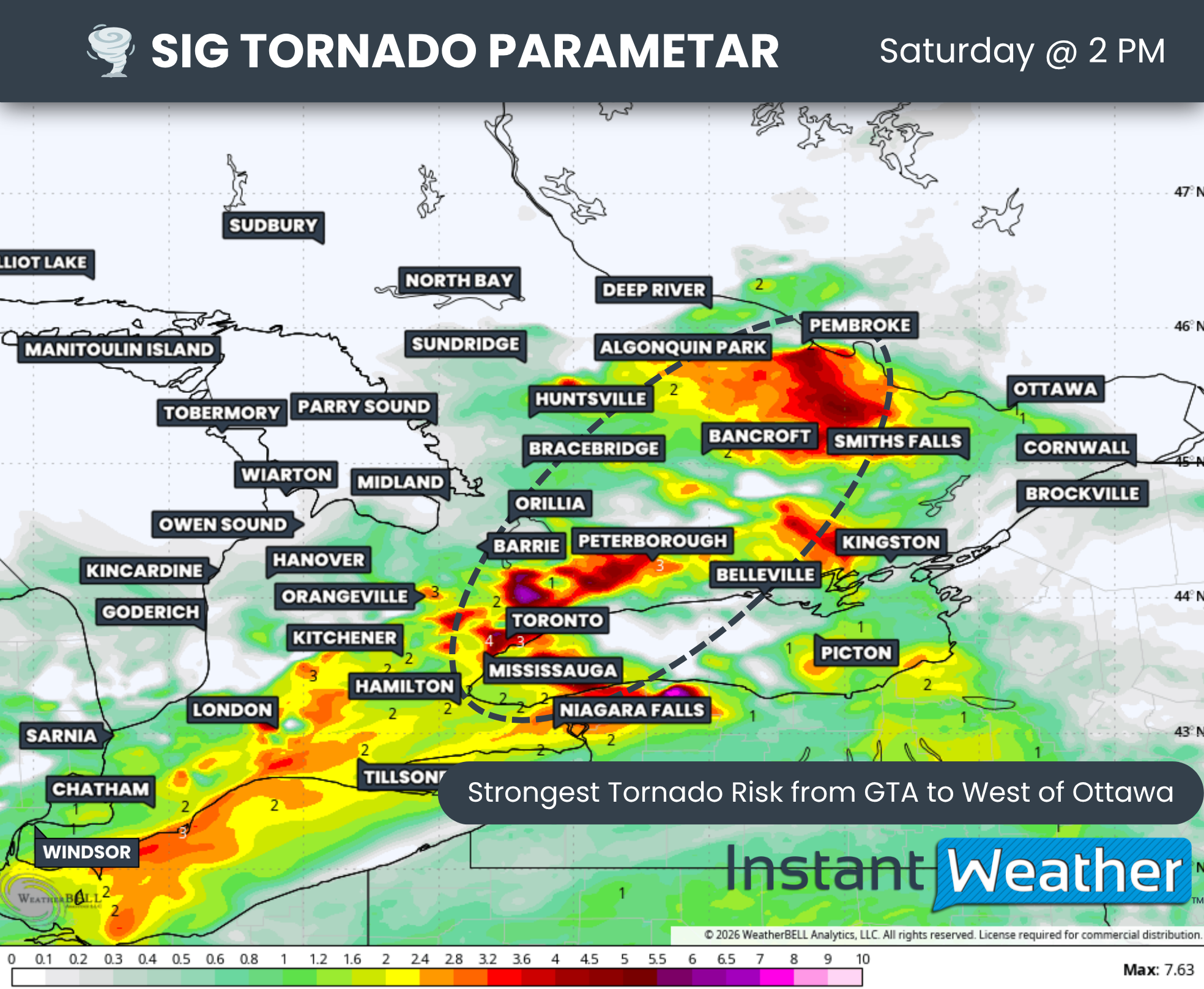
Significant Tornado Parameter - MAP FROM WEATHERBELL

By the mid-afternoon, the atmosphere is expected to become increasingly supportive of severe thunderstorms, with the highest risk developing between roughly 2 PM and 6 PM. The strongest combination of instability and wind shear currently appears to be centred near the Lake Huron shoreline, extending into Sarnia and Chatham.

The latest Significant Tornado Parameter (STP) data also highlights an enhanced corridor stretching from the Michigan border across Lake Huron into Southwestern Ontario. Should storms form within this corridor, they could rapidly intensify into rotating supercells capable of producing very large hail, damaging winds and isolated tornadoes.

SIMULATED RADAR - MAP FROM WEATHERBELL

THIS FORECAST IS SPONSORED BY:

There remains some disagreement among the forecast models regarding exactly where storms will first develop.

Some models initiates storms as early as 3 PM across Michigan before they quickly cross into Deep Southwestern Ontario. This scenario would place communities such as Sarnia, Grand Bend, Goderich and London at the greatest risk.

Other models delay development until later in the afternoon or early evening, with storms forming closer to the Hanover to Grand Bend corridor before tracking southeast toward London, Kitchener and possibly Hamilton. Regardless of which solution verifies, the greatest tornado potential continues to favour areas along and just inland from the southeastern Lake Huron shoreline.

Additional isolated thunderstorms may also develop around Lake Simcoe and into the Greater Toronto Area during the late afternoon and early evening. While the environment in these areas appears less favourable for widespread severe weather, a few stronger storms cannot be ruled out. The primary threats would be hail up to quarter size along with isolated damaging wind gusts.

As the sun sets Thursday evening, the severe weather threat should gradually diminish as daytime heating is lost. However, scattered non-severe showers and thunderstorms may continue well into the overnight hours, particularly across Central and Eastern Ontario.

TEMP ANOMALY - MAP FROM WEATHERBELL

Looking beyond Thursday, the severe weather threat briefly settles down. Friday may bring a very isolated thunderstorm risk across Eastern Ontario, particularly near the Ottawa Valley, while much of the weekend currently appears relatively quiet from a severe weather perspective.

The bigger story heading into next week will likely be the return of significant heat.

Temperatures are expected to steadily climb through the weekend, with many areas approaching or exceeding 30°C by Monday. Current medium-range guidance suggests the heat could continue to intensify into the middle of next week, potentially peaking around Canada Day.

Some forecast models are indicating temperatures running between 5 and 10°C above seasonal averages, with localized anomalies approaching 15°C in parts of Ontario on Canada Day. If those projections verify, daytime highs could reach the low to mid 30s across portions of both Southern and Northern Ontario.

When combined with increasing humidity, it may feel close to 40°C in many communities.

This surge of heat and humidity will also provide plenty of fuel for additional thunderstorm development. While it is still too early to determine exactly which days will carry the greatest severe weather risk, there are increasing signs that we could be entering a much more active pattern over the next one to two weeks. Exactly when storms develop will depend on the arrival of cold fronts and other triggering mechanisms, something that will become much clearer once higher resolution models come into range.

We'll continue monitoring both Thursday's severe weather potential and the possible prolonged heat event expected next week. Stay tuned for forecast updates throughout the coming days as confidence continues to increase.

Widespread Severe Thunderstorms Possible Across Southern Alberta and into Southwestern Saskatchewan Today with Slight Risk of a Tornado

NOTE: YOU CAN CLICK ON THE MAP TO OPEN A ZOOMABLE IMAGE

Severe thunderstorms are going to be likely across Southern Alberta and into parts of Central Alberta and Southwestern Saskatchewan today. A cold front associated with the low pressure system that’s responsible for the heavy rainfall in Central Alberta will be the trigger for thunderstorm development this afternoon and evening.

Temperatures are expected to climb into the low to mid-20s, but dewpoints are expected to be fairly low, barely reaching mid-teens for most of Southern Alberta and Southwestern Saskatchewan. This lack of moisture could hamper thunderstorm development, however some moisture from the north could make its way into the region later today, which would make up for the lower dewpoints.

Simulated reflectivity at 3pm MDT, courtesy of weatherbell.

Thunderstorms are expected to develop early this afternoon in the Foothills as individual cells. These storms will likely be severe for most of the region, but there is a more isolated severe risk closer to the low pressure center, in the Edmonton area and westward.

As the storms progress eastward through the afternoon and evening, they are expected to eventually merge into a line. This transition to a linear storm mode will bring a more widespread severe risk across Southeastern Alberta and eventually into Southwestern Saskatchewan later in the evening (around 8-10pm).

The severe risk does not extend too far eastward into Saskatchewan because the storms will weaken later in the evening. This will lead to a more isolated threat into the Swift Current area by around midnight before it’s expected that the storms become non-severe for the rest of the overnight period.

Simulated reflectivity at 9pm MDT, courtesy of weatherbell.

Across most of Southern Alberta and stretching into parts of Central Alberta, including Red Deer, and Southwestern Saskatchewan is where there is the greatest risk for widespread severe thunderstorms today. In this region, the main severe weather threats will be strong wind gusts above 100km/h and large hail that could be as big as ping pong balls. There is also a small risk of a tornado today, but that will be very conditional on there being enough moisture moving into this area from the north ahead of the thunderstorm development.


Powerful June Storm System Could Bring Damaging Winds and Isolated Tornadoes to Southern Ontario Overnight

NOTE: YOU CAN CLICK ON THE MAP TO OPEN A ZOOMABLE IMAGE

An unusually strong and deepening low pressure system for mid-June is set to track through the Great Lakes region overnight Wednesday and into Thursday. This powerful system will bring the potential for severe weather to a large portion of Southern Ontario, with the greatest threat occurring late tonight and into Thursday morning.

The same system is expected to produce a significant severe weather outbreak across portions of Illinois, Indiana and Michigan this afternoon and evening. In those areas, forecasters are highlighting the risk of violent tornadoes, destructive wind gusts and large hail as a potent combination of instability and wind shear develops ahead of the approaching low pressure system.

As this line of storms pushes eastward into Michigan tonight, it is expected to gradually weaken before reaching Ontario. However, weakening does not necessarily mean the severe threat will disappear.

Even in a decaying state, this line of storms could still bring impactful weather to portions of Southwestern Ontario, especially areas closest to the international border and along the Lake Huron shoreline.

Based on the latest forecast data, the primary threat appears to be damaging wind gusts in excess of 100 km/h. In localized areas, stronger wind gusts could occur if isolated downbursts develop within the line of storms. These stronger pockets of wind have the potential to cause tree damage, power outages and scattered property damage.

While the tornado threat will be considerably lower than what is expected across parts of the United States, it cannot be completely ruled out.

The atmosphere over Deep Southwestern Ontario will remain supportive of some rotation early in the night, particularly while the line of storms is still relatively organized. Any tornado risk would likely be brief and localized in nature, but the strong dynamics associated with this system mean it is something we will be watching closely.

Another factor adding complexity to this forecast is the strength of the low pressure system itself.

In addition to thunderstorm-related winds, very strong winds will be present just above the surface overnight. Normally, a temperature inversion would act as a lid and prevent those stronger winds from mixing down to ground level. Current indications suggest that inversion should remain in place for much of the night.

However, if portions of that stronger wind are able to reach the surface, isolated non-thunderstorm wind gusts in excess of 90 km/h would be possible. This risk appears highest near the shorelines of Lake Huron and Lake Erie where local effects can help enhance wind gusts.


We’ll be closely monitoring this severe weather threat throughout the evening and overnight hours.

If conditions warrant, we’ll be going live on our YouTube channel with real-time storm tracking, radar analysis, warning updates and coverage of any severe weather that develops across Southern Ontario.

Be sure to subscribe to our YouTube channel HERE and turn on notifications so you don’t miss any live coverage. Whether it’s damaging winds, tornado warnings or rapidly changing conditions, we’ll be there to keep you informed every step of the way.


Heavy rainfall will also accompany this system. Many areas will receive beneficial rainfall, but localized torrential downpours could lead to rainfall amounts exceeding 50 mm in a relatively short period of time. If storms repeatedly move over the same area, flash flooding could develop, especially in urban locations and areas with poor drainage.

The highest severe weather risk tonight stretches across Deep Southwestern Ontario and portions of the Lake Huron shoreline. This includes Windsor, Leamington, Chatham, Sarnia, Grand Bend, Goderich and Kincardine.

In these areas, storms could begin arriving as early as 8 to 9 PM and continue through the overnight hours. Damaging wind gusts remain the primary concern, although heavy rain and an isolated tornado cannot be ruled out.

As the line progresses eastward, it is expected to reach the London, Woodstock, Kitchener, Guelph, Orangeville and Hanover areas around or shortly after midnight. There remains some uncertainty regarding exactly how much strength the storms will retain by this point. However, the potential still exists for several pockets of damaging winds to survive farther inland.

The tornado threat should be lower compared to areas farther west, but strong winds and localized flooding will continue to be concerns as the line moves through.

By the time the storms reach Central Ontario and the Golden Horseshoe during the overnight hours, the severe threat should be decreasing further. That said, this remains a powerful weather system and some stronger portions of the line could still produce isolated wind gusts approaching 90 km/h.

As a result, we continue to highlight an isolated severe weather risk for Toronto, Hamilton, Niagara, Newmarket, Barrie, Orillia, Bracebridge, Peterborough and Bancroft.

Attention will then shift to Eastern Ontario during the early morning hours on Thursday. Unlike areas farther west, there are indications that the atmosphere may begin to recover somewhat as the main line approaches. There is also the potential for additional isolated thunderstorms to develop behind or ahead of the main line shortly after sunrise.

This could allow for a secondary severe weather threat across portions of Eastern Ontario, particularly near the international border and into the Ottawa Valley. This broader morning severe weather risk includes Kingston, Brockville, Smiths Falls, Cornwall, Ottawa and Picton.

Should additional storms develop within this environment, all severe weather hazards would be possible including damaging wind gusts, heavy rainfall, hail and even an isolated tornado.

Forecast confidence in the tornado threat remains lower due to the early morning timing and questions surrounding how much instability can develop. However, the environment bears watching closely given the strength of the overall weather system.

The severe weather threat is expected to gradually come to an end from west to east through Thursday morning, with most areas seeing the risk diminish by early afternoon.

Even after thunderstorms exit the region, conditions will remain quite blustery throughout the day. Strong non-thunderstorm wind gusts may continue across much of Southern Ontario as the powerful low pressure system pulls away from the Great Lakes.

Strong Winds and Timbit Sized Hail Possible with Widespread Risk of Severe Thunderstorms in Southern Alberta & Saskatchewan Tuesday

NOTE: YOU CAN CLICK ON THE MAP TO OPEN A ZOOMABLE IMAGE

It’s looking like it’ll be an active day for some parts of Alberta and Saskatchewan today. A low pressure system from Southern British Columbia will track southeastward through Southern Alberta and Saskatchewan today, which will trigger the development of thunderstorms across the region.

Temperatures are expected to climb into the low to mid-20s, with dewpoints possibly into the mid-teens, across Southern Alberta and Saskatchewan, which should help fuel thunderstorm development. There will be a modest amount of CAPE in the region, with weather models showing upwards of 1000J/kg for some areas. While this is not a great deal of instability, the combination of shear and a mechanism for lift will be enough for scattered thunderstorms to develop across the region.

Simulated reflectivity at 2pm, courtesy of weatherbell.

Non-severe thunderstorms have already developed this morning in Central Alberta. As the low continues tracking southeast into Southern Alberta, so too will the thunderstorms and starting in the early afternoon, it’s likely that the storms that develop will become severe.

The bulk of the thunderstorm activity is expected to make its way into Southern Saskatchewan later in the afternoon, around 3-5pm. Behind the initial cluster of storms in this area, additional storms are expected to develop to the west, in Southern Alberta. Most of these storms will likely be severe, but there is a more isolated severe risk that will extend eastward across much of the rest of Southern Saskatchewan.

The thunderstorms will gradually weaken through the evening as they continue tracking into Montana and most of the storms should cross the international border by midnight. However, there is a chance that some storms could linger in Southern Saskatchewan into the early morning hours.

Simulated reflectivity at 6pm, courtesy of weatherbell.

An area that stretches from northwest of Calgary southeastward into Southwestern Saskatchewan, shown in yellow on our forecast map, is where there is the greatest risk for widespread severe thunderstorms today. Across this region, the main threat from thunderstorms today will be strong wind gusts in excess of 100km/h, however there is also the threat that these storms could produce large hail that could be as large as Timbits and maybe even as large as golf balls. Given that at least one tornado is confirmed to have touched down in Northern Alberta from this system last night, the possibility of additional tornadoes today can not be ruled out.


Wickedly Windy Weekend in Store Across Alberta, Widespread Gusts up to 100km/h

NOTE: if you click or tap on this image you can zoom in

It’s going to be a blustery weekend across Alberta, with strong wind gusts in excess of 70km/h expected at some point over the next two days for most of the province. These strong winds will strike in two rounds as two separate systems are slated to track through the Prairies this weekend.

The first system will begin to make its way into Northern Alberta Friday evening. it will bring a mixture of snow, rain, and freezing rain to the region overnight and through Saturday morning.

This system won’t bring too much snow to the area; a maximum of 5-10cm is expected and this will be isolated more to the Northeast. As far as freezing rain is concerned, it will be patchy and occur south of where the snow will fall. Total accretion will be limited to 1-2mm, but this will still be enough for untreated surfaces to become slippery.

The rdps model showing total snowfall as of 2pm mt on Saturday. courtesy of WeatherBell.

To the south of the passage of this system, it’s a completely different story. High temperatures on Saturday are expected to be well above seasonal throughout Central and Southern Alberta, climbing into the double digits and maybe approaching the 20°C mark closer to the US border.

The first round of strong winds will also be found south of the system that will be tracking through Northern Alberta. The winds will start to pick up overnight Friday and peak Saturday morning. Wind gusts of 70-90km/h are expected through the Foothills and stretching across the width of the province to the north of Edmonton. Meanwhile, slightly weaker gusts, in the 50-70km/h range, will impact much of the rest of Central and Southern Alberta.

The rdps model showing showing wind gusts on Saturday at 11am mt. courtesy of WeatherBell.

This first round of strong winds will start to die down in the afternoon and evening for most of the province. However, the gusts will remain strong throughout the Rockies and communities closer to the International border. Beyond these areas, things will become calm for a few hours before the second system begins to make its way into the province later Saturday evening.

This second system is also expected to move through Northern Alberta, but it will track slightly to the south. Once again, snow is expected to fall across a swath of Northern Alberta crosses through the region from Saturday evening to Sunday evening, with models suggesting that up to 20cm could fall.

The winds are expected to be even stronger on Sunday as the cold front associated with the second system pushes southward and also leads to much cooler temperatures across most of the province. The winds will ramp back up Saturday evening and continue into Sunday afternoon before things start to quieten down in the evening. Widespread gusts up to 100km/h are likely during this time and gusts exceeding 100km/h can be also expected in Southwest Alberta.

The rdps model showing 24 hour snowfall amounts as of 9am mt on Monday. courtesy of WeatherBell.

The end of the strong winds won’t be the end of active weather for the weekend. Snow is expected to develop Sunday evening across the Southern Foothills, which will spread eastward into the early morning hours of Monday before dissipating. Around 5-15cm of snow can be expected by lunchtime on Monday from Olds to the Montana border.

Blowing Snow and Near-Blizzard Conditions Could Threaten Friday Evening Commute Across Southern Ontario

NOTE: YOU CAN CLICK ON THE MAP TO OPEN A ZOOMABLE IMAGE

This week has mostly offered a much-needed reprieve from what felt like an endless onslaught of snow that dominated much of January. For many across Southern Ontario, it finally felt like winter eased up a little. Aside from an Alberta Clipper earlier this week, snowfall became lighter and more scattered, and we even managed to climb out of the deep freeze over the past few days, with temperatures returning closer to seasonal norms for early February.

That quieter stretch is now coming to an end as we head into the weekend. A fast-moving but potent weather system is set to cross the region on Friday, bringing a quick blast of heavy snow, strong winds, and sharply falling temperatures. While this will not be a long-duration storm, its timing and intensity could still cause significant disruption.

The main feature to watch will be a cold front sweeping across Ontario on Friday afternoon and evening. Along the leading edge of this front, a frontal squall is expected to develop. This type of setup is known for producing intense snowfall over a very short period of time, often accompanied by rapidly worsening visibility.

As this squall moves through, whiteout conditions are likely to develop with little warning. Snowfall rates could become very heavy for one to two hours in many areas, which is more than enough time for roads to become snow-covered and slippery before plows are able to respond.

Wind will be another major factor with this system. In the wake of the cold front, wind gusts are expected to ramp up quickly. Many areas could see gusts exceeding 70 km/h, with even stronger gusts possible in some locations. This combination of fresh snow and strong winds will lead to widespread blowing snow and significantly reduced visibility.

Unfortunately, the worst of these conditions is expected to line up with the afternoon and early evening commute across much of Southwestern and Central Ontario. Travel conditions could deteriorate rapidly during this window, especially on highways and open rural roads where blowing snow tends to be more severe.

Snowfall totals from this system are not expected to be extreme by winter standards. Most areas are generally looking at around 5 to 10 cm of snow, with locally higher amounts possible. Areas near Lake Huron could see totals exceed 10 cm due to minor lake enhancement adding to the frontal snow.

The bigger concern is not how much snow falls, but how quickly it falls. With most of the accumulation occurring in a narrow one to two-hour window, roads can become snow-covered very quickly. This rapid accumulation often leads to poor driving conditions even when overall totals are modest.

Hourly snowfall rates (cm) - MAP FROM WEATHERBELL

Snow is expected to begin spreading into Southwestern and Central Ontario during the mid-morning hours on Friday. At this point, winds should still be relatively light. Snowfall rates during the morning should generally remain below 1 cm per hour, which means conditions should stay manageable for the early part of the day.

This initial area of light snow will gradually expand eastward through the late morning and early afternoon, reaching Eastern Ontario as the day goes on. Travel impacts during this phase are expected to be limited, though roads may start to become slick in spots.

PRECIP TYPE - MAP FROM WEATHERBELL

By mid to late afternoon, attention turns to the arrival of the sharp cold front. This front will have three main impacts on the region, with the first being the intense frontal squall along its leading edge.

The squall is expected to begin moving into parts of Northern Ontario and the Lake Huron region sometime between 2 and 4 PM. From there, it will push steadily southeastward through the afternoon.

The Muskoka to London corridor is likely to see the squall move through between roughly 4 and 6 PM. During this time, snowfall rates could become very heavy, and visibility may drop to near zero for brief periods.

As the squall continues southeast, it is expected to reach the Greater Toronto Area around the dinner hour. While it may weaken somewhat by this point, a burst of heavy snow and gusty winds is still possible.

By the early evening, the squall should be pushing into Eastern Ontario, reaching areas such as Kingston and Ottawa sometime around 9 to 10 PM. Even though it will be later in the day, conditions could still become hazardous for a time as it moves through.

Whiteout conditions may occur with little warning wherever the squall passes. These conditions could last for an hour or two in any given location, making travel very difficult during that brief window.

WIND GUST - MAP FROM WEATHERBELL

The second major concern with this system will be the strong winds developing behind the cold front. Wind gusts are expected to be strongest near Lake Huron, where some models are indicating gusts approaching 80 km/h from Goderich through Grand Bend and into London.

In this area, localized blizzard conditions are possible from the late afternoon into the evening hours. Environment Canada has mentioned that a blizzard warning may be required for parts of this region, though there remains some uncertainty regarding how long the strongest winds will last.

Even outside of the Lake Huron shoreline, many areas could see wind gusts between 50 and 70 km/h. These winds will be more than enough to cause blowing snow, especially with freshly fallen snow being easily lofted off the ground.

Blowing snow is likely to continue into the evening even after snowfall tapers off, prolonging travel impacts and keeping visibility reduced for several hours.

WIND GUST - MAP FROM WEATHERBELL

Another aspect being closely monitored is the potential for very strong wind gusts along higher elevations north of the Greater Toronto Area. Some models suggest a corridor of stronger winds following the Oak Ridges Moraine, extending from Durham Region through York Region and into parts of Peel Region.

In these areas, wind gusts could approach or even exceed 90 km/h. If this scenario materializes, there could be an increased risk of power outages and localized damage, especially in exposed areas.

Hourly snowfall rates (cm) - MAP FROM WEATHERBELL

Behind the cold front, lake effect snow is expected to develop along the Lake Huron shoreline Friday evening and continue overnight. The exact intensity of this lake effect snow remains somewhat uncertain.

A significant portion of Lake Huron is currently covered in ice, which can limit how much moisture the lake can supply. This may prevent the lake effect from becoming as intense as it otherwise could be.

However, the very strong winds will play a major role in impacts regardless of snowfall intensity. Wind gusts exceeding 70 km/h will likely lead to near blizzard conditions along the shoreline, with blowing snow continuing through the evening and into the overnight hours.

WIND CHILL - MAP FROM WEATHERBELL

The third and perhaps most noticeable impact of this cold front will be the sudden return to bitterly cold temperatures. This drop in temperature will be sharp and abrupt, not gradual.

By Saturday morning, widespread wind chills are expected to make it feel well into the -30s across much of Southern Ontario. Some areas could even approach wind chills near -40°C.

Actual air temperatures are expected to range from -25°C to -30°C across most regions. Deep Southwestern Ontario, including areas closer to Lake Erie, may stay a bit milder, closer to -20°C.

NOTE: YOU CAN CLICK ON THE MAP TO OPEN A ZOOMABLE IMAGE

As mentioned, snowfall totals from this event are not expected to be overly impressive on their own and would be considered fairly typical for this time of year. The real story will be the wind, the rapid snowfall rates, and the extreme cold that follows.

The highest snowfall totals are expected along the Lake Huron shoreline from Kincardine down through Grand Bend. In these areas, 5 to 10 cm from the frontal squall combined with locally 10 to 15 cm from lake effect snow could result in overall totals between 10 and 20 cm.

Elsewhere across Southwestern Ontario, excluding Deep Southwestern Ontario, as well as Central and Eastern Ontario, a general 5 to 10 cm of snow is expected. Localized pockets could approach 15 cm if the squall slows down or briefly stalls over an area.

For Deep Southwestern Ontario, including Sarnia and Windsor, along with the western portions of the GTA and the Niagara region, snowfall totals are expected to be lower. Around 2 to 5 cm is likely in these areas as the frontal squall weakens and becomes less organized.

Even in areas with lower snowfall totals, conditions could still become hazardous for a time due to strong winds, blowing snow, and rapidly falling temperatures as winter reminds us it is far from finished.

Yet Another Round of Intense Winds and Whiteouts Will Batter Alberta & Saskatchewan Tonight Ahead of Bitter Cold

NOTE: if you click or tap on this image you can zoom in

In a seemingly never ending trend of strong winds, it comes as no surprise that we’re in for another bout of intense wind gusts beginning this evening and continuing into Wednesday morning. These strong northerly winds will be courtesy of a cold front that will blast southward from the Northwest Territories, having already crossed into Northern Alberta earlier this afternoon.

As the cold front makes its way across Northern Alberta through the remainder of the afternoon and into the early evening, 70-80km/h gusts are likely. The winds will become stronger as the cold front moves into Central Alberta a bit later in the evening, with gusts expected to exceed 80km/h over most of Eastern Alberta and into Southwest Saskatchewan. This also includes the possibility of gusts up to, and even exceeding, 100km/h, particularly from Kindersley and southeastward to the US border. The strongest winds will exit the region before sunrise, but gusts upwards of 60km/h are expected to linger into Wednesday evening.

The rdps model showing wind gusts at 10pm MT/11pm CT on Tuesday. courtesy of WeatherBell.

These winds will also once again be accompanied by snow. Bands of flurries are expected to organize into snow squalls, which will reduce visibility in impacted areas. Given how narrow the bands are anticipated to be, there will likely be periods of rapid reductions in visibility followed by sudden clearing. It is also unlikely that there will be any blizzard warnings issued this time around because of how short-lived the whiteouts should be.

Overall, we could see a few centimetres of snow falling, but with the wind, it’ll be impossible to measure anyways. The exception to this will be in deep Southwestern Saskatchewan, in the Cypress Hills area, where 5-10cm of snow could accumulate.

The arrival of this cold front will be the precursor of frigid Arctic air that is slated to start to flood south later in the day Wednesday, and will persist until the beginning of next week. By Friday morning, we’re looking at widespread temperatures in the range of -25°C to -45°C across the Prairies, with windchills below -50°C!

We will have more details regarding how cold it will get and where in the coming days, but you’re definitely going to want to bundle up for the rest of the week!

The rdps model showing air temperatures at 8am MT/9am CT on Friday. courtesy of WeatherBell.

Powerful Wind Storm on Monday to Fuel Blizzard Conditions in Southern Ontario With Up to 25-50 cm of Snow Possible by Tuesday

NOTE: YOU CAN CLICK ON THE MAP TO OPEN A ZOOMABLE IMAGE

The major winter storm we have been focused on over the past few days has now arrived, bringing hazardous ice storm conditions to parts of Southern Ontario while Northern Ontario continues to deal with heavy snowfall. This system is already creating widespread travel issues and power concerns, and the worst impacts are still unfolding as we head into Monday.

Freezing rain will gradually come to an end by late morning or early afternoon on Monday for most areas as temperatures briefly climb above the freezing mark. While that may offer a short-lived improvement in conditions, it will be followed quickly by another round of dangerous weather as colder Arctic air surges back into the region from the west.

As this colder air pushes in, precipitation will rapidly transition from rain or freezing rain over to snow. This snow will become increasingly enhanced by Lake Huron and Georgian Bay, setting the stage for a prolonged and high-impact snow squall event across much of Southwestern and Central Ontario.

At the same time, a rapidly strengthening low-pressure system will track directly along the lower Great Lakes through early Monday. This setup will drive very strong winds across Southern and Northeastern Ontario, especially near the lakes, with widespread gusts exceeding 90 km/h and locally approaching or exceeding 100 km/h along exposed shorelines.

These powerful winds, when combined with heavy snowfall, will lead to blizzard conditions developing east of Lake Huron and southeast of Georgian Bay. Snow squalls will also intensify as the system pulls away, resulting in widespread snowfall totals of 25 to 50 cm across Grey-Bruce, Huron, Perth and Simcoe counties by the end of Tuesday.

The threat of blowing snow and sharply reduced visibility will not be limited to the traditional snowbelt regions. Localized blizzard conditions may extend across much of Southwestern and Central Ontario, including portions of the GTA. Even areas that do not receive significant snowfall could see near-zero visibility at times due to wind gusts in the 70 to 90 km/h range.

Given these conditions, road and highway closures are very likely in the hardest hit areas, especially across the snowbelt. Travel will be extremely hazardous and potentially impossible at times. Non-essential travel should be avoided through Monday and into Tuesday where possible.

Although winds are expected to gradually ease by early Tuesday, snow will continue to pile up east of Lake Huron and southeast of Georgian Bay. With very cold temperatures lingering through the remainder of the week, the snow squall risk could persist in some form for several additional days, depending on wind direction.

PRECIP TYPE - MAP FROM WEATHERBELL

In the Ottawa Valley, freezing rain should come to an end by late morning on Monday as temperatures briefly rise above freezing. Meanwhile, colder air will already be invading areas closer to Lake Huron, with rain changing over to snow as early as mid-morning.

This transition will allow bands of heavy snow to develop through Southern and Central Ontario. There is also the potential for a frontal snow squall to form along the advancing cold front, producing a narrow but intense burst of snow that could rapidly deteriorate travel conditions.

MAX WIND GUST (KM/H) - MAP FROM WEATHERBELL

Adding to the severity of this setup will be the strong winds developing by mid-morning on Monday and continuing through the afternoon. Wind gusts of 90 to 100 km/h are possible near the shores of Lake Huron, Georgian Bay, Lake Ontario and Lake Erie, while areas farther inland could still see gusts reaching 70 to 90 km/h.

When these winds combine with intense snow squalls moving through late Monday morning, blizzard criteria will likely be met in several regions. This is especially true east of Lake Huron, including Huron, Perth, Grey and Bruce counties, as well as areas southeast of Georgian Bay near Lake Simcoe, where winds are expected to be strongest.

Hourly snowfall rates (cm) - MAP FROM WEATHERBELL

As the main system exits by Monday afternoon, snowfall will become increasingly driven by moisture from the lakes. This will concentrate the heaviest and most persistent snowfall within the snowbelt, particularly east of Lake Huron and around Lake Simcoe, where steady light to moderate lake effect snow will continue.

While snowfall rates during this phase may not be extreme, the combination of ongoing snow and strong winds will continue to produce near-zero visibility at times. Blizzard conditions may persist into the evening hours in the hardest hit regions despite somewhat lighter snowfall rates.

Winds will slowly begin to ease overnight into Tuesday morning, but blowing snow will remain a major issue. Gusts of 70 to 80 km/h may still occur east of Lake Huron early Tuesday, keeping travel conditions hazardous even as the most intense blizzard conditions begin to fade.

NOTE: YOU CAN CLICK ON THE MAP TO OPEN A ZOOMABLE IMAGE

The peak period for blizzard conditions is expected from Monday morning through Monday afternoon. During this time, gusts near or above 90 km/h will combine with steady lake effect snow.

Blizzard criteria is most likely to be met around Lake Huron, including areas such as Tobermory, Wiarton, Owen Sound, Kincardine, Hanover, Goderich and Grand Bend, as well as across Simcoe County and parts of northern York and Durham regions.


What is a blizzard?

In Canada, blizzard conditions are officially defined as a combination of strong winds and blowing snow that severely reduces visibility.

Environment Canada considers blizzard criteria to be met when sustained winds or frequent gusts of at least 40 km/h combine with falling or blowing snow to reduce visibility to 400 metres or less. These conditions must persist for at least four consecutive hours to be classified as a blizzard.

It is important to note that blizzard conditions are based on visibility and wind, not snowfall amounts, meaning they can occur even with relatively light snowfall if winds are strong enough to cause widespread blowing and drifting snow.


Surrounding areas may also see periods of blizzard conditions, including London, Tillsonburg, Woodstock, Kitchener, Newmarket, Oshawa and Orillia. Confidence is slightly lower in these locations due to their distance from the core lake effect bands, but brief or localized blizzard conditions remain fairly likely.

Across Southwestern Ontario, including Windsor, Chatham and Sarnia, localized blizzard conditions are possible for a few hours Monday morning as heavier system snow moves through. Similar brief conditions could develop in the Niagara region and the outer Golden Horseshoe, where strong winds overlap with bursts of snow.

Hourly snowfall rates (cm) - MAP FROM WEATHERBELL

Overnight Monday into Tuesday morning, persistent snow squalls are expected to become established. One squall off Lake Huron may stretch through parts of Huron and Perth counties and at times reach into Woodstock and Brantford.

The Georgian Bay snow squall is expected to focus on the Collingwood to Barrie corridor and may occasionally extend into portions of York and Durham Region. These squalls may remain relatively locked in place through the night and morning hours, allowing snow to accumulate quickly as temperatures fall and accumulation efficiency increases.

Hourly snowfall rates (cm) - MAP FROM WEATHERBELL

By Tuesday afternoon, a shift in wind direction is expected to weaken the Georgian Bay squall. The Lake Huron squall will likely become dominant and gradually drift northward, stretching from Hanover through Kitchener and into the western GTA.

This northward drift is expected to continue into Tuesday evening, while a new squall may redevelop farther south, again focusing on Huron and Perth counties and extending toward Kitchener and Hamilton Tuesday night.

Although this forecast period ends Tuesday evening, snow squalls are expected to persist into Wednesday, with activity becoming more focused on Grey-Bruce. A separate forecast will be issued to cover conditions beyond Tuesday.

NOTE: YOU CAN CLICK ON THE MAP TO OPEN A ZOOMABLE IMAGE

Given the meandering nature of the snow squalls east of Lake Huron, no single location is expected to dramatically outpace others in snowfall. Instead, widespread totals will be spread across communities such as Port Elgin, Chatsworth, Hanover, Flesherton, Kincardine, Mildmay, Minto, Point Clark, Wingham, Goderich, Listowel, Mitchell, Clinton, Exeter and Woodstock.

Snowfall totals in these areas are generally expected to range from 25 to 50 cm by the end of Tuesday. Similar totals of 25 to 50 cm are also likely for locations southeast of Georgian Bay, including Collingwood, Wasaga Beach, Barrie, Angus, Innisfil and Keswick.

Areas just outside the core lake effect zones, such as Grand Bend, London, Fergus, Arthur, Meaford, Owen Sound, Wiarton, Lion’s Head, Tobermory, Bradford and Orillia, are expected to see lower totals. These areas are generally looking at 15 to 25 cm of snow, though small shifts in wind direction could easily bring heavier snowfall into these communities.

For the remainder of Southwestern and Central Ontario, snowfall totals are expected to range from 5 to 15 cm. Most of this snow will fall early Monday with the system itself, followed by occasional lake effect snow through Tuesday.

Deep Southwestern Ontario, much of the GTA, the Niagara region and Eastern Ontario are expected to see less than 5 cm of snow overall. Despite lower accumulations, strong winds and brief bursts of snow could still lead to poor travel conditions at times.

Blizzard Conditions Expected as High Impact Winter Storm Targets the Prairies Wednesday With Up to 30cm of Snow

NOTE: if you click or tap on this image you can zoom in

The next Clipper to cross the Prairies, the latest in the seemingly never-ending train of such systems, is setting up to be the most impactful of the season so far. This system will bring 15+cm of snow to all three provincial capitals, along with blizzard conditions to parts of Southern Saskatchewan and Manitoba Wednesday and into Thursday. There has been little change in the projected track of the Clipper since we shared our preliminary forecast Monday evening so many of the details remain the same and total snowfall accumulations have become clearer.

Alberta

Snow has fallen throughout the day Tuesday in the Rockies and this will continue into the evening and overnight. Late Tuesday evening, the snow will begin to expand southeastward from Northwestern Alberta as the low pressure center associated with the system starts to make its way into the province. The leading edge of the snow will cross Alberta through the early morning hours, reaching the Saskatchewan border shortly before sunrise.

The rdps model showing precipitation type and intensity at 5Am MT on Wednesday, courtesy of WeatherBell.

The snow will be fairly light to moderate for most of the impacted areas of Alberta. A majority of Southern Alberta can expect less than 5cm since the precipitation will start off as a mixture of rain and freezing rain, possibly for several hours, due to the temperatures hovering around the freezing mark. However, there will be a switch over to snow as the temperatures drop, leading to the freezing of wet surfaces and minimal snow accumulation.

To the north, the lack of warm air and more consistent snowfall will result in greater accumulations. A large swath of Central Alberta and into Northern Alberta can expect 5-15cm of fresh snow, falling at rates of 1-2cm/hr during the late morning and early afternoon. In the Edmonton area and southeastward through Wainwright to the Saskatchewan border, heavier snow is expected to fall, possibly exceeding 3cm/hr, leading to rapid accumulation above 15cm.

In the early afternoon, the snow will begin to taper off from northwest to southeast across Alberta and it will gradually exit the province during the evening.

NOTE: if you click or tap on this image you can zoom in

The rdps model showing precipitation type and intensity at 12Pm CST on Wednesday, courtesy of WeatherBell.

Saskatchewan

As the system makes its way through Saskatchewan, the situation becomes quite a bit messier. The leading edge of the precipitation will start to push through the province during the morning mostly as snow, but with rain, freezing rain, and ice pellets in the mix through the warmer air that will be present in Southern Saskatchewan. The freezing rain could last for several hours, resulting in a few millimetres of ice buildup on untreated surfaces. However, as the low tracks eastward during the afternoon, cold air will wrap around and result in a freezing of wet surfaces and a period of snow that follows.

Meanwhile, across Central Saskatchewan, as the snow moves through the province, it will intensify. Heavy snowfall rates up to 4cm/h during the afternoon and evening will result in the widespread quick accumulation of 15-30cm over an area that includes both Saskatoon and Regina.

The rdps model showing precipitation type and intensity at 7Pm CT on Wednesday, courtesy of WeatherBell.

Manitoba

The snow will finally start to cross into Manitoba in the late morning. There will be a much smaller pocket of warm air that will be isolated to the southwest corner of the province, so while there will be a chance for a brief period of freezing rain in Manitoba, the risk won’t be as prolonged or as widespread as in Saskatchewan.

The area of heavier snowfall will spread from Central Saskatchewan into Central Manitoba through the afternoon and evening, where it will also result in a widespread 15-30cm of fresh snow, including in Winnipeg.

During the evening, the system will begin to shift and start to track more southward as it also loses some intensity. This will bring the main band of snow into Southeastern Saskatchewan and Southern Manitoba overnight and through Thursday morning.

In Saskatchewan, the snow will taper off starting shortly after midnight and exit the province by around sunrise. The snow will continue for a few extra hours in Manitoba, starting to dissipate during the early morning hours and eventually finishing in the southeast corner of the province in the afternoon.

NOTE: if you click or tap on this image you can zoom in

This only covers the snowfall aspect of this storm, but there is one major factor left to consider: the wind. Strong winds are expected to develop Wednesday morning and continue through the afternoon and evening before dying down overnight across the Prairies. We’re looking at widespread wind gusts over 60km/h and likely exceeding 100km/h, particularly in Southern Alberta and Saskatchewan. There is even the possibility of damaging wind gusts that approach 130km/h in parts of Southern Alberta!

While the most intense gusts will not coincide with the area where the heaviest snow is expected to fall, gusts above 60km/h will be more than enough for blizzard conditions to develop across Central Saskatchewan and into Central Manitoba starting in the afternoon and lasting into the overnight hours. This will likely result in large stretches of multiple highways being closed due to very poor visibility along with rapid accumulation of snow on the road surfaces.

For the rest of the region, where the wind gusts could be stronger, even a little bit of snowfall could severely impact visibility throughout the day.

Travelling in these conditions can extremely dangerous so please plan ahead, try to limit any travel, and stay safe!

NOTE: if you click or tap on this image you can zoom in