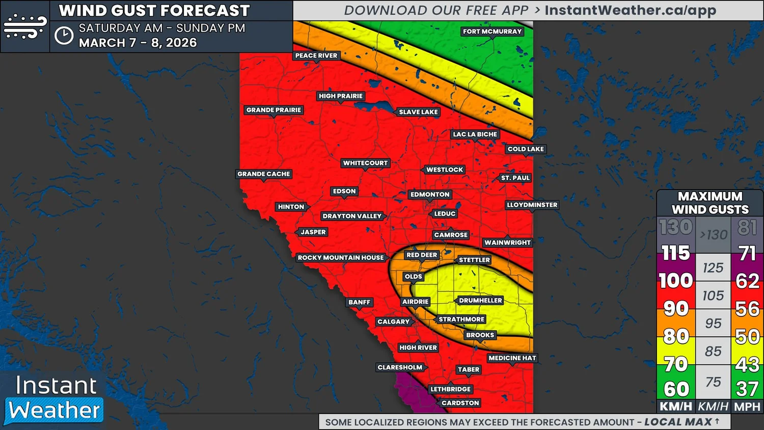
Wickedly Windy Weekend in Store Across Alberta, Widespread Gusts up to 100km/h
/
NOTE: if you click or tap on this image you can zoom in
It’s going to be a blustery weekend across Alberta, with strong wind gusts in excess of 70km/h expected at some point over the next two days for most of the province. These strong winds will strike in two rounds as two separate systems are slated to track through the Prairies this weekend.
The first system will begin to make its way into Northern Alberta Friday evening. it will bring a mixture of snow, rain, and freezing rain to the region overnight and through Saturday morning.
This system won’t bring too much snow to the area; a maximum of 5-10cm is expected and this will be isolated more to the Northeast. As far as freezing rain is concerned, it will be patchy and occur south of where the snow will fall. Total accretion will be limited to 1-2mm, but this will still be enough for untreated surfaces to become slippery.
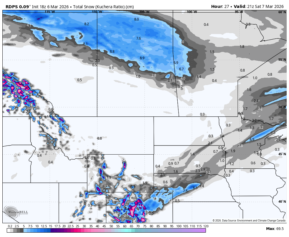
The rdps model showing total snowfall as of 2pm mt on Saturday. courtesy of WeatherBell.
To the south of the passage of this system, it’s a completely different story. High temperatures on Saturday are expected to be well above seasonal throughout Central and Southern Alberta, climbing into the double digits and maybe approaching the 20°C mark closer to the US border.
The first round of strong winds will also be found south of the system that will be tracking through Northern Alberta. The winds will start to pick up overnight Friday and peak Saturday morning. Wind gusts of 70-90km/h are expected through the Foothills and stretching across the width of the province to the north of Edmonton. Meanwhile, slightly weaker gusts, in the 50-70km/h range, will impact much of the rest of Central and Southern Alberta.
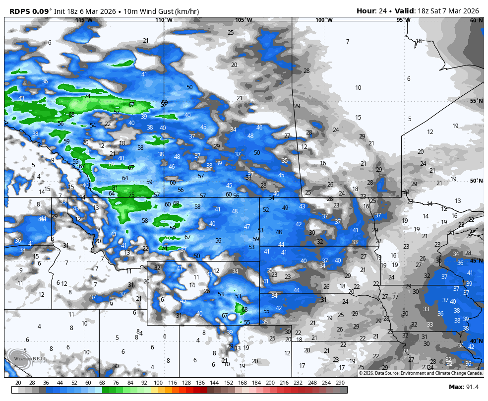
The rdps model showing showing wind gusts on Saturday at 11am mt. courtesy of WeatherBell.
This first round of strong winds will start to die down in the afternoon and evening for most of the province. However, the gusts will remain strong throughout the Rockies and communities closer to the International border. Beyond these areas, things will become calm for a few hours before the second system begins to make its way into the province later Saturday evening.
This second system is also expected to move through Northern Alberta, but it will track slightly to the south. Once again, snow is expected to fall across a swath of Northern Alberta crosses through the region from Saturday evening to Sunday evening, with models suggesting that up to 20cm could fall.
The winds are expected to be even stronger on Sunday as the cold front associated with the second system pushes southward and also leads to much cooler temperatures across most of the province. The winds will ramp back up Saturday evening and continue into Sunday afternoon before things start to quieten down in the evening. Widespread gusts up to 100km/h are likely during this time and gusts exceeding 100km/h can be also expected in Southwest Alberta.
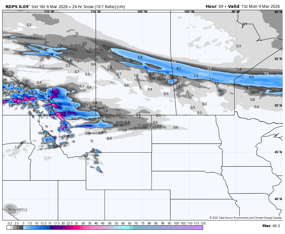
The rdps model showing 24 hour snowfall amounts as of 9am mt on Monday. courtesy of WeatherBell.
The end of the strong winds won’t be the end of active weather for the weekend. Snow is expected to develop Sunday evening across the Southern Foothills, which will spread eastward into the early morning hours of Monday before dissipating. Around 5-15cm of snow can be expected by lunchtime on Monday from Olds to the Montana border.