


Multiple Rounds of Severe Thunderstorms Expected Across Southern Ontario on Monday
/
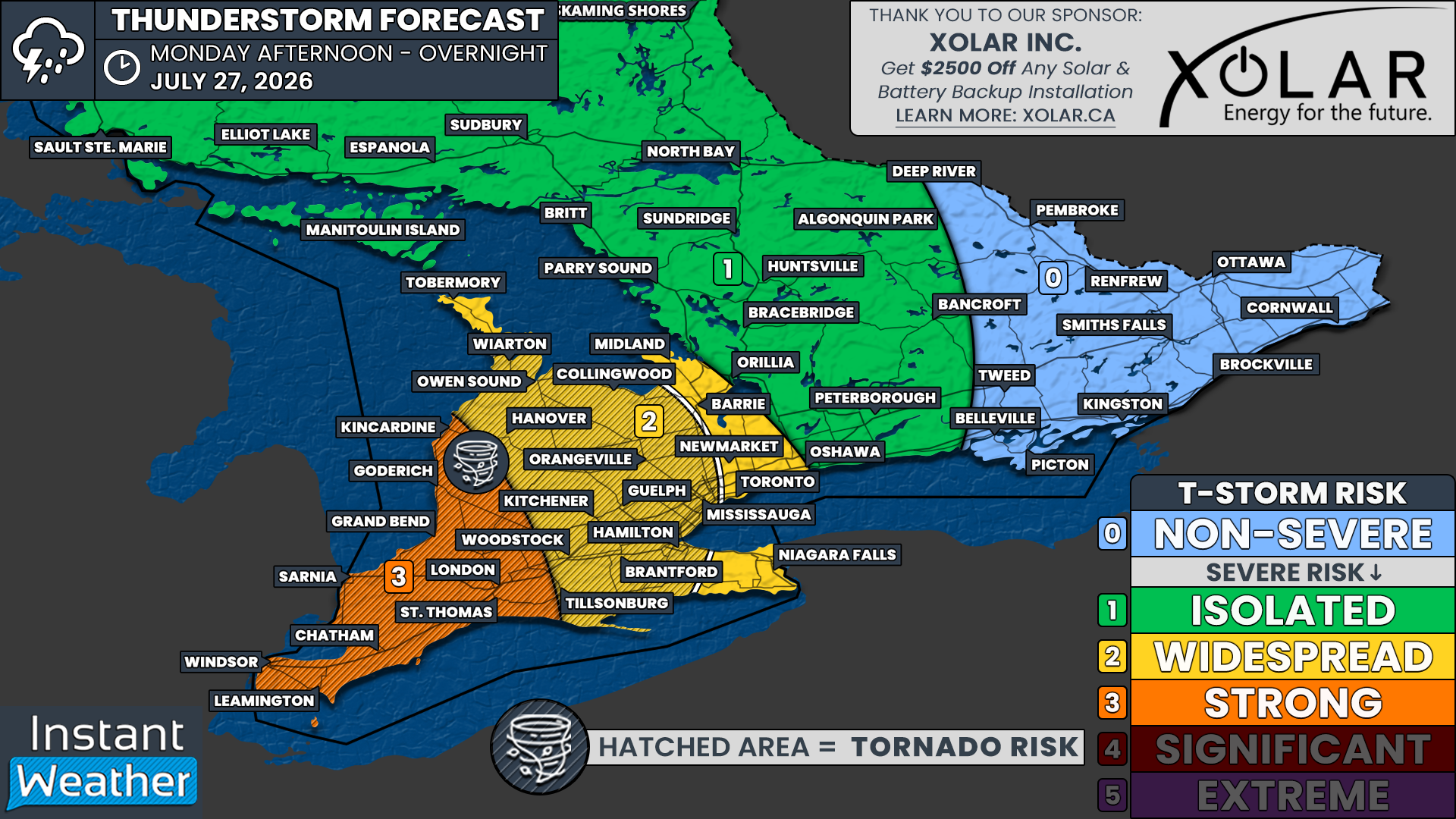
NOTE: YOU CAN CLICK ON THE MAP TO OPEN A ZOOMABLE IMAGE
After a relatively quiet stretch of weather, Southern Ontario is heading into a much more active pattern on Monday as multiple rounds of thunderstorms threaten a wide swath of the province. Some of these storms could become severe, bringing the risk of damaging wind gusts, large hail and the potential for one or two tornadoes.
The first round of storms has already developed early this afternoon, with a cluster of thunderstorms producing damaging wind gusts as they tracked inland from Lake Huron into parts of the London area. While this initial activity is ongoing, it is only the beginning of what could become a busy weather day across Southern Ontario.
Additional thunderstorms are expected to develop through the afternoon across Southwestern Ontario before spreading into portions of Central Ontario, particularly around the Lake Simcoe region. Exactly where these storms form remains uncertain, as forecast models continue to struggle with pinpointing the locations where new storms will develop.
Track the storms with us on YouTube
The severe weather threat is expected to continue through the afternoon and early evening, when daytime heating will provide the greatest amount of energy for storm development. Storms may continue well into the evening and persist into the early overnight hours, although the overall severe threat should gradually diminish after midnight as the atmosphere begins to stabilize.
Periods of rain and embedded thunderstorms are expected to linger into Tuesday morning before the system finally begins to move out of the region. Another round of potentially severe storms could affect Eastern Ontario on Tuesday afternoon.
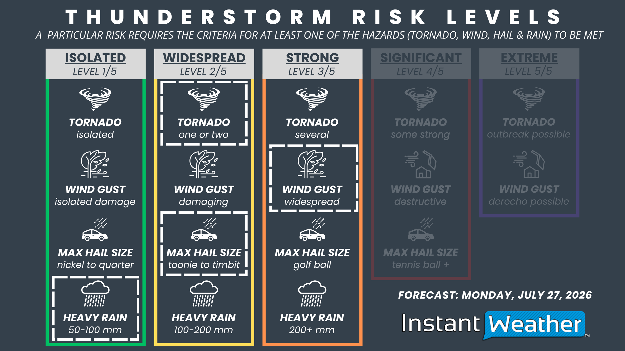
NOTE: YOU CAN CLICK ON THE GRAPHIC TO OPEN A ZOOMABLE IMAGE

The greatest concern remains across Deep Southwestern Ontario and communities along the Lake Huron shoreline, including Goderich, Sarnia, London, Chatham, Leamington and Windsor.
We have placed this region under a ‘Strong’ severe weather risk. Storms that develop here will have the potential to produce widespread damaging wind gusts capable of downing trees and power lines, hail ranging from toonie-sized up to Timbit-sized, along with the possibility of one or two tornadoes. Torrential rainfall may also lead to localized flash flooding, particularly where multiple thunderstorms repeatedly move over the same communities in a short period of time.
Further north and east, a ‘Widespread’ severe risk stretches across much of Southern and Central Ontario, including Kitchener, Guelph, Hamilton, Toronto, Barrie, Niagara, Hanover, Collingwood and Owen Sound.
The primary threats in this region will be damaging wind gusts and hail up to the size of toonies. While the tornado risk is lower than in Southwestern Ontario, an isolated tornado cannot be completely ruled out if a storm is able to remain isolated and tap into the favourable atmospheric conditions.
An ‘Isolated’ severe weather risk covers the remainder of Central Ontario, including Peterborough, Muskoka, Parry Sound and Algonquin Park. This risk also extends into parts of Northeastern Ontario, including Sudbury and North Bay.
Only a few storms are expected to develop in these areas, but any storm that does form could still briefly reach severe limits with strong wind gusts, hail and frequent lightning.
Given the uncertainty surrounding exactly where storms will develop, everyone across Southern Ontario should keep a close eye on the forecast throughout the day. Conditions can change quickly, and warnings may be issued with little lead time once thunderstorms begin to intensify.
We’ll be tracking every storm as it develops with live coverage on our YouTube channel, along with real-time updates through the free Instant Weather app. If you live anywhere within the risk areas, now is a good time to make sure notifications are enabled so you can receive notifications the moment they are issued.



