More Severe Thunderstorms Likely Across Central & Southern Manitoba Saturday

NOTE: YOU CAN CLICK ON THE MAP TO OPEN A ZOOMABLE IMAGE

After some severe thunderstorms and tornado warnings yesterday, we’re looking a similar setup as yesterday. A trough will continue moving through the province and it is expected to trigger more severe thunderstorms today.

Severe thunderstorms have already begun to move through the Interlake Region this morning, which are expected to continue to strengthen as they travel eastward. The greatest severe thunderstorm threat, however, looks to start in the early to mid afternoon and continue into tonight.

The afternoon storms could develop across a large swath of Central and Southern Manitoba. However, there has been disagreement between weather models regarding where exactly these storms could occur and how strong they might become.

Some models are showing that storms could begin developing in the early afternoon through the Parkland Region and southward, into parts of Westman and to the west of the Red River Valley. The timing of the storm initiation in the south is also a bit uncertain, with models suggesting it could occur sometime between 1pm and 5pm. There is also the likelihood of additional storms crossing into the Parkland area from Saskatchewan in the early evening.

Simulated Radar from the NAM model showing the possible line of thunderstorms moving through the Red River Valley at 5PM CT, Courtesy of Weatherbell.
The storms that manage to form are expected to rapidly gain strength as they chart a course eastward across the province. They are likely to become supercells and could end up merging into a large line of severe thunderstorms through the afternoon.

These intense thunderstorms will have the potential to produce golf ball or larger hail, damaging wind gusts in excess of 100km/h, and possibly a tornado. The risk of a tornado is less than yesterday, but the possibility can not be completely ruled out. These are expected to be moisture-laden and slow-moving thunderstorms, so localized flooding is definitely a concern as well.
Thunderstorm activity will gradually dissipate through the late evening hours as they approach and cross into Ontario. The severe thunderstorm threat is expected to conclude across Manitoba by midnight.

Severe Weather Threat Extends Across the Prairies Friday with Strong Risk and Tornadoes Possible in Parts of Saskatchewan & Manitoba

NOTE: YOU CAN CLICK ON THE MAP TO OPEN A ZOOMABLE IMAGE

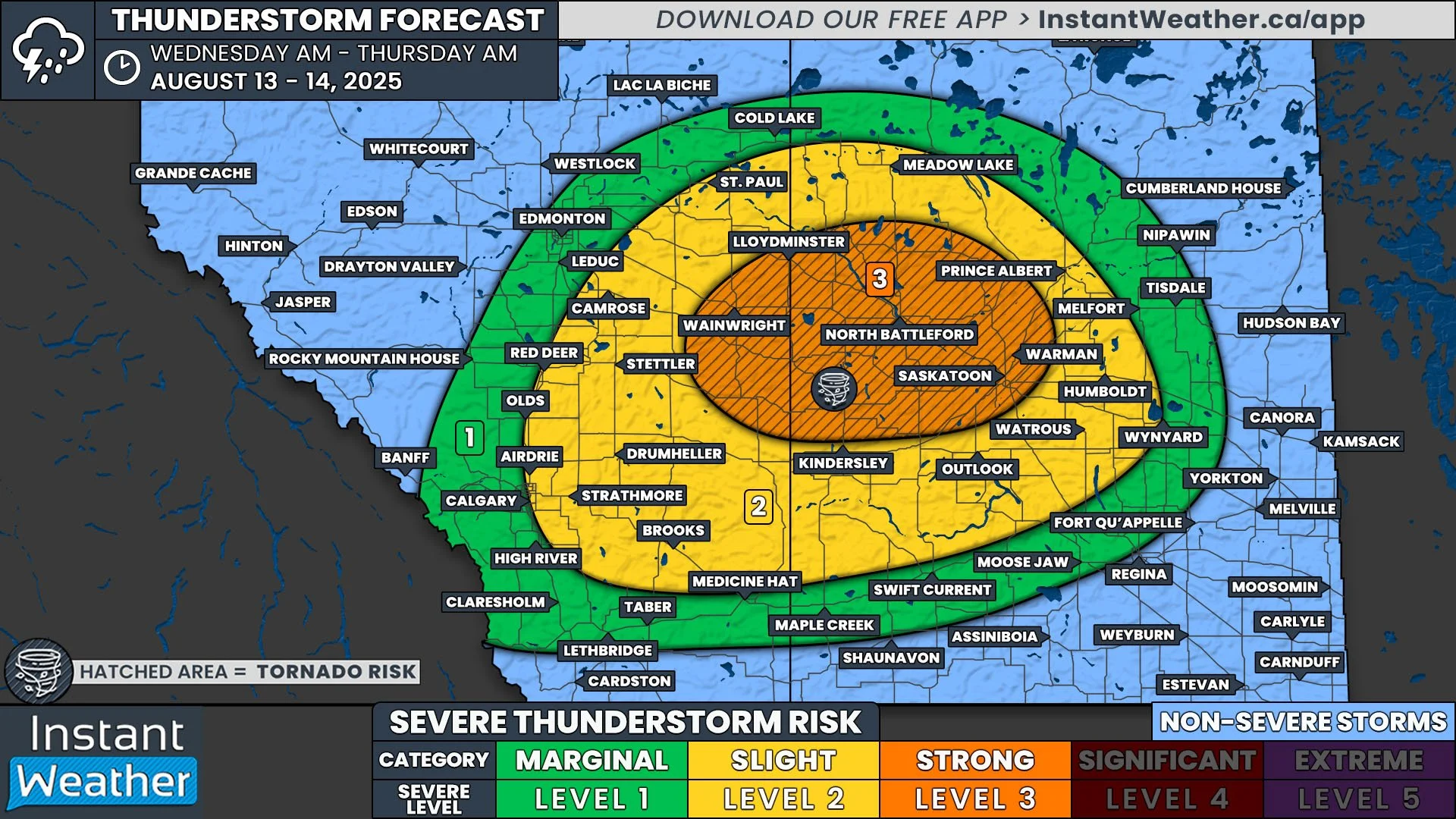
It’s shaping up to be an active day across the Prairies today, with severe thunderstorms possible across all three provinces. In fact, today brings the strongest severe weather risk we’ve seen all week.

Most of the thunderstorms expected across the region will likely remain marginally severe, stretching from the Foothills in Alberta to the Manitoba-Ontario border. However, the bullseye for the most intense storms is over Southeastern Saskatchewan and Southwestern Manitoba.

Thunderstorms are expected to kick off in parts of the Southern Foothills early this afternoon. These storms will track east-northeastward, and additional development is likely through the mid-afternoon along a broad arc stretching eastward across Central Saskatchewan and into Central Manitoba later in the evening.

These widespread storms should persist into the night across the Prairies, especially the further east you go. Some of these storms could become severe and produce nickel-sized hail, along with strong wind gusts. There is also a risk of localized flooding due to heavy rain from slow-moving or training thunderstorms.

In Alberta, conditions could be favourable for funnel clouds to form. While most of these remain harmless, there is a low chance that one or two could touch down briefly as a weak landspout tornado.

Simulated Radar from the HRRR model showing the arc of thunderstorms at 6pm MT/CST & 7PM CT, Courtesy of Weatherbell.
The greatest threat for severe weather today, however, will be to the south of the main batch of storms in Sakatchewan and Manitoba. The model image above shows these additional storms having already developed in the evening. Thunderstorm development in this more volatile area is expected to begin slightly earlier, around 3-5pm. Storms in this region will track eastward, while the southern edge of the cluster in Saskatchewan will likely expand south-southwestward toward the US border.

This area is forecast to encounter a highly supportive environment for severe storms in Southeastern Saskatchewan, with the possibility of storms to rapidly develop into supercell thunderstorms. Some isolated supercells could also initiate within this environment, along the Saskatchewan-Manitoba and into Southwestern Manitoba.

The highest risk area stretches from Carlyle, SK eastward through Brandon, MB, and north from the US border to the Foxwarren radar site. Storms moving through this area could become quite strong, with the potential to produce golf ball or larger hail, damaging wind gusts in excess of 100km/h, and possibly one or two tornadoes. Intense rainfall is also likely, making localized flooding a concern in this region as well.

Simulated Radar from the HRRR model showing thunderstorms in North Dakota, as well as in Saskatchewan & Manitoba at 9pm CST & 10PM CT, Courtesy of Weatherbell.

There are a couple of factors that might limit storm strength in this region. Lingering morning rain and cloud cover could reduce daytime heating, which would decrease the available energy for storm development. Additionally, an area of low-pressure that will track through North Dakota today may pull some of that energy south of the border, weakening the storms on the Canadian side.

Regardless of how strong the storms become, they are expected to track eastward throughout the evening and into the overnight hours. By the time they reach the Red River Valley after midnight, the storms should be quite weak and likely dissipate entirely not too long after.

Southern Ontario Faces Widespread Severe Threat Including Damaging Wind Gusts, Toonie-Sized Hail & Tornado Risk on Friday

NOTE: YOU CAN CLICK ON THE MAP TO OPEN A ZOOMABLE IMAGE

After Southern Ontario experienced some severe weather last weekend along with our first significant heat wave of the season, things have quieted down over the past few days. Milder air brought temperatures back to seasonal values on Wednesday and Thursday.

However, it looks like we’re about to heat up again heading into the weekend. The good news is, it won’t be anywhere near the oppressive heat we saw earlier this week.

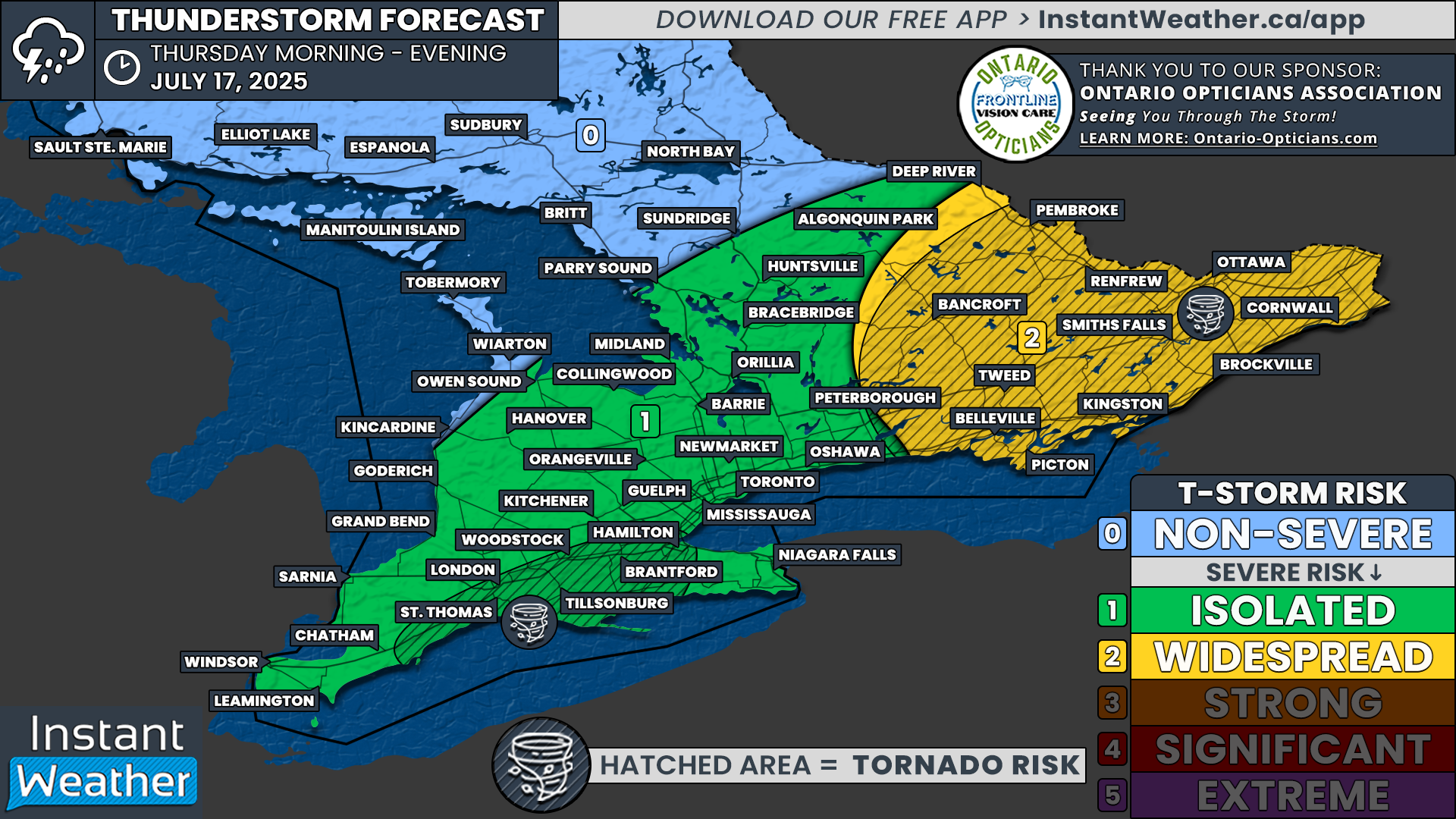
In addition to the return of summer warmth, there’s a growing risk of widespread severe storms on Friday. This threat covers much of Southwestern Ontario and stretches into parts of Central Ontario and the Golden Horseshoe.

Isolated thunderstorms are expected to fire up over Lake Huron and move into a very unstable environment during the afternoon, leading to the possibility of all severe weather hazards. This includes damaging wind gusts, large hail and potentially even one or two tornadoes.

As these storms push eastward into the evening hours, there’s a chance they could merge into one larger cluster of storms. This line may reach portions of the Greater Toronto Area and bring a continued threat of damaging winds, small hail and localized flash flooding.

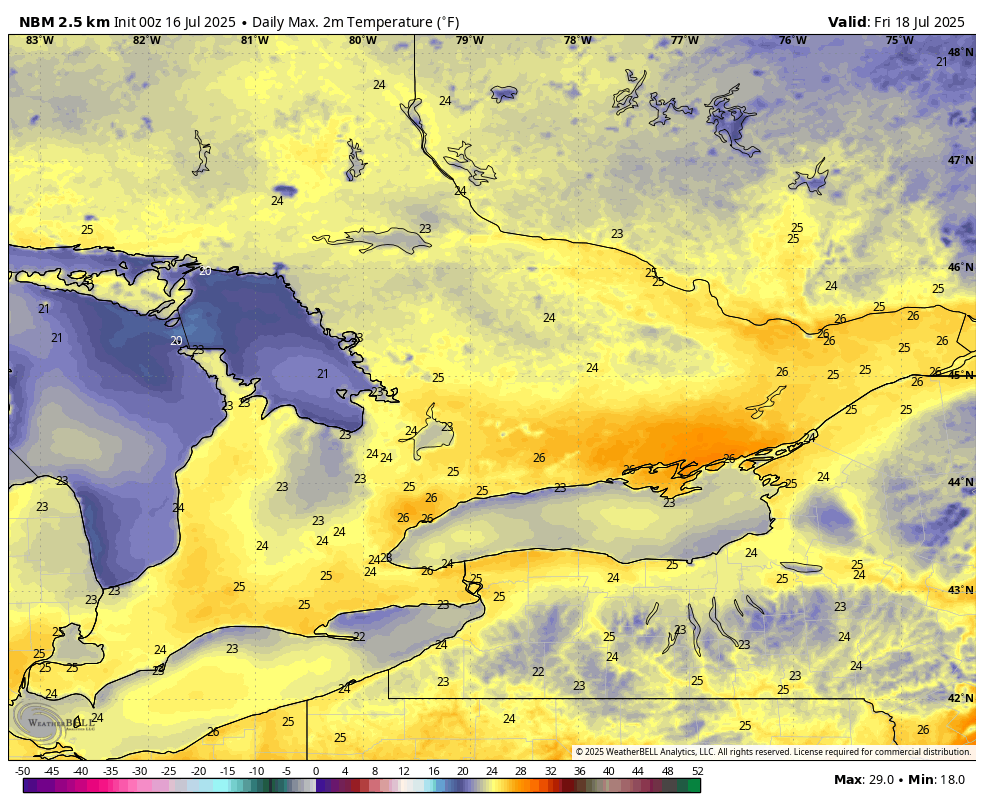
ESTIMATED DAYTIME HIGH in °C - MAP FROM WEATHERBELL

While the heat has pulled back across much of Southern Ontario over the past few days (except for Deep Southwestern Ontario), we’re expecting it to return on Friday. Areas south of Lake Simcoe will likely see daytime highs climb back into the upper 20s and even low to mid-30s across parts of Southwestern Ontario.

This won’t be the same level of heat we saw earlier in the week, but it will be a noticeable jump compared to the cooler air on Thursday that kept many places under 20°C for most of the day.

Once you factor in the humidity, some parts of Deep Southwestern Ontario could be feeling close to the upper 30s again.

SIMULATED RADAR - MAP FROM WEATHERBELL

As we often see on days with elevated storm risk, the morning could bring some scattered showers or thunderstorms near Lake Huron and Georgian Bay. These are not expected to be severe, but they will play an important role in shaping the setup for later in the day.

If the morning rain and storms linger longer than expected, they could limit afternoon storm development by preventing the atmosphere from fully recovering. This could reduce the strength or delay the timing of any severe storms into the evening when conditions aren’t quite as favourable.

There’s also some disagreement in the forecast models about how far south this morning precipitation might extend, especially in the zone where the severe risk is currently expected to be the highest.

SIMULATED RADAR - MAP FROM WEATHERBELL

If the atmosphere is able to recover in time, we could see isolated storms begin to fire over Lake Huron as early as mid-afternoon (2 to 4 PM), then track inland toward Grey, Bruce and Huron counties.

There’s still some uncertainty on the exact placement of this development. Storms could form anywhere along a corridor stretching from Manitoulin Island all the way down to Sarnia.

ESTIMATED ENVIRONMENT FOR TORNADOES - MAP FROM WEATHERBELL

As these cells develop over Lake Huron, they’ll be moving into a rapidly strengthening environment. Current model data suggests the highest tornado potential may be from Goderich to Owen Sound around 3-5 PM.

This region could see the greatest risk for severe weather during the mid to late afternoon hours. Storms that remain isolated early on may evolve into supercells capable of producing damaging wind gusts, large hail and a tornado or two.

While this particular setup leans more toward Southwestern Ontario, other models point to a similarly strong environment farther northeast into Central Ontario. This includes areas around Lake Simcoe, as well as parts of Simcoe County, Muskoka and the Kawartha Lakes.

SIMULATED RADAR - MAP FROM WEATHERBELL

As the storms push eastward during the late afternoon, current data suggests they may merge into one larger cluster of storms by the time they reach Central Ontario and then move into the Greater Toronto Area during the early evening.

At that point, the tornado threat will decrease, but the risk of damaging winds will become the dominant threat. This is typical when storms evolve into more linear systems.

Flash flooding could also become a major concern, especially in urban areas like the GTA, which are more prone to poor drainage. Some forecast models even suggest that this line could stall or ‘train’ over the same area, which would bring the potential for very heavy rainfall in a short amount of time.

The overall severe threat should begin to wind down between 9 and 10 PM as the sun sets and daytime heating fades. That said, the storm cluster may continue eastward into the Niagara Region and parts of Eastern Ontario overnight, though it’s expected to be non-severe by then.

As mentioned, the highest severe threat will likely be in the mid to late afternoon over Southwestern Ontario, especially as storms come ashore from Lake Huron.

These storms could bring damaging wind gusts, hail up to the size of toonies and possibly one or two tornadoes. The tornado risk would be greatest shortly after the storms reach land and should taper off farther inland.

Deep Southwestern Ontario might also see a few isolated storms develop during the afternoon, though the environment doesn’t look quite as favourable compared to areas farther north.

Still, any storms that do form here could bring isolated damaging wind gusts, quarter-sized hail and even a low-end tornado risk that can’t be ruled out.

As the storms move into Central Ontario later in the day, the primary risk will transition to damaging winds. The threat of hail and tornadoes will decrease, but a few storms could still produce quarter-sized hail and, again, an isolated tornado remains possible.

There’s also the potential for some isolated development around Georgian Bay and Lake Simcoe in the afternoon. If that happens, it could boost the tornado and hail risk across that region.

By the time the line of storms reaches the Golden Horseshoe, it will likely be starting to weaken. However, it could still bring the potential for isolated wind damage, nickel-sized hail and maybe a brief tornado, though that risk becomes increasingly unlikely at that point.

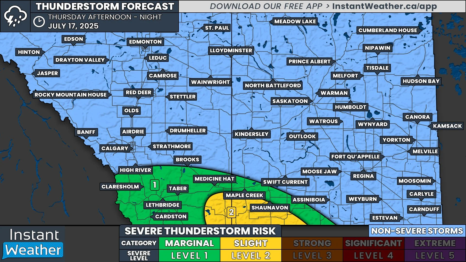
Risk for Severe Thunderstorms Continues in Saskatchewan Thursday Along with Torndao Threat

NOTE: YOU CAN CLICK ON THE MAP TO OPEN A ZOOMABLE IMAGE

The same low pressure system and warm front that triggered the development of severe storms and multiple tornado warnings yesterday will continue to impact parts of Saskatchewan today. The same severe thunderstorm risk also exists today, but the difference is that there is now a secondary area of low pressure that has built up along the preexisting warm front and a cold front is trailing not too far behind. This means that today’s severe thunderstorm threat is further east than yesterday, and it does not extend quite as far northward.

Despite this, thunderstorms are still expected to once again develop along the length of the warm front, stretching approximately from Saskatoon through Regina and into the US, as the front continues to cross the province today. As with yesterday’s setup, it is looking likely that the thunderstorms today will start off as isolated cells in the mid to late afternoon, around 2-4pm, with a majority of them then merging into northeastward travelling multicellular lines later in the afternoon and through the evening.

The thunderstorms are anticipated to quickly surpass the severe threshold in the late afternoon, with the greatest severe threat expected in the early evening. Today’s severe thunderstorms, much like yesterday, will have the potential to create large hail, which could be as large as golf balls, damaging wind gusts up to 110km/h, and possibly an embedded tornado. At this point, it appears that the tornado risk is lower than yesterday, but the potential still exists. Environment Canada has highlighted around Regina and areas to the northeast, in particular, as a region where the strongest of today’s severe thunderstorms could impact.

Today’s storms are expected to weaken later in the evening, but there is a chance that they could remain severe as they continue tracking northeastward into Manitoba overnight. Futhermore, there could be some stray thunderstorms that develop a bit further west, behind the main line, throughout the evening. These storms will likely be weaker, with the preceding storms taking a lot of energy out of the environment. Nevertheless, they will have the potential to become severe, especially as the storms ahead of them lose strength.

Widespread Risk of Severe Thunderstorms for Saskatchewan & Alberta Wednesday with the Risk of a Tornado

NOTE: YOU CAN CLICK ON THE MAP TO OPEN A ZOOMABLE IMAGE

A widespread risk of severe thunderstorms returns to Saskatchewan today with the arrival of a low pressure system that will track through the region. A warm front that will extend from the low is expected to trigger severe thunderstorms beginning this afternoon and continuing into overnight. The greatest risk for severe storms stretches from parts of Central Alberta through a large swatch of Central and Southern Saskatchewan, but there is also a chance for thunderstorms developing in the Foothills, which could become severe.

Thunderstorm development in the Foothills is expected to begin shortly after the lunch hour as isolated cells with further development possible throughout the afternoon and into the late evening. These isolated storms could have the potential to strengthen into severe supercell thunderstorms as they travel east-northeastward. The QE2 corridor between Red Deer and Calgary, in particular, could end up seeing some severe thunderstorms throughout the afternoon and evening, with the possibility of toonie-sized hail and wind gusts up to 90km/h.

Simulated Radar from the HRRR model showing 6pm CST, Courtesy of Weatherbell.

The thunderstorms further east, on the other hand, have a much greater chance of becoming severe, along with greater overall threats. As the warm front moves through the region, it is anticipated to trigger the development of severe thunderstorms along its entire length. This could begin as early as around noon, with storms continuing straight through into the overnight hours as the front tracks northeastward across Saskatchewan. The thunderstorms are expected to weaken later in the evening in the eastern half of the province, but there is the chance that the odd storm could maintain severe strength overnight.

One specific area that we will be monitoring will be along the Alberta border north to the Lloydminster and North Battleford area and from there, southeast to Regina. This is where the strongest of the storms will likely occur, which could possibly develop hail as large as golf balls, wind gusts in excess of 100km/h and potentially a tornado or two.

Isolated Severe Thunderstorms Could Hit Parts of Alberta Tuesday with Possible Timbit-Sized Hail & Strong Winds

NOTE: YOU CAN CLICK ON THE MAP TO OPEN A ZOOMABLE IMAGE

Isolated thunderstorms are possible across parts of Southern and Central Alberta today. A majority of these storms are expected to be non-severe, but there is chance for severe storms to develop through the QE2 corridor, from Red Deer to almost Cardston. The storms will likely form into multicell clusters, but there is the possibility of a supercell or two developing.

Thunderstorm activity is expected to start in the late afternoon, around 3-5pm, through the Foothills. The storms could become severe for the remainder of the afternoon and into the evening, as they make their way eastward, especially in the aforementioned corridor to the south of Red Deer. As we get closer to midnight, the thunderstorms are expected to gradually weaken and become sub-severe as they continue towards Saskatchewan overnight.

The main risks from today’s thunderstorms, if they do end up becoming severe, are hail that could be as large as Timbits and strong wind gusts up to 90km/h. Furthermore, the chance of a tornado forming from these storms is low, but can not be ruled out in the event of supercell thunderstorms developing.

Simulated Radar from the HRRR model showing 8pm MT, Courtesy of Weatherbell.

Severe Thunderstorms Possible in Parts of Manitoba Tuesday with Risk of Large Hail & Strong Winds

NOTE: YOU CAN CLICK ON THE MAP TO OPEN A ZOOMABLE IMAGE

Scattered severe thunderstorms are possible across parts of Southern and Central Manitoba today as a low pressure system moves through the region. Daytime heating will build the energy for these storms and for them to likely become severe beginning later in the afternoon and into the evening.

Thunderstorm activity is expected to start in the late afternoon, around 3-5pm, particularly in the North Eastman region, but also in Eastman. The storms will likely become severe and will persist for a few hours in the region as they travel eastward into Ontario.

Simulated Radar from the HRRR model showing 7pm CT and storms missing Winnipeg, Courtesy of Weatherbell.

There is some disagreement between short-term weather models, but it is possible that severe thunderstorms could also develop stretching southwestward into the Red River Valley at roughly the same time. On the other hand, this development could end up beginning slightly later, around 6pm. In the second scenario, it’s possible that storms could form closer to the US border, resulting in Winnipeg getting missed by the severe weather.

The main risks from today’s severe thunderstorms are hail that could be as large as ping pong balls and strong wind gusts up to 90km/h. The chance of a tornado forming from these storms is low.

Southern Ontario to Kick Off Summer This Weekend With Significant Severe Risk and Tornado Threat on Saturday; Sizzling Heat Near 40°C on Sunday

NOTE: YOU CAN CLICK ON THE MAP TO OPEN A ZOOMABLE IMAGE

Summer officially arrived late Friday night with the summer solstice, and it looks like Mother Nature isn’t wasting any time making it feel like summer across Southern Ontario. A multi-day heat wave is on the way, bringing the potential for record-breaking temperatures starting Sunday and continuing into early next week.

But before the heat sets in, we’re looking at what could easily be our strongest and most widespread severe weather threat of the season so far on Saturday. There are a lot of factors at play that make this a classic ‘boom or bust’ setup, which we’ll break down below.

There’s high confidence in a potent storm environment stretching across much of Southern Ontario. The big wildcard, however, is whether storms will actually develop to take advantage of all that energy. If they do, they could bring very large hail, destructive wind gusts, and possibly even a couple of tornadoes.

What’s especially concerning is that the storm environment doesn’t fade away after sunset like it typically does. In fact, it remains quite strong through the overnight and into Sunday morning, which could support a nocturnal line of storms with widespread damaging wind potential.

Once the severe risk passes, intense heat begins to build. Temperatures will soar well into the 30s by Sunday, with humidex values making it feel closer to the 40s. The heat continues Monday and Tuesday, with some relief expected midweek. That said, it’ll likely stay warm into the end of June and possibly early July.

A key ingredient in Saturday’s severe weather threat is already unfolding over North Dakota early Saturday morning. An intense line of storms, known as a “derecho” (a fast-moving complex of severe thunderstorms that can produce widespread wind damage), is sweeping through the northern Plains.

This system is producing destructive wind gusts of over 150 km/h along with several tornadoes and has already left damage in its wake. It’s expected to continue tracking eastward into the Great Lakes region through the day.

SIMULATED RADAR - MAP FROM WEATHERBELL

So what does that mean for Southern Ontario?

Derechos are known to travel long distances, and current model guidance suggests this one could follow a path toward Northeastern Ontario. Areas near the U.S. border, including Sault Ste. Marie and Elliot Lake, could be affected by the remnants of this system Sunday morning.

There’s still some uncertainty around how strong the system will be by the time it reaches Ontario. Forecast models often struggle with capturing the evolution and intensity of derechos, so the possibility that this one is being underestimated shouldn’t be ignored.

SIMULATED RADAR - MAP FROM WEATHERBELL

The projected track of what’s left of this potentially decaying derecho places it crossing Lake Huron and Georgian Bay into Central Ontario sometime Saturday afternoon.

If it maintains strength, it could bring damaging wind gusts, hail up to the size of toonies and maybe even an isolated tornado. But this could just be the first of multiple storm rounds.

Some models are also hinting at additional isolated storm development around Elliot Lake and Sudbury in the wake of the earlier line. That suggests the atmosphere could quickly recharge, although it’s still unclear how widespread any new storms would be.

ESTIMATED ENVIRONMENT FOR TORNADOES - MAP FROM WEATHERBELL

As we move into the late afternoon and evening hours on Saturday, the storm environment really ramps up. One of the key indicators we look at, the Significant Tornado Parameter, is literally off the charts in some areas, particularly near the Lake Huron shoreline and into Georgian Bay.

Here’s the catch, though: storms need to develop in this environment to take advantage of it. If they do, they could rapidly become severe, with the potential for all hazards. That includes large hail (possibly golf ball-sized or bigger), destructive winds over 100 km/h, and tornadoes.

SIMULATED RADAR - MAP FROM WEATHERBELL

Looking at what one model is simulating, there’s a notable lack of storms in the highest risk areas around Lake Huron. Instead, storms appear to fire up along a line from Sudbury to Parry Sound through Muskoka, just northeast of the most primed environment. These storms could still be strong and bring similar hazards.

It’s worth noting that models may be underdoing storm development in Southwestern Ontario. That’s something we’ll need to monitor in real time. If nothing happens in Southwestern Ontario, it could end up being a ‘bust’ - which would be good news for those who aren’t fans of severe storms.

ESTIMATED ENVIRONMENT FOR TORNADOES - MAP FROM WEATHERBELL

Typically, severe weather threats wind down after sunset as daytime heating fades. But in this case, models are suggesting the environment will remain unusually supportive of storm activity well into the overnight hours and early Sunday.

There’s even the potential that a new line of storms forms north of Georgian Bay and sweeps southeast through Southern Ontario overnight. If this happens, it could evolve into another derecho-type system - similar to the one seen Friday night in North Dakota.

Forecasting derechos is notoriously difficult, as models often fail to capture their full strength and endurance. While nothing is certain, this setup definitely has the ingredients to support a nocturnal derecho-type event.

If this scenario plays out, we could see widespread wind damage across Central and Eastern Ontario, possibly extending into parts of Southwestern Ontario and the Golden Horseshoe.

NOTE: YOU CAN CLICK ON THE MAP TO OPEN A ZOOMABLE IMAGE

This is a very tricky forecast, and while we've gone with a ‘significant’ (level 4 out of 5) risk, that doesn’t mean everyone will see storms. The risk will come in waves, and some areas may be completely missed.

That said, the potential severity of any storms that do form justifies this level of concern. We’re talking about the possibility of golf ball-sized hail or larger, destructive wind gusts (possibly from a derecho), and a few tornadoes. The tornado risk will largely depend on storm structure—more linear setups will favour damaging wind, while discrete supercells could increase the tornado threat.

The highest severe risk covers areas around Georgian Bay including Sault Ste. Marie, Elliot Lake, Manitoulin Island, Britt, and into Central Ontario such as Muskoka, Simcoe County and Bancroft.

A broader ‘strong’ risk zone includes much of Central and Eastern Ontario, the northern portions of Southwestern Ontario, and the Greater Toronto Area.

Meanwhile, areas like London, Kitchener, Hamilton and the Niagara region fall into the widespread severe risk category.

For once, Deep Southwestern Ontario may dodge the worst of the storms. Windsor, Chatham and Sarnia are currently in the isolated severe risk zone. While a stray storm can’t be ruled out, most of that region looks to stay quiet Saturday.

There may be another round of severe weather on Sunday afternoon and evening, but confidence in the details is still low. Eastern Ontario may be favoured, but we’ll refine that forecast once Saturday plays out.

NOTE: YOU CAN CLICK ON THE MAP TO OPEN A ZOOMABLE IMAGE

Sunday marks the beginning of an extended stretch of dangerously hot temperatures. The most intense heat is expected across Deep Southwestern Ontario into the Golden Horseshoe.

Areas like Windsor, Sarnia, London, Hamilton, Kitchener and Toronto could see daytime highs between 35°C and 40°C. With humidity, it will feel like the mid-40s in many spots.

Locations near Lake Ontario, Lake Erie, Lake Huron and Georgian Bay will be 5 to 10 degrees cooler, but it doesn’t take much distance inland to hit the oppressive heat.

Elsewhere in Southern Ontario, expect highs in the low to mid-30s with humidex values near 40°C.

Heat Safety Tips:

  • Stay hydrated and avoid strenuous outdoor activity during peak heat hours.

  • Check in on vulnerable individuals, including the elderly, young children and those with health conditions.

  • Never leave pets or people in parked vehicles.

  • Use fans or air conditioning when possible and find shade or cooling centres if needed.

SOURCE: ECCC

There’s a good chance many locations will break temperature records going as far back as the 1800s over the next few days.

According to Environment Canada, record highs in cities like Toronto, Windsor, Ottawa, London and Hamilton are in the mid to upper 30s for Sunday, Monday and Tuesday. Based on the current forecast, some of these records may fall.

NOTE: YOU CAN CLICK ON THE MAP TO OPEN A ZOOMABLE IMAGE

Monday brings more of the same, with extreme heat expanding into parts of Central and Eastern Ontario in addition to Southwestern Ontario and the GTA.

Once again, humidex values will push into the 40s, making it feel extremely uncomfortable and even dangerous for some.

Tuesday will still be hot, but may be slightly cooler compared to Monday. Some relief is on the way by Wednesday, although temperatures will likely stay warm overall.

Strong Severe Thunderstorm Risk Once Again on Thursday Targeting Saskatchewan and Manitoba with a Heightened Tornado Threat

NOTE: YOU CAN CLICK ON THE MAP TO OPEN A ZOOMABLE IMAGE

Severe weather is once again in the forecast for today, with a Strong severe thunderstorm risk for parts of Saskatchewan and Manitoba. The storms today will be triggered by a low pressure system that crossed into Saskatchewan from Alberta overnight. Heat and humidity will build throughout the day in Eastern Saskatchewan and Southwestern Manitoba, so by the time the low moves into this region later on, the environment will be primed for strong severe thunderstorm development.

There have been some scattered showers and non-severe thunderstorms in Central Saskatchewan already today, which should clear up in the early and mid-afternoon. Then, later this afternoon, isolated severe thunderstorms are expected to start to develop from Saskatoon and into Eastern Saskatchewan, at around 3-5pm.

Simulated Radar from the HRRR model showing 6pm CST/7pm CT, Courtesy of Weatherbell.

The storms could start off strong, particularly the ones that develop in the Saskatoon area, and are expected to strengthen further as they travel eastward, likely becoming supercellular in nature. Severe thunderstorms from Eastern Saskatchewan could move into Southwestern Manitoba as early as 4pm local time, but most models are suggesting this likely won’t happen until after 7pm. These storms will gradually lose strength after a few hours as they move through the region, becoming sub-severe by midnight.

The thunderstorms that develop closer to the American border could end up travelling along a southeasterly trajectory, which would limit the impacts of the storms from reaching the Red River Valley and Winnipeg area. There is the possibility, however, of a storm or two developing along the provincial border later in the evening which could eventually hit Winnipeg overnight as a sub-severe thunderstorm.

Simulated Radar from the NAM model showing 1am CT, Courtesy of Weatherbell.

Development that initiates in the Saskatoon area will eventually cross into Central Manitoba, likely shortly after midnight, but at this point the severe risk should be diminished and the main threat will be heavy rain associated with some strong wind gusts.

The strong severe weather threat today extends from east of Saskatoon southeastward into Manitoba and into North Dakota. The severe thunderstorms in this area could end up producing hail that’s larger than golf balls, wind gusts exceeding 100km/h, and possibly a tornado.

The greatest risk for these impacts, however, is expected to be in areas along the Saskatchewan/Manitoba border. A corridor that stretches from Yorkton, Saskatchewan to Virden, Manitoba has been specifically highlighted by Environment Canada as an area where the environment will be conducive to the development of one or two tornadoes today.

Severe Storms Target Southwestern Ontario Wednesday with Tornado and Damaging Wind Risk

NOTE: YOU CAN CLICK ON THE MAP TO OPEN A ZOOMABLE IMAGE

Storm season has certainly gotten off to a slow start in Southern Ontario, to say the least. Aside from a few scattered events earlier in the spring, it’s been a fairly quiet lead-up to summer across the region.

However, that’s about to change in a big way. As we approach the summer solstice on Friday, which marks the official start of summer, the pattern is shifting. Warmer temperatures and a more active storm pattern are setting the stage for what looks like a much stormier stretch of weather.

Wednesday’s setup will feature an environment that becomes increasingly favourable for storm development through the day. The main focus will be across Southwestern Ontario and into parts of the Golden Horseshoe during the afternoon and evening hours.

While the storms will likely start off isolated and scattered, they are likely to move quite slowly. This raises the potential for localized flooding, especially in areas that see multiple rounds of heavy rainfall from training storms.

A few storms could also produce near-severe wind gusts and small hail, particularly during the late afternoon and early evening. While not every area will be affected, those that are could see some very heavy rainfall over a short period of time.

The greater concern comes later in the day for Deep Southwestern Ontario, where a more potent setup could take shape.

Storms are expected to develop over Michigan during the afternoon and early evening. As these storms intensify, they may track eastward and cross into Ontario during the evening. Areas such as Windsor, Chatham, and Sarnia could be in the path of these stronger cells.

These storms will be moving into a more unstable environment that could support damaging wind gusts, quarter-sized hail, and potentially even an isolated tornado.

While confidence in storm development across the border is high, the extent of the severe threat in Ontario will depend heavily on the exact timing of when those storms cross into the province.

ESTIMATED AIR TEMPERATURE - MAP FROM WEATHERBELL

Before the storms arrive, temperatures will be on the rise across much of Southern Ontario. Afternoon highs are expected to reach the mid to upper 20s across Southwestern Ontario and into the Golden Horseshoe by early afternoon.

Central and Eastern Ontario will be a bit cooler, with highs ranging from the low to mid-20s. The Ottawa Valley could end up a touch warmer than the surrounding areas.

SIMULATED RADAR - MAP FROM WEATHERBELL

This heat and humidity will act as fuel for thunderstorm development, especially around Lake Huron and into areas near Lake Simcoe by the afternoon. Models vary on how widespread storm activity will be, with some showing scattered pop-up storms and others hinting at a more organized cluster.

Either way, any storms that do develop will be slow-moving, and locations underneath these cells could see multiple rounds of rainfall. That’s where the flood threat becomes more concerning, especially in urban areas that are more prone to flash flooding.

For much of the region, flooding will remain the primary concern. However, a few stronger storms could bring near-severe wind gusts and hail up to nickel size.

SIMULATED RADAR - MAP FROM WEATHERBELL

By the evening, our attention will turn stateside, where strong to severe storms are expected to organize over Michigan.

These storms are forecast to cross into Deep Southwestern Ontario sometime during the evening. The atmospheric setup in that region will support damaging wind gusts, hail up to the size of quarters, and the potential for a tornado.

Again, the timing will be critical. If these storms arrive before sunset, they’ll have access to better instability and surface heating, making them more capable of becoming severe. However, if they hold off until later in the night, the lack of daylight heating could limit their intensity.

ESTIMATED ENVIRONMENT FOR TORNADOES - MAP FROM WEATHERBELL

Models are currently showing a narrow window between 6 and 9 PM where the tornado potential could materialize, particularly around Windsor, Leamington, and Chatham. This will depend on how quickly storms move eastward from Michigan and whether they interact with the more favourable environment before it begins to weaken.

Once the sun sets, the tornado threat should diminish quickly, though some thunderstorm activity may continue through the night into early Thursday morning.

While a few non-severe thunderstorms may linger overnight, the severe threat will likely taper off before midnight.

As it stands, the highest risk for severe weather on Wednesday will be focused on Deep Southwestern Ontario, including Windsor, Leamington, Chatham, and Sarnia, with the window for impactful storms likely between 3 PM and midnight.

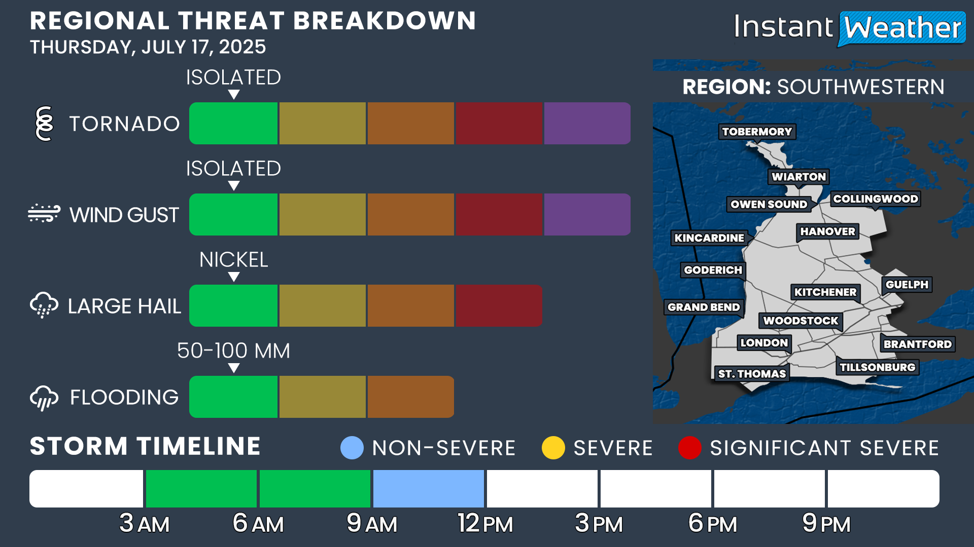
We’ve placed this region under a Level 2 (Widespread) risk due to the potential for damaging wind gusts and one or two tornadoes. Up to quarter-sized hail and locally up ot 50-100mm of rain is also possible.

Elsewhere across Southwestern Ontario and into the Golden Horseshoe, we’ve gone with a Level 1 (Isolated) risk.

This lower tier is mainly for flooding concerns, as slow-moving storms could drop significant rainfall over the same areas during the afternoon and early evening.

Some locations could also see isolated severe wind gusts, nickel-sized hail, and a very low tornado risk (confined mainly to parts of Southwestern Ontario).

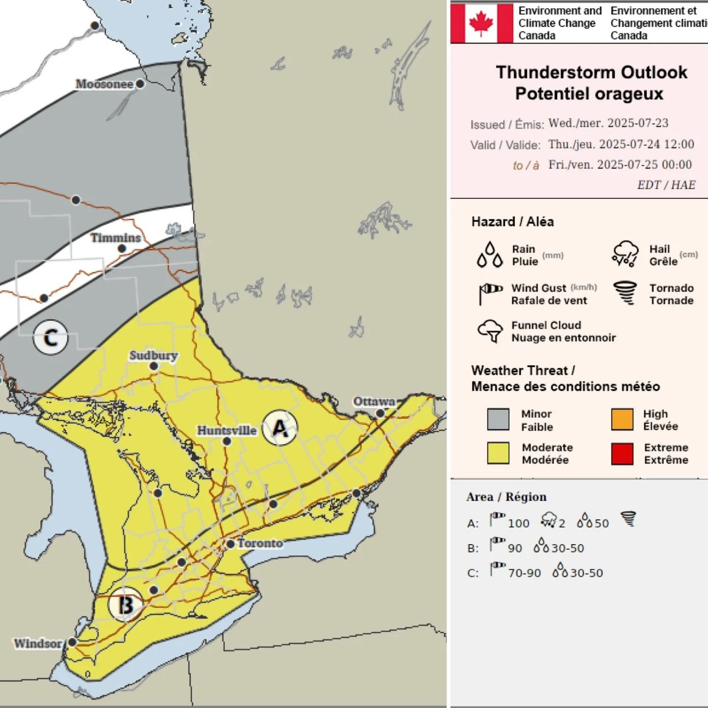
Environment Canada Forecasting Severe Storm Risk Wednesday for Parts of the Prairies with Large Hail, Damaging Winds, and Flooding Threat

Environment canada Forecast for Wednesday, June 18th issued Tuesday afternoon

Environment Canada has issued its preliminary Thunderstorm Outlook for tomorrow afternoon, forecasting a Moderate threat across different parts of the Prairies. These storms will be triggered by a cold front associated with a low pressure system that will sink southward through the Prairies from the Arctic over the course of the day.

Central and Southern Manitoba and into Southeast and East Central Saskatchewan comprise the “A” area, covering from Regina eastward through Manitoba to the Ontario border. In this region, Environment Canada is forecasting that severe thunderstorms could bring up wind gusts up to 90km/h, hail as large as toonies, and 20-30mm of heavy rain.

To the west, area “B” covers Southwest and West Central Saskatchewan. In this region, Environment Canada is forecasting weaker storms here than to the east, with the main risks being wind gusts of 70-90km/h and up to nickel-sized hail.

The strongest severe weather threat in this forecast is in area “D”, located in Central and Southern Alberta. The main risks from the storms in this region, according to Environment, are wind gusts up to 110km/h, hail as large as billiards balls, and 25-50mm of heavy rain.

Surrounding these three main areas with Moderate threats is area “C” with Minor threat. Environment Canada is forecasting that this large area could see storms that have wind gusts up to 70km/h and pea-sized hail.

Widespread Risk of Severe Thunderstorms Across Alberta & Saskatchewan on Tuesday Could Bring Timbit-Sized Hail and Damaging Gusts Over 100km/h

NOTE: YOU CAN CLICK ON THE MAP TO OPEN A ZOOMABLE IMAGE

There is a widespread threat of severe thunderstorms in both Alberta and Saskatchewan today that are expected to be stronger than yesterday’s scattered pop-up storms.

The storms are expected to develop early this afternoon, around 12-2pm, across both Central and Northern Alberta and Saskatchewan, as well as through the Foothills. The storms in the northern regions of both provinces should stay sub-severe, but the environment to the south of Edmonton and North Battleford/Saskatoon will be much more conducive to the storms surpassing the threshold of becoming severe.

These thunderstorms will start off as individual cells, but look to become more organized into multicellular clusters as they strengthen, travelling eastward and southeastward across Alberta and Saskatchewan through the afternoon and into the evening. However, it is possible that the odd storm could develop into an isolated supercell. The thunderstorms in this region will be capable of producing large hail, up to the size of a Timbit, as well as strong wind gusts approaching 100km/h and heavy downpours that could lead to some localized flooding.

There will be an additional area of severe thunderstorm development beginning in Southeastern Alberta in the early to mid afternoon, in the 1-3pm time-frame, which will cross into Southwestern Saskatchewan by 3-5pm. These storms are also expected to become larger multicellular clusters, which could produce some slightly smaller, nickel-sized hail and heavy rain, but the greatest concern will be widespread damaging wind gusts in excess of 100km/h.

The greatest wind threat is expected to occur in Southwestern Saskatchewan, through Maple Creek, Shaunavon, and Swift Current, from the late afternoon and into the evening. The intense winds could reach as far east as Moose Jaw and Regina after 10pm, though, as the storms continue tracking eastward. There is some uncertainty with this as storms across both Alberta and Saskatchewan are expected to lose intensity after sunset and they could be sub-severe by the time they reach the Regina area. Nevertheless, we have extended our Slight risk eastward to cover this possibility.

The chance of a tornado developing from today’s storms is low, but as usual, it can not be completely ruled out with severe thunderstorms.

Possibility for Severe Weather Continues for Alberta with Isolated Severe Thunderstorms Bringing Heavy Rain, Strong Winds, and Hail on Monday

NOTE: YOU CAN CLICK ON THE MAP TO OPEN A ZOOMABLE IMAGE

Our stretch of active weather continues today with the risk of some isolated severe storms this afternoon and evening across Alberta. We are not looking at a situation where storms are large and widespread, but rather, a large area could see the odd pop-up thunderstorm today.

The storms are expected to develop early this afternoon, around 12-2pm, in Central and parts of Northern Alberta, mostly from Edmonton and northward. The likelihood of development increases eastward and a greater number of small storms are expected in the eastern half of the region.

The severe threat diminishes to the north of Slave Lake and Lac La Biche, so those northward of these areas can expect non-severe thunderstorms or heavy rain showers throughout the day. The threat also diminishes later into the evening so severe thunderstorms that develop this afternoon and evening will eventually become sub-severe as they track southeastward.

A bit later in the afternoon, beginning around 3-5pm, additional isolated thunderstorms are expected to develop east of the Rockies. These storms are also expected to be isolated as they progress eastward through the remainder of the afternoon and into the evening. They should lose a majority of their energy later in the evening, leading to some scattered showers continuing in some parts of Central and Southern Alberta overnight.

The thunderstorms today, while likely becoming severe, are not anticipated to be as severe as the storms we’ve seen in Alberta over the past couple of days. Nonetheless, these severe storms will have the potential to deliver heavy downpours with localized flooding, strong wind gusts of up to 90km/h, and fairly large hail which could be as large as your standard Timbit. The environment does not appear to be conducive to the development of funnel clouds or tornadoes today, but a touch down can never be completely ruled out with severe weather.

Stronger Risk for Severe Thunderstorms for Friday in Alberta & Saskatchewan Which Could Bring Damaging Winds, Large Hail, and Possibly a Tornado

NOTE: YOU CAN CLICK ON THE MAP TO OPEN A ZOOMABLE IMAGE

While yesterday’s storms didn’t quite cross the threshold of becoming severe, the chances for severe thunderstorms are much greater for today, as a low pressure system moves through Central Alberta. Areas north of the low, into Northern Alberta, can expect widespread rain today as the system tracks eastward, with up to 20mm falling, and an additional 20mm is possible on the backside of the system through the day tomorrow. Around the low and southward, however, severe thunderstorms are expected to dominate the afternoon and continue into the evening and overnight hours.

Isolated thunderstorms could start to develop as early as the noon hour, but the bulk of the storms are anticipated to begin in the mid-afternoon, around 2-3pm, and continue into the evening across Central and Southern Alberta as the low and its associated warm front cross through the region. The storms triggered by this front are expected to be isolated, with the environment favourable for the development of supercells, so the activity won’t be as widespread as seen yesterday.

A bit later in the afternoon, there is also a slightly higher chance that storms in Southeastern Alberta could become severe as they cross into Saskatchewan. This will be dependent on the southerly winds clearing wildfire smoke out of the area so that daytime heating can be maximized ahead of the warm front. Storm activity could continue overnight through parts of Saskatchewan, but they are expected to quickly lose strength later in the evening so any remaining storms should be sub-severe.

Today’s severe thunderstorms could bring damaging wind gusts up to, and possibly exceeding, 100km/h, along with heavy downpours and hail as large as ping pong balls. In the East-Central region of Alberta, from Edmonton towards Lloydminster and southward to almost Red Deer, the environment will also be favourable for the development of funnel clouds and there is a slight chance of a tornado forming.

Fire danger map for June 12th produced by the government of Alberta

There has been a major decline in the fire hazard across most of Central and Southern Alberta with widespread rain over the past couple of days. That trend will continue into parts of Northern Alberta with the significant rain that is expected to fall to the north and on the backside of the low pressure system that will track across the province today.

The storms that could to move into Southwestern Saskatchewan later today may also start to lead to a downtrend in the fire danger in that area. We could possibly see this trend continue tomorrow as the system is expected to cross through Saskatchewan, bringing additional thunderstorm activity to the southern half of the province and widespread rain to the north of the low.

Isolated Risk for Severe Thunderstorms Thursday with Damaging Wind Gusts and Hail Possible

NOTE: YOU CAN CLICK ON THE MAP TO OPEN A ZOOMABLE IMAGE

After an extended period of dry conditions across Southern Alberta, aside from the odd pop-up shower or non-severe thunderstorm, we’re finally seeing that pattern change. More widespread rain finally returned to the region yesterday, which has continued into this morning. This afternoon, we can also expect to see the return of severe thunderstorms.

Thunderstorm activity is expected to kick off in the early afternoon, around 12-2pm, in the Foothills and northward, to the east of the Rockies. These storms will start off as isolated cells, but they could merge into larger clusters of storms as they gradually track northeastward through the afternoon.

Additional storms will follow in the evening, extending further south towards the US border. These storms could maintain their strength, if conditions remain favourable, as they end up tracking eastward across Southern Alberta overnight and into tomorrow morning. Otherwise, the region could just experience some moderate to heavy rainfall instead.

The greatest thunderstorm risk will be in the Southwest, stretching from Calgary southward to the US border and east through Taber. This region could see damaging wind gusts of up to 100km/h and large nickel to quarter-sized hail, along with torrential downpours. At this point, the threat of a tornado appears to be unlikely, but it can not be completely ruled out.

Fire danger map for June 12th produced by the government of Alberta

With the return of some rain, we’re also seeing a downtrend in the fire danger in Central and Southern Alberta. The arrival of more rain today, despite the presence of some lightning, will likely lead a continued decrease in the fire danger in Southern Alberta. The lightning could still spark additional fires in areas where the fire danger remains elevated so it’s important to watch for any new fire activity and to report it immediately if you see smoke.

Much Needed Rainfall is Finally on its Way for Most of Saskatchewan This Weekend

Model image showing total rain from friday morning until monday morning, courtesy of weatherbell

Good news Saskatchewan: there's finally rain in the forecast! The bad news is that not everyone will see the rain and strong winds could still be an issue.

To start, we've already seen some scattered showers across Northern Saskatchewan this morning. The rain is expected to continue through the day and into tomorrow, with some pushing into Central Saskatchewan this evening.

This precipitation will be associated with non-severe thunderstorms, like we've seen for most of the week, which could bring strong wind gusts up to 70km/h and possibly small hail. Luckily though, these storms will finally bring a decent amount of precipitation.

Environment Canada forecast for friday afternoon

Early tomorrow morning, light rain will cross through Southern Saskatchewan. Then, in the afternoon, the rain from the north will push southeastward as it wraps around a low pressure system moving south from the Territories.

The rain is expected to fall in in Eastern Saskatchewan through Sunday morning and afternoon, dissipating in the evening and leading to much less rainfall in the Southwest than in the rest of the province. Aside from this region, widespread 10-50mm is expected by the end of Sunday. Luckily, the areas with the worst fires can expect a decent amount of rain this weekend.

Unfortunately, strong wind gusts up to 70km/h are expected to persist through the weekend and this could still pose a challenge for firefighting efforts despite the precipitation and cooler temperatures.

Warm Temperatures Briefly Return With Isolated Severe Thunderstorm Risk for Southern Ontario Wednesday

NOTE: YOU CAN CLICK ON THE MAP TO OPEN A ZOOMABLE IMAGE

While much of late May across Southern Ontario was dominated by unseasonably cool weather, the start of June is shaping up to be a very different story. Over the past few days, temperatures have rebounded to near-seasonal levels across the region, and that’s just a preview of what’s ahead. But enjoy it while you can because a noticeable cool down is expected later this week.

This early June heat has also arrived with a layer of upper-level smoke drifting in from wildfires burning across Western Canada. This smoke has caused a light haze in the sky, giving the air a faint smoky smell, dimming the sun, and slightly suppressing daytime temperatures compared to what we would have seen under clear skies.

The good news is that much of this smoke is expected to clear out across Southern Ontario overnight into early Wednesday morning. While some lingering smoke may remain high up in the atmosphere, it shouldn’t be as thick or widespread as what we’ve seen over the past 36 hours.

With clearer skies, daytime heating will be more effective, giving temperatures a better shot at reaching their full potential. On Wednesday, we’re expecting highs to climb into the upper 20s and possibly even low 30s in some spots.

NOTE: YOU CAN CLICK ON THE MAP TO OPEN A ZOOMABLE IMAGE

A cold front sweeping across the province late Wednesday will bring a shift in the pattern, knocking temperatures back below seasonal for the latter half of the week. This front is also expected to trigger a line of thunderstorms, some of which may be marginally severe.

Primary threats include damaging wind gusts up to 90 km/h, pockets of quarter-sized hail, and localized flooding from slow-moving storms. There is also a very low risk of an isolated tornado, but given the weak storm environment, this threat is quite uncertain and likely limited.

ESTIMATED AIR TEMPERATURE - MAP FROM WEATHERBELL

Much of Wednesday will start off hot and hazy, especially across Southern Ontario. Temperatures will rapidly climb into the upper 20s by early afternoon ahead of the approaching cold front. In some areas, particularly Deep Southwestern Ontario, the Golden Horseshoe, and the Ottawa Valley, temperatures could push into the low 30s.

That said, locations along the immediate shorelines of the Great Lakes will likely remain a few degrees cooler due to the lake breeze. These areas, including communities along Lake Erie, Lake Ontario, Lake Huron, and Georgian Bay, should see highs closer to the low to mid-20s.

As the cold front begins moving in from the northwest, starting around 2 to 4 PM near the Bruce Peninsula and the North Bay and Parry Sound region, we’ll see an almost instant temperature drop. It could fall by as much as 10 to 15 degrees within a couple of hours. The front will then gradually push southeast through the rest of the afternoon and into the early evening hours.

As the temperatures rise, it’s crucial to keep our beloved pets safe and comfortable. Here are some essential tips to ensure your furry friends stay cool this summer:

🚗 Never Leave in Cars: Even with windows cracked, the temperature inside a car can rise dramatically in just a few minutes. On a 24°C day, the temperature inside a parked car can soar to 38°C in just 10 minutes. In 30 minutes, it can reach 49°C! Leaving your pet in a car can be deadly, so never leave them unattended.

If you see a pet left unattended in a car in Ontario:

  • Look for the Owner: Note the car's make, model, and license plate number. Go to nearby businesses to see if you can find the owner.

  • Call for Help: If you cannot find the owner, call your local animal control or police. You can call the OSPCA at 1-833-9-ANIMAL (264625). If you believe the animal is in immediate distress, call 911 immediately.

  • Stay with the Pet: Remain with the pet until help arrives.

🏡 Shade & Shelter: Make sure your pets have access to shaded areas to avoid direct sunlight. A cool, sheltered spot can make a big difference.

💧 Hydration is Key: Always provide fresh water for your pets. Dehydration can set in quickly, so keep their water bowl filled and in a shaded area.

🐕 Limit Exercise: Avoid walking your pets during the hottest parts of the day. Early morning or late evening walks are best to prevent overheating.

🐾 Paw Protection: Hot pavement can burn your pet's paws. Walk them on grass whenever possible, or use protective booties to shield their feet.

⚠️ Watch for Signs of Overheating: Symptoms include excessive panting, drooling, and lethargy. If you notice these signs, move your pet to a cooler area immediately and provide water.

UPPER LEVEL SMOKE CONCENTRATION - MAP FROM WEATHERBELL

Although the smoke won’t be nearly as thick as what we experienced Monday and Tuesday, some light to moderate upper-level smoke may still linger on Wednesday. Forecast models suggest the highest concentrations will likely be around the Golden Horseshoe, including the Greater Toronto Area, Hamilton, and the Niagara region.

There may still be a faint smoky smell in the air at times, but surface-level smoke isn’t expected to be heavy enough to significantly impact air quality. What it could do, however, is hold temperatures back by a couple of degrees in some spots since the sunlight won’t be able to fully break through the smoke layer.

By Thursday, most of this smoke should clear out completely. That said, some models are hinting at another round of wildfire smoke pushing into the region by late this week or into the weekend.

SIMULATED RADAR - MAP FROM WEATHERBELL

Along with cooler temperatures, the advancing cold front will bring the potential for thunderstorms across Southern Ontario. Current data suggests that a line of storms will begin forming early Wednesday afternoon, stretching from North Bay down into parts of Michigan.

NOTE: YOU CAN CLICK ON THE MAP TO OPEN A ZOOMABLE IMAGE

As this front continues to track southeastward, conditions will become more favourable for some of these storms to become locally severe. Isolated threats include damaging winds, large hail, and heavy downpours. The highest risk zone appears to be in a corridor running from Deep Southwestern Ontario through Kitchener and Waterloo, into the Lake Simcoe region, and extending northeast into the Algonquin Park area.

The timing for the strongest activity looks to fall between 3 PM and 6 PM, though it could stretch a bit later, especially in areas near the border. Some model runs even show a rogue thunderstorm crossing into the Windsor or Sarnia area from Michigan during the evening hours.

The overall tornado threat remains low due to the weak storm environment and expected messy storm mode, but it is never zero. Sometimes we do see surprise spin-up tornadoes in Ontario, especially where lake breezes collide and enhance low-level rotation.

After sunset, the severe risk should wind down fairly quickly. However, a few non-severe thunderstorms may continue into the late evening and overnight as the front moves across the Golden Horseshoe and into Eastern Ontario.

Slight Risk for Isolated Severe Thunderstorms on Thursday with 100km/h Wind Gusts, 3cm Hail & Isolated Flooding Possible

NOTE: YOU CAN CLICK ON THE MAP TO OPEN A ZOOMABLE IMAGE

We’re closely monitoring a slight risk for isolated severe thunderstorms this afternoon and evening in parts of central Alberta. Areas such as Edmonton, Edson, Red Deer, Whitecourt, Leduc, Camrose, Rocky Mountain House, Drayton Valley, High Prairie, Slave Lake, Lac la Biche, Westlock, Hinton, Olds and surrounding communities may see these storms. However, as they’ll be isolated, most areas will not receive any precipitation at all.

Damaging wind gusts of 80-100km/h, 3cm hail and isolated flooding up to 50mm are the main risks for these storms. Of course, frequent lightning and torrential rain are also expected for those who are affected by these storms.

The overall tornado risk is low so chances of a spin-up are unlikely. However, we all know that stranger things have happen so definitely make sure to have our free app Instant Weather to get notified of any and all alerts from Environment Canada for your area.

Environment Canada has also issued Severe Thunderstorm Watches for the region, shown below.

NOTE: YOU CAN CLICK ON THE MAP TO OPEN A ZOOMABLE IMAGE

NOTE: YOU CAN CLICK ON THE MAP TO OPEN A ZOOMABLE IMAGE

Environment Canada writes:

”Conditions are favourable for the development of severe thunderstorms this afternoon and evening that may be capable of producing strong wind gusts and large hail.

Damage to roofs, fences, branches or soft shelters is possible. When thunder roars, go indoors! Lightning kills and injures canadians every year.

Severe thunderstorm watches are issued when conditions are favourable for the development of thunderstorms capable of producing damaging hail, wind or rain.”


In addition to the severe thunderstorm risk, the Fire Danger map for Alberta shown below is very concerning as almost all areas of Alberta are under “Extreme” fire danger.

Fire danger map for may 29th produced by the government of Alberta

With the expected lightning, warmer temperatures and drier conditions, it’s very possible we could see new wildfires ignited from these storms today. Please stay safe folks and we’ll post more updates when available.

Slight Risk for Severe Thunderstorms on Monday as a Cold Front Advances Through Alberta

NOTE: YOU CAN CLICK ON THE MAP TO OPEN A ZOOMABLE IMAGE

The past week was fairly quiet, as far as active weather is concerned, with the odd pop-up thunderstorm surpassing the severe threshold and a couple of funnel cloud reports. This week, however, is slated to start off with a bang as a cold front will move into Alberta later this afternoon, stretching the length of the province and triggering the development of thunderstorms over a widespread area.

We’ve already seen some scattered showers across parts of Central and Northern Alberta today, but the severe threat won’t begin until this afternoon, around 2-4pm. These will be fast-moving storms that will quickly develop and organize into a north-south line along the cold front as it crosses the province through the afternoon and evening. Storm activity will rapidly diminish as we get later into the evening, but isolated storms could continue until closer to midnight, if conditions remain favourable.

The greatest thunderstorm risk will stretch from Calgary northward up to Fort McMurray, highlighted in yellow on our map. This large region could see damaging wind gusts of up to 100km/h and large nickel to quarter-sized hail, along with torrential downpours. At this point, the threat of a tornado appears to be unlikely, but it can not be completely ruled out.

Fire danger map for may 26th produced by the government of Alberta

The amount of lightning associated with today’s storms could also be a concern. Warmer temperatures and drier conditions have elevated the wildfire risk over the past week and has led to High to Extreme Wildfire Danger across the entire province. Significant amounts of lightning, despite the presence of precipitation, could easily spark additional fires given these conditions.

Nocturnal Thunderstorm Threat With Damaging Wind Gusts and Isolated Tornado Risk for Southwestern Ontario Tonight

updated map - 10:50 PM (CLICK HERE FOR THE PREVIOUS MAP)

NOTE: YOU CAN CLICK ON THE MAP TO OPEN A ZOOMABLE IMAGE

UPDATE (10:50 PM):

We’ve been closely tracking the line of storms developing across Michigan, and it’s now set to move into Deep Southwestern Ontario over the next few hours.

Based on the latest model data, current environmental conditions, and how well the storm is holding together despite the lack of daylight heating, we believe there’s enough evidence to upgrade parts of Deep Southwestern Ontario to a ‘strong’ (3/5) risk—mainly due to the potential for intense wind gusts.

Large hail up to the size of toonies is also possible, and we can’t completely rule out an isolated tornado.

We’ve also extended the ‘slight’ (2/5) risk further inland to include areas like Goderich and London, as new data suggests the line could stay fairly strong as it tracks deeper into Southwestern Ontario during the pre-dawn hours. Again, damaging wind gusts remain the primary threat.

The line is expected to cross the border just after midnight, with the severe threat gradually tapering off but still continuing until around 3–4 AM.


ORIGINAL FORECAST

While storm season has had a quiet start in Southern Ontario, things are beginning to ramp up with a late-night storm risk expected between Thursday evening and early Friday morning. A strong line of storms is forecast to form across Michigan late tonight, initially beginning as discrete supercells over parts of Wisconsin and Illinois.

Based on the latest guidance, these storms are expected to organize into a more linear structure as they track eastward, eventually crossing into Southwestern Ontario sometime just after midnight. While they’ll likely lose some of their strength after dark, especially without daytime heating, the atmosphere may still be supportive enough for them to maintain some intensity as they move into our region.

That said, there’s still a fair amount of uncertainty about just how strong this line will be once it crosses the border, and how quickly it might weaken as it tracks northeast through the early morning hours of Friday.

The biggest concern with this system is the potential for damaging wind gusts. This squall line will stretch from the Upper Peninsula of Michigan all the way down through Ohio as it enters Ontario, which could lead to widespread impacts. Areas from the Bruce Peninsula all the way down to Deep Southwestern Ontario are at risk of strong winds embedded within the line.

The highest risk appears to be in Deep Southwestern Ontario, where the line will first cross into Ontario. Regions like Windsor, Leamington, Chatham, and Sarnia are most likely to experience the strongest part of this line. While damaging wind gusts are the main hazard, we also can’t completely rule out the chance for hail and even a brief tornado, especially if the storms arrive a bit earlier than forecast.

Hail up to the size of quarters is possible, and while the tornado risk is considered low overall, it does exist. The biggest concern here is that this is a nocturnal threat. If a tornado were to develop overnight, it would be harder to spot and could be rain-wrapped, making it even more dangerous. That’s why it’s so important to stay alert and have a way to receive warnings while you sleep.

SIMULATED RADAR - MAP FROM WEATHERBELL

Storm development will begin with discrete cells over Wisconsin and Illinois, likely forming into a long line around 8–10 PM near Chicago and across Lake Michigan.

The timing of this formation is crucial. If the line develops sooner and sweeps across Michigan quickly, it could result in a more robust severe risk for Deep Southwestern Ontario, where the environment is more favourable before midnight.

No matter the timing, damaging winds remain the most likely outcome with this type of linear storm setup.

SIMULATED RADAR - MAP FROM WEATHERBELL

As of now, future radar models suggest the storms will cross into Ontario between 1 and 2 AM, hitting areas like Windsor and Sarnia first before stretching further northeast. However, there’s still wiggle room in this timing. It could arrive earlier and stronger, or later and already weakening before reaching our region.

ESTIMATED TORNADO ENVIRONMENT - MAP FROM WEATHERBELL

While widespread wind damage is the primary concern tonight, there is some minor tornado potential—especially in Essex County just after midnight. Again, the odds are low, but not zero.

Because of the overnight timing, it's extra important to have notifications enabled on your phone or weather radio. Make sure you have a way to receive alerts while you're asleep in case a warning is issued. Our free app is a great way to instantly get Environment Canada alerts, along with our custom notifications issued for your exact location.

SIMULATED RADAR - MAP FROM WEATHERBELL

The line of storms is expected to continue northeast through the early morning hours, bringing heavy rain, gusty winds, and frequent lightning to much of Southwestern Ontario and parts of the Greater Toronto Area between 3 and 6 AM.

While the line should gradually weaken during this time, it could still pack a punch in some localized areas. There’s some uncertainty around how long it will be able to hold its strength since the atmospheric environment in Ontario is notably weaker than what the storms had access to in the U.S.

Latest model runs show the system likely fizzles out once it reaches Lake Simcoe, meaning Eastern and Central Ontario probably won’t see much beyond a few scattered morning showers or storms.

Another round of storms is possible Friday afternoon and evening, particularly for Eastern Ontario and parts of Deep Southwestern Ontario. We’ll have more details on that in a separate update.

As it stands, the highest storm risk tonight is in Deep Southwestern Ontario, where we currently have a slight risk (2/5) for severe weather. The main hazard is damaging wind gusts between 12 and 6 AM, though isolated tornadoes and hail up to the size of quarters are also possible.

For the rest of Southwestern Ontario and the Golden Horseshoe, the risk is lower—a marginal (1/5) severe threat—with isolated pockets of wind damage being the most likely outcome. There’s also a very low tornado risk along the Lake Huron shoreline as the line initially pushes into the region. Hail up to the size of nickels could accompany some of these storms.

In addition to the overnight threat, a few isolated pop-up storms are possible during the late afternoon and early evening across parts of Grey-Bruce. While these are not expected to be severe, funnel clouds are possible, including a low-end risk of a landspout tornado. See our custom notification for more on the funnel cloud setup.

Stay weather-aware tonight. Keep your devices charged, notifications turned on, and have a plan in place just in case you need to take shelter quickly. We’ll continue to monitor the latest data and provide updates as the situation evolves, including a possible live stream later tonight.