🌪️ ‘Tornado Tuesday’: Confidence Continues to Build For Significant Severe Thunderstorms Next Week in Ontario ⛈️
/
NOTE: YOU CAN CLICK ON THE MAP TO OPEN A ZOOMABLE IMAGE
TUESDAY, APRIL 29, 2025: Confidence continues to build for the risk of significant severe thunderstorms and tornado activity this Tuesday. Since our first article posted on Friday morning where we discussed this potential, we’ve continued to carefully monitor a strengthening trend on the forecast models. And at this point, we’re trending up from what initially looked like an Enhanced Risk (3/5), towards an isolated Significant Risk (4/5) based on the latest data. What we’re expecting at this point is isolated strong-to-significant severe thunderstorms across parts of Southwestern and Central Ontario Tuesday afternoon & evening that could possibly extend into the GTHA and parts of Eastern Ontario overnight, depending on the timing and speed of the cold front.
A lot can still change four days out but the consistency of the model data is why we here at InstantWeather have been discussing this for several days and why even Environment Canada has issued a preliminary forecast map today, discussing some of the risks on Tuesday including 100km/h damaging wind gusts and 2-4cm hail as you can see in the image below.

NOTE: YOU CAN CLICK ON THE MAP TO OPEN A ZOOMABLE IMAGE
Environment Canada, in their first forecast map for this event has not mentioned a tornado risk. This is likely because we’re four days out but based on the data that we’ll be reviewing below, we’d be very surprised if they did not add a tornado risk in their forecast update tomorrow. Along with this forecast map, they wrote:
”A cold front will track east across northeastern and southern Ontario. By the afternoon, severe thunderstorms may develop with the main threats being strong wind gusts and large hail.”

🔎Model Data Review

NOTE: YOU CAN CLICK ON THE MAP TO OPEN A ZOOMABLE IMAGE
In the image above, we’re looking at the latest “NAM” model data for 5pm on Tuesday and what we’re reviewing is the “Supercell Index”. This gives us an idea of how potent the environment is for rotating storms, which can lead to damaging wind gusts, large hail, flooding, intense lightning and in some cases, tornadoes. In our previous article, we only saw an orange supercell risk which is roughly an “Enhanced” risk level (3/5). However, in the latest data we are now seeing the colour red, which is hinting at the potential for a “Significant” risk level (4/5).
And in the image below, we see what the “Supercell Index” looks like at 8pm from the same “NAM” model, continuing the strong environment into the evening hours and extending it further into Eastern Ontario.


NOTE: YOU CAN CLICK ON THE MAP TO OPEN A ZOOMABLE IMAGE
It’s still quite early but we’re now finally getting some higher quality data from the NAM model at 12km resolution and what you’re seeing above is simulated or “Future Radar” of how the event might play out. It’s still quite early and this could certainly change but it’s interesting to watch it evolve day-by-day. With this model run, the storms start to develop on the Lake Huron shoreline near the Kincardine and Goderich areas around 5pm. We do see some development up by Britt as well around that time. Again, this is just estimated and we could see a new solution to how this plays out each and every day leading up to Tuesday.
NOTE: YOU CAN CLICK ON THE MAP TO OPEN A ZOOMABLE IMAGE
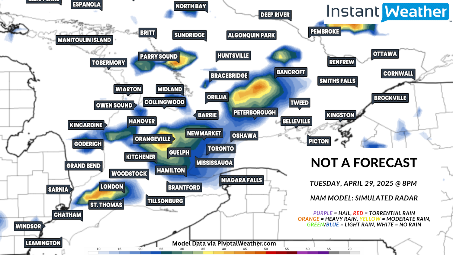
By 8pm in the image above, the simulated NAM future radar is suggesting we could see several potent supercells tracking through parts of Southwestern and Central Ontario. In previous model runs, we have seen a large line of storms as well, which in some cases can limit the tornado risk. Although, we could end up dealing with multi-cell supercells with an environment this strong and those can most certainly produce strong, isolated tornadoes.

NOTE: YOU CAN CLICK ON THE MAP TO OPEN A ZOOMABLE IMAGE
And in this potential scenario from the NAM model, we still the storms expanding and tracking through deep Southwestern Ontario, Central Ontario and perhaps into parts of Eastern Ontario by 11pm. Typically, the later in the evening we get, the less we daytime heating we have to increase the severity of these storms but with how strong this environment is, it could be a late night for many of us and we’ll certainly be livestreaming as long as it takes to ensure everyone stays informed and safe.
If you’d like to get notified when we start livestreaming, subscribe to our YouTube channel for free and hit the bell icon to get notified when we go live.
And to get notified of any rotation detected, funnel cloud reports, tornado reports and Environment Canada watches & warnings, download our free mobile app InstantWeather on your phone or tablet.
🤔Final Thoughts:
If this trend continues and this system does not decide to weaken all of the sudden (here’s hoping it does), Tuesday continues to look like a strong or potentially significant severe thunderstorm risk. All modes of severe weather could be on the table with damaging wind gusts, torrential rain, isolated flooding, large hail, intense lightning and the potential for isolated tornadoes, some of which could be strong. Here’s hoping that it weakens into a marginal risk or vanishes all together!
Having said that, please begin to review your storm safety plan and start discussing the potential for rescheduling your Tuesday afternoon/evening plans.
More details ASAP.
Disclaimer: By using our services and any associated content, this means you implicitly agree to use the services and data available as is with no warranty issued or implied and should be used for informational purposes only. Any use of this data for decision making processes is done at the sole risk of the end user. Do not reproduce or disseminate our forecasts and content without explicit consent of Instant Weather, Inc.


