First Strong Severe Thunderstorm Risk of the Season in Southern Ontario on Tuesday With Tornadoes Possible
/

NOTE: YOU CAN CLICK ON THE MAP TO OPEN A ZOOMABLE IMAGE
After a gruelling winter filled with relentless snow squalls, powerful winter storms, and a major ice storm to top it all off, we are finally shifting gears into more typical spring and summer-like weather across Southern Ontario. But with the warmer air comes the return of severe thunderstorms, something Southwestern Ontario has already gotten a small taste of over the past few weeks.
We have been closely tracking the potential for our first strong severe weather threat of the season on Tuesday. Model guidance has been consistently highlighting the potential for a very active environment, one capable of supporting tornadoes, large hail, and damaging wind gusts. That risk still looks to be on track, although there remains some disagreement between models on exactly where the strongest environment will set up.
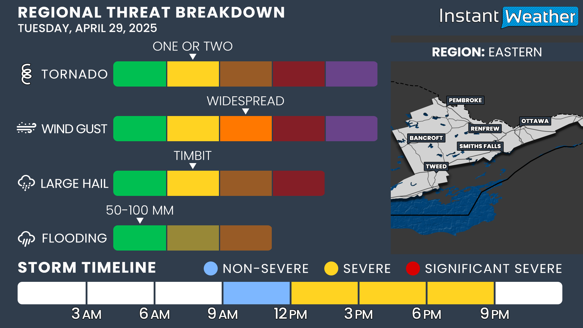
At this time, we believe the strongest severe weather risk will focus across parts of Southwestern Ontario, Central Ontario, and into Eastern Ontario. Other areas across Southern Ontario will still carry a marginal to slight risk, meaning a few severe storms could pop up, but the widespread threat will be lower outside the main zone.
Tuesday’s possible storm threats include one or two tornadoes, large hail — potentially up to the size of toonies or even timbits — widespread damaging wind gusts over 90-100 km/h, and heavy rainfall that could cause localized flooding in some spots.

The storm risk will kick off early Tuesday morning as an area of convection moves across the region between 6:00 a.m. and 12:00 p.m. Most of these morning storms should remain non-severe, but we can't rule out a rogue severe cell, especially in setups like this. Where these morning storms track and how quickly they clear out will be important to watch, as leftover clouds or rain could limit how unstable the atmosphere becomes later in the day.
By the early afternoon hours, the environment is expected to rapidly become more favorable for severe weather. Areas along the Lake Huron shoreline will likely be the first to feel the effects, with the risk then spreading into parts of Central Ontario.
Even though we are confident that the setup is capable of producing severe storms, it’s important to stress that storms actually have to form to take advantage of the environment. Not everyone in the higher-risk zone will necessarily see a storm. These will be isolated events, meaning only a small percentage of the region will be directly impacted.
The highest tornado risk will likely occur earlier in the day across Southwestern and Central Ontario, when individual storms (known as discrete supercells) can remain separated and feed off the prime environment around them.
As the afternoon progresses and storms track further eastward, we expect that they will start to merge into more of a line, which would shift the threat more towards damaging winds and heavy rain rather than tornadoes and large hail.
By late afternoon into early evening, the severe weather risk will push eastward into the Golden Horseshoe and Eastern Ontario. The good news is that the risk should wind down quickly after sunset, which occurs around 8:00 p.m.
There could still be some leftover showers or weak storms lingering into the evening, especially across Eastern Ontario, but the threat for damaging weather will rapidly diminish once the sun goes down.
We’ll continue to monitor this setup closely and provide updates as new data becomes available. Stay tuned, and as always, make sure you have a way to receive alerts if storms develop in your area.
Download our free app to instantly get any Environment Canada alerts and our own custom notifications pushed to your phone. We are planning to go live to cover any storms that develop throughout the day on Tuesday. Please subscribe to our YouTube channel here so you can be notified when we go live.
REGIONAL BREAKDOWN