White Christmas Locked In for Parts of Southern Ontario, While Others Face the Risk of a Green Christmas for 2025
/
NOTE: YOU CAN CLICK ON THE MAP TO OPEN A ZOOMABLE IMAGE
As the big day approaches this Thursday, many across Southern Ontario are starting to ask the big question. Will we wake up to that picture-perfect White Christmas, or will the Grinch sneak in at the last minute and snatch it away from right under our noses (and our carrots)?
In some parts of Southern Ontario, especially the snowbelt regions, it might feel like a White Christmas is already wrapped up and sitting under the tree. These areas were absolutely pummelled by relentless snow squalls earlier this month, leaving behind an impressive snowpack.
But for others, it has been a very different story. Some regions managed to dodge the worst of the snow so far this season, and whatever snow did fall has largely melted away thanks to a recent stretch of milder weather.
That sets the stage for a classic Christmas weather showdown. The Grinch, helped along by a few Heat Miser inspired temperature spikes, will try to erase what little snow remains. Jack Frost, however, is waiting in the wings and is expected to take over closer to Christmas. This makes a weak system expected Tuesday into Wednesday the key player, potentially delivering a last minute chance at a White Christmas for some areas.
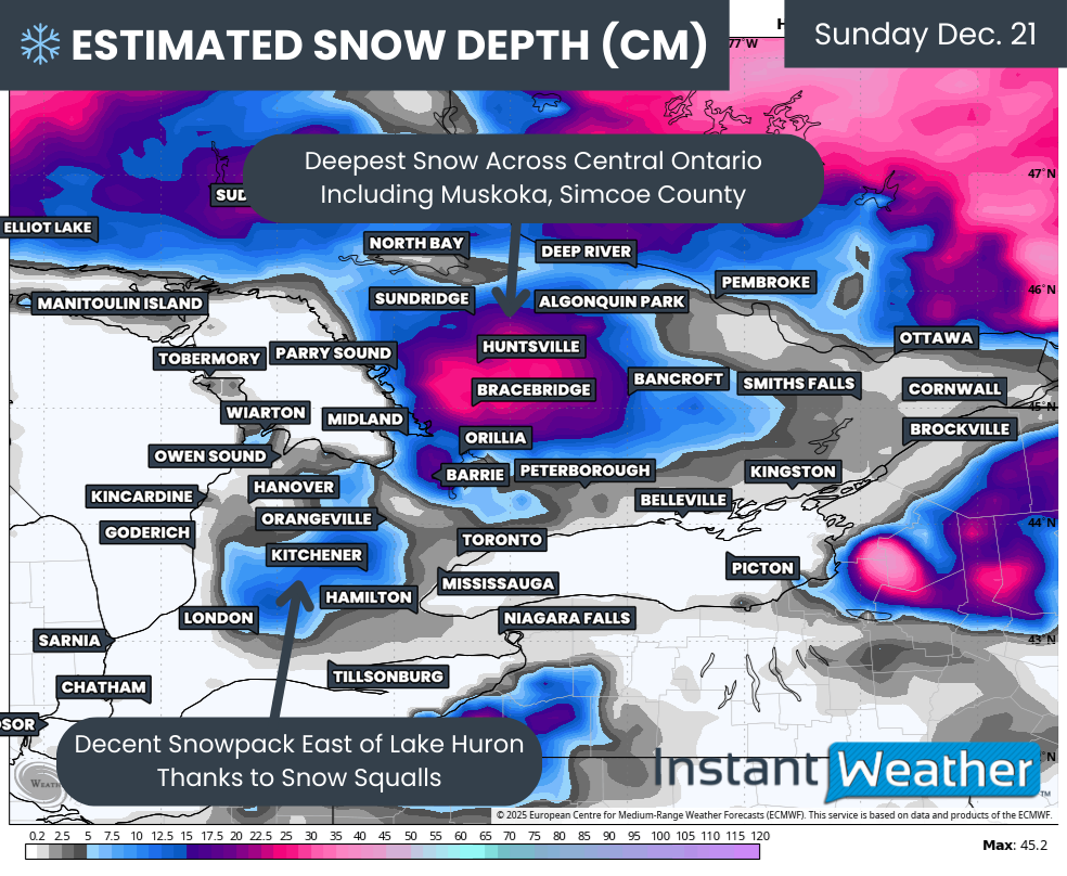
CURRENT SNOWFALL DEPTH (cm) - MAP FROM WEATHERBELL
We begin by looking at the existing snowpack, which is often the biggest clue in determining where a White Christmas is all but guaranteed. The most impressive snowpack is found east of Georgian Bay through Simcoe County and into Muskoka, Haliburton and Bancroft.
Model estimates suggest a solid 10 to 25cm of snow on the ground here. These models are fairly low resolution and likely underestimate reality, especially since much of this snow fell during intense lake effect events.
There is also a respectable snowpack of around 5 to 15cm in the higher elevations of Southwestern Ontario, particularly northeast of London. These areas have taken the brunt of snow squall activity several times already this month. Meanwhile, snowpack east of Lake Huron has been noticeably reduced by the recent mild spell.
Outside of those regions, there really is not much snowpack left that can meaningfully contribute to a White Christmas. This includes Deep Southwestern Ontario, the Niagara Region, much of the Golden Horseshoe and into Eastern Ontario, including the Ottawa Valley.
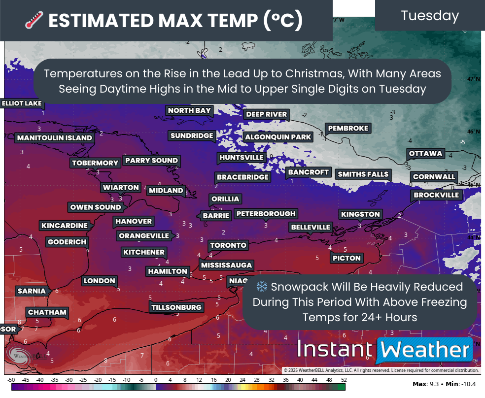
estimated max temp on tuesday - MAP FROM WEATHERBELL
The first challenge arrives early this week as temperatures steadily rise above freezing for more than 24 hours. The warmest day looks to be Tuesday, with daytime highs climbing above freezing across much of Southern Ontario, with the main exception being parts of the Ottawa Valley.
Some areas could even push into the mid to upper single digits, especially in Deep Southwestern Ontario and around the Golden Horseshoe. That is more than enough warmth to put a serious dent in any remaining snow.
Rain may also enter the picture early Tuesday in some areas. Combined with above-freezing temperatures, this will further erode minor snowpack. At that point, the only snow that is truly expected to survive is east of Georgian Bay. For many other areas, including east of Lake Huron, the final outcome will depend heavily on the last 36 hours leading up to Christmas morning.
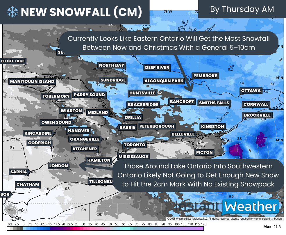
NEW SNOWFALL BY CHRISTMAS MORNING (cm) - MAP FROM WEATHERBELL
The system moving through on Tuesday is expected to bring light snowfall across Eastern Ontario. With temperatures expected to remain below freezing afterward, this snowfall should help lock in a White Christmas for the Ottawa area, even though there is currently very little snow on the ground. A general 5 to 10cm by Wednesday should be more than enough to tip the scales.
In Southwestern Ontario, however, the outlook is not as festive. Much of the snowfall associated with this system is expected to fall before temperatures rise and precipitation transitions to rain. Any snow that does fall will likely melt away quickly.
The one exception may be the higher elevations east of Lake Huron, where temperatures could hover near freezing just long enough for the snowpack to cling on until Christmas morning. Even there, it will be very close.
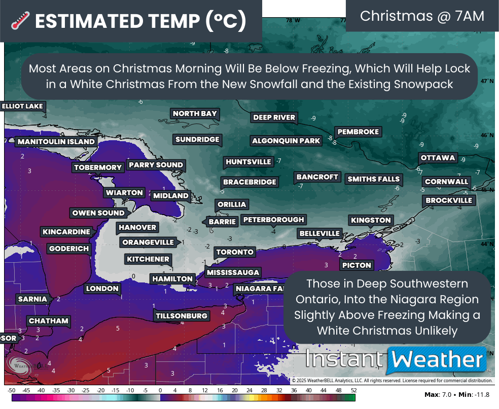
estimated temp on CHRISTMAS MORNING - MAP FROM WEATHERBELL
By Christmas morning itself, current indications suggest many across Southern Ontario will wake up to below freezing temperatures. That will help preserve whatever snow remains on the ground. This includes much of Central and Eastern Ontario, as well as higher elevations northwest of the GTA, such as Orangeville and Kitchener.
In Deep Southwestern Ontario and areas along the Lake Erie shoreline into parts of the GTA, temperatures are expected to be slightly above freezing. With very little existing snowpack to work with, those milder conditions are likely to melt away any lingering hope of a White Christmas.

NOTE: YOU CAN CLICK ON THE MAP TO OPEN A ZOOMABLE IMAGE

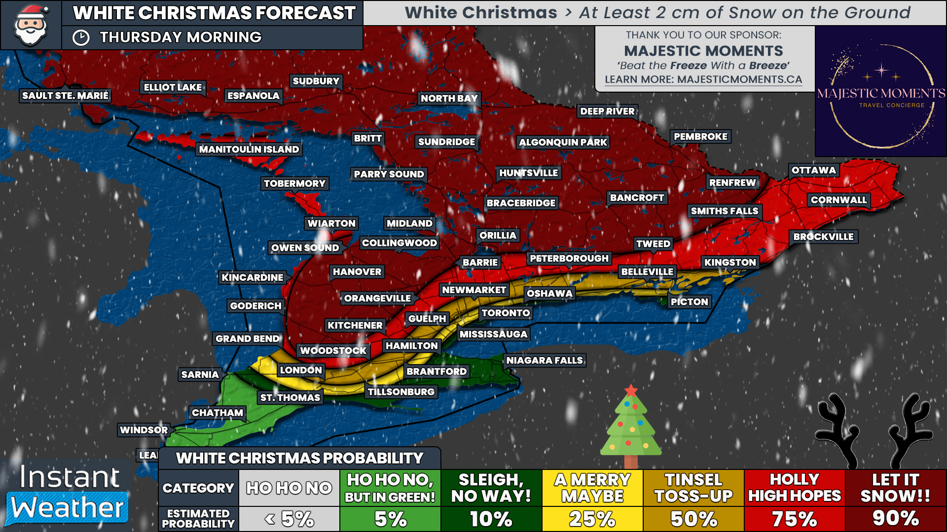
Putting all of this together, we have created our preliminary White Christmas forecast. This is not the final word and adjustments are possible as we get closer to Christmas morning. Several of the uncertainties mentioned above will resolve themselves over the next couple of days, giving us a clearer picture than the models can provide right now.
Our highest confidence area, where we can almost guarantee a White Christmas with a 90 percent chance, covers a wide swath of Central Ontario, including Muskoka, Bancroft and northern and western Simcoe County. These regions have a deep, well-established snowpack. East of Lake Huron, we also assign a 90 percent chance for Hanover and much of Huron and Perth Counties, where repeated lake effect snow has buried the landscape.
Outside of that core region, we currently have a 75 percent chance for much of Eastern Ontario, along with areas such as Peterborough, Barrie and Kitchener. Confidence is fairly strong here, thanks to the existing snow southeast of Georgian Bay and the expected system snowfall in Eastern Ontario on Tuesday.
That said, melting remains a concern for Barrie and Kitchener if temperatures rise a bit more than expected on Tuesday. For Eastern Ontario, confidence also depends on the system delivering as forecast, so we want to see that snow on the ground before bumping probabilities any higher.
Closer to Lake Ontario, the dream of a winter wonderland starts to fade. From Kingston through the north GTA corridor and extending into London, we currently place the odds at around 50 percent. Along the immediate Lake Ontario shoreline, including much of the GTA, things become even more questionable with only about a 25 percent chance of a White Christmas.
For those in the Niagara Region and Deep Southwestern Ontario, including Windsor, Chatham and Sarnia, it may take a true Christmas miracle. Unless a last-minute snowmaker slides through just before Christmas morning, it looks like the Grinch may win this one.
We will continue to monitor the forecast closely and provide updates as Christmas morning draws nearer. Keep checking back, because in the weather, especially at Christmas, surprises are always possible.


